Deck 19: Deserts and Winds
Full screen (f)
Question
Question
Question
Question
Question
Question
Question
Question
Question
Question
Question
Question
Question
Question
Question
Question
Question
Question
Question
Question
Question
Question
Question
Question
Question
Question
Question
Question
Question
Question
Question
Question
Question
Question
Question
Question
Question
Question
Question
Question
Question
Question
Question
Question
Question
Question
Question
Question
Question
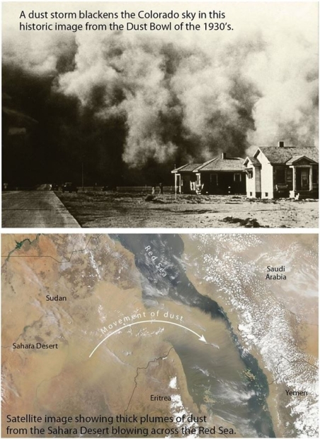
 What process is illustrated in this image?
A)Formation of a bajada
B)Rainshadow effect
C)Saltation
D)Migration of sand dunes
Question
Question
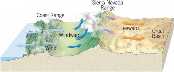 Why does the rainshadow desert form on the downwind side of the mountains?
A)The air mass has absorbed all the moisture on that side as it descended.
B)The mountains block wind from that region, making it hot.
C)The sediments on the downwind side are porous.
D)The moisture was precipitated from the air mass on the upwind side.
Question
Question
Question
Question
Question
Question
Question
Question
Question
Question
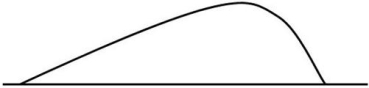 The figure above is a cross-section of a dune.Based on the shape of the dune, which way was the prevailing wind coming from?
A)Left
B)Right
C)Top
D)Bottom
Question
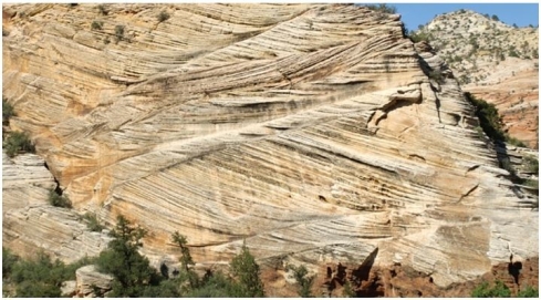 Which deposition of which desert landform would result in the angled layers visible in this image?
A)Inselberg
B)Desert pavement
C)Playa lake
D)Dune
Question
 What sedimentary structure is visible in this image?
A)Cross-bedding
B)Bedding
C)Deflation
D)Bajada
Question
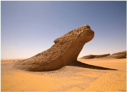
 What feature is visible in this image?
A)Blowout
B)Bajada
C)Desert pavement
D)Ventifact
Question
 Which part of the wind's sediment load is visible in this image?
A)Bed load
B)Saltated load
C)Dissolved load
D)Suspended load
Question
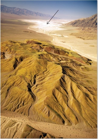 What desert feature is visible in this image, indicated by an arrow?
A)Playa lake
B)Desert varnish
C)Sand dunes
D)Inselberg
Question
 What feature is present in this image?
A)Blowout
B)Yardang
C)Desert pavement
D)Dune
Question
 How was this feature created?
A)Erosion via water
B)Scouring via ice
C)Deflation via wind
D)Deformation via stress
Question
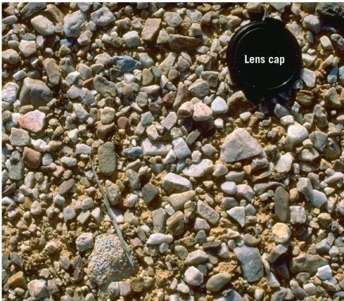 What desert feature is visible in this image?
A)Playa lake
B)Sand dune
C)Desert pavement
D)Yardang
Question
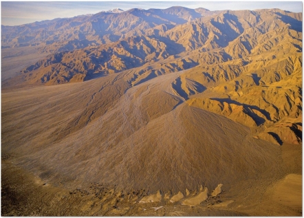 What desert landform is visible here?
A)Inselberg
B)Normal fault
C)Playa lake
D)Bajada
Question
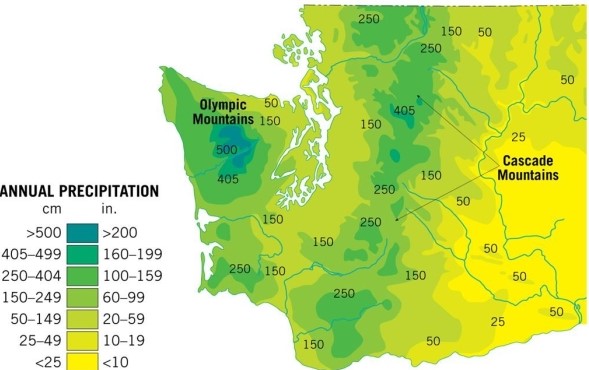 Based on the precipitation data available here, which region in Washington State would be the most likely location of a rainshadow desert?
A)West in the Olympic Mountains
B)Southeastern Washington
C)Central Washington in the Cascade Mountains
D)Southwestern Washington
Question
 What factor in this image would control the depth of this feature? (What might stop it from getting deeper?)
A)Presence of large boulders will stop the wind.
B)Sediment will be frozen in place.
C)Scouring will go down to bedrock and run out of sediment.
D)Presence of vegetation will hold sediment in place.

Unlock Deck
Sign up to unlock the cards in this deck!
Unlock Deck
Unlock Deck
1/72
Play
Full screen (f)
Deck 19: Deserts and Winds
1
Why doesn't interior drainage, such as the drainage that develops in deserts, flow out of the desert?
A)The water flows underground.
B)The water fills large lakes.
C)The water evaporates.
D)The water freezes.
A)The water flows underground.
B)The water fills large lakes.
C)The water evaporates.
D)The water freezes.
C
2
There are many names for ephemeral desert streams that remain empty for most of the year.Which of the following is not another name for an ephemeral desert stream?
A)Arroyo
B)Wadi
C)Playa
D)Wash
A)Arroyo
B)Wadi
C)Playa
D)Wash
C
3
Within water-deficient regions, two climatic types are recognized.What are they?
A)Subpolar high and subpolar low
B)Ephemeral and playa
C)Desert and steppe
D)Saltation and tropical
A)Subpolar high and subpolar low
B)Ephemeral and playa
C)Desert and steppe
D)Saltation and tropical
C
4
Traditionally, a region is defined as a desert if it receives less than ________ centimeters of rain per year.
A)10
B)25
C)15
D)2
A)10
B)25
C)15
D)2
Unlock Deck
Unlock for access to all 72 flashcards in this deck.
Unlock Deck
k this deck
5
Inselbergs are generally associated with a(n)________ stage desert landscape.
A)early
B)middle
C)late
A)early
B)middle
C)late
Unlock Deck
Unlock for access to all 72 flashcards in this deck.
Unlock Deck
k this deck
6
What percentage of Earth's land area is covered by dry regions such as deserts and steppes?
A)14 percent
B)30 percent
C)9 percent
D)50 percent
A)14 percent
B)30 percent
C)9 percent
D)50 percent
Unlock Deck
Unlock for access to all 72 flashcards in this deck.
Unlock Deck
k this deck
7
Which desert location in the United States consists of alternating mountain ranges and flat-bottomed valleys as a result of fault block mountains?
A)Rocky Mountains
B)Ohio River Valley
C)Marathon Uplift
D)Basin and Range Province
A)Rocky Mountains
B)Ohio River Valley
C)Marathon Uplift
D)Basin and Range Province
Unlock Deck
Unlock for access to all 72 flashcards in this deck.
Unlock Deck
k this deck
8
From a climatological perspective, a region is a desert if ________.
A)yearly precipitation exceeds evaporation
B)yearly precipitation is equal to evaporation
C)yearly precipitation is less than evaporation
A)yearly precipitation exceeds evaporation
B)yearly precipitation is equal to evaporation
C)yearly precipitation is less than evaporation
Unlock Deck
Unlock for access to all 72 flashcards in this deck.
Unlock Deck
k this deck
9
Which of the following desert landforms is carved from solid rock rather than consisting of accumulated sediments?
A)Playa
B)Inselberg
C)Alluvial fan
D)Bajada
A)Playa
B)Inselberg
C)Alluvial fan
D)Bajada
Unlock Deck
Unlock for access to all 72 flashcards in this deck.
Unlock Deck
k this deck
10
Most dry lands exist between ________ degrees latitude on either side of the equator.
A)50 and 60
B)35 and 40
C)20 and 30
D)0 and 10
A)50 and 60
B)35 and 40
C)20 and 30
D)0 and 10
Unlock Deck
Unlock for access to all 72 flashcards in this deck.
Unlock Deck
k this deck
11
In a desert environment, in which area would surface water infiltrate into the local groundwater system most effectively?
A)Playa lakes with thick mud bottoms
B)Streams flowing across an alluvial fan
C)Streams flowing across bare bedrock
D)Steep-walled mountain streams
A)Playa lakes with thick mud bottoms
B)Streams flowing across an alluvial fan
C)Streams flowing across bare bedrock
D)Steep-walled mountain streams
Unlock Deck
Unlock for access to all 72 flashcards in this deck.
Unlock Deck
k this deck
12
A true desert is defined by a lack of what substance?
A)Oxygen
B)Plant life
C)Rocks
D)Water
A)Oxygen
B)Plant life
C)Rocks
D)Water
Unlock Deck
Unlock for access to all 72 flashcards in this deck.
Unlock Deck
k this deck
13
Which of the following areas is known for its rainshadow deserts?
A)The Sahara in Africa
B)South America east of the Andes
C)Central Iran
D)Great Valley of Central California
A)The Sahara in Africa
B)South America east of the Andes
C)Central Iran
D)Great Valley of Central California
Unlock Deck
Unlock for access to all 72 flashcards in this deck.
Unlock Deck
k this deck
14
Which of the following statements about deserts is true?
A)Although rainfalls are infrequent, erosion and deposition related to water are important in deserts.
B)Deserts are located where there are ascending air masses and low atmospheric pressure.
C)Deserts are defined by their sand content.
D)Deserts are always located in hot, humid coastal areas.
A)Although rainfalls are infrequent, erosion and deposition related to water are important in deserts.
B)Deserts are located where there are ascending air masses and low atmospheric pressure.
C)Deserts are defined by their sand content.
D)Deserts are always located in hot, humid coastal areas.
Unlock Deck
Unlock for access to all 72 flashcards in this deck.
Unlock Deck
k this deck
15
How was the Salt Pan at Death Valley created? What is the name of such a desert feature?
A)Stream erosion; wadi
B)Precipitation; nullah
C)Evaporation; playa
D)Chemical reactions; ephemeral
A)Stream erosion; wadi
B)Precipitation; nullah
C)Evaporation; playa
D)Chemical reactions; ephemeral
Unlock Deck
Unlock for access to all 72 flashcards in this deck.
Unlock Deck
k this deck
16
Why do deserts lack thick deposits of soil?
A)Low temperatures and high soil moisture contents accelerate chemical weathering.
B)Warm temperatures and high soil moisture contents accelerate chemical weathering.
C)Warm temperatures and low soil moisture contents allow some mechanical weathering.
D)Temperature has no effect on rock weathering.
A)Low temperatures and high soil moisture contents accelerate chemical weathering.
B)Warm temperatures and high soil moisture contents accelerate chemical weathering.
C)Warm temperatures and low soil moisture contents allow some mechanical weathering.
D)Temperature has no effect on rock weathering.
Unlock Deck
Unlock for access to all 72 flashcards in this deck.
Unlock Deck
k this deck
17
________ weathering is most common in a desert environment.
A)Mechanical
B)Erosional
C)Chemical
D)Dissolution
A)Mechanical
B)Erosional
C)Chemical
D)Dissolution
Unlock Deck
Unlock for access to all 72 flashcards in this deck.
Unlock Deck
k this deck
18
________ refers to the bouncing motion sands will display when transported by moving water or wind.
A)Yardang
B)Saltation
C)Deflation
D)Slithering
A)Yardang
B)Saltation
C)Deflation
D)Slithering
Unlock Deck
Unlock for access to all 72 flashcards in this deck.
Unlock Deck
k this deck
19
What is the definition of an ephemeral stream?
A)A distributary channel on a stream delta
B)A stream that meanders back and forth across a valley
C)A stream that has interweaving channels and is choked with sediment
D)An intermittent stream that only has water after specific episodes of rain
A)A distributary channel on a stream delta
B)A stream that meanders back and forth across a valley
C)A stream that has interweaving channels and is choked with sediment
D)An intermittent stream that only has water after specific episodes of rain
Unlock Deck
Unlock for access to all 72 flashcards in this deck.
Unlock Deck
k this deck
20
Which of the following can contain large quantities of evaporite minerals such as borate and halite?
A)Playa
B)Inselberg
C)Alluvial fan
D)Bajada
A)Playa
B)Inselberg
C)Alluvial fan
D)Bajada
Unlock Deck
Unlock for access to all 72 flashcards in this deck.
Unlock Deck
k this deck
21
What is a yardang?
A)A wind-sculpted landform oriented parallel to the prevailing wind, often narrow at the base
B)A small rock polished and pitted on the exposed surface
C)A shallow depression created by deflation
D)A pit worn into a rock by circular currents of flowing water
A)A wind-sculpted landform oriented parallel to the prevailing wind, often narrow at the base
B)A small rock polished and pitted on the exposed surface
C)A shallow depression created by deflation
D)A pit worn into a rock by circular currents of flowing water
Unlock Deck
Unlock for access to all 72 flashcards in this deck.
Unlock Deck
k this deck
22
The world's driest desert is the Atacama Desert in South America.
Unlock Deck
Unlock for access to all 72 flashcards in this deck.
Unlock Deck
k this deck
23
A(n)________ is a smooth, polished rock that has been abraded by the wind.
A)blowout
B)bajada
C)inselberg
D)ventifact
A)blowout
B)bajada
C)inselberg
D)ventifact
Unlock Deck
Unlock for access to all 72 flashcards in this deck.
Unlock Deck
k this deck
24
A true desert is defined by how hot it is.
Unlock Deck
Unlock for access to all 72 flashcards in this deck.
Unlock Deck
k this deck
25
The world's largest arid desert is the Sahara.
Unlock Deck
Unlock for access to all 72 flashcards in this deck.
Unlock Deck
k this deck
26
The ________ was a period of drought in the 1930s in the United States that resulted in significant dust storms blowing fine sediment for hundreds of miles.
A)Dust Bowl
B)driftless area
C)rainshadow
D)basin and range
A)Dust Bowl
B)driftless area
C)rainshadow
D)basin and range
Unlock Deck
Unlock for access to all 72 flashcards in this deck.
Unlock Deck
k this deck
27
Middle-latitude deserts and steppes are more numerous and extensive in the Northern Hemisphere than in the Southern Hemisphere.
Unlock Deck
Unlock for access to all 72 flashcards in this deck.
Unlock Deck
k this deck
28
There is no one maximum depth for desert blowouts.They vary in depth depending on conditions present at the location.What controls the depth of all blowouts?
A)Force of the moving wind
B)Velocity of water eddy
C)Elevation of water table
D)Amount of water available for dissolution of underlying materials
A)Force of the moving wind
B)Velocity of water eddy
C)Elevation of water table
D)Amount of water available for dissolution of underlying materials
Unlock Deck
Unlock for access to all 72 flashcards in this deck.
Unlock Deck
k this deck
29
Which set of characteristics would best fit a geologically recent fault block mountain uplift?
A)Large, broad bajadas with many inselbergs
B)Small playas and large alluvial fans
C)Flat upland surface, steep slopes, and small alluvial fans
D)Extensive playas ringed by large sand dunes
A)Large, broad bajadas with many inselbergs
B)Small playas and large alluvial fans
C)Flat upland surface, steep slopes, and small alluvial fans
D)Extensive playas ringed by large sand dunes
Unlock Deck
Unlock for access to all 72 flashcards in this deck.
Unlock Deck
k this deck
30
What process creates desert blowouts?
A)Moving water
B)Evaporation
C)Herd animals pawing at the ground
D)Deflation by wind
A)Moving water
B)Evaporation
C)Herd animals pawing at the ground
D)Deflation by wind
Unlock Deck
Unlock for access to all 72 flashcards in this deck.
Unlock Deck
k this deck
31
Which size(s)of sediment commonly make up most of wind's suspended load?
A)Sand
B)Clay
C)Silt
D)Gravel
A)Sand
B)Clay
C)Silt
D)Gravel
Unlock Deck
Unlock for access to all 72 flashcards in this deck.
Unlock Deck
k this deck
32
________ are mounds and ridges of sand that are deposited by the wind.
A)Ventifacts
B)Desert pavements
C)Blowouts
D)Dunes
A)Ventifacts
B)Desert pavements
C)Blowouts
D)Dunes
Unlock Deck
Unlock for access to all 72 flashcards in this deck.
Unlock Deck
k this deck
33
Which one of the following statements about landforms is correct?
A)Alluvial fans typically rim desert valleys.
B)Playas form on high cuestas in arid areas.
C)Inselbergs are composed of coarse sands and gravels.
D)Inselbergs are found in low, circular depressions.
A)Alluvial fans typically rim desert valleys.
B)Playas form on high cuestas in arid areas.
C)Inselbergs are composed of coarse sands and gravels.
D)Inselbergs are found in low, circular depressions.
Unlock Deck
Unlock for access to all 72 flashcards in this deck.
Unlock Deck
k this deck
34
What are the two primary sources for loess?
A)Lakes and streams
B)Deserts and glacial deposits
C)Atmosphere and volcanoes
D)Shallow seas and lakes
A)Lakes and streams
B)Deserts and glacial deposits
C)Atmosphere and volcanoes
D)Shallow seas and lakes
Unlock Deck
Unlock for access to all 72 flashcards in this deck.
Unlock Deck
k this deck
35
Deposits of silt carried by blowing winds are referred to as ________.
A)deflation deposits
B)loess
C)eolian sands
D)alluvium
A)deflation deposits
B)loess
C)eolian sands
D)alluvium
Unlock Deck
Unlock for access to all 72 flashcards in this deck.
Unlock Deck
k this deck
36
Which mechanical weathering process will be most common in an arid environment?
A)Salt wedging
B)Abrasion
C)Root wedging
D)Exfoliation
A)Salt wedging
B)Abrasion
C)Root wedging
D)Exfoliation
Unlock Deck
Unlock for access to all 72 flashcards in this deck.
Unlock Deck
k this deck
37
Salt wedging is a weathering process that is more common in humid areas than arid.
Unlock Deck
Unlock for access to all 72 flashcards in this deck.
Unlock Deck
k this deck
38
Why is it so difficult for wind to pick up clay-sized particles?
A)They are too large for the wind to carry.
B)The wind has a near-zero velocity closest to the surface and can't pick them up.
C)The clay particles are often buried under larger sediments.
D)There is too much clay to carry.
A)They are too large for the wind to carry.
B)The wind has a near-zero velocity closest to the surface and can't pick them up.
C)The clay particles are often buried under larger sediments.
D)There is too much clay to carry.
Unlock Deck
Unlock for access to all 72 flashcards in this deck.
Unlock Deck
k this deck
39
Streams in arid areas generally lack an extensive network of tributaries because they tend to be ephemeral.
Unlock Deck
Unlock for access to all 72 flashcards in this deck.
Unlock Deck
k this deck
40
The central United States is covered with extensive deposits of loess.Where did this loess come from?
A)Alluvium deposited during major floods
B)Rock flour from the braid plains of Pleistocene glacial streams and rivers
C)Decomposing sandstone from the St.Peter Sandstone
D)Weathering and erosion of western mountains
A)Alluvium deposited during major floods
B)Rock flour from the braid plains of Pleistocene glacial streams and rivers
C)Decomposing sandstone from the St.Peter Sandstone
D)Weathering and erosion of western mountains
Unlock Deck
Unlock for access to all 72 flashcards in this deck.
Unlock Deck
k this deck
41
Wind in arid regions produces more erosional landforms than depositional landforms.
Unlock Deck
Unlock for access to all 72 flashcards in this deck.
Unlock Deck
k this deck
42
What role (if any)will our changing climate play in future desertification?
Unlock Deck
Unlock for access to all 72 flashcards in this deck.
Unlock Deck
k this deck
43
Compare and contrast major floods in a humid environment (i.e., along the Mississippi River)against those in a desert environment.
Unlock Deck
Unlock for access to all 72 flashcards in this deck.
Unlock Deck
k this deck
44
The Basin and Range Province of the American southwest is known for containing regions that display each stand of landscape evolution in an arid climate.
Unlock Deck
Unlock for access to all 72 flashcards in this deck.
Unlock Deck
k this deck
45
Compare and contrast sediment transportation by wind and by water.
Unlock Deck
Unlock for access to all 72 flashcards in this deck.
Unlock Deck
k this deck
46
Wind is the most powerful agent of erosion in a desert.
Unlock Deck
Unlock for access to all 72 flashcards in this deck.
Unlock Deck
k this deck
47
Sandstorms should be more accurately referred to as siltstorms because most sediment carried by wind for long distances is actually silt-sized.
Unlock Deck
Unlock for access to all 72 flashcards in this deck.
Unlock Deck
k this deck
48
Explain how circulation patterns in the atmosphere generate the bands of low-latitude deserts around the equator.
Unlock Deck
Unlock for access to all 72 flashcards in this deck.
Unlock Deck
k this deck
49
What process is illustrated in this image?A)Formation of a bajada
B)Rainshadow effect
C)Saltation
D)Migration of sand dunes
Unlock Deck
Unlock for access to all 72 flashcards in this deck.
Unlock Deck
k this deck
50
Streams in arid regions are generally small and die out before reaching the sea.Explain two ways that streams lose water in this environment and why this loss occurs.
Unlock Deck
Unlock for access to all 72 flashcards in this deck.
Unlock Deck
k this deck
51
Why does the rainshadow desert form on the downwind side of the mountains?A)The air mass has absorbed all the moisture on that side as it descended.
B)The mountains block wind from that region, making it hot.
C)The sediments on the downwind side are porous.
D)The moisture was precipitated from the air mass on the upwind side.
Unlock Deck
Unlock for access to all 72 flashcards in this deck.
Unlock Deck
k this deck
52
What are the three stages of desert landscape evolution? Provide examples of landforms for each.
Unlock Deck
Unlock for access to all 72 flashcards in this deck.
Unlock Deck
k this deck
53
Rates of physical weathering in deserts are high, even though there isn't a great deal of precipitation, because it is usually heavy when rain does fall.
Unlock Deck
Unlock for access to all 72 flashcards in this deck.
Unlock Deck
k this deck
54
How can cold coastal currents along the west coasts of continents generate subtropical deserts?
Unlock Deck
Unlock for access to all 72 flashcards in this deck.
Unlock Deck
k this deck
55
Moving wind that is free of sediment is enough to create a ventifact.
Unlock Deck
Unlock for access to all 72 flashcards in this deck.
Unlock Deck
k this deck
56
Due to the lack of chemical weathering, there is a great deal of clay-sized sediment in desert areas.
Unlock Deck
Unlock for access to all 72 flashcards in this deck.
Unlock Deck
k this deck
57
Fine particles such as clays and silts are often flat and platy in shape.Evaluate their ability to be transported by wind based on this shape.
Unlock Deck
Unlock for access to all 72 flashcards in this deck.
Unlock Deck
k this deck
58
Explain how the environmental conditions in the headwaters of the Colorado River affect the longevity of the river as it moves through the desert.
Unlock Deck
Unlock for access to all 72 flashcards in this deck.
Unlock Deck
k this deck
59
Why is erosion by wind more effective in an arid region than in a humid region?
Unlock Deck
Unlock for access to all 72 flashcards in this deck.
Unlock Deck
k this deck
60
Saltating sand grains in a desert are carried by the wind and rarely more than 1 meter above the surface in normal circumstances.
Unlock Deck
Unlock for access to all 72 flashcards in this deck.
Unlock Deck
k this deck
61
The figure above is a cross-section of a dune.Based on the shape of the dune, which way was the prevailing wind coming from?A)Left
B)Right
C)Top
D)Bottom
Unlock Deck
Unlock for access to all 72 flashcards in this deck.
Unlock Deck
k this deck
62
Which deposition of which desert landform would result in the angled layers visible in this image?A)Inselberg
B)Desert pavement
C)Playa lake
D)Dune
Unlock Deck
Unlock for access to all 72 flashcards in this deck.
Unlock Deck
k this deck
63
What sedimentary structure is visible in this image?A)Cross-bedding
B)Bedding
C)Deflation
D)Bajada
Unlock Deck
Unlock for access to all 72 flashcards in this deck.
Unlock Deck
k this deck
64
What feature is visible in this image?A)Blowout
B)Bajada
C)Desert pavement
D)Ventifact
Unlock Deck
Unlock for access to all 72 flashcards in this deck.
Unlock Deck
k this deck
65
Which part of the wind's sediment load is visible in this image?A)Bed load
B)Saltated load
C)Dissolved load
D)Suspended load
Unlock Deck
Unlock for access to all 72 flashcards in this deck.
Unlock Deck
k this deck
66
What desert feature is visible in this image, indicated by an arrow?A)Playa lake
B)Desert varnish
C)Sand dunes
D)Inselberg
Unlock Deck
Unlock for access to all 72 flashcards in this deck.
Unlock Deck
k this deck
67
What feature is present in this image?A)Blowout
B)Yardang
C)Desert pavement
D)Dune
Unlock Deck
Unlock for access to all 72 flashcards in this deck.
Unlock Deck
k this deck
68
How was this feature created?A)Erosion via water
B)Scouring via ice
C)Deflation via wind
D)Deformation via stress
Unlock Deck
Unlock for access to all 72 flashcards in this deck.
Unlock Deck
k this deck
69
What desert feature is visible in this image?A)Playa lake
B)Sand dune
C)Desert pavement
D)Yardang
Unlock Deck
Unlock for access to all 72 flashcards in this deck.
Unlock Deck
k this deck
70
What desert landform is visible here?A)Inselberg
B)Normal fault
C)Playa lake
D)Bajada
Unlock Deck
Unlock for access to all 72 flashcards in this deck.
Unlock Deck
k this deck
71
Based on the precipitation data available here, which region in Washington State would be the most likely location of a rainshadow desert?A)West in the Olympic Mountains
B)Southeastern Washington
C)Central Washington in the Cascade Mountains
D)Southwestern Washington
Unlock Deck
Unlock for access to all 72 flashcards in this deck.
Unlock Deck
k this deck
72
What factor in this image would control the depth of this feature? (What might stop it from getting deeper?)A)Presence of large boulders will stop the wind.
B)Sediment will be frozen in place.
C)Scouring will go down to bedrock and run out of sediment.
D)Presence of vegetation will hold sediment in place.
Unlock Deck
Unlock for access to all 72 flashcards in this deck.
Unlock Deck
k this deck
Unlock Deck
Unlock for access to all 72 flashcards in this deck.


