Deck 12: Earthquakes and Earths Interior
Full screen (f)
Question
Question
Question
Question
Question
In what order will the seismic stations #1 and #2) detect seismic waves generated by the earthquake shown in the image? 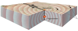
A) Station 1 will detect them first, followed by Station 2.
B) Station 2 will detect them first, followed by Station 1.
C) Stations 1 and 2 will detect the waves at the same time.
D) Only station 2 will detect waves because Station 1 is too close to the hypocenter.
A) Station 1 will detect them first, followed by Station 2.
B) Station 2 will detect them first, followed by Station 1.
C) Stations 1 and 2 will detect the waves at the same time.
D) Only station 2 will detect waves because Station 1 is too close to the hypocenter.
Question
The earthquake location shown as the red dot is generated on what type of fault? 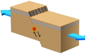
A) reverse fault
B) normal fault
C) thrust fault
D) strike-slip fault
A) reverse fault
B) normal fault
C) thrust fault
D) strike-slip fault
Question
What do the two stars near the center of this block represent? 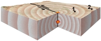
A) the location of the earthquake
B) the star at depth is the place where the earthquake is generated
C) the star at depth is the hypocenter
D) the star on the surface is the epicenter
E) all of these
A) the location of the earthquake
B) the star at depth is the place where the earthquake is generated
C) the star at depth is the hypocenter
D) the star on the surface is the epicenter
E) all of these
Question
Question
An earthquake generated on this type of fault would most likely be associated with a: 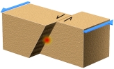
A) subduction zone
B) divergent plate boundary
C) rift
D) caldera
E) transform boundary
A) subduction zone
B) divergent plate boundary
C) rift
D) caldera
E) transform boundary
Question
Question
On this map of southeastern Asia and adjacent areas, which site would have earthquakes along a mid-ocean ridge? 
A) 1, in the Indian Ocean
B) 2, in Tibet
C) 3, near Japan
D) 4, near the Tonga island arc
A) 1, in the Indian Ocean
B) 2, in Tibet
C) 3, near Japan
D) 4, near the Tonga island arc
Question
What is illustrated by this figure? 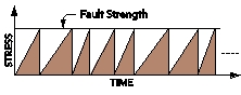
A) stress consistently increases through time
B) stress consistently decreases through time
C) as stress increases, the fault strength increases
D) stress increases until it matches the strength of the fault, and then stress decreases
A) stress consistently increases through time
B) stress consistently decreases through time
C) as stress increases, the fault strength increases
D) stress increases until it matches the strength of the fault, and then stress decreases
Question
What is true about the earthquakes on this figure at points A and B)? 
A) for each earthquake, the epicenter and hypocenter are located close together
B) neither earthquake is related to the volcano
C) an eruption makes loud noises but not seismic waves
D) landslides cause death but not seismic waves
A) for each earthquake, the epicenter and hypocenter are located close together
B) neither earthquake is related to the volcano
C) an eruption makes loud noises but not seismic waves
D) landslides cause death but not seismic waves
Question
The image shows a surface expression of slip along a normal fault caused by an earthquake. What is the indicated feature? 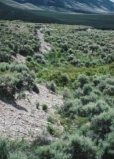
A) fault scarp
B) hanging wall
C) graben
D) hypocenter
A) fault scarp
B) hanging wall
C) graben
D) hypocenter
Question
Question
Question
The fault scarp in this photograph apparently formed: 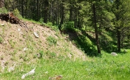
A) when an earthquake rupture offset the surface
B) when the area beneath the car was dropped down relative to the area to the left
C) more than 50 million years ago
D) when material on the left was compacted
E) all of these
A) when an earthquake rupture offset the surface
B) when the area beneath the car was dropped down relative to the area to the left
C) more than 50 million years ago
D) when material on the left was compacted
E) all of these
Question
Question
Question
Question
Question
On this map of southeastern Asia and adjacent areas, which site would have earthquakes along a continental collision? 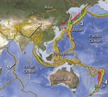
A) 1, in the Indian Ocean
B) 2, in Tibet
C) 3, near Japan
D) 4, near the Tonga island arc
A) 1, in the Indian Ocean
B) 2, in Tibet
C) 3, near Japan
D) 4, near the Tonga island arc
Question
Question
The continental block shown in this figure has a transform boundary, a reverse fault, and a continental rift. What type of activity could cause an earthquake here? 
A) strike-slip faulting
B) normal faulting
C) reverse faulting
D) movement of magma near the rift
E) all of these
A) strike-slip faulting
B) normal faulting
C) reverse faulting
D) movement of magma near the rift
E) all of these
Question
How would this diagram change if the seismic station was farther from the earthquake? 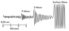
A) the P-waves would arrive later
B) the S-waves would arrive later
C) there would be a larger gap between the arrives of the P- and S-waves
D) all of these
A) the P-waves would arrive later
B) the S-waves would arrive later
C) there would be a larger gap between the arrives of the P- and S-waves
D) all of these
Question
On this map of South America and adjacent areas, which site would have the deepest earthquakes? 
A) 1, the oceanic trench
B) 2, below the magmatic belt
C) 3, along a passive margin
D) 4, in the middle of the Atlantic Ocean
E) both 1 and 2
A) 1, the oceanic trench
B) 2, below the magmatic belt
C) 3, along a passive margin
D) 4, in the middle of the Atlantic Ocean
E) both 1 and 2
Question
On this map of South America and adjacent areas, which site would have earthquakes along a subduction zone? 
A) 1, the oceanic trench
B) 2, below the magmatic belt
C) 3, along a passive margin
D) 4, in the middle of the Atlantic Ocean
E) both 1 and 2
A) 1, the oceanic trench
B) 2, below the magmatic belt
C) 3, along a passive margin
D) 4, in the middle of the Atlantic Ocean
E) both 1 and 2
Question
Most large earthquakes on subduction zones occur because of: 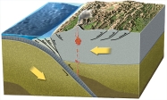
A) warming of cold oceanic crust
B) melting of cold oceanic crust
C) melting of the mantle
D) energy released in erupting volcanoes
E) faulting along the plate boundary
A) warming of cold oceanic crust
B) melting of cold oceanic crust
C) melting of the mantle
D) energy released in erupting volcanoes
E) faulting along the plate boundary
Question
On this map of southeastern Asia and adjacent areas, which site would have earthquakes along a subduction zone? 
A) 1, in the Indian Ocean
B) 2, in Tibet
C) 3, near Japan
D) 4, near the Tonga island arc
E) 3 and 4
A) 1, in the Indian Ocean
B) 2, in Tibet
C) 3, near Japan
D) 4, near the Tonga island arc
E) 3 and 4
Question
This diagram indicates that: 
A) S-waves are the first wave to arrive at station and then die out into P-waves
B) S-waves are the last wave to arrive at the station
C) P-waves arrive first, followed by S-waves
D) surface waves arrive first, followed by S-waves and then P-waves
E) surface waves cause the smallest vibrations
A) S-waves are the first wave to arrive at station and then die out into P-waves
B) S-waves are the last wave to arrive at the station
C) P-waves arrive first, followed by S-waves
D) surface waves arrive first, followed by S-waves and then P-waves
E) surface waves cause the smallest vibrations
Question
On this map of earthquakes near Japan, why do shallow earthquakes occur to the east and deeper earthquakes occur to the west? 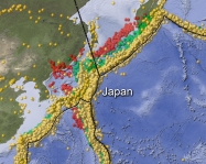
A) the continental crust is thicker to the east
B) the crust is hotter near Japan, closer to the volcanoes
C) there is a continental collision to the east
D) the subduction zone dips to the west
A) the continental crust is thicker to the east
B) the crust is hotter near Japan, closer to the volcanoes
C) there is a continental collision to the east
D) the subduction zone dips to the west
Question
Question
Question
Question
Question
Question
On this map of South America and adjacent areas, which site would have earthquakes related to plate divergence? 
A) 1, the oceanic trench
B) 2, below the magmatic belt
C) 3, along a passive margin
D) 4, in the middle of the Atlantic Ocean
E) both 1 and 2
A) 1, the oceanic trench
B) 2, below the magmatic belt
C) 3, along a passive margin
D) 4, in the middle of the Atlantic Ocean
E) both 1 and 2
Question
Question
Question
Where do most earthquakes occur near mid-ocean ridges? 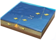
A) at great depths more than 100 km)
B) along the axis of the ridge and on transform faults that connect ridge segments
C) in the asthenosphere where mantle undergoes decompression melting
D) on the boundary between the mantle and the oceanic crust
E) all of these
A) at great depths more than 100 km)
B) along the axis of the ridge and on transform faults that connect ridge segments
C) in the asthenosphere where mantle undergoes decompression melting
D) on the boundary between the mantle and the oceanic crust
E) all of these
Question
Question
Question
Question
Question
Question
Question
Question
The shaded areas on this map have significant earthquake risks because: 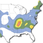
A) the area is near an active plate boundary
B) the area is over a subduction zone
C) there are many active strike-slip faults
D) stress generated on far-off plate boundaries can reactivate ancient faults
A) the area is near an active plate boundary
B) the area is over a subduction zone
C) there are many active strike-slip faults
D) stress generated on far-off plate boundaries can reactivate ancient faults
Question
The image indicates that: 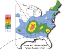
A) two major zones exist for earthquake risk in the eastern United States
B) the risk for earthquakes in extreme southeast Missouri is very low
C) the eastern United States is under no risk for earthquakes
D) Florida has the highest risk for earthquakes along the east coast
A) two major zones exist for earthquake risk in the eastern United States
B) the risk for earthquakes in extreme southeast Missouri is very low
C) the eastern United States is under no risk for earthquakes
D) Florida has the highest risk for earthquakes along the east coast
Question
The Modified Mercalli Intensity rating map on the right shows intensity values that range from more than X to less than III. What does this map show? 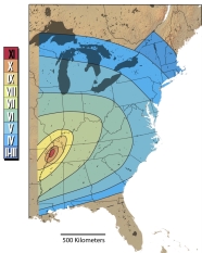
A) this earthquake had a Richter magnitude of 10 or 11 near the source
B) this earthquake had a Richter magnitude of 3 or 6 along the East Coast
C) the earthquake was not felt in southern Florida
D) shaking was felt only very near to the earthquake
E) building damage occurred in all of the zones that are shaded on this map
Question
On this time-travel curve, if a large earthquake is 400 km away from the station, what can you say about the arrivals of the P- and S-waves? 
A) the P-waves will arrive 40 seconds before the S-waves
B) the P-waves will arrive 400 seconds before the S-waves
C) no S-waves will arrive at this distance from the earthquake
D) none of these
A) the P-waves will arrive 40 seconds before the S-waves
B) the P-waves will arrive 400 seconds before the S-waves
C) no S-waves will arrive at this distance from the earthquake
D) none of these
Question
What likely caused much of the damage shown in this photograph in the 1906 San Francisco earthquake? 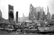
A) a breakdown in the computerized warning system
B) a tsunami
C) fires that broke out after the earthquake
D) ground ruptures, cracks, and fissures
A) a breakdown in the computerized warning system
B) a tsunami
C) fires that broke out after the earthquake
D) ground ruptures, cracks, and fissures
Question
Based on the three seismograms, which seismic station was closest to the epicenter of the earthquake? 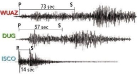
A) ISCO
B) DUG
C) WUAZ
D) All stations were the same distance from the earthquake
A) ISCO
B) DUG
C) WUAZ
D) All stations were the same distance from the earthquake
Question
The diagram on the right shows the record of one earthquake on seismograms at three different stations in a seismic network. These three seismograms show: 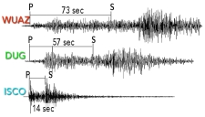
A) ISCO station is closest to the earthquake
B) WUAZ station was right at the earthquake
C) DUG station is farthest from the earthquake
D) WUAZ is the closest station, followed by DUG, and then ISCO
E) none of these
A) ISCO station is closest to the earthquake
B) WUAZ station was right at the earthquake
C) DUG station is farthest from the earthquake
D) WUAZ is the closest station, followed by DUG, and then ISCO
E) none of these
Question
Using this nomogram, what is the magnitude of an earthquake that is 500 km from a seismic station and has an amplitude of 0.2 mm? 
A) 2.0
B) 4.0
C) 6.0
D) 7.0
E) 10.2
A) 2.0
B) 4.0
C) 6.0
D) 7.0
E) 10.2
Question
Question
Question
Question
Question
The diagram on the right shows data from a single earthquake plotted on a diagram that shows the mathematical relationship between distance, magnitude, and S-wave amplitude. What do these data show? 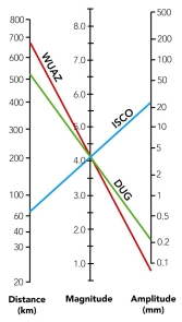
A) the distance between stations WUAZ and DUG is 680 km
B) station ISCO is 22 km from the earthquake epicenter
C) the local magnitude of the earthquake recorded by these three stations is 4.1 MI
D) station DUG was closest to the earthquake
A) the distance between stations WUAZ and DUG is 680 km
B) station ISCO is 22 km from the earthquake epicenter
C) the local magnitude of the earthquake recorded by these three stations is 4.1 MI
D) station DUG was closest to the earthquake
Question
Question
Question
Question
What feature suggests that this is a strike-slip fault rather than some other kind of fault? 
A) the presence of a fault scarp
B) the soft appearance of the landscape
C) the horizontal offset of the drainage channel
D) differences in vegetation across the fault
E) the lack of human development
A) the presence of a fault scarp
B) the soft appearance of the landscape
C) the horizontal offset of the drainage channel
D) differences in vegetation across the fault
E) the lack of human development
Question
Question
Question
Question
Question
Question
On this map of South America and adjacent areas, which site would most likely generate a tsunami? 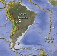
A) 1, the oceanic trench
B) 2, below the magmatic belt
C) 3, along a passive margin
D) 4, in the middle of the Atlantic Ocean
A) 1, the oceanic trench
B) 2, below the magmatic belt
C) 3, along a passive margin
D) 4, in the middle of the Atlantic Ocean
Question
Question
Question
Question
Question
Question
Question
Question
Question
In the trench pictured to the right, the information most important to a geologist studying a prehistoric earthquake is: 
A) there are layers of sediment and soil
B) the sediment is light colored
C) there is a vertical crack in the trench wall
D) the layers have been offset a measurable distance across a crack
A) there are layers of sediment and soil
B) the sediment is light colored
C) there is a vertical crack in the trench wall
D) the layers have been offset a measurable distance across a crack
Question
Which feature might indicate that this area has relatively recent earthquakes? 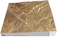
A) a change in topography across the structure
B) the presence of a fault scarp
C) the bends in streams
D) the steam channels on the right side that no longer continue onto the left side
E) all of these
A) a change in topography across the structure
B) the presence of a fault scarp
C) the bends in streams
D) the steam channels on the right side that no longer continue onto the left side
E) all of these

Unlock Deck
Sign up to unlock the cards in this deck!
Unlock Deck
Unlock Deck
1/119
Play
Full screen (f)
Deck 12: Earthquakes and Earths Interior
1
What was the main cause of death associated with the 2004 Indonesian earthquake?
A) poor construction of buildings
B) ground shaking that caused the soil to turn to a liquid
C) a large ocean wave or tsunami
D) massive fires along the coast
A) poor construction of buildings
B) ground shaking that caused the soil to turn to a liquid
C) a large ocean wave or tsunami
D) massive fires along the coast
C
2
Most earthquakes occur at depths of:
A) less than 100 km
B) greater than 100 km
C) 100-700 km
A) less than 100 km
B) greater than 100 km
C) 100-700 km
A
3
Which of the following types of faults does NOT generate earthquakes?
A) normal fault
B) reverse fault
C) thrust fault
D) strike-slip fault
E) all types of faults can generate earthquakes
A) normal fault
B) reverse fault
C) thrust fault
D) strike-slip fault
E) all types of faults can generate earthquakes
E
4
Earthquakes in subduction zones generally only occur at depths of:
A) up to 700 km
B) greater than 700 km
C) 700-1000 km
A) up to 700 km
B) greater than 700 km
C) 700-1000 km
Unlock Deck
Unlock for access to all 119 flashcards in this deck.
Unlock Deck
k this deck
5
In what order will the seismic stations #1 and #2) detect seismic waves generated by the earthquake shown in the image?
A) Station 1 will detect them first, followed by Station 2.
B) Station 2 will detect them first, followed by Station 1.
C) Stations 1 and 2 will detect the waves at the same time.
D) Only station 2 will detect waves because Station 1 is too close to the hypocenter.
A) Station 1 will detect them first, followed by Station 2.
B) Station 2 will detect them first, followed by Station 1.
C) Stations 1 and 2 will detect the waves at the same time.
D) Only station 2 will detect waves because Station 1 is too close to the hypocenter.
Unlock Deck
Unlock for access to all 119 flashcards in this deck.
Unlock Deck
k this deck
6
The earthquake location shown as the red dot is generated on what type of fault?
A) reverse fault
B) normal fault
C) thrust fault
D) strike-slip fault
A) reverse fault
B) normal fault
C) thrust fault
D) strike-slip fault
Unlock Deck
Unlock for access to all 119 flashcards in this deck.
Unlock Deck
k this deck
7
What do the two stars near the center of this block represent?
A) the location of the earthquake
B) the star at depth is the place where the earthquake is generated
C) the star at depth is the hypocenter
D) the star on the surface is the epicenter
E) all of these
A) the location of the earthquake
B) the star at depth is the place where the earthquake is generated
C) the star at depth is the hypocenter
D) the star on the surface is the epicenter
E) all of these
Unlock Deck
Unlock for access to all 119 flashcards in this deck.
Unlock Deck
k this deck
8
When do rocks along a fault have the highest amount of stress and stored elastic strain?
A) right before an earthquake
B) right after an earthquake
C) several weeks or months after an earthquake
D) none of these because rocks cannot behave in an elastic manner
A) right before an earthquake
B) right after an earthquake
C) several weeks or months after an earthquake
D) none of these because rocks cannot behave in an elastic manner
Unlock Deck
Unlock for access to all 119 flashcards in this deck.
Unlock Deck
k this deck
9
An earthquake generated on this type of fault would most likely be associated with a:
A) subduction zone
B) divergent plate boundary
C) rift
D) caldera
E) transform boundary
A) subduction zone
B) divergent plate boundary
C) rift
D) caldera
E) transform boundary
Unlock Deck
Unlock for access to all 119 flashcards in this deck.
Unlock Deck
k this deck
10
Earthquakes may be caused by:
A) movement along faults
B) volcanic eruptions and magma movement
C) landslides
D) explosions and human activity
E) all of these may be caused by earthquakes
A) movement along faults
B) volcanic eruptions and magma movement
C) landslides
D) explosions and human activity
E) all of these may be caused by earthquakes
Unlock Deck
Unlock for access to all 119 flashcards in this deck.
Unlock Deck
k this deck
11
On this map of southeastern Asia and adjacent areas, which site would have earthquakes along a mid-ocean ridge?
A) 1, in the Indian Ocean
B) 2, in Tibet
C) 3, near Japan
D) 4, near the Tonga island arc
A) 1, in the Indian Ocean
B) 2, in Tibet
C) 3, near Japan
D) 4, near the Tonga island arc
Unlock Deck
Unlock for access to all 119 flashcards in this deck.
Unlock Deck
k this deck
12
What is illustrated by this figure?
A) stress consistently increases through time
B) stress consistently decreases through time
C) as stress increases, the fault strength increases
D) stress increases until it matches the strength of the fault, and then stress decreases
A) stress consistently increases through time
B) stress consistently decreases through time
C) as stress increases, the fault strength increases
D) stress increases until it matches the strength of the fault, and then stress decreases
Unlock Deck
Unlock for access to all 119 flashcards in this deck.
Unlock Deck
k this deck
13
What is true about the earthquakes on this figure at points A and B)?
A) for each earthquake, the epicenter and hypocenter are located close together
B) neither earthquake is related to the volcano
C) an eruption makes loud noises but not seismic waves
D) landslides cause death but not seismic waves
A) for each earthquake, the epicenter and hypocenter are located close together
B) neither earthquake is related to the volcano
C) an eruption makes loud noises but not seismic waves
D) landslides cause death but not seismic waves
Unlock Deck
Unlock for access to all 119 flashcards in this deck.
Unlock Deck
k this deck
14
The image shows a surface expression of slip along a normal fault caused by an earthquake. What is the indicated feature?
A) fault scarp
B) hanging wall
C) graben
D) hypocenter
A) fault scarp
B) hanging wall
C) graben
D) hypocenter
Unlock Deck
Unlock for access to all 119 flashcards in this deck.
Unlock Deck
k this deck
15
Which of the following is NOT a way that volcanoes and magma can cause earthquakes?
A) Volcanic explosions cause seismic waves.
B) Volcanoes can load the crust, causing faulting and earthquakes.
C) Many volcanoes have steep, unstable slopes that can cause landslides that shake the ground.
D) Moving magma within or below the volcano can cause earthquakes.
E) All of these are ways that volcanoes can cause earthquakes.
Unlock Deck
Unlock for access to all 119 flashcards in this deck.
Unlock Deck
k this deck
16
Which area did NOT have casualties caused by the Indonesian earthquake of 2004?
A) Indonesia
B) India and Sri Lanka
C) islands in the Indian Ocean
D) the eastern coast of Africa
E) all of these areas had casualties
A) Indonesia
B) India and Sri Lanka
C) islands in the Indian Ocean
D) the eastern coast of Africa
E) all of these areas had casualties
Unlock Deck
Unlock for access to all 119 flashcards in this deck.
Unlock Deck
k this deck
17
The fault scarp in this photograph apparently formed:
A) when an earthquake rupture offset the surface
B) when the area beneath the car was dropped down relative to the area to the left
C) more than 50 million years ago
D) when material on the left was compacted
E) all of these
A) when an earthquake rupture offset the surface
B) when the area beneath the car was dropped down relative to the area to the left
C) more than 50 million years ago
D) when material on the left was compacted
E) all of these
Unlock Deck
Unlock for access to all 119 flashcards in this deck.
Unlock Deck
k this deck
18
As it grows, a fault rupture that began at depth:
A) has an oval shape below the surface
B) stops growing once any part of the rupture reaches the surface
C) will grow until the seismic waves reach the surface
D) will grow until it reaches the mantle
A) has an oval shape below the surface
B) stops growing once any part of the rupture reaches the surface
C) will grow until the seismic waves reach the surface
D) will grow until it reaches the mantle
Unlock Deck
Unlock for access to all 119 flashcards in this deck.
Unlock Deck
k this deck
19
Which of the following may indicate the presence of a fault scarp?
A) Break in a slope along a hill side
B) A "step" in the landscape
C) Freshly exposed, generally linear feature with little/no vegetation
D) All of these can indicate the presence of a fault scarp
A) Break in a slope along a hill side
B) A "step" in the landscape
C) Freshly exposed, generally linear feature with little/no vegetation
D) All of these can indicate the presence of a fault scarp
Unlock Deck
Unlock for access to all 119 flashcards in this deck.
Unlock Deck
k this deck
20
The December 26, 2004 Indonesian earthquake occurred:
A) on land
B) from a large volcanic eruption
C) from subduction of the Indian-Australian plate
D) along the San Andreas fault
A) on land
B) from a large volcanic eruption
C) from subduction of the Indian-Australian plate
D) along the San Andreas fault
Unlock Deck
Unlock for access to all 119 flashcards in this deck.
Unlock Deck
k this deck
21
If an area has shallow, intermediate, and deep earthquakes, what can you infer about the area?
A) it is near a subduction zone
B) the shallow earthquakes will be closer to the trench than deeper ones
C) the depth pattern of earthquakes can be used to determine which way the slab is inclined
D) this area has the potential for large earthquakes
E) all of these
A) it is near a subduction zone
B) the shallow earthquakes will be closer to the trench than deeper ones
C) the depth pattern of earthquakes can be used to determine which way the slab is inclined
D) this area has the potential for large earthquakes
E) all of these
Unlock Deck
Unlock for access to all 119 flashcards in this deck.
Unlock Deck
k this deck
22
On this map of southeastern Asia and adjacent areas, which site would have earthquakes along a continental collision?
A) 1, in the Indian Ocean
B) 2, in Tibet
C) 3, near Japan
D) 4, near the Tonga island arc
A) 1, in the Indian Ocean
B) 2, in Tibet
C) 3, near Japan
D) 4, near the Tonga island arc
Unlock Deck
Unlock for access to all 119 flashcards in this deck.
Unlock Deck
k this deck
23
Most earthquakes occur along:
A) plate boundaries
B) continental margins
C) major rivers
D) lines parallel with Earth's magnetic field
A) plate boundaries
B) continental margins
C) major rivers
D) lines parallel with Earth's magnetic field
Unlock Deck
Unlock for access to all 119 flashcards in this deck.
Unlock Deck
k this deck
24
The continental block shown in this figure has a transform boundary, a reverse fault, and a continental rift. What type of activity could cause an earthquake here?
A) strike-slip faulting
B) normal faulting
C) reverse faulting
D) movement of magma near the rift
E) all of these
A) strike-slip faulting
B) normal faulting
C) reverse faulting
D) movement of magma near the rift
E) all of these
Unlock Deck
Unlock for access to all 119 flashcards in this deck.
Unlock Deck
k this deck
25
How would this diagram change if the seismic station was farther from the earthquake?
A) the P-waves would arrive later
B) the S-waves would arrive later
C) there would be a larger gap between the arrives of the P- and S-waves
D) all of these
A) the P-waves would arrive later
B) the S-waves would arrive later
C) there would be a larger gap between the arrives of the P- and S-waves
D) all of these
Unlock Deck
Unlock for access to all 119 flashcards in this deck.
Unlock Deck
k this deck
26
On this map of South America and adjacent areas, which site would have the deepest earthquakes?
A) 1, the oceanic trench
B) 2, below the magmatic belt
C) 3, along a passive margin
D) 4, in the middle of the Atlantic Ocean
E) both 1 and 2
A) 1, the oceanic trench
B) 2, below the magmatic belt
C) 3, along a passive margin
D) 4, in the middle of the Atlantic Ocean
E) both 1 and 2
Unlock Deck
Unlock for access to all 119 flashcards in this deck.
Unlock Deck
k this deck
27
On this map of South America and adjacent areas, which site would have earthquakes along a subduction zone?
A) 1, the oceanic trench
B) 2, below the magmatic belt
C) 3, along a passive margin
D) 4, in the middle of the Atlantic Ocean
E) both 1 and 2
A) 1, the oceanic trench
B) 2, below the magmatic belt
C) 3, along a passive margin
D) 4, in the middle of the Atlantic Ocean
E) both 1 and 2
Unlock Deck
Unlock for access to all 119 flashcards in this deck.
Unlock Deck
k this deck
28
Most large earthquakes on subduction zones occur because of:
A) warming of cold oceanic crust
B) melting of cold oceanic crust
C) melting of the mantle
D) energy released in erupting volcanoes
E) faulting along the plate boundary
A) warming of cold oceanic crust
B) melting of cold oceanic crust
C) melting of the mantle
D) energy released in erupting volcanoes
E) faulting along the plate boundary
Unlock Deck
Unlock for access to all 119 flashcards in this deck.
Unlock Deck
k this deck
29
On this map of southeastern Asia and adjacent areas, which site would have earthquakes along a subduction zone?
A) 1, in the Indian Ocean
B) 2, in Tibet
C) 3, near Japan
D) 4, near the Tonga island arc
E) 3 and 4
A) 1, in the Indian Ocean
B) 2, in Tibet
C) 3, near Japan
D) 4, near the Tonga island arc
E) 3 and 4
Unlock Deck
Unlock for access to all 119 flashcards in this deck.
Unlock Deck
k this deck
30
This diagram indicates that:
A) S-waves are the first wave to arrive at station and then die out into P-waves
B) S-waves are the last wave to arrive at the station
C) P-waves arrive first, followed by S-waves
D) surface waves arrive first, followed by S-waves and then P-waves
E) surface waves cause the smallest vibrations
A) S-waves are the first wave to arrive at station and then die out into P-waves
B) S-waves are the last wave to arrive at the station
C) P-waves arrive first, followed by S-waves
D) surface waves arrive first, followed by S-waves and then P-waves
E) surface waves cause the smallest vibrations
Unlock Deck
Unlock for access to all 119 flashcards in this deck.
Unlock Deck
k this deck
31
On this map of earthquakes near Japan, why do shallow earthquakes occur to the east and deeper earthquakes occur to the west?
A) the continental crust is thicker to the east
B) the crust is hotter near Japan, closer to the volcanoes
C) there is a continental collision to the east
D) the subduction zone dips to the west
A) the continental crust is thicker to the east
B) the crust is hotter near Japan, closer to the volcanoes
C) there is a continental collision to the east
D) the subduction zone dips to the west
Unlock Deck
Unlock for access to all 119 flashcards in this deck.
Unlock Deck
k this deck
32
Which of the following is true about where earthquakes occur?
A) Earthquakes are randomly distributed across most of Earth.
B) Earthquakes mostly occur away from plate boundaries.
C) Deep and intermediate-depth earthquakes occur near subduction zones.
D) Deep earthquakes are most common near rising mantle plumes.
A) Earthquakes are randomly distributed across most of Earth.
B) Earthquakes mostly occur away from plate boundaries.
C) Deep and intermediate-depth earthquakes occur near subduction zones.
D) Deep earthquakes are most common near rising mantle plumes.
Unlock Deck
Unlock for access to all 119 flashcards in this deck.
Unlock Deck
k this deck
33
The time it takes for a complete wave to pass, is the:
A) wave amplitude
B) period
C) wave height
A) wave amplitude
B) period
C) wave height
Unlock Deck
Unlock for access to all 119 flashcards in this deck.
Unlock Deck
k this deck
34
Which of the following is a major source of earthquakes associated with continental collisions?
A) thrust faults
B) slip along the plate boundary
C) faulting in a wide area adjacent to the collision zone
D) all of these
A) thrust faults
B) slip along the plate boundary
C) faulting in a wide area adjacent to the collision zone
D) all of these
Unlock Deck
Unlock for access to all 119 flashcards in this deck.
Unlock Deck
k this deck
35
What is NOT true about seismic waves?
A) Most seismic waves can be described as a series of repeating crests and troughs.
B) The material within the wave moves long distances along with the wave.
C) Some seismic waves travel on the surface and are called surface waves.
D) Some surface waves shuffle material side to side while others move material up and down.
E) Some seismic waves travel through the interior of Earth.
Unlock Deck
Unlock for access to all 119 flashcards in this deck.
Unlock Deck
k this deck
36
Which of the following is a characteristic of P-waves?
A) They compress and then expand the rock in the direction the wave travels.
B) They are generated near the surface and only compress the rock as they travel.
C) They travel slower than other seismic waves.
D) They displace the rock back and forth in a direction that is perpendicular to their travel direction.
E) They cannot be recorded on seismographs.
Unlock Deck
Unlock for access to all 119 flashcards in this deck.
Unlock Deck
k this deck
37
On this map of South America and adjacent areas, which site would have earthquakes related to plate divergence?
A) 1, the oceanic trench
B) 2, below the magmatic belt
C) 3, along a passive margin
D) 4, in the middle of the Atlantic Ocean
E) both 1 and 2
A) 1, the oceanic trench
B) 2, below the magmatic belt
C) 3, along a passive margin
D) 4, in the middle of the Atlantic Ocean
E) both 1 and 2
Unlock Deck
Unlock for access to all 119 flashcards in this deck.
Unlock Deck
k this deck
38
Which of the following is a characteristic of S-waves?
A) they cannot travel through liquids
B) they shear rock from side to side or up and down
C) they displace the rock in a direction that is perpendicular to their travel direction
D) all of these
A) they cannot travel through liquids
B) they shear rock from side to side or up and down
C) they displace the rock in a direction that is perpendicular to their travel direction
D) all of these
Unlock Deck
Unlock for access to all 119 flashcards in this deck.
Unlock Deck
k this deck
39
In which of the following ways may earthquakes be generated within a continental plate?
A) Intrusions of magma
B) Continental rifting and normal faulting
C) Transform faults
D) Movement of preexisting faults subjected to new stress
E) All of these
A) Intrusions of magma
B) Continental rifting and normal faulting
C) Transform faults
D) Movement of preexisting faults subjected to new stress
E) All of these
Unlock Deck
Unlock for access to all 119 flashcards in this deck.
Unlock Deck
k this deck
40
Where do most earthquakes occur near mid-ocean ridges?
A) at great depths more than 100 km)
B) along the axis of the ridge and on transform faults that connect ridge segments
C) in the asthenosphere where mantle undergoes decompression melting
D) on the boundary between the mantle and the oceanic crust
E) all of these
A) at great depths more than 100 km)
B) along the axis of the ridge and on transform faults that connect ridge segments
C) in the asthenosphere where mantle undergoes decompression melting
D) on the boundary between the mantle and the oceanic crust
E) all of these
Unlock Deck
Unlock for access to all 119 flashcards in this deck.
Unlock Deck
k this deck
41
Which of the following can cause extensive damage well after the ground shaking associated with an earthquake stops?
A) tsunami
B) fire
C) flooding from subsidence or failure of dams
D) all of these
A) tsunami
B) fire
C) flooding from subsidence or failure of dams
D) all of these
Unlock Deck
Unlock for access to all 119 flashcards in this deck.
Unlock Deck
k this deck
42
Most deaths from earthquakes are caused by:
A) collapse of structures
B) flooding of coastal areas
C) landslides
D) fires due to ruptured natural gas lines
A) collapse of structures
B) flooding of coastal areas
C) landslides
D) fires due to ruptured natural gas lines
Unlock Deck
Unlock for access to all 119 flashcards in this deck.
Unlock Deck
k this deck
43
If three seismic stations have the following P-S intervals: DUG = 57 sec, WUAZ = 73 sec, ISCO = 14 sec, what is the order from closest station to the earthquake to the one farthest away?
A) ISCO-DUG-WUAZ
B) DUG-ISCO-WUAZ
C) WUAZ-DUG ISCO
D) ISCO-WUAZ-DUG
A) ISCO-DUG-WUAZ
B) DUG-ISCO-WUAZ
C) WUAZ-DUG ISCO
D) ISCO-WUAZ-DUG
Unlock Deck
Unlock for access to all 119 flashcards in this deck.
Unlock Deck
k this deck
44
Shaking during an earthquake can:
A) liquefy unconsolidated sediments, causing destruction of buildings on top of them
B) generate a tsunami
C) trigger landslides
D) cause rigid buildings to collapse
E) all of these
A) liquefy unconsolidated sediments, causing destruction of buildings on top of them
B) generate a tsunami
C) trigger landslides
D) cause rigid buildings to collapse
E) all of these
Unlock Deck
Unlock for access to all 119 flashcards in this deck.
Unlock Deck
k this deck
45
The huge 1964 Alaskan earthquake, one of the largest earthquakes ever recorded, was caused by:
A) rupture on a long segment of a strike-slip fault
B) normal faulting on an ancient fault zone in the crust
C) thrusting along a subduction zone megathrust)
D) an underwater landslide that caused a tsunami
E) a volcanic eruption on Augustine volcano
A) rupture on a long segment of a strike-slip fault
B) normal faulting on an ancient fault zone in the crust
C) thrusting along a subduction zone megathrust)
D) an underwater landslide that caused a tsunami
E) a volcanic eruption on Augustine volcano
Unlock Deck
Unlock for access to all 119 flashcards in this deck.
Unlock Deck
k this deck
46
Which of the following are potential sources of destruction that may be caused either directly or secondarily by earthquakes?
A) landslides and rock falls
B) tsunami
C) aftershocks
D) fires
E) all of these
A) landslides and rock falls
B) tsunami
C) aftershocks
D) fires
E) all of these
Unlock Deck
Unlock for access to all 119 flashcards in this deck.
Unlock Deck
k this deck
47
Which are true of "Richter" or "Local" magnitude calculations?
A) Use maximum S-wave amplitude on a seismogram
B) Use a nomograph to relate distance, magnitude, and amplitude
C) Most commonly used
D) All of these are true
A) Use maximum S-wave amplitude on a seismogram
B) Use a nomograph to relate distance, magnitude, and amplitude
C) Most commonly used
D) All of these are true
Unlock Deck
Unlock for access to all 119 flashcards in this deck.
Unlock Deck
k this deck
48
The shaded areas on this map have significant earthquake risks because:
A) the area is near an active plate boundary
B) the area is over a subduction zone
C) there are many active strike-slip faults
D) stress generated on far-off plate boundaries can reactivate ancient faults
A) the area is near an active plate boundary
B) the area is over a subduction zone
C) there are many active strike-slip faults
D) stress generated on far-off plate boundaries can reactivate ancient faults
Unlock Deck
Unlock for access to all 119 flashcards in this deck.
Unlock Deck
k this deck
49
The image indicates that:
A) two major zones exist for earthquake risk in the eastern United States
B) the risk for earthquakes in extreme southeast Missouri is very low
C) the eastern United States is under no risk for earthquakes
D) Florida has the highest risk for earthquakes along the east coast
A) two major zones exist for earthquake risk in the eastern United States
B) the risk for earthquakes in extreme southeast Missouri is very low
C) the eastern United States is under no risk for earthquakes
D) Florida has the highest risk for earthquakes along the east coast
Unlock Deck
Unlock for access to all 119 flashcards in this deck.
Unlock Deck
k this deck
50
The Modified Mercalli Intensity rating map on the right shows intensity values that range from more than X to less than III. What does this map show?
A) this earthquake had a Richter magnitude of 10 or 11 near the source
B) this earthquake had a Richter magnitude of 3 or 6 along the East Coast
C) the earthquake was not felt in southern Florida
D) shaking was felt only very near to the earthquake
E) building damage occurred in all of the zones that are shaded on this map
Unlock Deck
Unlock for access to all 119 flashcards in this deck.
Unlock Deck
k this deck
51
On this time-travel curve, if a large earthquake is 400 km away from the station, what can you say about the arrivals of the P- and S-waves?
A) the P-waves will arrive 40 seconds before the S-waves
B) the P-waves will arrive 400 seconds before the S-waves
C) no S-waves will arrive at this distance from the earthquake
D) none of these
A) the P-waves will arrive 40 seconds before the S-waves
B) the P-waves will arrive 400 seconds before the S-waves
C) no S-waves will arrive at this distance from the earthquake
D) none of these
Unlock Deck
Unlock for access to all 119 flashcards in this deck.
Unlock Deck
k this deck
52
What likely caused much of the damage shown in this photograph in the 1906 San Francisco earthquake?
A) a breakdown in the computerized warning system
B) a tsunami
C) fires that broke out after the earthquake
D) ground ruptures, cracks, and fissures
A) a breakdown in the computerized warning system
B) a tsunami
C) fires that broke out after the earthquake
D) ground ruptures, cracks, and fissures
Unlock Deck
Unlock for access to all 119 flashcards in this deck.
Unlock Deck
k this deck
53
Based on the three seismograms, which seismic station was closest to the epicenter of the earthquake?
A) ISCO
B) DUG
C) WUAZ
D) All stations were the same distance from the earthquake
A) ISCO
B) DUG
C) WUAZ
D) All stations were the same distance from the earthquake
Unlock Deck
Unlock for access to all 119 flashcards in this deck.
Unlock Deck
k this deck
54
The diagram on the right shows the record of one earthquake on seismograms at three different stations in a seismic network. These three seismograms show:
A) ISCO station is closest to the earthquake
B) WUAZ station was right at the earthquake
C) DUG station is farthest from the earthquake
D) WUAZ is the closest station, followed by DUG, and then ISCO
E) none of these
A) ISCO station is closest to the earthquake
B) WUAZ station was right at the earthquake
C) DUG station is farthest from the earthquake
D) WUAZ is the closest station, followed by DUG, and then ISCO
E) none of these
Unlock Deck
Unlock for access to all 119 flashcards in this deck.
Unlock Deck
k this deck
55
Using this nomogram, what is the magnitude of an earthquake that is 500 km from a seismic station and has an amplitude of 0.2 mm?
A) 2.0
B) 4.0
C) 6.0
D) 7.0
E) 10.2
A) 2.0
B) 4.0
C) 6.0
D) 7.0
E) 10.2
Unlock Deck
Unlock for access to all 119 flashcards in this deck.
Unlock Deck
k this deck
56
Which of the following places did NOT experience a major earthquake?
A) Northridge area of Los Angeles
B) Mexico City
C) Charleston, South Carolina
D) New Madrid, Missouri
E) all of these experienced major earthquakes
A) Northridge area of Los Angeles
B) Mexico City
C) Charleston, South Carolina
D) New Madrid, Missouri
E) all of these experienced major earthquakes
Unlock Deck
Unlock for access to all 119 flashcards in this deck.
Unlock Deck
k this deck
57
How do we determine the location of a recent earthquake?
A) measure the amplitude of surface waves in a single station
B) point video cameras at the landscape to record which way the surface moves
C) use seismic records from three or more stations
D) read old newspaper accounts of how the land moved
E) none of these
A) measure the amplitude of surface waves in a single station
B) point video cameras at the landscape to record which way the surface moves
C) use seismic records from three or more stations
D) read old newspaper accounts of how the land moved
E) none of these
Unlock Deck
Unlock for access to all 119 flashcards in this deck.
Unlock Deck
k this deck
58
Which of the following did NOT cause damage in the 1906 San Francisco earthquake?
A) ground shaking
B) a tsunami
C) fires that broke out after the earthquake
D) ground ruptures, cracks, and fissures
A) ground shaking
B) a tsunami
C) fires that broke out after the earthquake
D) ground ruptures, cracks, and fissures
Unlock Deck
Unlock for access to all 119 flashcards in this deck.
Unlock Deck
k this deck
59
Which of the following would NOT be a good idea in an area that has a high risk for earthquakes?
A) have many new buildings be made of rigid concrete or masonry
B) keep 72 hours worth of food and water in an easily-carried backpack
C) have hospitals install computerized earthquake warning systems that will shut down natural gas systems and turn on back-up generators
D) require that new buildings be built to flex easily
E) all of these would be a good idea
Unlock Deck
Unlock for access to all 119 flashcards in this deck.
Unlock Deck
k this deck
60
The diagram on the right shows data from a single earthquake plotted on a diagram that shows the mathematical relationship between distance, magnitude, and S-wave amplitude. What do these data show?
A) the distance between stations WUAZ and DUG is 680 km
B) station ISCO is 22 km from the earthquake epicenter
C) the local magnitude of the earthquake recorded by these three stations is 4.1 MI
D) station DUG was closest to the earthquake
A) the distance between stations WUAZ and DUG is 680 km
B) station ISCO is 22 km from the earthquake epicenter
C) the local magnitude of the earthquake recorded by these three stations is 4.1 MI
D) station DUG was closest to the earthquake
Unlock Deck
Unlock for access to all 119 flashcards in this deck.
Unlock Deck
k this deck
61
Tsunami may be generated by:
A) earthquakes that cause the seafloor to shift
B) landslides that displace large amounts of water
C) activity associated with volcanic eruptions
D) all of these may generate a tsunami
A) earthquakes that cause the seafloor to shift
B) landslides that displace large amounts of water
C) activity associated with volcanic eruptions
D) all of these may generate a tsunami
Unlock Deck
Unlock for access to all 119 flashcards in this deck.
Unlock Deck
k this deck
62
Prehistoric earthquakes may be studied by:
A) digging trenches along a fault in order to map the offset of layers of sediment and soil to provide a timeline for interpreting when the fault moved
B) using seismic recording stations to gather data about P-waves, S-waves, and surface waves so that earthquake magnitude can be determined
C) looking at seismograms in order to measure P-S time to determine the epicenter of the earthquake
D) using satellite data to create an interferogram and show how Earth deformed near the fault rupture
Unlock Deck
Unlock for access to all 119 flashcards in this deck.
Unlock Deck
k this deck
63
Which of the following is true about tsunamis?
A) in deep water they are slow enough that a boat can outrun them
B) they form a high wall of water when still in deep water
C) a tsunami can flood areas that are several kilometers inland
D) all of these
E) none of these
A) in deep water they are slow enough that a boat can outrun them
B) they form a high wall of water when still in deep water
C) a tsunami can flood areas that are several kilometers inland
D) all of these
E) none of these
Unlock Deck
Unlock for access to all 119 flashcards in this deck.
Unlock Deck
k this deck
64
What feature suggests that this is a strike-slip fault rather than some other kind of fault?
A) the presence of a fault scarp
B) the soft appearance of the landscape
C) the horizontal offset of the drainage channel
D) differences in vegetation across the fault
E) the lack of human development
A) the presence of a fault scarp
B) the soft appearance of the landscape
C) the horizontal offset of the drainage channel
D) differences in vegetation across the fault
E) the lack of human development
Unlock Deck
Unlock for access to all 119 flashcards in this deck.
Unlock Deck
k this deck
65
What types of information can be gained from trenches dug across a fault?
A) the offset of layers of sediment and soil
B) samples of charcoal to date by carbon-14
C) layers of carbon-rich peat, which can be dated by carbon-14
D) all of these
A) the offset of layers of sediment and soil
B) samples of charcoal to date by carbon-14
C) layers of carbon-rich peat, which can be dated by carbon-14
D) all of these
Unlock Deck
Unlock for access to all 119 flashcards in this deck.
Unlock Deck
k this deck
66
Which of the following cannot cause a tsunami?
A) faulting
B) an underwater landslide
C) a volcanic eruption
D) a strike-slip fault on land
E) all of these can cause a tsunami
A) faulting
B) an underwater landslide
C) a volcanic eruption
D) a strike-slip fault on land
E) all of these can cause a tsunami
Unlock Deck
Unlock for access to all 119 flashcards in this deck.
Unlock Deck
k this deck
67
Most deaths from the 2010 earthquake in Haiti were due to:
A) a large tsunami that swept into the island from the north
B) a large tsunami that swept into the island from the south
C) a large landslide that buried the capital city
D) collapse of buildings
E) all of these
A) a large tsunami that swept into the island from the north
B) a large tsunami that swept into the island from the south
C) a large landslide that buried the capital city
D) collapse of buildings
E) all of these
Unlock Deck
Unlock for access to all 119 flashcards in this deck.
Unlock Deck
k this deck
68
Why is it important to study prehistoric earthquakes?
A) To determine the recurrence intervals and likely size of earthquakes to help people in a region plan for future seismic events.
B) There are no modern earthquakes to study, so prehistoric earthquakes are the only ones that may provide data to scientists.
C) They provide the most accurate data from seismometers and therefore the best seismographs.
D) Modern earthquakes are all much smaller than prehistoric earthquakes and cannot provide details about larger seismic events.
Unlock Deck
Unlock for access to all 119 flashcards in this deck.
Unlock Deck
k this deck
69
Earthquakes, landslides, and volcanic eruptions that occur beneath the sea may generate a large sea wave called a:
A) tsunami
B) tide
C) P-wave
D) rogue wave
A) tsunami
B) tide
C) P-wave
D) rogue wave
Unlock Deck
Unlock for access to all 119 flashcards in this deck.
Unlock Deck
k this deck
70
On this map of South America and adjacent areas, which site would most likely generate a tsunami?
A) 1, the oceanic trench
B) 2, below the magmatic belt
C) 3, along a passive margin
D) 4, in the middle of the Atlantic Ocean
A) 1, the oceanic trench
B) 2, below the magmatic belt
C) 3, along a passive margin
D) 4, in the middle of the Atlantic Ocean
Unlock Deck
Unlock for access to all 119 flashcards in this deck.
Unlock Deck
k this deck
71
Which of the following resulted from the large 2011Tohuku earthquake in Japan?
A) severe ground shaking that damaged buildings near the earthquake
B) a deadly tsunami
C) destruction of a nuclear power plant
D) all of these
A) severe ground shaking that damaged buildings near the earthquake
B) a deadly tsunami
C) destruction of a nuclear power plant
D) all of these
Unlock Deck
Unlock for access to all 119 flashcards in this deck.
Unlock Deck
k this deck
72
Landslides and volcanic eruptions can cause a tsunami by:
A) causing ground shaking
B) causing large winds and fast-moving pyroclastic flows
C) causing a large mass of rock to catastrophically displace the water
D) forming large gas bubbles under water
E) heating up the water, causing it to expand
A) causing ground shaking
B) causing large winds and fast-moving pyroclastic flows
C) causing a large mass of rock to catastrophically displace the water
D) forming large gas bubbles under water
E) heating up the water, causing it to expand
Unlock Deck
Unlock for access to all 119 flashcards in this deck.
Unlock Deck
k this deck
73
In order to provide an early warning system, which of the following is LEAST helpful in trying to predict a tsunami?
A) world-wide seismic networks that broadcast warnings based on an earthquake's potential for generating a tsunami
B) deploying warning buoys to detect small changes in sea level
C) monitoring earthquakes on land
D) considering the tectonic setting and type of plate boundary that is nearby
A) world-wide seismic networks that broadcast warnings based on an earthquake's potential for generating a tsunami
B) deploying warning buoys to detect small changes in sea level
C) monitoring earthquakes on land
D) considering the tectonic setting and type of plate boundary that is nearby
Unlock Deck
Unlock for access to all 119 flashcards in this deck.
Unlock Deck
k this deck
74
Sudden movement on a fault can cause a tsunami when:
A) a hurricane or cyclone is occurring
B) the fault suddenly uplifts or downdrops the seafloor
C) hot water trapped below the seafloor is released
D) a fault on land has a large displacement
E) none of these
A) a hurricane or cyclone is occurring
B) the fault suddenly uplifts or downdrops the seafloor
C) hot water trapped below the seafloor is released
D) a fault on land has a large displacement
E) none of these
Unlock Deck
Unlock for access to all 119 flashcards in this deck.
Unlock Deck
k this deck
75
Why did the Christchurch earthquake 2011) in New Zealand cause much more damage than the larger Canterbury earthquake 2010)?
A) it was larger in magnitude and was deeper
B) it was closer to a large city with buildings that had been damaged by the earlier earthquake
C) a large landslide from the Southern Alps mountain range buried the capital city
D) all of these
A) it was larger in magnitude and was deeper
B) it was closer to a large city with buildings that had been damaged by the earlier earthquake
C) a large landslide from the Southern Alps mountain range buried the capital city
D) all of these
Unlock Deck
Unlock for access to all 119 flashcards in this deck.
Unlock Deck
k this deck
76
What is the tectonic setting of the large 2011Tohuku earthquake in Japan?
A) slip along a transform fault that cuts through Japan
B) slip along a transform fault that is just offshore to the north
C) rifting in the Sea of Japan, west of the island
D) slip along a subduction zone megathrust)
A) slip along a transform fault that cuts through Japan
B) slip along a transform fault that is just offshore to the north
C) rifting in the Sea of Japan, west of the island
D) slip along a subduction zone megathrust)
Unlock Deck
Unlock for access to all 119 flashcards in this deck.
Unlock Deck
k this deck
77
The highest death tolls from earthquakes are generally due to:
A) people living in areas with high risks for earthquakes
B) high population densities
C) substandard construction practices
D) all of these
A) people living in areas with high risks for earthquakes
B) high population densities
C) substandard construction practices
D) all of these
Unlock Deck
Unlock for access to all 119 flashcards in this deck.
Unlock Deck
k this deck
78
What are some of the reasons major recent earthquakes have had large death tolls?
A) structural collapse of poorly built structures
B) generation of damaging tsunami
C) location near high population densities
D) all of these
A) structural collapse of poorly built structures
B) generation of damaging tsunami
C) location near high population densities
D) all of these
Unlock Deck
Unlock for access to all 119 flashcards in this deck.
Unlock Deck
k this deck
79
In the trench pictured to the right, the information most important to a geologist studying a prehistoric earthquake is:
A) there are layers of sediment and soil
B) the sediment is light colored
C) there is a vertical crack in the trench wall
D) the layers have been offset a measurable distance across a crack
A) there are layers of sediment and soil
B) the sediment is light colored
C) there is a vertical crack in the trench wall
D) the layers have been offset a measurable distance across a crack
Unlock Deck
Unlock for access to all 119 flashcards in this deck.
Unlock Deck
k this deck
80
Which feature might indicate that this area has relatively recent earthquakes?
A) a change in topography across the structure
B) the presence of a fault scarp
C) the bends in streams
D) the steam channels on the right side that no longer continue onto the left side
E) all of these
A) a change in topography across the structure
B) the presence of a fault scarp
C) the bends in streams
D) the steam channels on the right side that no longer continue onto the left side
E) all of these
Unlock Deck
Unlock for access to all 119 flashcards in this deck.
Unlock Deck
k this deck
Unlock Deck
Unlock for access to all 119 flashcards in this deck.


