Deck 11: Mountains, Basins, and Continents
Full screen (f)
Question
Question
Question
Question
Question
If you had this type of deformation of a region, it would: 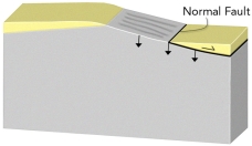
A) thicken the crust and cause subsidence
B) thicken the crust and cause uplift
C) thin the crust and cause subsidence
D) thin the crust and cause uplift
E) none of these
A) thicken the crust and cause subsidence
B) thicken the crust and cause uplift
C) thin the crust and cause subsidence
D) thin the crust and cause uplift
E) none of these
Question
Question
Question
If you had this type of deformation of a region, it would: 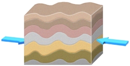
A) thicken the crust and cause subsidence
B) thicken the crust and cause uplift
C) thin the crust and cause subsidence
D) thin the crust and cause uplift
E) none of these
A) thicken the crust and cause subsidence
B) thicken the crust and cause uplift
C) thin the crust and cause subsidence
D) thin the crust and cause uplift
E) none of these
Question
Question
Question
Question
Question
If you had this type of deformation of a region, it would: 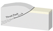
A) thicken the crust and cause subsidence
B) thicken the crust and cause uplift
C) thin the crust and cause subsidence
D) thin the crust and cause uplift
E) none of these
A) thicken the crust and cause subsidence
B) thicken the crust and cause uplift
C) thin the crust and cause subsidence
D) thin the crust and cause uplift
E) none of these
Question
Question
Question
Question
Question
If you erode material off of a region, it would: 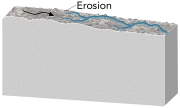
A) thicken the crust
B) thin the crust
C) cause the region to increase in elevation
D) none of these
A) thicken the crust
B) thin the crust
C) cause the region to increase in elevation
D) none of these
Question
Question
If you had this type of deformation of a region, it would: 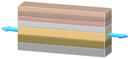
A) thicken the crust and cause subsidence
B) thicken the crust and cause uplift
C) thin the crust and cause subsidence
D) thin the crust and cause uplift
E) none of these
A) thicken the crust and cause subsidence
B) thicken the crust and cause uplift
C) thin the crust and cause subsidence
D) thin the crust and cause uplift
E) none of these
Question
Question
Question
Question
Using the rule of thumb for elevations and the information provided by the image, what may be said of the actual differences in elevation and crust thickness between Phoenix and Flagstaff Elevation Phoenix: 300 m, Flagstaff: 2100 m)? 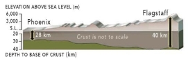
A) The differences are what we would predict. Rule of thumb: increase of 6 km crust thickness = increase in 1 km elevation.
B) The differences are what we would predict. Rule of thumb: increase of 1 km crust thickness = increase in 6 km elevation.
C) The differences are not what we would predict. Rule of thumb: increase of 1 km crust thickness = increase in 1 km elevation.
D) The differences are not what we would predict. Rule of thumb: increase of 6 km crust thickness = increase in 6 km elevation.
Question
Question
Why is there a basin associated with some thrust faults? 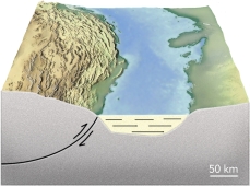
A) thrust faults thin the crust and cause subsidence
B) thrust faults form passive margins
C) thrust sheets depress the crust in front of the thrust
D) thrust sheets form a continent rift
A) thrust faults thin the crust and cause subsidence
B) thrust faults form passive margins
C) thrust sheets depress the crust in front of the thrust
D) thrust sheets form a continent rift
Question
Question
The image shows Stone Mountain in Georgia, a feature made of granite that was uncovered by erosion that removed the overlying and flanking softer rocks. What is the best name for this feature? 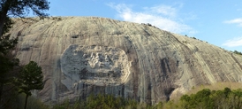
A) An erosional remnant
B) A mesa
C) A thrust fault
D) An anticline
A) An erosional remnant
B) A mesa
C) A thrust fault
D) An anticline
Question
Which of these regions is high because of mantle upwelling near a continental rift? 
A) 1, Andes of South America
B) 2, East Africa
C) 3, Tibet
D) none of these
A) 1, Andes of South America
B) 2, East Africa
C) 3, Tibet
D) none of these
Question
A continental shelf along a passive margin is below sea level because: 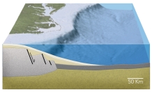
A) it is underlain by oceanic crust
B) it was a mountain that was eroded away
C) the crust has been thinned by normal faulting
D) the weight of the continental crust pushes it down
A) it is underlain by oceanic crust
B) it was a mountain that was eroded away
C) the crust has been thinned by normal faulting
D) the weight of the continental crust pushes it down
Question
Which of these regions is high because of a continental collision? 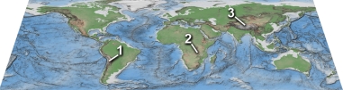
A) 1, Andes of South America
B) 2, East Africa Rift
C) 3, Tibet
D) none of these
A) 1, Andes of South America
B) 2, East Africa Rift
C) 3, Tibet
D) none of these
Question
Question
What type of basin is shown in this figure? 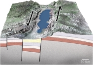
A) passive margin
B) normal-fault basin
C) foreland basin
D) basin along a strike-slip fault
A) passive margin
B) normal-fault basin
C) foreland basin
D) basin along a strike-slip fault
Question
Question
Question
Which of the following regions below would you predict to have the thickest continental crust? 
A) the West Coast because it is close to the plate boundary
B) the Colorado Rockies and adjacent Great Plains
C) the area with thick sediments around the Mississippi River
D) the Appalachian Mountains, the dominant range in the eastern U.S.
E) the East Coast because it is a passive margin
A) the West Coast because it is close to the plate boundary
B) the Colorado Rockies and adjacent Great Plains
C) the area with thick sediments around the Mississippi River
D) the Appalachian Mountains, the dominant range in the eastern U.S.
E) the East Coast because it is a passive margin
Question
Question
Question
Which of these regions is high because of subduction of an oceanic plate? 
A) 1, Andes of South America
B) 2, East Africa
C) 3, Tibet
D) none of these
A) 1, Andes of South America
B) 2, East Africa
C) 3, Tibet
D) none of these
Question
Question
Which of these numbered features is a foreland basin? 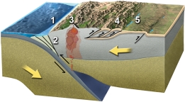
A) 1
B) 2
C) 3
D) 4
E) 5
A) 1
B) 2
C) 3
D) 4
E) 5
Question
Question
Question
What will happen during movement on these normal faults? 
A) the crust will thicken and the region will be uplifted
B) the crust will thin and the region will be uplifted
C) the fault blocks will rotate in the same direction, like books sliding on a shelf
D) the blocks will be uplifted or downdropped with only minor rotation
A) the crust will thicken and the region will be uplifted
B) the crust will thin and the region will be uplifted
C) the fault blocks will rotate in the same direction, like books sliding on a shelf
D) the blocks will be uplifted or downdropped with only minor rotation
Question
Question
Question
Question
Question
Which of these numbered features is a fold and thrust belt? 
A) 1
B) 2
C) 3
D) 4
E) 5
A) 1
B) 2
C) 3
D) 4
E) 5
Question
In the region shown in this figure, what is the most likely cause for a basin between the arc and continent? 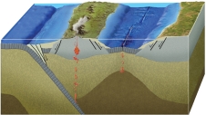
A) it is a foreland basin
B) it is an accretionary prism
C) it formed by back-arc rifting and spreading
D) it formed by strike-slip motion during a continental collision
A) it is a foreland basin
B) it is an accretionary prism
C) it formed by back-arc rifting and spreading
D) it formed by strike-slip motion during a continental collision
Question
The Michigan Basin is pictured in the images yellow and green are the youngest layers). What may be said of this basin? 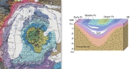
A) Rock layers form a bulls-eye pattern with the youngest rocks in the center, indicating the presence of the basin.
B) Layers are thicker in the center of the basin, indicating the basin was subsiding during deposition.
C) May have formed during an episode of continental rifting.
D) All of these may be said of the Michigan Basin.
Question
Which of these numbered features is an accretionary prism? 
A) 1
B) 2
C) 3
D) 4
E) 5
A) 1
B) 2
C) 3
D) 4
E) 5
Question
Question
Question
What will happen during movement on these normal faults? 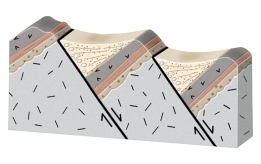
A) the crust will thicken and the region will be uplifted
B) the crust will thin and the region will be uplifted
C) the fault blocks will rotate in the same direction, like books sliding on a shelf
D) the blocks will be uplifted or downdropped with only minor rotation
A) the crust will thicken and the region will be uplifted
B) the crust will thin and the region will be uplifted
C) the fault blocks will rotate in the same direction, like books sliding on a shelf
D) the blocks will be uplifted or downdropped with only minor rotation
Question
Question
Question
Question
Question
Question
Question
Question
Which feature is interpreted to be in the Yellowstone region 1)? 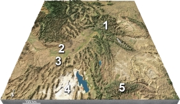
A) a continental collision
B) a meteorite impact
C) a continental hot spot
D) a foreland basin
A) a continental collision
B) a meteorite impact
C) a continental hot spot
D) a foreland basin
Question
Which numbered site is likely to have a thin sequence of sediments over crystalline rocks of the basement? 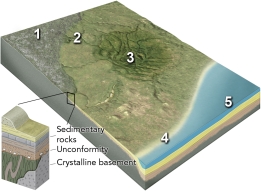
A) 1, the continental shield
B) 2, the continental platform
C) 3, a basin in the continent
D) 4, a continental shelf
E) 5, a deep sediment-filled basin next to the continent
A) 1, the continental shield
B) 2, the continental platform
C) 3, a basin in the continent
D) 4, a continental shelf
E) 5, a deep sediment-filled basin next to the continent
Question
Question
The basin shown in this figure was actively subsiding during the formation of unit: 
A) A
B) B
C) C
D) D
E) E
A) A
B) B
C) C
D) D
E) E
Question
Which of the following happened to form the features in this region? 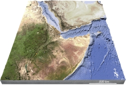
A) formation of a continental hot spot
B) continental rifting
C) seafloor spreading
D) volcanism that produced new land
E) all of these
A) formation of a continental hot spot
B) continental rifting
C) seafloor spreading
D) volcanism that produced new land
E) all of these
Question
Question
Which numbered site is likely to have exposure of crystalline rocks? 
A) 1, the continental shield
B) 2, the continental platform
C) 3, a basin in the continent
D) 4, a continental shelf
E) 5, a deep sediment-filled basin next to the continent
A) 1, the continental shield
B) 2, the continental platform
C) 3, a basin in the continent
D) 4, a continental shelf
E) 5, a deep sediment-filled basin next to the continent
Question
Question
Question
Question
Question
What is the timing of the basin shown in this figure? 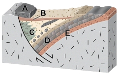
A) it was still forming during the eruption of volcanic unit A
B) it began forming during deposition of unit E
C) it began forming during deposition of unit D
D) both a and b
E) none of these
A) it was still forming during the eruption of volcanic unit A
B) it began forming during deposition of unit E
C) it began forming during deposition of unit D
D) both a and b
E) none of these
Question
Question
On this map of the area around Yellowstone, which feature is interpreted to record the position of the hot spot over time? 
A) 2, the Snake River Plain
B) 3, the Uinta Mountains
C) 4, the Bonneville Salt Flats
D) all of these
A) 2, the Snake River Plain
B) 3, the Uinta Mountains
C) 4, the Bonneville Salt Flats
D) all of these
Question
Question
Question
Question

Unlock Deck
Sign up to unlock the cards in this deck!
Unlock Deck
Unlock Deck
1/124
Play
Full screen (f)
Deck 11: Mountains, Basins, and Continents
1
Regional elevation can be decreased by:
A) normal faulting that thins the crust
B) erosion
C) cooling of the crust
D) all of these
A) normal faulting that thins the crust
B) erosion
C) cooling of the crust
D) all of these
D
2
In which of the following environments is the lithosphere likely to be thinnest?
A) beneath a mid-ocean ridge
B) beneath a typical part of the abyssal plain
C) a tectonically active continental margin
D) the interior of a continent away from plate boundaries
A) beneath a mid-ocean ridge
B) beneath a typical part of the abyssal plain
C) a tectonically active continental margin
D) the interior of a continent away from plate boundaries
A
3
The principle of isostasy was discovered by observing:
A) wooden blocks floating in a tank
B) icebergs of various sizes floating in the ocean
C) discrepancies in measurements made by surveyors in India
A) wooden blocks floating in a tank
B) icebergs of various sizes floating in the ocean
C) discrepancies in measurements made by surveyors in India
C
4
How can we tell that the Himalaya has been uplifted?
A) uplift can be measured with a global positioning system GPS)
B) deep rocks are exposed at the surface and yield young isotopic ages
C) the top of Mount Everest contains a limestone with marine fossils
D) all of these
A) uplift can be measured with a global positioning system GPS)
B) deep rocks are exposed at the surface and yield young isotopic ages
C) the top of Mount Everest contains a limestone with marine fossils
D) all of these
Unlock Deck
Unlock for access to all 124 flashcards in this deck.
Unlock Deck
k this deck
5
If you had this type of deformation of a region, it would:
A) thicken the crust and cause subsidence
B) thicken the crust and cause uplift
C) thin the crust and cause subsidence
D) thin the crust and cause uplift
E) none of these
A) thicken the crust and cause subsidence
B) thicken the crust and cause uplift
C) thin the crust and cause subsidence
D) thin the crust and cause uplift
E) none of these
Unlock Deck
Unlock for access to all 124 flashcards in this deck.
Unlock Deck
k this deck
6
Which of the following may affect crustal thickness?
A) Type of crust continental or oceanic)
B) Deformation like compression or stretching)
C) Erosion
D) Deposition or burial by volcanic rocks
E) All of these affect crustal thickness
A) Type of crust continental or oceanic)
B) Deformation like compression or stretching)
C) Erosion
D) Deposition or burial by volcanic rocks
E) All of these affect crustal thickness
Unlock Deck
Unlock for access to all 124 flashcards in this deck.
Unlock Deck
k this deck
7
Which of the following will be accompanied by a decrease in elevation?
A) gaining crustal material, such as by deposition
B) moving from oceanic crust to continental crust
C) compressing the crust from the sides
D) increasing the thickness of the lithosphere
A) gaining crustal material, such as by deposition
B) moving from oceanic crust to continental crust
C) compressing the crust from the sides
D) increasing the thickness of the lithosphere
Unlock Deck
Unlock for access to all 124 flashcards in this deck.
Unlock Deck
k this deck
8
If you had this type of deformation of a region, it would:
A) thicken the crust and cause subsidence
B) thicken the crust and cause uplift
C) thin the crust and cause subsidence
D) thin the crust and cause uplift
E) none of these
A) thicken the crust and cause subsidence
B) thicken the crust and cause uplift
C) thin the crust and cause subsidence
D) thin the crust and cause uplift
E) none of these
Unlock Deck
Unlock for access to all 124 flashcards in this deck.
Unlock Deck
k this deck
9
The average thickness of continental crust is:
A) 30-50 km
B) 10-20 km
C) 100 km
D) 150 km
A) 30-50 km
B) 10-20 km
C) 100 km
D) 150 km
Unlock Deck
Unlock for access to all 124 flashcards in this deck.
Unlock Deck
k this deck
10
Which of the following processes/situations may alter regional land elevation?
A) Intrusions of magma
B) Thrust faulting or normal faulting
C) Erosion or deposition
D) Heating or cooling
E) All of these processes/situations can alter regional land elevation
A) Intrusions of magma
B) Thrust faulting or normal faulting
C) Erosion or deposition
D) Heating or cooling
E) All of these processes/situations can alter regional land elevation
Unlock Deck
Unlock for access to all 124 flashcards in this deck.
Unlock Deck
k this deck
11
Regional elevation can be increased by:
A) thinning the crust
B) normal faulting
C) eroding material from the top
D) heating the crust and mantle
A) thinning the crust
B) normal faulting
C) eroding material from the top
D) heating the crust and mantle
Unlock Deck
Unlock for access to all 124 flashcards in this deck.
Unlock Deck
k this deck
12
Regional elevations on land are primarily controlled by:
A) the temperature of the crust
B) whether the crust is old or was formed more recently
C) whether the area is over a hot spot
D) the thickness of continental crust
A) the temperature of the crust
B) whether the crust is old or was formed more recently
C) whether the area is over a hot spot
D) the thickness of continental crust
Unlock Deck
Unlock for access to all 124 flashcards in this deck.
Unlock Deck
k this deck
13
If you had this type of deformation of a region, it would:
A) thicken the crust and cause subsidence
B) thicken the crust and cause uplift
C) thin the crust and cause subsidence
D) thin the crust and cause uplift
E) none of these
A) thicken the crust and cause subsidence
B) thicken the crust and cause uplift
C) thin the crust and cause subsidence
D) thin the crust and cause uplift
E) none of these
Unlock Deck
Unlock for access to all 124 flashcards in this deck.
Unlock Deck
k this deck
14
The average thickness of oceanic crust is:
A) 7 km
B) 5 km
C) 50 km
D) 12 km
A) 7 km
B) 5 km
C) 50 km
D) 12 km
Unlock Deck
Unlock for access to all 124 flashcards in this deck.
Unlock Deck
k this deck
15
Which of the following control the regional elevation of the land?
A) Thickness of the crust
B) Density of materials in the crust
C) Temperature of the crust and mantle
D) All of these can control regional elevation of the land
A) Thickness of the crust
B) Density of materials in the crust
C) Temperature of the crust and mantle
D) All of these can control regional elevation of the land
Unlock Deck
Unlock for access to all 124 flashcards in this deck.
Unlock Deck
k this deck
16
Regional elevation can be increased by:
A) thrust faulting that thickens the crust
B) constructing huge volcanic fields
C) adding a significant amount of magma at depth
D) heating a region's crust and mantle
E) all of these
A) thrust faulting that thickens the crust
B) constructing huge volcanic fields
C) adding a significant amount of magma at depth
D) heating a region's crust and mantle
E) all of these
Unlock Deck
Unlock for access to all 124 flashcards in this deck.
Unlock Deck
k this deck
17
What could cause a region to be higher in elevation than an average part of a continent?
A) thinner continental crust
B) less dense continental crust
C) cooler continental crust
D) crust that has been horizontally stretched
A) thinner continental crust
B) less dense continental crust
C) cooler continental crust
D) crust that has been horizontally stretched
Unlock Deck
Unlock for access to all 124 flashcards in this deck.
Unlock Deck
k this deck
18
If you erode material off of a region, it would:
A) thicken the crust
B) thin the crust
C) cause the region to increase in elevation
D) none of these
A) thicken the crust
B) thin the crust
C) cause the region to increase in elevation
D) none of these
Unlock Deck
Unlock for access to all 124 flashcards in this deck.
Unlock Deck
k this deck
19
The Himalaya are:
A) the highest mountain range in the world and contain Earth's highest peak
B) near the Colorado Plateau, one of the world's largest plateaus
C) underlain by abnormally thin lithosphere
D) an ancient mountain range with most uplift occurring 200 million years ago
E) all of these
A) the highest mountain range in the world and contain Earth's highest peak
B) near the Colorado Plateau, one of the world's largest plateaus
C) underlain by abnormally thin lithosphere
D) an ancient mountain range with most uplift occurring 200 million years ago
E) all of these
Unlock Deck
Unlock for access to all 124 flashcards in this deck.
Unlock Deck
k this deck
20
If you had this type of deformation of a region, it would:
A) thicken the crust and cause subsidence
B) thicken the crust and cause uplift
C) thin the crust and cause subsidence
D) thin the crust and cause uplift
E) none of these
A) thicken the crust and cause subsidence
B) thicken the crust and cause uplift
C) thin the crust and cause subsidence
D) thin the crust and cause uplift
E) none of these
Unlock Deck
Unlock for access to all 124 flashcards in this deck.
Unlock Deck
k this deck
21
The principle that regional elevations adjust to the types and thicknesses of rocks at depth is known as:
A) isostasy
B) superposition
C) elastic rebound
D) equanimity
A) isostasy
B) superposition
C) elastic rebound
D) equanimity
Unlock Deck
Unlock for access to all 124 flashcards in this deck.
Unlock Deck
k this deck
22
What is true of regional elevations across North America?
A) Elevations tend to be higher toward the west and decrease toward the east.
B) Elevations are highest in the Appalachian Mountains.
C) Elevations are lowest in the Great Plains.
D) Elevations do not change, when progressing from west to east.
A) Elevations tend to be higher toward the west and decrease toward the east.
B) Elevations are highest in the Appalachian Mountains.
C) Elevations are lowest in the Great Plains.
D) Elevations do not change, when progressing from west to east.
Unlock Deck
Unlock for access to all 124 flashcards in this deck.
Unlock Deck
k this deck
23
A mountain or hill that remains when adjacent areas have eroded to lower levels is an):
A) an erosional remnant
B) anticline
C) syncline
D) thrust fault
A) an erosional remnant
B) anticline
C) syncline
D) thrust fault
Unlock Deck
Unlock for access to all 124 flashcards in this deck.
Unlock Deck
k this deck
24
Using the rule of thumb for elevations and the information provided by the image, what may be said of the actual differences in elevation and crust thickness between Phoenix and Flagstaff Elevation Phoenix: 300 m, Flagstaff: 2100 m)?
A) The differences are what we would predict. Rule of thumb: increase of 6 km crust thickness = increase in 1 km elevation.
B) The differences are what we would predict. Rule of thumb: increase of 1 km crust thickness = increase in 6 km elevation.
C) The differences are not what we would predict. Rule of thumb: increase of 1 km crust thickness = increase in 1 km elevation.
D) The differences are not what we would predict. Rule of thumb: increase of 6 km crust thickness = increase in 6 km elevation.
Unlock Deck
Unlock for access to all 124 flashcards in this deck.
Unlock Deck
k this deck
25
Uplifting caused by the removal of weight on top of the crust, as when an ice sheet melts away or when erosion strips material off the top of a thick crustal root of a mountain, is called:
A) isostatic rebound
B) elastic buoyancy
C) floating equilibrium
D) the iceberg principal
A) isostatic rebound
B) elastic buoyancy
C) floating equilibrium
D) the iceberg principal
Unlock Deck
Unlock for access to all 124 flashcards in this deck.
Unlock Deck
k this deck
26
Why is there a basin associated with some thrust faults?
A) thrust faults thin the crust and cause subsidence
B) thrust faults form passive margins
C) thrust sheets depress the crust in front of the thrust
D) thrust sheets form a continent rift
A) thrust faults thin the crust and cause subsidence
B) thrust faults form passive margins
C) thrust sheets depress the crust in front of the thrust
D) thrust sheets form a continent rift
Unlock Deck
Unlock for access to all 124 flashcards in this deck.
Unlock Deck
k this deck
27
Which of the following are tectonic settings in which regional mountain belts form?
A) subduction zones
B) continental collisions
C) mantle upwellings
D) all of these
A) subduction zones
B) continental collisions
C) mantle upwellings
D) all of these
Unlock Deck
Unlock for access to all 124 flashcards in this deck.
Unlock Deck
k this deck
28
The image shows Stone Mountain in Georgia, a feature made of granite that was uncovered by erosion that removed the overlying and flanking softer rocks. What is the best name for this feature?
A) An erosional remnant
B) A mesa
C) A thrust fault
D) An anticline
A) An erosional remnant
B) A mesa
C) A thrust fault
D) An anticline
Unlock Deck
Unlock for access to all 124 flashcards in this deck.
Unlock Deck
k this deck
29
Which of these regions is high because of mantle upwelling near a continental rift?
A) 1, Andes of South America
B) 2, East Africa
C) 3, Tibet
D) none of these
A) 1, Andes of South America
B) 2, East Africa
C) 3, Tibet
D) none of these
Unlock Deck
Unlock for access to all 124 flashcards in this deck.
Unlock Deck
k this deck
30
A continental shelf along a passive margin is below sea level because:
A) it is underlain by oceanic crust
B) it was a mountain that was eroded away
C) the crust has been thinned by normal faulting
D) the weight of the continental crust pushes it down
A) it is underlain by oceanic crust
B) it was a mountain that was eroded away
C) the crust has been thinned by normal faulting
D) the weight of the continental crust pushes it down
Unlock Deck
Unlock for access to all 124 flashcards in this deck.
Unlock Deck
k this deck
31
Which of these regions is high because of a continental collision?
A) 1, Andes of South America
B) 2, East Africa Rift
C) 3, Tibet
D) none of these
A) 1, Andes of South America
B) 2, East Africa Rift
C) 3, Tibet
D) none of these
Unlock Deck
Unlock for access to all 124 flashcards in this deck.
Unlock Deck
k this deck
32
A local mountain created by volcanism:
A) may be high in elevation but is not accompanied by a regional increase in crustal thickness
B) is always accompanied by a regional increase in crustal thickness
C) is always low in elevation and therefore has no need for increase in crustal thickness
D) cannot be a shield-type volcano
A) may be high in elevation but is not accompanied by a regional increase in crustal thickness
B) is always accompanied by a regional increase in crustal thickness
C) is always low in elevation and therefore has no need for increase in crustal thickness
D) cannot be a shield-type volcano
Unlock Deck
Unlock for access to all 124 flashcards in this deck.
Unlock Deck
k this deck
33
What type of basin is shown in this figure?
A) passive margin
B) normal-fault basin
C) foreland basin
D) basin along a strike-slip fault
A) passive margin
B) normal-fault basin
C) foreland basin
D) basin along a strike-slip fault
Unlock Deck
Unlock for access to all 124 flashcards in this deck.
Unlock Deck
k this deck
34
Which of the following is NOT a setting in which regional mountain belts form?
A) continental collision
B) subduction zone
C) upwelling of the mantle
D) passive margin
E) the collision of India with Asia
A) continental collision
B) subduction zone
C) upwelling of the mantle
D) passive margin
E) the collision of India with Asia
Unlock Deck
Unlock for access to all 124 flashcards in this deck.
Unlock Deck
k this deck
35
Which of the following occurs when mountain belts are eroded?
A) erosion is accompanied by isostatic rebound
B) the continental crust becomes thinner
C) deep metamorphic and plutonic rocks can be uplifted to the surface
D) all of these
A) erosion is accompanied by isostatic rebound
B) the continental crust becomes thinner
C) deep metamorphic and plutonic rocks can be uplifted to the surface
D) all of these
Unlock Deck
Unlock for access to all 124 flashcards in this deck.
Unlock Deck
k this deck
36
Which of the following regions below would you predict to have the thickest continental crust?
A) the West Coast because it is close to the plate boundary
B) the Colorado Rockies and adjacent Great Plains
C) the area with thick sediments around the Mississippi River
D) the Appalachian Mountains, the dominant range in the eastern U.S.
E) the East Coast because it is a passive margin
A) the West Coast because it is close to the plate boundary
B) the Colorado Rockies and adjacent Great Plains
C) the area with thick sediments around the Mississippi River
D) the Appalachian Mountains, the dominant range in the eastern U.S.
E) the East Coast because it is a passive margin
Unlock Deck
Unlock for access to all 124 flashcards in this deck.
Unlock Deck
k this deck
37
Which of the following is NOT a way in which local mountains can be built?
A) prolonged volcanism in composite volcanoes
B) thrust faulting
C) normal faulting
D) folding
E) all of these are ways to make local mountains
A) prolonged volcanism in composite volcanoes
B) thrust faulting
C) normal faulting
D) folding
E) all of these are ways to make local mountains
Unlock Deck
Unlock for access to all 124 flashcards in this deck.
Unlock Deck
k this deck
38
Volcanism creates mountains that are:
A) sometimes local and not accompanied by regional increases in crustal thickness
B) formed of piled volcanic material, such as scoria, ash, lava flows, debris flows, and mudslides
C) varied in size from small cinder cones to large shield and composite volcanoes
D) all of these are types of mountains created by volcanism
Unlock Deck
Unlock for access to all 124 flashcards in this deck.
Unlock Deck
k this deck
39
Which of these regions is high because of subduction of an oceanic plate?
A) 1, Andes of South America
B) 2, East Africa
C) 3, Tibet
D) none of these
A) 1, Andes of South America
B) 2, East Africa
C) 3, Tibet
D) none of these
Unlock Deck
Unlock for access to all 124 flashcards in this deck.
Unlock Deck
k this deck
40
Which of the following correctly matches the tectonic setting of a mountain belt with an example?
A) subduction zone - East Africa
B) continental collision - Andes Mountains
C) mantle upwelling - Tibet
D) all of these
E) none of these
A) subduction zone - East Africa
B) continental collision - Andes Mountains
C) mantle upwelling - Tibet
D) all of these
E) none of these
Unlock Deck
Unlock for access to all 124 flashcards in this deck.
Unlock Deck
k this deck
41
Which of these numbered features is a foreland basin?
A) 1
B) 2
C) 3
D) 4
E) 5
A) 1
B) 2
C) 3
D) 4
E) 5
Unlock Deck
Unlock for access to all 124 flashcards in this deck.
Unlock Deck
k this deck
42
Which of the following would cause uplift along an ocean-continent convergent margin?
A) thinning of the lithosphere above the subduction zone
B) addition of magmas into the crust from the subduction zone
C) formation of a fold and thrust belt
D) all of these
A) thinning of the lithosphere above the subduction zone
B) addition of magmas into the crust from the subduction zone
C) formation of a fold and thrust belt
D) all of these
Unlock Deck
Unlock for access to all 124 flashcards in this deck.
Unlock Deck
k this deck
43
What processes associated with mountain and basin formation may accompany ocean-continent convergence?
A) Formation of an oceanic trench
B) Creation of a fold and thrust belt
C) Development of a foreland basin
D) Thickening of the crust due to compression and the addition of volcanic rock
E) All of these
A) Formation of an oceanic trench
B) Creation of a fold and thrust belt
C) Development of a foreland basin
D) Thickening of the crust due to compression and the addition of volcanic rock
E) All of these
Unlock Deck
Unlock for access to all 124 flashcards in this deck.
Unlock Deck
k this deck
44
What will happen during movement on these normal faults?
A) the crust will thicken and the region will be uplifted
B) the crust will thin and the region will be uplifted
C) the fault blocks will rotate in the same direction, like books sliding on a shelf
D) the blocks will be uplifted or downdropped with only minor rotation
A) the crust will thicken and the region will be uplifted
B) the crust will thin and the region will be uplifted
C) the fault blocks will rotate in the same direction, like books sliding on a shelf
D) the blocks will be uplifted or downdropped with only minor rotation
Unlock Deck
Unlock for access to all 124 flashcards in this deck.
Unlock Deck
k this deck
45
A prism- or wedge-shaped, structurally complex zone of faults, folds, and mostly metamorphosed rocks that form along the upper parts of a subduction zone where sedimentary material and oceanic crust are scraped off the downgoing slab is called an):
A) accretionary prism
B) subduction wedge
C) foreland basin
D) passive margin
A) accretionary prism
B) subduction wedge
C) foreland basin
D) passive margin
Unlock Deck
Unlock for access to all 124 flashcards in this deck.
Unlock Deck
k this deck
46
An accretionary prism is:
A) a wedge-shaped zone of faults, folds, and metamorphosed rocks formed along the upper parts of a subduction zone as material is scraped off
B) an active volcanic arc created by the subduction of one slab of ocean-crust-capped lithosphere beneath another
C) a sedimentary basin formed between a mountain range and the continental interior
D) a triangular-shaped sedimentary structure that allows light to pass through it and into lower areas of the crust
Unlock Deck
Unlock for access to all 124 flashcards in this deck.
Unlock Deck
k this deck
47
What happens during movement along rotating fault blocks?
A) The corner of a block that is rotated down becomes a basin.
B) The layers within the blocks rotate, but the blocks themselves do not.
C) The layers and blocks rotate, but the faults do not rotate.
D) The crust is thickened by the compression.
E) None of these.
A) The corner of a block that is rotated down becomes a basin.
B) The layers within the blocks rotate, but the blocks themselves do not.
C) The layers and blocks rotate, but the faults do not rotate.
D) The crust is thickened by the compression.
E) None of these.
Unlock Deck
Unlock for access to all 124 flashcards in this deck.
Unlock Deck
k this deck
48
Which part of the United States has present-day basins or basins preserved in its older rocks?
A) Basin and Range province of the western U.S.
B) Gulf Coast region of the southern U.S.
C) Appalachian Mountains
D) center of the continent, such as Michigan
E) all of these
A) Basin and Range province of the western U.S.
B) Gulf Coast region of the southern U.S.
C) Appalachian Mountains
D) center of the continent, such as Michigan
E) all of these
Unlock Deck
Unlock for access to all 124 flashcards in this deck.
Unlock Deck
k this deck
49
Which of these numbered features is a fold and thrust belt?
A) 1
B) 2
C) 3
D) 4
E) 5
A) 1
B) 2
C) 3
D) 4
E) 5
Unlock Deck
Unlock for access to all 124 flashcards in this deck.
Unlock Deck
k this deck
50
In the region shown in this figure, what is the most likely cause for a basin between the arc and continent?
A) it is a foreland basin
B) it is an accretionary prism
C) it formed by back-arc rifting and spreading
D) it formed by strike-slip motion during a continental collision
A) it is a foreland basin
B) it is an accretionary prism
C) it formed by back-arc rifting and spreading
D) it formed by strike-slip motion during a continental collision
Unlock Deck
Unlock for access to all 124 flashcards in this deck.
Unlock Deck
k this deck
51
The Michigan Basin is pictured in the images yellow and green are the youngest layers). What may be said of this basin?
A) Rock layers form a bulls-eye pattern with the youngest rocks in the center, indicating the presence of the basin.
B) Layers are thicker in the center of the basin, indicating the basin was subsiding during deposition.
C) May have formed during an episode of continental rifting.
D) All of these may be said of the Michigan Basin.
Unlock Deck
Unlock for access to all 124 flashcards in this deck.
Unlock Deck
k this deck
52
Which of these numbered features is an accretionary prism?
A) 1
B) 2
C) 3
D) 4
E) 5
A) 1
B) 2
C) 3
D) 4
E) 5
Unlock Deck
Unlock for access to all 124 flashcards in this deck.
Unlock Deck
k this deck
53
Which of the following is NOT a tectonic setting in which a basin can form?
A) passive margin
B) in front of a fold and thrust belt
C) along a strike-slip fault
D) at high elevations
E) basins can form in all these settings
A) passive margin
B) in front of a fold and thrust belt
C) along a strike-slip fault
D) at high elevations
E) basins can form in all these settings
Unlock Deck
Unlock for access to all 124 flashcards in this deck.
Unlock Deck
k this deck
54
The largest type of basin forms as a continental margin that is not a plate boundary. This is called an):
A) passive margin
B) active margin
C) boundary margin
D) forearc basin
A) passive margin
B) active margin
C) boundary margin
D) forearc basin
Unlock Deck
Unlock for access to all 124 flashcards in this deck.
Unlock Deck
k this deck
55
What will happen during movement on these normal faults?
A) the crust will thicken and the region will be uplifted
B) the crust will thin and the region will be uplifted
C) the fault blocks will rotate in the same direction, like books sliding on a shelf
D) the blocks will be uplifted or downdropped with only minor rotation
A) the crust will thicken and the region will be uplifted
B) the crust will thin and the region will be uplifted
C) the fault blocks will rotate in the same direction, like books sliding on a shelf
D) the blocks will be uplifted or downdropped with only minor rotation
Unlock Deck
Unlock for access to all 124 flashcards in this deck.
Unlock Deck
k this deck
56
What is the main cause of uplift during a continental collision?
A) down flexing of one continent in front of thrust belts
B) addition of magmas from the subduction zone
C) an almost doubling of the thickness of continental crust
D) thinning of the lithosphere
A) down flexing of one continent in front of thrust belts
B) addition of magmas from the subduction zone
C) an almost doubling of the thickness of continental crust
D) thinning of the lithosphere
Unlock Deck
Unlock for access to all 124 flashcards in this deck.
Unlock Deck
k this deck
57
What caused the site of the Catskill Delta in New York to become a basin?
A) rifting of the continent during the breakup of Pangaea
B) formation of a passive margin
C) a foreland basin formed by the weight of thrust sheets
D) down flexing of an oceanic plate during the start of subduction
A) rifting of the continent during the breakup of Pangaea
B) formation of a passive margin
C) a foreland basin formed by the weight of thrust sheets
D) down flexing of an oceanic plate during the start of subduction
Unlock Deck
Unlock for access to all 124 flashcards in this deck.
Unlock Deck
k this deck
58
Subduction is not always accompanied by compression and thrust faulting in the overriding plate. This is especially true when:
A) the overriding plate is either not moving toward the subducted slab relative to the asthenosphere, or it is moving away
B) the overriding plate is moving toward the subducted slab relative to the asthenosphere
C) no magma is created by the subduction process
D) an accretionary prism has developed at the convergent plate boundary
Unlock Deck
Unlock for access to all 124 flashcards in this deck.
Unlock Deck
k this deck
59
Which of the following processes forms basins in an ocean-continent convergent boundary?
A) flexing and bending of the continental plate as it goes down into the subduction zone
B) flexing of the continent by weight of the thrust sheets
C) thinning of the lithosphere above the subduction zone
D) thickening of the crust by magmas from the subduction zone
A) flexing and bending of the continental plate as it goes down into the subduction zone
B) flexing of the continent by weight of the thrust sheets
C) thinning of the lithosphere above the subduction zone
D) thickening of the crust by magmas from the subduction zone
Unlock Deck
Unlock for access to all 124 flashcards in this deck.
Unlock Deck
k this deck
60
Basins may form:
A) as a result of normal faulting
B) on both oceanic and continental plates
C) along plate margins
D) all of these
A) as a result of normal faulting
B) on both oceanic and continental plates
C) along plate margins
D) all of these
Unlock Deck
Unlock for access to all 124 flashcards in this deck.
Unlock Deck
k this deck
61
Hot spots have helped define the outlines of the continents by:
A) shaping the boundaries along which continents separate, due to location of the rift arms
B) "welding" continents together due to rising magma bodies and eruptions of lava
C) melting the edges of continents away to form indentions along the coast
A) shaping the boundaries along which continents separate, due to location of the rift arms
B) "welding" continents together due to rising magma bodies and eruptions of lava
C) melting the edges of continents away to form indentions along the coast
Unlock Deck
Unlock for access to all 124 flashcards in this deck.
Unlock Deck
k this deck
62
Which of the following is NOT interpreted to be related to a continental hot spot?
A) Afar region of east Africa
B) high elevations of Tibet
C) Yellowstone
D) Snake River Plain of Idaho
E) all of these are related to a continental hot spot
A) Afar region of east Africa
B) high elevations of Tibet
C) Yellowstone
D) Snake River Plain of Idaho
E) all of these are related to a continental hot spot
Unlock Deck
Unlock for access to all 124 flashcards in this deck.
Unlock Deck
k this deck
63
Which feature is interpreted to be in the Yellowstone region 1)?
A) a continental collision
B) a meteorite impact
C) a continental hot spot
D) a foreland basin
A) a continental collision
B) a meteorite impact
C) a continental hot spot
D) a foreland basin
Unlock Deck
Unlock for access to all 124 flashcards in this deck.
Unlock Deck
k this deck
64
Which numbered site is likely to have a thin sequence of sediments over crystalline rocks of the basement?
A) 1, the continental shield
B) 2, the continental platform
C) 3, a basin in the continent
D) 4, a continental shelf
E) 5, a deep sediment-filled basin next to the continent
A) 1, the continental shield
B) 2, the continental platform
C) 3, a basin in the continent
D) 4, a continental shelf
E) 5, a deep sediment-filled basin next to the continent
Unlock Deck
Unlock for access to all 124 flashcards in this deck.
Unlock Deck
k this deck
65
What regional effects influence continental interiors?
A) rises and falls in sea level related to changes in global climate
B) stresses transmitted from distant plate boundaries and mountain belts
C) preexisting fault that can be activated by stresses, causing faulting and folding
D) all of these
A) rises and falls in sea level related to changes in global climate
B) stresses transmitted from distant plate boundaries and mountain belts
C) preexisting fault that can be activated by stresses, causing faulting and folding
D) all of these
Unlock Deck
Unlock for access to all 124 flashcards in this deck.
Unlock Deck
k this deck
66
The basin shown in this figure was actively subsiding during the formation of unit:
A) A
B) B
C) C
D) D
E) E
A) A
B) B
C) C
D) D
E) E
Unlock Deck
Unlock for access to all 124 flashcards in this deck.
Unlock Deck
k this deck
67
Which of the following happened to form the features in this region?
A) formation of a continental hot spot
B) continental rifting
C) seafloor spreading
D) volcanism that produced new land
E) all of these
A) formation of a continental hot spot
B) continental rifting
C) seafloor spreading
D) volcanism that produced new land
E) all of these
Unlock Deck
Unlock for access to all 124 flashcards in this deck.
Unlock Deck
k this deck
68
Two well-known regions of currently active continental hot spots are:
A) Afar Region in East Africa, and Yellowstone National Park in North America
B) Great Lakes in North America, and Great Dividing Range in Australia
C) Andes Mountains in South America, and the Cascade Range in North America
D) Antarctica and Greenland
A) Afar Region in East Africa, and Yellowstone National Park in North America
B) Great Lakes in North America, and Great Dividing Range in Australia
C) Andes Mountains in South America, and the Cascade Range in North America
D) Antarctica and Greenland
Unlock Deck
Unlock for access to all 124 flashcards in this deck.
Unlock Deck
k this deck
69
Which numbered site is likely to have exposure of crystalline rocks?
A) 1, the continental shield
B) 2, the continental platform
C) 3, a basin in the continent
D) 4, a continental shelf
E) 5, a deep sediment-filled basin next to the continent
A) 1, the continental shield
B) 2, the continental platform
C) 3, a basin in the continent
D) 4, a continental shelf
E) 5, a deep sediment-filled basin next to the continent
Unlock Deck
Unlock for access to all 124 flashcards in this deck.
Unlock Deck
k this deck
70
What can a continental hot spot lead to?
A) formation of a curved continental outline along two rifts
B) localization of a river and delta along the failed arm of the rift
C) a thick accumulation of basalts and other volcanic rocks
D) a region that is high in elevation relative to adjacent parts of the continent
E) all of these
A) formation of a curved continental outline along two rifts
B) localization of a river and delta along the failed arm of the rift
C) a thick accumulation of basalts and other volcanic rocks
D) a region that is high in elevation relative to adjacent parts of the continent
E) all of these
Unlock Deck
Unlock for access to all 124 flashcards in this deck.
Unlock Deck
k this deck
71
How did the Ural Mountains within the middle of the Eurasian plate form?
A) stresses from a distant plate boundary reactivated ancient faults
B) the continent is beginning to break apart along a line of hot spots
C) the area is presently a plate boundary
D) two continents collided, trapping the mountain within the new, larger continent
A) stresses from a distant plate boundary reactivated ancient faults
B) the continent is beginning to break apart along a line of hot spots
C) the area is presently a plate boundary
D) two continents collided, trapping the mountain within the new, larger continent
Unlock Deck
Unlock for access to all 124 flashcards in this deck.
Unlock Deck
k this deck
72
The Ural Mountains in central Russia are a mountain range in the middle of a continent. How did this happen?
A) Europe collided with Siberia 200-300 million years ago, forming a range in the center of the new continent as the landmasses joined.
B) A hot spot developed beneath central Russia 250 million years ago and subsequent volcanism created a mountain range.
C) Subduction along the eastern coast of Russia has created a volcanic range near the center of Eurasia.
Unlock Deck
Unlock for access to all 124 flashcards in this deck.
Unlock Deck
k this deck
73
Continental hot spots are typically marked by:
A) high elevations
B) abundant volcanism
C) continental rifting
D) all of these typically mark continental hot spots
A) high elevations
B) abundant volcanism
C) continental rifting
D) all of these typically mark continental hot spots
Unlock Deck
Unlock for access to all 124 flashcards in this deck.
Unlock Deck
k this deck
74
What is the timing of the basin shown in this figure?
A) it was still forming during the eruption of volcanic unit A
B) it began forming during deposition of unit E
C) it began forming during deposition of unit D
D) both a and b
E) none of these
A) it was still forming during the eruption of volcanic unit A
B) it began forming during deposition of unit E
C) it began forming during deposition of unit D
D) both a and b
E) none of these
Unlock Deck
Unlock for access to all 124 flashcards in this deck.
Unlock Deck
k this deck
75
What can occur during the evolution of a hot spot?
A) an initial period of subsidence as magmas rise from the mantle
B) formation of a fold and thrust belt
C) formation of rifts that radiate out from the hot spot
D) thickening of the crust beneath a passive margin
E) none of these
A) an initial period of subsidence as magmas rise from the mantle
B) formation of a fold and thrust belt
C) formation of rifts that radiate out from the hot spot
D) thickening of the crust beneath a passive margin
E) none of these
Unlock Deck
Unlock for access to all 124 flashcards in this deck.
Unlock Deck
k this deck
76
On this map of the area around Yellowstone, which feature is interpreted to record the position of the hot spot over time?
A) 2, the Snake River Plain
B) 3, the Uinta Mountains
C) 4, the Bonneville Salt Flats
D) all of these
A) 2, the Snake River Plain
B) 3, the Uinta Mountains
C) 4, the Bonneville Salt Flats
D) all of these
Unlock Deck
Unlock for access to all 124 flashcards in this deck.
Unlock Deck
k this deck
77
For a terrane to become attached to a continent, it typically:
A) enters a subduction zone, where it is scraped off the subducting plate and added to the continent
B) floats across the ocean until it becomes lodged against the coast of a continent
C) is welded to the continent through volcanic activity
D) must result from the development of a hot spot and continental rifting
Unlock Deck
Unlock for access to all 124 flashcards in this deck.
Unlock Deck
k this deck
78
The process of adding a terrane to another landmass is called:
A) accretion
B) rifting
C) subsidence
D) back-arc spreading
A) accretion
B) rifting
C) subsidence
D) back-arc spreading
Unlock Deck
Unlock for access to all 124 flashcards in this deck.
Unlock Deck
k this deck
79
Which of the following is a valid description of features within continental interiors?
A) The central region of a continent is called a shield and is a broad, basaltic volcano with gentle slopes.
B) The continental platform has nearly horizontal sedimentary rocks deposited on crystalline basement.
C) The oldest exposed rocks in a continent are usually along the coastline.
D) Broad domes and basins in continental interiors have nearly vertical beds around their flanks.
E) All of these.
Unlock Deck
Unlock for access to all 124 flashcards in this deck.
Unlock Deck
k this deck
80
In what sites can extension occur near a subduction zone?
A) in front of the arc
B) within the arc
C) behind the arc
D) all of these
E) none of these
A) in front of the arc
B) within the arc
C) behind the arc
D) all of these
E) none of these
Unlock Deck
Unlock for access to all 124 flashcards in this deck.
Unlock Deck
k this deck
Unlock Deck
Unlock for access to all 124 flashcards in this deck.


