Deck 7: Rivers and Flooding
Full screen (f)
Question
Question
Question
Question
Question
Question
Question
Question
Question
Question
Question
Question
Question
Question
Question
Question
Question
Question
Question
Question
Question
Question
Question
Question
Question
Answer the following question(s) using the information provided in the graph below.
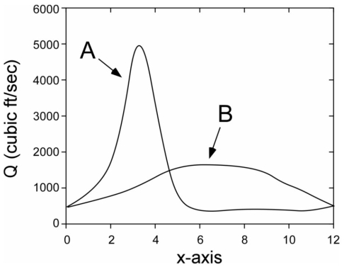
-The graph is a
A) rating curve.
B) flood frequency curve.
C) hydrograph.
D) urbanization graph.
E) longitudinal profile.
-The graph is a
A) rating curve.
B) flood frequency curve.
C) hydrograph.
D) urbanization graph.
E) longitudinal profile.
Question
Answer the following question(s) using the information provided in the graph below.
-What is Q on the y-axis of the graph?
A) discharge
B) intensity
C) elevation above sea level
D) time
E) soil content of the stream
-What is Q on the y-axis of the graph?
A) discharge
B) intensity
C) elevation above sea level
D) time
E) soil content of the stream
Question
Answer the following question(s) using the information provided in the graph below.
-What is x-axis of the graph?
A) discharge
B) intensity
C) elevation above sea level
D) time
E) soil content of the stream
-What is x-axis of the graph?
A) discharge
B) intensity
C) elevation above sea level
D) time
E) soil content of the stream
Question
Answer the following question(s) using the information provided in the graph below.
-Curve A best describes:
A) an oxbow lake.
B) flash flood (also called an upland flood).
C) a riverine flood (also called a lowland flood).
D) a drainage basin.
E) a bank-full flood.
-Curve A best describes:
A) an oxbow lake.
B) flash flood (also called an upland flood).
C) a riverine flood (also called a lowland flood).
D) a drainage basin.
E) a bank-full flood.
Question
Answer the following question(s) using the information provided in the graph below.
-Curve B best describes:
A) an oxbow lake.
B) flash flood (also called an upland flood).
C) a riverine flood (also called a lowland flood).
D) a drainage basin.
E) a bank-full flood.
-Curve B best describes:
A) an oxbow lake.
B) flash flood (also called an upland flood).
C) a riverine flood (also called a lowland flood).
D) a drainage basin.
E) a bank-full flood.
Question
Question
Question
Question
Question
Question
Question
Question
Question
Question
Question
Question
Question
Question
Question
Question

Unlock Deck
Sign up to unlock the cards in this deck!
Unlock Deck
Unlock Deck
1/45
Play
Full screen (f)
Deck 7: Rivers and Flooding
1
The boundaries between watersheds of all sizes are elevated areas called:
A) runoff.
B) tributaries.
C) divides.
D) trunk rivers.
E) channels.
A) runoff.
B) tributaries.
C) divides.
D) trunk rivers.
E) channels.
C
2
What is a river's base level?
A) the amount of water flowing in a river at any given time
B) the location in a river where water is continuously present and the main current flows
C) an area where surface runoff from rain flows together towards lower areas
D) where tributaries merge into a watershed's main river
E) the elevation where a river cannot flow further or erode deeper
E
3
What is the mathematical relationship between discharge, area, and velocity of a river?
A) discharge = area + velocity
B) discharge = area * velocity
C) area= discharge - velocity
D) area = discharge + velocity
E) discharge = (area * velocity)/70
A) discharge = area + velocity
B) discharge = area * velocity
C) area= discharge - velocity
D) area = discharge + velocity
E) discharge = (area * velocity)/70
B
4
What do we call a stream that has S-shaped curves?
A) meandering
B) alluvium
C) graded
D) linking
E) discharging
A) meandering
B) alluvium
C) graded
D) linking
E) discharging
Unlock Deck
Unlock for access to all 45 flashcards in this deck.
Unlock Deck
k this deck
5
The loss in elevation of a river channel is its:
A) gradient.
B) mouth.
C) base level.
D) cutbank.
E) watershed.
A) gradient.
B) mouth.
C) base level.
D) cutbank.
E) watershed.
Unlock Deck
Unlock for access to all 45 flashcards in this deck.
Unlock Deck
k this deck
6
Driving through flooded roads is ok to do in some situations.
Unlock Deck
Unlock for access to all 45 flashcards in this deck.
Unlock Deck
k this deck
7
Match the following options to its correct definition.
-saltation
A) process by which material is dragged, rolled, skipped, or bounced over the river bottom
B) location along a river where significant erosion can occur
C) water that flows into rivers when the ground is saturated
D) watershed's main river where tributaries merge
E) finer particles of material carried by a river
Unlock Deck
Unlock for access to all 45 flashcards in this deck.
Unlock Deck
k this deck
8
Match the following options to its correct definition.
-suspended load
A) process by which material is dragged, rolled, skipped, or bounced over the river bottom
B) location along a river where significant erosion can occur
C) water that flows into rivers when the ground is saturated
D) watershed's main river where tributaries merge
E) finer particles of material carried by a river
Unlock Deck
Unlock for access to all 45 flashcards in this deck.
Unlock Deck
k this deck
9
Match the following options to its correct definition.
-cutbank
A) process by which material is dragged, rolled, skipped, or bounced over the river bottom
B) location along a river where significant erosion can occur
C) water that flows into rivers when the ground is saturated
D) watershed's main river where tributaries merge
E) finer particles of material carried by a river
Unlock Deck
Unlock for access to all 45 flashcards in this deck.
Unlock Deck
k this deck
10
Match the following options to its correct definition.
-trunk
A) process by which material is dragged, rolled, skipped, or bounced over the river bottom
B) location along a river where significant erosion can occur
C) water that flows into rivers when the ground is saturated
D) watershed's main river where tributaries merge
E) finer particles of material carried by a river
Unlock Deck
Unlock for access to all 45 flashcards in this deck.
Unlock Deck
k this deck
11
Match the following options to its correct definition.
-runoff
A) process by which material is dragged, rolled, skipped, or bounced over the river bottom
B) location along a river where significant erosion can occur
C) water that flows into rivers when the ground is saturated
D) watershed's main river where tributaries merge
E) finer particles of material carried by a river
Unlock Deck
Unlock for access to all 45 flashcards in this deck.
Unlock Deck
k this deck
12
What does the "stage" of a river mean?
A) the volume of water in the river
B) how long the river is
C) how wide the river is
D) how high the river is
E) all of the above
A) the volume of water in the river
B) how long the river is
C) how wide the river is
D) how high the river is
E) all of the above
Unlock Deck
Unlock for access to all 45 flashcards in this deck.
Unlock Deck
k this deck
13
A natural levee is:
A) mounds of alluvium built up along the sides of a stream.
B) a type of dam.
C) an S-shaped river.
D) a lake created by a short cut in a meander.
E) a fan-shaped deposit.
A) mounds of alluvium built up along the sides of a stream.
B) a type of dam.
C) an S-shaped river.
D) a lake created by a short cut in a meander.
E) a fan-shaped deposit.
Unlock Deck
Unlock for access to all 45 flashcards in this deck.
Unlock Deck
k this deck
14
What factor is NOT important when determining if a river will flood?
A) the intensity of precipitation
B) how fast a river flows
C) the timing of when precipitation occurs
D) the type of soil or rock that river flows through
E) the duration of precipitation
A) the intensity of precipitation
B) how fast a river flows
C) the timing of when precipitation occurs
D) the type of soil or rock that river flows through
E) the duration of precipitation
Unlock Deck
Unlock for access to all 45 flashcards in this deck.
Unlock Deck
k this deck
15
We plot the loss of elevation of a river on a graph called a:
A) cross sectional profile.
B) longitudinal profile.
C) hydrograph.
D) flood frequency curve.
E) stage.
A) cross sectional profile.
B) longitudinal profile.
C) hydrograph.
D) flood frequency curve.
E) stage.
Unlock Deck
Unlock for access to all 45 flashcards in this deck.
Unlock Deck
k this deck
16
The bank-full stage of a river is lower than the flood-stage.
Unlock Deck
Unlock for access to all 45 flashcards in this deck.
Unlock Deck
k this deck
17
Hydrographs for flash floods look different than those for riverine floods.
Unlock Deck
Unlock for access to all 45 flashcards in this deck.
Unlock Deck
k this deck
18
Artificial levees on some rivers can be problematic for people living downstream along unprotected banks, who experience greater flooding than if the levees had not been built.
Unlock Deck
Unlock for access to all 45 flashcards in this deck.
Unlock Deck
k this deck
19
The National Flood Insurance Act provides federally subsidized insurance protection to property owners who live in flood-prone areas.
Unlock Deck
Unlock for access to all 45 flashcards in this deck.
Unlock Deck
k this deck
20
Although dams can be used to prevent floods, they can negatively impact their ecological environment.
Unlock Deck
Unlock for access to all 45 flashcards in this deck.
Unlock Deck
k this deck
21
What is NOT true about ice jams?
A) They block river channels and cause flooding both upstream and downstream.
B) They decrease a river's cross section.
C) They are temporary features of a river.
D) They can be related to glaciers.
E) They do not contribute to flooding.
A) They block river channels and cause flooding both upstream and downstream.
B) They decrease a river's cross section.
C) They are temporary features of a river.
D) They can be related to glaciers.
E) They do not contribute to flooding.
Unlock Deck
Unlock for access to all 45 flashcards in this deck.
Unlock Deck
k this deck
22
What is a recurrence interval?
A) the year when a river floods
B) the distance between two tributaries
C) the entire historical record of flood events
D) the average time between past flood events of similar size
E) the highest level above flood stage
A) the year when a river floods
B) the distance between two tributaries
C) the entire historical record of flood events
D) the average time between past flood events of similar size
E) the highest level above flood stage
Unlock Deck
Unlock for access to all 45 flashcards in this deck.
Unlock Deck
k this deck
23
A river's highest ranking flood:
A) is the one that experienced the largest flood.
B) is the one located closest to base level.
C) is the one that occurred at the lowest stage.
D) occurs only in the winter months.
E) occurs when rainfall intensity is high.
A) is the one that experienced the largest flood.
B) is the one located closest to base level.
C) is the one that occurred at the lowest stage.
D) occurs only in the winter months.
E) occurs when rainfall intensity is high.
Unlock Deck
Unlock for access to all 45 flashcards in this deck.
Unlock Deck
k this deck
24
What is the mathematical relationship between recurrence interval (RI) and rank (r) that involves time (T1 and T2)?
A) RI = [(r - T1) +1] * T2
B) RI = [(T2 - T1) +1]/r
C) RI = [(T1 - T2) + 1] * r
D) RI = [(T2 + T1) + 1] + r
E) RI = [(T2 + T1) - 1] - r
A) RI = [(r - T1) +1] * T2
B) RI = [(T2 - T1) +1]/r
C) RI = [(T1 - T2) + 1] * r
D) RI = [(T2 + T1) + 1] + r
E) RI = [(T2 + T1) - 1] - r
Unlock Deck
Unlock for access to all 45 flashcards in this deck.
Unlock Deck
k this deck
25
Answer the following question(s) using the information provided in the graph below.
-The graph is a
A) rating curve.
B) flood frequency curve.
C) hydrograph.
D) urbanization graph.
E) longitudinal profile.
-The graph is a
A) rating curve.
B) flood frequency curve.
C) hydrograph.
D) urbanization graph.
E) longitudinal profile.
Unlock Deck
Unlock for access to all 45 flashcards in this deck.
Unlock Deck
k this deck
26
Answer the following question(s) using the information provided in the graph below.
-What is Q on the y-axis of the graph?
A) discharge
B) intensity
C) elevation above sea level
D) time
E) soil content of the stream
-What is Q on the y-axis of the graph?
A) discharge
B) intensity
C) elevation above sea level
D) time
E) soil content of the stream
Unlock Deck
Unlock for access to all 45 flashcards in this deck.
Unlock Deck
k this deck
27
Answer the following question(s) using the information provided in the graph below.
-What is x-axis of the graph?
A) discharge
B) intensity
C) elevation above sea level
D) time
E) soil content of the stream
-What is x-axis of the graph?
A) discharge
B) intensity
C) elevation above sea level
D) time
E) soil content of the stream
Unlock Deck
Unlock for access to all 45 flashcards in this deck.
Unlock Deck
k this deck
28
Answer the following question(s) using the information provided in the graph below.
-Curve A best describes:
A) an oxbow lake.
B) flash flood (also called an upland flood).
C) a riverine flood (also called a lowland flood).
D) a drainage basin.
E) a bank-full flood.
-Curve A best describes:
A) an oxbow lake.
B) flash flood (also called an upland flood).
C) a riverine flood (also called a lowland flood).
D) a drainage basin.
E) a bank-full flood.
Unlock Deck
Unlock for access to all 45 flashcards in this deck.
Unlock Deck
k this deck
29
Answer the following question(s) using the information provided in the graph below.
-Curve B best describes:
A) an oxbow lake.
B) flash flood (also called an upland flood).
C) a riverine flood (also called a lowland flood).
D) a drainage basin.
E) a bank-full flood.
-Curve B best describes:
A) an oxbow lake.
B) flash flood (also called an upland flood).
C) a riverine flood (also called a lowland flood).
D) a drainage basin.
E) a bank-full flood.
Unlock Deck
Unlock for access to all 45 flashcards in this deck.
Unlock Deck
k this deck
30
What is NOT true about the 100-year flood?
A) It is commonly used in communities located near rivers as a guide for planning decisions.
B) It is defined as the flood that has a 100 year recurrence interval.
C) Its estimated discharge can be calculated using a graph called a rating curve.
D) It is a flood that occurs every 50 years.
E) It has a 1 in 100 chance of occurring.
Unlock Deck
Unlock for access to all 45 flashcards in this deck.
Unlock Deck
k this deck
31
The probability that a 100 year flood will occur on any given river this year is:
A) 0.001%.
B) 0.01%.
C) 1%.
D) 10%.
E) 100%.
A) 0.001%.
B) 0.01%.
C) 1%.
D) 10%.
E) 100%.
Unlock Deck
Unlock for access to all 45 flashcards in this deck.
Unlock Deck
k this deck
32
Engineers can physically restructure rivers to reduce probability of flooding by:
A) decreasing a river's discharge.
B) increase a channel's cross sectional area.
C) allowing a river's flow velocity to increase in response to increase discharge.
D) building dams.
E) all of the above.
A) decreasing a river's discharge.
B) increase a channel's cross sectional area.
C) allowing a river's flow velocity to increase in response to increase discharge.
D) building dams.
E) all of the above.
Unlock Deck
Unlock for access to all 45 flashcards in this deck.
Unlock Deck
k this deck
33
Match the following options to its correct definition.
-diversion channels
A) structures that increases the level to which a river can rise before it overflows
B) a type of channel alteration that allows water to flow out of the channel at specific points where it will not be damaging
C) gates that open and move water away from major population centers during times of high river stage
D) locally constructed reservoirs that decrease the rate at which surface water runs into rivers
E) a structure built to store extra discharge from a river; can be used to generate power, create a recreational area, and control water levels for shipping
Unlock Deck
Unlock for access to all 45 flashcards in this deck.
Unlock Deck
k this deck
34
Match the following options to its correct definition.
-detention pond
A) structures that increases the level to which a river can rise before it overflows
B) a type of channel alteration that allows water to flow out of the channel at specific points where it will not be damaging
C) gates that open and move water away from major population centers during times of high river stage
D) locally constructed reservoirs that decrease the rate at which surface water runs into rivers
E) a structure built to store extra discharge from a river; can be used to generate power, create a recreational area, and control water levels for shipping
Unlock Deck
Unlock for access to all 45 flashcards in this deck.
Unlock Deck
k this deck
35
Match the following options to its correct definition.
-fuse-plug levee
A) structures that increases the level to which a river can rise before it overflows
B) a type of channel alteration that allows water to flow out of the channel at specific points where it will not be damaging
C) gates that open and move water away from major population centers during times of high river stage
D) locally constructed reservoirs that decrease the rate at which surface water runs into rivers
E) a structure built to store extra discharge from a river; can be used to generate power, create a recreational area, and control water levels for shipping
Unlock Deck
Unlock for access to all 45 flashcards in this deck.
Unlock Deck
k this deck
36
Match the following options to its correct definition.
-flood-control dam
A) structures that increases the level to which a river can rise before it overflows
B) a type of channel alteration that allows water to flow out of the channel at specific points where it will not be damaging
C) gates that open and move water away from major population centers during times of high river stage
D) locally constructed reservoirs that decrease the rate at which surface water runs into rivers
E) a structure built to store extra discharge from a river; can be used to generate power, create a recreational area, and control water levels for shipping
Unlock Deck
Unlock for access to all 45 flashcards in this deck.
Unlock Deck
k this deck
37
Match the following options to its correct definition.
-floodwalls
A) structures that increases the level to which a river can rise before it overflows
B) a type of channel alteration that allows water to flow out of the channel at specific points where it will not be damaging
C) gates that open and move water away from major population centers during times of high river stage
D) locally constructed reservoirs that decrease the rate at which surface water runs into rivers
E) a structure built to store extra discharge from a river; can be used to generate power, create a recreational area, and control water levels for shipping
Unlock Deck
Unlock for access to all 45 flashcards in this deck.
Unlock Deck
k this deck
38
What is a delta?
A) a general term given for sediment deposited by the river
B) the buildup of river sediments at the base of a mountain
C) forms when sediment-laden stream flows into standing water
D) a low area adjacent to a stream that is subject to flooding
E) where flowing water assumes a series of S-shaped curves
Unlock Deck
Unlock for access to all 45 flashcards in this deck.
Unlock Deck
k this deck
39
What is flash flood? What are other types of floods?
Unlock Deck
Unlock for access to all 45 flashcards in this deck.
Unlock Deck
k this deck
40
Discuss the relationship between flooding and (a) precipitation, (b) soil characteristics, and (c) vegetation. Why do floods occur?
Unlock Deck
Unlock for access to all 45 flashcards in this deck.
Unlock Deck
k this deck
41
Draw a meandering river and label the cut bank and point bar. Describe how this type of river can create an oxbow lake.
Unlock Deck
Unlock for access to all 45 flashcards in this deck.
Unlock Deck
k this deck
42
Describe two ways in which urbanization (city development) may increase local flood hazards.
Unlock Deck
Unlock for access to all 45 flashcards in this deck.
Unlock Deck
k this deck
43
How much water is safe to drive through? At what height can a flooded street become dangerous?
Unlock Deck
Unlock for access to all 45 flashcards in this deck.
Unlock Deck
k this deck
44
What are some ways that flood hazards can be reduced? As an engineering geologist, what can you do to prevent even minor floods at your construction site?
Unlock Deck
Unlock for access to all 45 flashcards in this deck.
Unlock Deck
k this deck
45
"Levee construction may reduce local flood hazards, but they may worsen flood hazards elsewhere along a stream." What is a levee? Do you agree with the statement? Explain.
Unlock Deck
Unlock for access to all 45 flashcards in this deck.
Unlock Deck
k this deck
Unlock Deck
Unlock for access to all 45 flashcards in this deck.


