Deck 4: Glacial and Arid Landscapes
Full screen (f)
Question
Question
Question
Question
Question
Question
Question
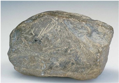
This cobble shows prominent scratches because ________.
A)it was tumbled in a stream
B)it was scraped against other rocks in a glacier
C)it was blasted by wind
D)this was its shape when it was mechanically weathered from its source rock
Question
Question
Question
Question
Which of the four lettered positions on this map-view sketch shows the location of the terminal end moraine?
A)A
B)B
C)C
D)D
Question
Question
Question
Question
Question
Question
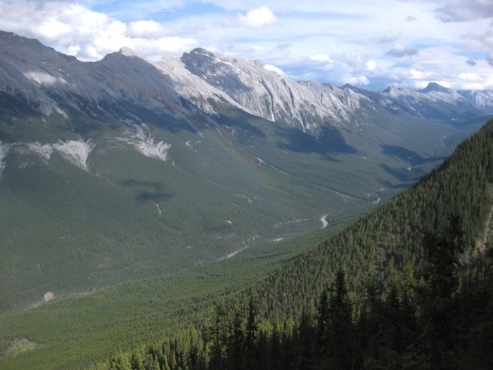
What formed this valley's distinctive "U" shape?
A)river erosion
B)wind erosion
C)dune movement
D)glacial erosion
Question
Question
Question
Question
Question
Question
Question
Question
Question
Question
Question
Question
Question
Question
Question
Question
Question
Question
Question
Question
Question
Question
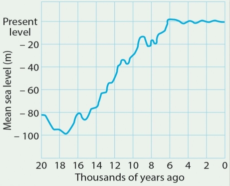
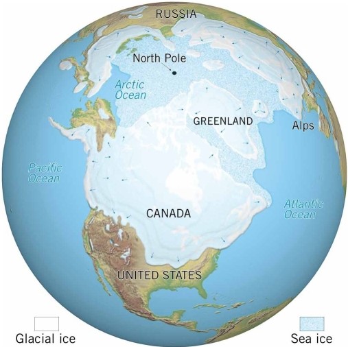
At the Last Glacial Maximum, sea level was about 180 meters lower than it is today.
Question
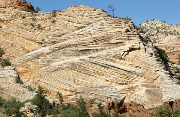
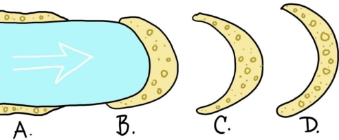
Examine the photo. Is it true or false to say, "the dunes that deposited these cross beds were moving from the left to the right"?
Question
Question
Question
Question
Question
Question
Question
Question
Question
The ________ region of the United States is depicted in this image.
Question
Question
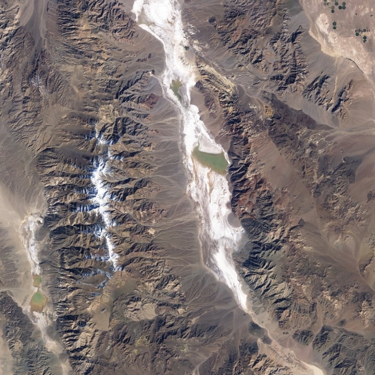
Examine the satellite image of Death Valley, California. (a)What province of the United States is it located within? (b)Identify the various desert landforms seen there, circle and label them, and (c)describe how each one forms. Finally, (d)describe the sequence of events to that produced this scene over time.
Question
Question
Question
Question
Question
Question
Question
Question
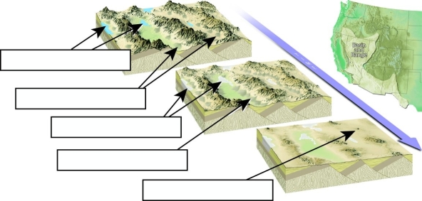
Label each of the indicated Basin and Range landscape features in the boxes provided.
Question
The ________ period of geologic time is depicted in this image.
Question
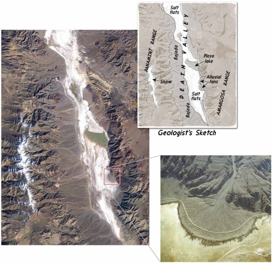
Examine the aerial photograph of Death Valley, California, part of the Basin and Range province. Note that the western side of Death Valley, up against the Panamint Range, features a well-developed bajada, while the east side of the valley, up against the Amargosa Range, shows only a few isolated alluvial fans. Suggest an explanation for this asymmetry, and how you would test your hypothesis with an investigation on the ground.
Question
Question
Match between columns

Unlock Deck
Sign up to unlock the cards in this deck!
Unlock Deck
Unlock Deck
1/63
Play
Full screen (f)
Deck 4: Glacial and Arid Landscapes
1
A glacier's downstream end ________.
A)is where new ice is added through compaction of snowfall
B)is in the zone of wastage
C)is where the fastest flow occurs
D)is where cirques get carved out
A)is where new ice is added through compaction of snowfall
B)is in the zone of wastage
C)is where the fastest flow occurs
D)is where cirques get carved out
B
2
In an area of alpine glaciation, sinuous, sharp-edged ridges called ________ and sharp, pyramid- like peaks called ________ are common features.
A)tarns; cirques
B)cirques; arêtes
C)arêtes; horns
D)horns; hanging valleys
A)tarns; cirques
B)cirques; arêtes
C)arêtes; horns
D)horns; hanging valleys
C
3
How do glaciers move?
A)They slide along their bottoms, over the bedrock beneath.
B)They flow internally, like Silly Putty.
C)Both A and B
D)Neither A nor B
A)They slide along their bottoms, over the bedrock beneath.
B)They flow internally, like Silly Putty.
C)Both A and B
D)Neither A nor B
C
4
When a valley glacier leaves the mountains and enters the relative flat lands below, it may spread out to form ________.
A)an ice cap
B)a piedmont glacier
C)an ice shelf
D)a lateral moraine
A)an ice cap
B)a piedmont glacier
C)an ice shelf
D)a lateral moraine
Unlock Deck
Unlock for access to all 63 flashcards in this deck.
Unlock Deck
k this deck
5
Under typical conditions, glaciers flow ________.
A)at a rate between 2 meters (6.5 feet)and 800 meters (2600 feet)per year
B)throughout the entire glacial ice mass
C)at a rate between 1.6 to 8 kilometers per hour (1 and 5 miles per hour)
D)only when the snow is falling
A)at a rate between 2 meters (6.5 feet)and 800 meters (2600 feet)per year
B)throughout the entire glacial ice mass
C)at a rate between 1.6 to 8 kilometers per hour (1 and 5 miles per hour)
D)only when the snow is falling
Unlock Deck
Unlock for access to all 63 flashcards in this deck.
Unlock Deck
k this deck
6
Which one of the following is NOT true of glaciers?
A)They originate on land.
B)They exist only in the Northern Hemisphere.
C)They show evidence of flow (either in the present or in the recent past).
D)They form from the recrystallization of snow.
A)They originate on land.
B)They exist only in the Northern Hemisphere.
C)They show evidence of flow (either in the present or in the recent past).
D)They form from the recrystallization of snow.
Unlock Deck
Unlock for access to all 63 flashcards in this deck.
Unlock Deck
k this deck
7
This cobble shows prominent scratches because ________.
A)it was tumbled in a stream
B)it was scraped against other rocks in a glacier
C)it was blasted by wind
D)this was its shape when it was mechanically weathered from its source rock
Unlock Deck
Unlock for access to all 63 flashcards in this deck.
Unlock Deck
k this deck
8
Which of the following lakes formed over an immense area of the northern United States and southern Canada during the Quaternary Ice Age?
A)Lake Agassiz
B)Lake Bonneville
C)Great Salt Lake
D)Walden Pond
A)Lake Agassiz
B)Lake Bonneville
C)Great Salt Lake
D)Walden Pond
Unlock Deck
Unlock for access to all 63 flashcards in this deck.
Unlock Deck
k this deck
9
________ are erosional features produced by valley (alpine)glaciers.
A)Moraines
B)Cirques
C)Eskers
D)Drumlins
A)Moraines
B)Cirques
C)Eskers
D)Drumlins
Unlock Deck
Unlock for access to all 63 flashcards in this deck.
Unlock Deck
k this deck
10
Where do crevasses form?
A)in the zone of fracture
B)below the zone of fracture
C)at the terminus
D)in icebergs
A)in the zone of fracture
B)below the zone of fracture
C)at the terminus
D)in icebergs
Unlock Deck
Unlock for access to all 63 flashcards in this deck.
Unlock Deck
k this deck
11
Which of the four lettered positions on this map-view sketch shows the location of the terminal end moraine?
A)A
B)B
C)C
D)D
Unlock Deck
Unlock for access to all 63 flashcards in this deck.
Unlock Deck
k this deck
12
Where are drumlins formed?
A)in areas of alpine glaciation
B)in areas of ground moraine
C)in fiords
D)in areas of glacial plucking
A)in areas of alpine glaciation
B)in areas of ground moraine
C)in fiords
D)in areas of glacial plucking
Unlock Deck
Unlock for access to all 63 flashcards in this deck.
Unlock Deck
k this deck
13
If accumulation exceeds ablation in a glacial budget, which of the following will happen?
A)The terminus will move downhill ("advance").
B)The terminus will shift uphill ("retreat").
C)The glacier will begin to flow uphill.
D)The glacier will melt away due to climate change.
A)The terminus will move downhill ("advance").
B)The terminus will shift uphill ("retreat").
C)The glacier will begin to flow uphill.
D)The glacier will melt away due to climate change.
Unlock Deck
Unlock for access to all 63 flashcards in this deck.
Unlock Deck
k this deck
14
About what percentage of Earth's land surface is covered by deserts?
A)3%
B)15%
C)30%
D)55%
A)3%
B)15%
C)30%
D)55%
Unlock Deck
Unlock for access to all 63 flashcards in this deck.
Unlock Deck
k this deck
15
How is desert different from steppe?
A)Steppe is more humid than desert.
B)Desert is more humid than steppe.
C)Desert occurs at subtropical latitudes, but not at mid-latitudes in continental interiors.
D)Steppe occurs at subtropical latitudes, but not at mid-latitudes in continental interiors.
A)Steppe is more humid than desert.
B)Desert is more humid than steppe.
C)Desert occurs at subtropical latitudes, but not at mid-latitudes in continental interiors.
D)Steppe occurs at subtropical latitudes, but not at mid-latitudes in continental interiors.
Unlock Deck
Unlock for access to all 63 flashcards in this deck.
Unlock Deck
k this deck
16
If you were on a geology field trip in an area of glacial deposition, how would you distinguish between samples of till and stratified drift?
A)with a rock hammer
B)by comparing their grain size and sorting
C)by comparing the specific gravity of the two samples
D)with hydrochloric acid
A)with a rock hammer
B)by comparing their grain size and sorting
C)by comparing the specific gravity of the two samples
D)with hydrochloric acid
Unlock Deck
Unlock for access to all 63 flashcards in this deck.
Unlock Deck
k this deck
17
What formed this valley's distinctive "U" shape?
A)river erosion
B)wind erosion
C)dune movement
D)glacial erosion
Unlock Deck
Unlock for access to all 63 flashcards in this deck.
Unlock Deck
k this deck
18
Where is the world's largest ice sheet located today?
A)Greenland
B)Alaska
C)Iceland
D)Antarctica
A)Greenland
B)Alaska
C)Iceland
D)Antarctica
Unlock Deck
Unlock for access to all 63 flashcards in this deck.
Unlock Deck
k this deck
19
About what percentage of Earth's land surface was covered by glaciers during the Quaternary period?
A)3%
B)15%
C)30%
D)55%
A)3%
B)15%
C)30%
D)55%
Unlock Deck
Unlock for access to all 63 flashcards in this deck.
Unlock Deck
k this deck
20
Which of the following is NOT a variety of moraine?
A)lateral
B)medial
C)end
D)hanging
A)lateral
B)medial
C)end
D)hanging
Unlock Deck
Unlock for access to all 63 flashcards in this deck.
Unlock Deck
k this deck
21
Cross-bedding consists of many preserved ________ resulting from moving sand dunes.
A)slip faces
B)desert pavements
C)blowouts
D)loess
A)slip faces
B)desert pavements
C)blowouts
D)loess
Unlock Deck
Unlock for access to all 63 flashcards in this deck.
Unlock Deck
k this deck
22
Glaciers acquire sediment through plucking from the bedrock beneath the glacier.
Unlock Deck
Unlock for access to all 63 flashcards in this deck.
Unlock Deck
k this deck
23
Arêtes, horns, and U-shaped valleys are depositional features made of till.
Unlock Deck
Unlock for access to all 63 flashcards in this deck.
Unlock Deck
k this deck
24
Glaciers are part of the hydrologic cycle.
Unlock Deck
Unlock for access to all 63 flashcards in this deck.
Unlock Deck
k this deck
25
Steppes are the driest of the true desert lands.
Unlock Deck
Unlock for access to all 63 flashcards in this deck.
Unlock Deck
k this deck
26
A rainshadow desert forms ________.
A)when dry air descends from high in the atmosphere between 20° and 30° latitude
B)in places where mountain ranges act as barriers to the movement of water vapor
C)in cold, polar regions
D)near the equator, where moist air rises (because it is hot and less dense)up, away from Earth's surface
A)when dry air descends from high in the atmosphere between 20° and 30° latitude
B)in places where mountain ranges act as barriers to the movement of water vapor
C)in cold, polar regions
D)near the equator, where moist air rises (because it is hot and less dense)up, away from Earth's surface
Unlock Deck
Unlock for access to all 63 flashcards in this deck.
Unlock Deck
k this deck
27
The most recent Ice Age occurred during the Cretaceous period.
Unlock Deck
Unlock for access to all 63 flashcards in this deck.
Unlock Deck
k this deck
28
Hanging valleys are glacier-cut valleys that flooded as sea level rose in post-glacial times.
Unlock Deck
Unlock for access to all 63 flashcards in this deck.
Unlock Deck
k this deck
29
Ephemeral streams ________.
A)are a major agent of erosion in desert regions
B)are a major agent of erosion in areas of ground moraine
C)flow all the time
D)are limited to rainshadow deserts
A)are a major agent of erosion in desert regions
B)are a major agent of erosion in areas of ground moraine
C)flow all the time
D)are limited to rainshadow deserts
Unlock Deck
Unlock for access to all 63 flashcards in this deck.
Unlock Deck
k this deck
30
Moraines are the only glacial deposits composed of till.
Unlock Deck
Unlock for access to all 63 flashcards in this deck.
Unlock Deck
k this deck
31
Deflation may lead to ________.
A)dust storms
B)desert pavement
C)loess
D)all of the above
A)dust storms
B)desert pavement
C)loess
D)all of the above
Unlock Deck
Unlock for access to all 63 flashcards in this deck.
Unlock Deck
k this deck
32
Till is unsorted sediment deposited directly from the melting glacial ice; stream action is not involved.
Unlock Deck
Unlock for access to all 63 flashcards in this deck.
Unlock Deck
k this deck
33
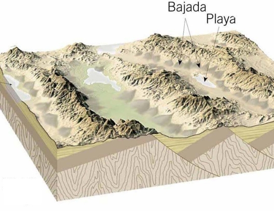
Bajadas develop when multiple alluvial fans grow and merge along the fronts of mountain ranges in arid lands.
Unlock Deck
Unlock for access to all 63 flashcards in this deck.
Unlock Deck
k this deck
34
Loess consists mainly of sand-sized particles.
Unlock Deck
Unlock for access to all 63 flashcards in this deck.
Unlock Deck
k this deck
35
Although infrequent, running water is responsible for most of the erosional work in deserts.
Unlock Deck
Unlock for access to all 63 flashcards in this deck.
Unlock Deck
k this deck
36
The Basin and Range region of the western United States is characterized by interior drainage with streams eroding uplifted mountain blocks and depositing sediment in interior basins.
Unlock Deck
Unlock for access to all 63 flashcards in this deck.
Unlock Deck
k this deck
37
Melting and calving are two forms of accumulation.
Unlock Deck
Unlock for access to all 63 flashcards in this deck.
Unlock Deck
k this deck
38
A(n)________ a thick, flowing ice mass that forms over hundreds or thousands of years.
Unlock Deck
Unlock for access to all 63 flashcards in this deck.
Unlock Deck
k this deck
39
At the Last Glacial Maximum, sea level was about 180 meters lower than it is today.
Unlock Deck
Unlock for access to all 63 flashcards in this deck.
Unlock Deck
k this deck
40
Examine the photo. Is it true or false to say, "the dunes that deposited these cross beds were moving from the left to the right"?
Unlock Deck
Unlock for access to all 63 flashcards in this deck.
Unlock Deck
k this deck
41
Match the items in the first column with the correct descriptions in the second column.
A)lifting and removal of loose material like soil or sediment by the wind.
B)wind-deposited sand that forms mounds or ridges.
C)a layer of coarse pebbles and cobbles that are too large to be moved by the wind overlying finer-grained sediment in desert regions.
D)preserved slip-faces that accumulate as a dune migrates.
E)shallow depressions where soil or sediment has been stripped away by the wind.
F)regions that are slightly more humid than desert.
G)wind-deposited silt.
H)the leeward side of a dune.
1)deflation
2)dunes
3)blowout
4)loess
5)slip face
6)cross-bedding
7)steppe
8)desert pavement
Unlock Deck
Unlock for access to all 63 flashcards in this deck.
Unlock Deck
k this deck
42
A landscape dominated by U-shaped valleys and pyramid-shaped mountains is most likely formed due to ________.
Unlock Deck
Unlock for access to all 63 flashcards in this deck.
Unlock Deck
k this deck
43
By the year 2030, it is possible that Glacier National Park in Montana will not have any ________.
Unlock Deck
Unlock for access to all 63 flashcards in this deck.
Unlock Deck
k this deck
44
________ is drier than steppe.
Unlock Deck
Unlock for access to all 63 flashcards in this deck.
Unlock Deck
k this deck
45
A hazard people face when crossing a glacier is falling into a(n)________, a large crack that extends through the zone of fracture.
Unlock Deck
Unlock for access to all 63 flashcards in this deck.
Unlock Deck
k this deck
46
Desert regions that exhibit a discontinuous pattern of ephemeral streams that do not flow out of the desert to the ocean are said to have a(n)________.
Unlock Deck
Unlock for access to all 63 flashcards in this deck.
Unlock Deck
k this deck
47
Between wind, water, and glacial ice, ________ is easily the least effective agent of erosion.
Unlock Deck
Unlock for access to all 63 flashcards in this deck.
Unlock Deck
k this deck
48
Match the items in the first column with the correct descriptions in the second column.
A)enormous mass of ice that flows out in all directions from one or more snow-accumulation centers and completely obscures all but the highest areas of underlying terrain.
B)a stream of ice, bounded by precipitous rock walls, that flows down a mountain valley from a snow accumulation center near its head.
C)frozen seawater.
D)large, relatively flat masses of floating ice that extend seaward from the coast (where they are fed by glaciers)but remain attached to the land along one or more sides.
9)sea ice
10)ice sheet
11)alpine glacier (or "valley glacier")
12)ice shelf
Unlock Deck
Unlock for access to all 63 flashcards in this deck.
Unlock Deck
k this deck
49
The ________ region of the United States is depicted in this image.
Unlock Deck
Unlock for access to all 63 flashcards in this deck.
Unlock Deck
k this deck
50
Match the landscape feature with the material from which it is formed.
A)till
B)outwash
C)solid rock
13)glacial erratic
14)cirque
15)esker
16)horn
17)drumlin
18)moraine
A)till
B)outwash
C)solid rock
13)glacial erratic
14)cirque
15)esker
16)horn
17)drumlin
18)moraine
Unlock Deck
Unlock for access to all 63 flashcards in this deck.
Unlock Deck
k this deck
51
Examine the satellite image of Death Valley, California. (a)What province of the United States is it located within? (b)Identify the various desert landforms seen there, circle and label them, and (c)describe how each one forms. Finally, (d)describe the sequence of events to that produced this scene over time.
Unlock Deck
Unlock for access to all 63 flashcards in this deck.
Unlock Deck
k this deck
52
Glaciers are powerful agents of erosion and deposition, and during the Quaternary Ice Age, these flowing masses of ice reshaped much of the North American continent. Discuss three of the effects of Ice Age glaciers that are NOT related to erosion or deposition.
Unlock Deck
Unlock for access to all 63 flashcards in this deck.
Unlock Deck
k this deck
53
A(n)________ is a cone of debris that forms where an ephemeral stream emerges from the confines of the canyon. Its runoff spreads over the gentler slopes at the base of the mountains and quickly loses velocity, dumping most of its sediment load within a short distance.
Unlock Deck
Unlock for access to all 63 flashcards in this deck.
Unlock Deck
k this deck
54
When a glacial trough is "drowned" by the sea, the result is a(n)________.
Unlock Deck
Unlock for access to all 63 flashcards in this deck.
Unlock Deck
k this deck
55
________ form from the coalescence of multiple alluvial fans.
Unlock Deck
Unlock for access to all 63 flashcards in this deck.
Unlock Deck
k this deck
56
Though ________ and ________ are sediments that can be picked up by the wind, ________ is too heavy, and gets left behind.
Unlock Deck
Unlock for access to all 63 flashcards in this deck.
Unlock Deck
k this deck
57
A sinuous ridge composed of sand and gravel is a(n)________; It is a deposit made by streams flowing in tunnels within or beneath glacial ice.
Unlock Deck
Unlock for access to all 63 flashcards in this deck.
Unlock Deck
k this deck
58
If the planet were to cool in the future, snow may begin to accumulate near the head of a glacier more rapidly than it would melt in the zone of wastage. In these circumstances, the terminus of the glacier would ________.
Unlock Deck
Unlock for access to all 63 flashcards in this deck.
Unlock Deck
k this deck
59
Label each of the indicated Basin and Range landscape features in the boxes provided.
Unlock Deck
Unlock for access to all 63 flashcards in this deck.
Unlock Deck
k this deck
60
The ________ period of geologic time is depicted in this image.
Unlock Deck
Unlock for access to all 63 flashcards in this deck.
Unlock Deck
k this deck
61
Examine the aerial photograph of Death Valley, California, part of the Basin and Range province. Note that the western side of Death Valley, up against the Panamint Range, features a well-developed bajada, while the east side of the valley, up against the Amargosa Range, shows only a few isolated alluvial fans. Suggest an explanation for this asymmetry, and how you would test your hypothesis with an investigation on the ground.
Unlock Deck
Unlock for access to all 63 flashcards in this deck.
Unlock Deck
k this deck
62
Wind is included along with gravity, water, and ice as an agent of erosion. In many national parks and other areas of natural beauty, statements are often made that credit wind as having sculpted the landscape. Briefly discuss the importance of wind as an agent of erosion and explain why such statements are probably geologically inaccurate.
Unlock Deck
Unlock for access to all 63 flashcards in this deck.
Unlock Deck
k this deck
64
Match between columns
Unlock Deck
Unlock for access to all 63 flashcards in this deck.
Unlock Deck
k this deck
Unlock Deck
Unlock for access to all 63 flashcards in this deck.


