Deck 15: Restless Realm: Oceans and Coasts
Full screen (f)
Question
Question
Question
Question
Question
Question
Question
According to this map,where are you most likely to find upwelling currents?
A)the North Pole
B)the equator
C)the tropics
D)the South Pole
A)the North Pole
B)the equator
C)the tropics
D)the South Pole
Question
Question
Question
Question
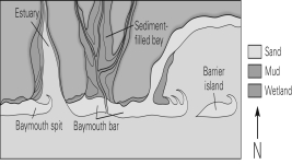
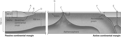
Using the figure below,which of the following lists correctly identifies the various seafloor landforms?
A)A = continental shelf,B = abyssal plain,C = mid-ocean ridge,D = trench
B)A = abyssal plain,B = continental shelf,C = mid-ocean ridge,D = trench
C)A = continental slope,B = mid-ocean ridge,C = trench,D = volcanic arc
D)A = continental shelf,B = abyssal plain,C = trench,D = mid-ocean ridge
A)A = continental shelf,B = abyssal plain,C = mid-ocean ridge,D = trench
B)A = abyssal plain,B = continental shelf,C = mid-ocean ridge,D = trench
C)A = continental slope,B = mid-ocean ridge,C = trench,D = volcanic arc
D)A = continental shelf,B = abyssal plain,C = trench,D = mid-ocean ridge
Question
Question
Question
Question
Question
Question
Question
Question
Question
Question
Question
Question
Question
Question
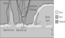
In the figure below,which direction is the longshore drift?
A)south
B)east
C)west
D)It is not possible to tell.
A)south
B)east
C)west
D)It is not possible to tell.
Question
Question
Question
Question
In the figure below,which letters represent the crest and trough?
A)A and B
B)E and D
C)C and D
D)C and B
A)A and B
B)E and D
C)C and D
D)C and B
Question
Which of the following figures shows a coast experiencing high tide?
A)A
B)B
C)C
D)D
A)A
B)B
C)C
D)D
Question
Question
Question
Question
Question
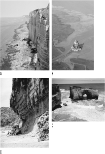
What will eventually happen to the headlands in the figure below?
A)They will join as the bays in between fill with sediment.
B)They will become a straight line of cliffs as rock is eroded away.
C)They will remain as they are for millions of years.
D)The sea will submerge them as the terrace is uplifted.
A)They will join as the bays in between fill with sediment.
B)They will become a straight line of cliffs as rock is eroded away.
C)They will remain as they are for millions of years.
D)The sea will submerge them as the terrace is uplifted.
Question
Question
Question
Question
Question
Question
Question
Question
Question
Question
Question
Question
Question
Question
Question
Question
Question
Question
Question
Question
Label the landforms of ocean basins shown in the image below using the following word bank (note: not all of the words will be used):


Unlock Deck
Sign up to unlock the cards in this deck!
Unlock Deck
Unlock Deck
1/55
Play
Full screen (f)
Deck 15: Restless Realm: Oceans and Coasts
1
You are running a sonar survey to map the bathymetry of an ocean basin.Using the following continuous sonar data giving the depth of the seafloor,what feature have you just discovered?
A)an abyssal plain
B)a deep trench
C)a mid-ocean ridge
D)a continental shelf
A)an abyssal plain
B)a deep trench
C)a mid-ocean ridge
D)a continental shelf
a mid-ocean ridge
2
Compared with the continental crust,the oceanic crust is ________.
A)denser
B)less dense
C)about the same density
D)about half as dense
A)denser
B)less dense
C)about the same density
D)about half as dense
A
3
Compared with the continental lithosphere,the oceanic lithosphere is ________.
A)thicker
B)thinner
C)approximately the same thickness
D)exactly five times thinner
A)thicker
B)thinner
C)approximately the same thickness
D)exactly five times thinner
B
4
Where do the deep ocean currents rise to the surface?
A)the equator
B)the North Pole
C)the tropics
D)the South Pole
A)the equator
B)the North Pole
C)the tropics
D)the South Pole
Unlock Deck
Unlock for access to all 55 flashcards in this deck.
Unlock Deck
k this deck
5
________ provides the largest tide-generating force.
A)The Sun
B)The Moon
C)Earth
D)The ocean
A)The Sun
B)The Moon
C)Earth
D)The ocean
Unlock Deck
Unlock for access to all 55 flashcards in this deck.
Unlock Deck
k this deck
6
Mid-ocean ridges (MORs),which are the sites of new oceanic crust formation,are linear mountain chains that run along divergent plate boundaries.Why does a MOR sit up higher than the surrounding oceanic crust?
A)Hot materials are less dense and shrink;thus,the new crust will sit higher than the surrounding crust.
B)As the hot magma exits the MOR,it shoots up higher than the surrounding crust.
C)Hot materials are less dense and expand;thus,the new crust will sit higher than the surrounding crust.
D)Hot,geothermal waters cause the new crust to expand and sit higher than the surrounding crust.
Unlock Deck
Unlock for access to all 55 flashcards in this deck.
Unlock Deck
k this deck
7
According to this map,where are you most likely to find upwelling currents?
A)the North Pole
B)the equator
C)the tropics
D)the South Pole
A)the North Pole
B)the equator
C)the tropics
D)the South Pole
Unlock Deck
Unlock for access to all 55 flashcards in this deck.
Unlock Deck
k this deck
8
The density of seawater increases with ________ temperature and ________ salinity.
A)increasing;increasing
B)decreasing;increasing
C)increasing;decreasing
D)decreasing;decreasing
A)increasing;increasing
B)decreasing;increasing
C)increasing;decreasing
D)decreasing;decreasing
Unlock Deck
Unlock for access to all 55 flashcards in this deck.
Unlock Deck
k this deck
9
Which of the following would be an area of the ocean with the LEAST dense water?
A)the mouth of the Amazon River
B)off the coast of Africa
C)the middle of the Pacific Ocean
D)off the coast of Madagascar
A)the mouth of the Amazon River
B)off the coast of Africa
C)the middle of the Pacific Ocean
D)off the coast of Madagascar
Unlock Deck
Unlock for access to all 55 flashcards in this deck.
Unlock Deck
k this deck
10
The sea surface salinity is ________ at the mouth of the Amazon River and ________ in the Great Salt Lake,Utah.
A)low;low
B)high;low
C)low;high
D)high;high
A)low;low
B)high;low
C)low;high
D)high;high
Unlock Deck
Unlock for access to all 55 flashcards in this deck.
Unlock Deck
k this deck
11
Using the figure below,which of the following lists correctly identifies the various seafloor landforms?
A)A = continental shelf,B = abyssal plain,C = mid-ocean ridge,D = trench
B)A = abyssal plain,B = continental shelf,C = mid-ocean ridge,D = trench
C)A = continental slope,B = mid-ocean ridge,C = trench,D = volcanic arc
D)A = continental shelf,B = abyssal plain,C = trench,D = mid-ocean ridge
A)A = continental shelf,B = abyssal plain,C = mid-ocean ridge,D = trench
B)A = abyssal plain,B = continental shelf,C = mid-ocean ridge,D = trench
C)A = continental slope,B = mid-ocean ridge,C = trench,D = volcanic arc
D)A = continental shelf,B = abyssal plain,C = trench,D = mid-ocean ridge
Unlock Deck
Unlock for access to all 55 flashcards in this deck.
Unlock Deck
k this deck
12
The shallowest portions of an ocean found along the margins of continents are the ________.
A)abyssal plains
B)continental rises
C)continental shelves
D)continental slopes
A)abyssal plains
B)continental rises
C)continental shelves
D)continental slopes
Unlock Deck
Unlock for access to all 55 flashcards in this deck.
Unlock Deck
k this deck
13
The deepest segments of the ocean floor are found ________.
A)along mid-ocean ridges
B)in the geographic centers of abyssal plains
C)in trenches associated with passive margins
D)in trenches associated with subduction zones
A)along mid-ocean ridges
B)in the geographic centers of abyssal plains
C)in trenches associated with passive margins
D)in trenches associated with subduction zones
Unlock Deck
Unlock for access to all 55 flashcards in this deck.
Unlock Deck
k this deck
14
What type of material would you expect to find on the continental slope?
A)basalt and plankton shells
B)carbonate-rich sediments and shells
C)silicic-rich gravels and plant remains
D)metamorphosed oceanic crust
A)basalt and plankton shells
B)carbonate-rich sediments and shells
C)silicic-rich gravels and plant remains
D)metamorphosed oceanic crust
Unlock Deck
Unlock for access to all 55 flashcards in this deck.
Unlock Deck
k this deck
15
Thermohaline circulation carries ________ water from the poles to the equator,where the water becomes ________.
A)warm;cold
B)cold;warm
C)low density;more dense
D)low density;more salty
A)warm;cold
B)cold;warm
C)low density;more dense
D)low density;more salty
Unlock Deck
Unlock for access to all 55 flashcards in this deck.
Unlock Deck
k this deck
16
Which is the larger of the two tidal bulges?
A)the one farthest from the Sun
B)the one farthest from the Moon
C)the one closest to the Sun
D)the one closest to the Moon
A)the one farthest from the Sun
B)the one farthest from the Moon
C)the one closest to the Sun
D)the one closest to the Moon
Unlock Deck
Unlock for access to all 55 flashcards in this deck.
Unlock Deck
k this deck
17
The Coriolis effect causes the apparent deflection of currents due to ________.
A)changes in wind speed
B)the rotation of Earth
C)changes in ocean currents
D)the location of the Moon
A)changes in wind speed
B)the rotation of Earth
C)changes in ocean currents
D)the location of the Moon
Unlock Deck
Unlock for access to all 55 flashcards in this deck.
Unlock Deck
k this deck
18
How would the Coriolis effect affect the space station?
A)The space station would curve to the right because it is above the Northern Hemisphere.
B)The space station would curve to the left because it is above the Southern Hemisphere.
C)The space station would not curve because it is above the equator and not affected.
D)The space station would not be affected because it is not in Earth's atmosphere.
Unlock Deck
Unlock for access to all 55 flashcards in this deck.
Unlock Deck
k this deck
19
The form and topography (depth profile)of the ocean floor is termed ________.
A)orogeny
B)bathymetry
C)allocthony
D)aquitopography
A)orogeny
B)bathymetry
C)allocthony
D)aquitopography
Unlock Deck
Unlock for access to all 55 flashcards in this deck.
Unlock Deck
k this deck
20
Major oceanic surface currents travel ________.
A)parallel to the prevailing wind direction in a region
B)in direct opposition to prevailing winds as a result of the Coriolis effect
C)at an angle to prevailing winds as a result of the Coriolis effect
D)at an angle to prevailing winds as a result of the Doppler effect
A)parallel to the prevailing wind direction in a region
B)in direct opposition to prevailing winds as a result of the Coriolis effect
C)at an angle to prevailing winds as a result of the Coriolis effect
D)at an angle to prevailing winds as a result of the Doppler effect
Unlock Deck
Unlock for access to all 55 flashcards in this deck.
Unlock Deck
k this deck
21
________ are gently sloping areas on coastlines that consist mostly of sand.
A)Tidal flats
B)Beaches
C)Lagoons
D)Inlets
A)Tidal flats
B)Beaches
C)Lagoons
D)Inlets
Unlock Deck
Unlock for access to all 55 flashcards in this deck.
Unlock Deck
k this deck
22
Longshore current is the result of waves ________.
A)coming in perpendicular to the shore
B)coming into shore at an angle
C)created during large storms
D)retreating back to the ocean
A)coming in perpendicular to the shore
B)coming into shore at an angle
C)created during large storms
D)retreating back to the ocean
Unlock Deck
Unlock for access to all 55 flashcards in this deck.
Unlock Deck
k this deck
23
Barrier islands are constantly moving in the direction of ________.
A)the longshore drift
B)the high tide
C)down welling
D)the Coriolis effect
A)the longshore drift
B)the high tide
C)down welling
D)the Coriolis effect
Unlock Deck
Unlock for access to all 55 flashcards in this deck.
Unlock Deck
k this deck
24
A wave will disturb the water to a depth equal to ________.
A)its wavelength
B)its surface amplitude
C)the bottom of the seafloor
D)one-half of its wavelength
A)its wavelength
B)its surface amplitude
C)the bottom of the seafloor
D)one-half of its wavelength
Unlock Deck
Unlock for access to all 55 flashcards in this deck.
Unlock Deck
k this deck
25
In the figure below,which direction is the longshore drift?
A)south
B)east
C)west
D)It is not possible to tell.
A)south
B)east
C)west
D)It is not possible to tell.
Unlock Deck
Unlock for access to all 55 flashcards in this deck.
Unlock Deck
k this deck
26
What prevents each spot on Earth from experiencing two high tides and two low tides a day?
A)the shape of the seafloor and coastline
B)the shape of the tidal bulges
C)the position of the Moon relative to Earth
D)the position of the Sun relative to the Moon
A)the shape of the seafloor and coastline
B)the shape of the tidal bulges
C)the position of the Moon relative to Earth
D)the position of the Sun relative to the Moon
Unlock Deck
Unlock for access to all 55 flashcards in this deck.
Unlock Deck
k this deck
27
High tide will be ________ when the Sun and Moon are aligned parallel to each other as opposed to normally (when they are not aligned parallel to each other).
A)the same
B)lower
C)higher
D)reversed
A)the same
B)lower
C)higher
D)reversed
Unlock Deck
Unlock for access to all 55 flashcards in this deck.
Unlock Deck
k this deck
28
Why are waves larger during storms?
A)The larger wind speeds create more shear.
B)The storm increases the amount of upwelling.
C)There is more water pulled in by the storm.
D)The motion of the water becomes more elliptical.
A)The larger wind speeds create more shear.
B)The storm increases the amount of upwelling.
C)There is more water pulled in by the storm.
D)The motion of the water becomes more elliptical.
Unlock Deck
Unlock for access to all 55 flashcards in this deck.
Unlock Deck
k this deck
29
In the figure below,which letters represent the crest and trough?
A)A and B
B)E and D
C)C and D
D)C and B
A)A and B
B)E and D
C)C and D
D)C and B
Unlock Deck
Unlock for access to all 55 flashcards in this deck.
Unlock Deck
k this deck
30
Which of the following figures shows a coast experiencing high tide?
A)A
B)B
C)C
D)D
A)A
B)B
C)C
D)D
Unlock Deck
Unlock for access to all 55 flashcards in this deck.
Unlock Deck
k this deck
31
Longshore currents ________ the shoreline.
A)flow directly toward
B)flow directly away from
C)flow parallel to
D)are not affected by
A)flow directly toward
B)flow directly away from
C)flow parallel to
D)are not affected by
Unlock Deck
Unlock for access to all 55 flashcards in this deck.
Unlock Deck
k this deck
32
When sea level rises and floods a glacially carved valley,the area is called a(n)________.
A)fjord
B)wetland
C)estuary
D)reef
A)fjord
B)wetland
C)estuary
D)reef
Unlock Deck
Unlock for access to all 55 flashcards in this deck.
Unlock Deck
k this deck
33
As a wave passes through the open ocean,the water molecules move ________.
A)horizontally
B)diagonally
C)in a circular path
D)straight up and down
A)horizontally
B)diagonally
C)in a circular path
D)straight up and down
Unlock Deck
Unlock for access to all 55 flashcards in this deck.
Unlock Deck
k this deck
34
What would happen to the tides if the Sun and Moon are aligned?
A)There would be no tides at all.
B)There would be no low tides on Earth.
C)High tide would be much larger.
D)There would be only low tides on Earth.
A)There would be no tides at all.
B)There would be no low tides on Earth.
C)High tide would be much larger.
D)There would be only low tides on Earth.
Unlock Deck
Unlock for access to all 55 flashcards in this deck.
Unlock Deck
k this deck
35
What will eventually happen to the headlands in the figure below?
A)They will join as the bays in between fill with sediment.
B)They will become a straight line of cliffs as rock is eroded away.
C)They will remain as they are for millions of years.
D)The sea will submerge them as the terrace is uplifted.
A)They will join as the bays in between fill with sediment.
B)They will become a straight line of cliffs as rock is eroded away.
C)They will remain as they are for millions of years.
D)The sea will submerge them as the terrace is uplifted.
Unlock Deck
Unlock for access to all 55 flashcards in this deck.
Unlock Deck
k this deck
36
If a beach is in an east-west orientation and the waves are approaching the shore from a southeasterly direction,in which direction will the longshore drift be?
A)northern
B)western
C)southern
D)eastern
A)northern
B)western
C)southern
D)eastern
Unlock Deck
Unlock for access to all 55 flashcards in this deck.
Unlock Deck
k this deck
37
Coastal landforms are constantly changing because the ________.
A)sand is constantly moving
B)tides are getting stronger
C)sand is moved by developers
D)storms are getting stronger
A)sand is constantly moving
B)tides are getting stronger
C)sand is moved by developers
D)storms are getting stronger
Unlock Deck
Unlock for access to all 55 flashcards in this deck.
Unlock Deck
k this deck
38
Waves are created by ________.
A)tides
B)the Moon
C)the crust
D)wind
A)tides
B)the Moon
C)the crust
D)wind
Unlock Deck
Unlock for access to all 55 flashcards in this deck.
Unlock Deck
k this deck
39
Because of wave refraction,erosion along an irregular coastline is ________.
A)even along the length of the coast
B)greatest along headlands
C)greatest in bays
D)the same as it would be along a regular coastline
A)even along the length of the coast
B)greatest along headlands
C)greatest in bays
D)the same as it would be along a regular coastline
Unlock Deck
Unlock for access to all 55 flashcards in this deck.
Unlock Deck
k this deck
40
The castle on the island of Mont Saint-Michel,France,can be accessed ________ a day during ________ tide.
A)twice;high
B)once;low
C)twice;low
D)once;high
A)twice;high
B)once;low
C)twice;low
D)once;high
Unlock Deck
Unlock for access to all 55 flashcards in this deck.
Unlock Deck
k this deck
41
If sea level continues to rise and covers the city of Miami,the Florida coast will become a(n) ________.
A)emergent coast
B)submergent coast
C)continental slope
D)abyssal plain
A)emergent coast
B)submergent coast
C)continental slope
D)abyssal plain
Unlock Deck
Unlock for access to all 55 flashcards in this deck.
Unlock Deck
k this deck
42
Explain why it is not a good idea to build on barrier islands.
Unlock Deck
Unlock for access to all 55 flashcards in this deck.
Unlock Deck
k this deck
43
Building a dam across a river can lead to ________ because sediment becomes trapped behind the dam.
A)pollution
B)beach nourishment
C)reef bleaching
D)beach erosion
A)pollution
B)beach nourishment
C)reef bleaching
D)beach erosion
Unlock Deck
Unlock for access to all 55 flashcards in this deck.
Unlock Deck
k this deck
44
Why do beaches become sediment-starved after dams are installed on rivers?
A)Dams trap water,thus reducing the volume of water that enters the ocean and erodes away the coast to produce sediment.
B)Rivers supply sediment to beaches;dams trap river sediment,and thus that sediment cannot make it to the beaches.
C)The chemical composition of river water is changed when it flows through a dam;this alters the amount of chemical weathering that occurs along the coast.
D)Dams are built using sediment covered in concrete;the sediment most often comes from nearby beaches.
Unlock Deck
Unlock for access to all 55 flashcards in this deck.
Unlock Deck
k this deck
45
Sea level is currently rising at 3.3 mm/yr,and scientists predict that global warming could cause a rise in sea level of 7 if left unabated.How long will it take the sea to rise 7 m at the current rate?
A)2,121 years
B)0.0004 year
C)2.121 years
D)0.47 year
A)2,121 years
B)0.0004 year
C)2.121 years
D)0.47 year
Unlock Deck
Unlock for access to all 55 flashcards in this deck.
Unlock Deck
k this deck
46
Many rocky coasts occur along active margins;why is this?
A)Active margins are associated with larger storms,which causes more erosion of sediment,leading to fewer beaches.
B)Active margins are associated with volcanic activity,and volcanic rocks are very hard to erode;thus,there is not enough sediment produced.
C)Active margins often experience repeated uplift,and thus the waves have not had sufficient time to erode the land surface down to sea level.
D)Active margins tend to have far fewer streams that feed sediment to the oceans;thus,there is not enough sand to create beaches.
Unlock Deck
Unlock for access to all 55 flashcards in this deck.
Unlock Deck
k this deck
47
When the sea level rises,an ocean may invade a river valley,producing a nearshore body of water of mixed and variable salinity termed a(n)________.
A)atoll
B)lagoon
C)estuary
D)jetty
A)atoll
B)lagoon
C)estuary
D)jetty
Unlock Deck
Unlock for access to all 55 flashcards in this deck.
Unlock Deck
k this deck
48
The entire state of Florida is composed of fossiliferous limestone.What does this imply about Florida during the recent past?
A)It was covered with caves.
B)It was a submergent coast.
C)It was an emergent coast.
D)It was in the mountains.
A)It was covered with caves.
B)It was a submergent coast.
C)It was an emergent coast.
D)It was in the mountains.
Unlock Deck
Unlock for access to all 55 flashcards in this deck.
Unlock Deck
k this deck
49
Describe what thermohaline circulation is and how it works.
Unlock Deck
Unlock for access to all 55 flashcards in this deck.
Unlock Deck
k this deck
50
Along beaches,groins have ________.
A)solved the problem of beach drift
B)increased erosion rates immediately up current from the groin
C)increased erosion rates immediately down current from the groin
D)increased depositional rates immediately down current from the groin
A)solved the problem of beach drift
B)increased erosion rates immediately up current from the groin
C)increased erosion rates immediately down current from the groin
D)increased depositional rates immediately down current from the groin
Unlock Deck
Unlock for access to all 55 flashcards in this deck.
Unlock Deck
k this deck
51
Describe what longshore drift is and how it works.
Unlock Deck
Unlock for access to all 55 flashcards in this deck.
Unlock Deck
k this deck
52
You have just bought your dream home along a coastline,but you notice that the beach in front of your new house is slowly disappearing.You decide to solve this by building a groin.Winds blow predominantly from east to west.Where do you place your groin?
A)parallel to the shoreline several meters offshore
B)perpendicular to the shore to the east of your house
C)perpendicular to the shore to the west of your house
D)perpendicular to the shore directly in front of your house
A)parallel to the shoreline several meters offshore
B)perpendicular to the shore to the east of your house
C)perpendicular to the shore to the west of your house
D)perpendicular to the shore directly in front of your house
Unlock Deck
Unlock for access to all 55 flashcards in this deck.
Unlock Deck
k this deck
53
Describe one way humans have tried to mitigate beach erosion.Was it ultimately successful in both the short term and long term?
Unlock Deck
Unlock for access to all 55 flashcards in this deck.
Unlock Deck
k this deck
54
Which type of coastline would most likely contain estuaries or fjords?
A)subductive
B)emergent
C)submergent
D)divergent
A)subductive
B)emergent
C)submergent
D)divergent
Unlock Deck
Unlock for access to all 55 flashcards in this deck.
Unlock Deck
k this deck
55
Label the landforms of ocean basins shown in the image below using the following word bank (note: not all of the words will be used):
Unlock Deck
Unlock for access to all 55 flashcards in this deck.
Unlock Deck
k this deck
Unlock Deck
Unlock for access to all 55 flashcards in this deck.


