Deck 1: Discovering the Earths Dimensions
Full screen (f)
Question
Question
Question
Question
Question
Question
Question
Question
Question
Question
Question
Question
Question
Question
Question
Question
Question
Question
Question
Question
Question
Question
Question
Question
Question
Question
Question
Question
Question
Question
Question
Question
Question
Question
Question
Question
Question
Question
Question
Question
Question
Question
Question
Question
The lines on the globe shown in part B of this figure are used to determine position east or west of the: 
A)prime meridian
B)north pole
C)equator
D)south pole
A)prime meridian
B)north pole
C)equator
D)south pole
Question
This illustration shows an example of a map using the __________ projection. 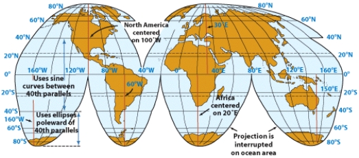
A)spherical
B)Goode
C)Winkel Tripel
D)Mercator
A)spherical
B)Goode
C)Winkel Tripel
D)Mercator
Question
Question
Question
If it was currently 4:00 pm in Miami, Florida, what time would it be in Corvallis on the coast of Oregon? 
A)5:00 pm
B)3:00 pm
C)7:00 pm
D)1:00 pm
A)5:00 pm
B)3:00 pm
C)7:00 pm
D)1:00 pm
Question
Question
Question
Part A of this figure demonstrates how the coordinate known as _______ is determined. 
A)prime meridian
B)equator
C)latitude
D)longitude
A)prime meridian
B)equator
C)latitude
D)longitude
Question
The lines on the globe shown in part A of this figure are used to determine position north or south of the: 
A)prime meridian
B)north pole
C)equator
D)south pole
A)prime meridian
B)north pole
C)equator
D)south pole
Question
Part B of this figure demonstrates how the coordinate known as _______ is determined. 
A)prime meridian
B)equator
C)latitude
D)longitude
A)prime meridian
B)equator
C)latitude
D)longitude
Question
This illustration shows an example of a map using the __________ projection. 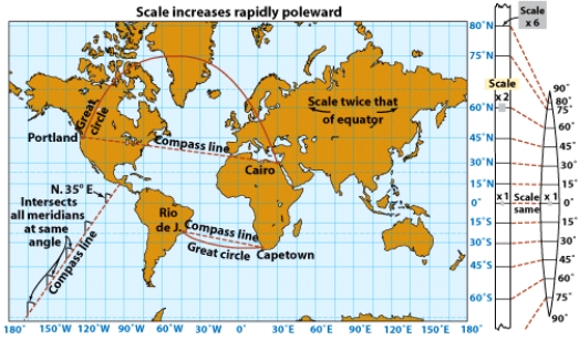
A)spherical
B)Goode
C)Winkel Tripel
D)Mercator
A)spherical
B)Goode
C)Winkel Tripel
D)Mercator
Question
The lines on the globe shown in part B of this figure are called: 
A)parallels
B)meridians
C)horizontals
D)verticals
A)parallels
B)meridians
C)horizontals
D)verticals
Question
The lines on the globe shown in part A of this figure are called: 
A)parallels
B)meridians
C)horizontals
D)verticals
A)parallels
B)meridians
C)horizontals
D)verticals
Question
Question
Question
Question
Question
If it was currently 4:00 pm in Los Angeles, California what time would it be in Miami, Florida? 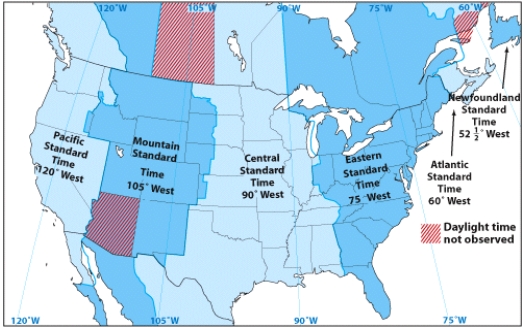
A)5:00 pm
B)3:00 pm
C)7:00 pm
D)1:00 pm
A)5:00 pm
B)3:00 pm
C)7:00 pm
D)1:00 pm
Question
Question
Question
Question
If it was currently 11:00 am in Oregon, what time would it be in Maine? 
A)2:00 pm
B)8:00 am
C)11:00 am
D)11:00 pm
A)2:00 pm
B)8:00 am
C)11:00 am
D)11:00 pm
Question
Question
Question
Question
Question
Question
Question
Question
Question
Question
Question
Question
Question
Question
Question

Unlock Deck
Sign up to unlock the cards in this deck!
Unlock Deck
Unlock Deck
1/104
Play
Full screen (f)
Deck 1: Discovering the Earths Dimensions
1
Lines connecting points of the same latitude are called:
A)meridians
B)perpendiculars
C)parallels
D)horizontals
A)meridians
B)perpendiculars
C)parallels
D)horizontals
C
2
Latitude values designate positions:
A)east and west of the equator
B)north and south of the equator
C)east and west of the prime meridian
D)north and south of the prime meridian
A)east and west of the equator
B)north and south of the equator
C)east and west of the prime meridian
D)north and south of the prime meridian
B
3
At the equator, the rotation of the earth is:
A)north to south
B)south to north
C)east to west
D)west to east
A)north to south
B)south to north
C)east to west
D)west to east
D
4
A hypothesis that has been tested and is strongly supported by experimentation, observation, and scientific evidence is known as a:
A)theory
B)observation
C)geographic inquiry
D)hypothesis
A)theory
B)observation
C)geographic inquiry
D)hypothesis
Unlock Deck
Unlock for access to all 104 flashcards in this deck.
Unlock Deck
k this deck
5
The parallel that lies midway between the poles is the:
A)prime meridian
B)Arctic circle
C)equator
D)Antarctic circle
A)prime meridian
B)Arctic circle
C)equator
D)Antarctic circle
Unlock Deck
Unlock for access to all 104 flashcards in this deck.
Unlock Deck
k this deck
6
A logical explanation for a process or phenomenon that allows prediction or testing by experiment is known as a(n):
A)explanation
B)scientific method
C)geographic explanation
D)hypothesis
A)explanation
B)scientific method
C)geographic explanation
D)hypothesis
Unlock Deck
Unlock for access to all 104 flashcards in this deck.
Unlock Deck
k this deck
7
Which of the following provide evidence of the earth's shape?
A)illumination patterns of clouds during sunset
B)disappearances of ships below the ocean horizon
C)photos from space
D)all of the above
A)illumination patterns of clouds during sunset
B)disappearances of ships below the ocean horizon
C)photos from space
D)all of the above
Unlock Deck
Unlock for access to all 104 flashcards in this deck.
Unlock Deck
k this deck
8
Which one of the following is NOT one of the five essential themes of Geography?
A)location
B)place
C)region
D)time
A)location
B)place
C)region
D)time
Unlock Deck
Unlock for access to all 104 flashcards in this deck.
Unlock Deck
k this deck
9
The poles are defined as the points on the earth's surface:
A)farthest from the plane of the ecliptic
B)closest to the plane of the ecliptic
C)where the magnetic field is generated
D)where the axis of rotation emerges
A)farthest from the plane of the ecliptic
B)closest to the plane of the ecliptic
C)where the magnetic field is generated
D)where the axis of rotation emerges
Unlock Deck
Unlock for access to all 104 flashcards in this deck.
Unlock Deck
k this deck
10
One degree of latitude or longitude can be subdivided into:
A)60 minutes
B)60 seconds
C)24 hours
D)12 months
A)60 minutes
B)60 seconds
C)24 hours
D)12 months
Unlock Deck
Unlock for access to all 104 flashcards in this deck.
Unlock Deck
k this deck
11
Which of the following includes the structural rock formation of the earth's surface?
A)atmosphere
B)lithosphere
C)biosphere
D)hydrosphere
A)atmosphere
B)lithosphere
C)biosphere
D)hydrosphere
Unlock Deck
Unlock for access to all 104 flashcards in this deck.
Unlock Deck
k this deck
12
The arc of a parallel between the prime meridian and a given point on the globe is:
A)a parallel
B)a meridian
C)latitude
D)longitude
A)a parallel
B)a meridian
C)latitude
D)longitude
Unlock Deck
Unlock for access to all 104 flashcards in this deck.
Unlock Deck
k this deck
13
The arc of a meridian between the equator and a given point on the globe is:
A)a parallel
B)a meridian
C)latitude
D)longitude
A)a parallel
B)a meridian
C)latitude
D)longitude
Unlock Deck
Unlock for access to all 104 flashcards in this deck.
Unlock Deck
k this deck
14
The geographic grid is composed of
A)verticals and horizontals
B)parallels and meridians
C)projections
D)none of the above
A)verticals and horizontals
B)parallels and meridians
C)projections
D)none of the above
Unlock Deck
Unlock for access to all 104 flashcards in this deck.
Unlock Deck
k this deck
15
The equatorial diameter of the earth is _________ than the polar diameter.
A)less than 1% smaller
B)more than 5% smaller
C)less than 1% larger
D)more than 5% larger
A)less than 1% smaller
B)more than 5% smaller
C)less than 1% larger
D)more than 5% larger
Unlock Deck
Unlock for access to all 104 flashcards in this deck.
Unlock Deck
k this deck
16
There are ____ degrees of latitude (north and south)and ____ degrees of longitude (east and west).
A)180; 360
B)90; 180
C)360; 180
D)180; 90
A)180; 360
B)90; 180
C)360; 180
D)180; 90
Unlock Deck
Unlock for access to all 104 flashcards in this deck.
Unlock Deck
k this deck
17
The imaginary straight line that passes through the center of the earth and the poles is known as the:
A)equator
B)prime meridian
C)plane of the ecliptic
D)axis
A)equator
B)prime meridian
C)plane of the ecliptic
D)axis
Unlock Deck
Unlock for access to all 104 flashcards in this deck.
Unlock Deck
k this deck
18
Lines connecting points of the same longitude are also called:
A)meridians
B)perpendiculars
C)parallels
D)horizontals
A)meridians
B)perpendiculars
C)parallels
D)horizontals
Unlock Deck
Unlock for access to all 104 flashcards in this deck.
Unlock Deck
k this deck
19
The shape of the earth most resembles a(n):
A)Perfect Sphere
B)Circle
C)Egg
D)Oblate spheroid
A)Perfect Sphere
B)Circle
C)Egg
D)Oblate spheroid
Unlock Deck
Unlock for access to all 104 flashcards in this deck.
Unlock Deck
k this deck
20
Longitude values designate positions:
A)east and west of the equator
B)north and south of the equator
C)east and west of the prime meridian
D)north and south of the prime meridian
A)east and west of the equator
B)north and south of the equator
C)east and west of the prime meridian
D)north and south of the prime meridian
Unlock Deck
Unlock for access to all 104 flashcards in this deck.
Unlock Deck
k this deck
21
If you walked directly east or west, you would:
A)be following a meridian
B)be following a parallel
C)be following an equinox
D)none of the above
A)be following a meridian
B)be following a parallel
C)be following an equinox
D)none of the above
Unlock Deck
Unlock for access to all 104 flashcards in this deck.
Unlock Deck
k this deck
22
An interrupted map projection that uses horizontal parallels and a combination of sine curves and ellipses to represent meridians is the:
A)Mercator projection
B)Goode projection
C)Winkel Tripel projection
D)none of the above
A)Mercator projection
B)Goode projection
C)Winkel Tripel projection
D)none of the above
Unlock Deck
Unlock for access to all 104 flashcards in this deck.
Unlock Deck
k this deck
23
Meridians run ______ around the globeand _______ the poles.
A)east-west; do not connect
B)north-south; do not connect
C)east-west; connect
D)north-south; connect
A)east-west; do not connect
B)north-south; do not connect
C)east-west; connect
D)north-south; connect
Unlock Deck
Unlock for access to all 104 flashcards in this deck.
Unlock Deck
k this deck
24
The network of parallels and meridians used to describe locations on the earth's surface is called the:
A)global projection
B)geoid
C)geographic grid
D)oblate spheroid
A)global projection
B)geoid
C)geographic grid
D)oblate spheroid
Unlock Deck
Unlock for access to all 104 flashcards in this deck.
Unlock Deck
k this deck
25
A map projection that accurately portrays the size of different areas on the earth's surface, but distorts the shape, is the:
A)Mercator projection
B)Goode projection
C)Winkel Tripel projection
D)none of the above
A)Mercator projection
B)Goode projection
C)Winkel Tripel projection
D)none of the above
Unlock Deck
Unlock for access to all 104 flashcards in this deck.
Unlock Deck
k this deck
26
A map projection is:
A)a system of meridians and parallels that represent the curved Earth on a flat surface
B)a method for enlarging a map
C)a method for reducing a map
D)a scale to allow representation of large areas on a small surface
A)a system of meridians and parallels that represent the curved Earth on a flat surface
B)a method for enlarging a map
C)a method for reducing a map
D)a scale to allow representation of large areas on a small surface
Unlock Deck
Unlock for access to all 104 flashcards in this deck.
Unlock Deck
k this deck
27
A map projection where a straight line will give a constant compass direction (though this direction doesn't represent the shortest distance between two points), is the:
A)Mercator projection
B)Goode projection
C)Winkel Tripel projection
D)none of the above
A)Mercator projection
B)Goode projection
C)Winkel Tripel projection
D)none of the above
Unlock Deck
Unlock for access to all 104 flashcards in this deck.
Unlock Deck
k this deck
28
A map projection that can portray the entire surface of the earth without any distortion is the:
A)Mercator projection
B)Goode projection
C)Winkel Tripel Projection
D)none of the above
A)Mercator projection
B)Goode projection
C)Winkel Tripel Projection
D)none of the above
Unlock Deck
Unlock for access to all 104 flashcards in this deck.
Unlock Deck
k this deck
29
Which of the following shapes cannot be made to lie flat?
A)plane
B)cone
C)cylinder
D)sphere
A)plane
B)cone
C)cylinder
D)sphere
Unlock Deck
Unlock for access to all 104 flashcards in this deck.
Unlock Deck
k this deck
30
Of the following, the map projection that would be most useful for comparing the sizes of regions is the:
A)Mercator projection
B)Goode projection
C)Winkel Tripel projection
D)none of the above
A)Mercator projection
B)Goode projection
C)Winkel Tripel projection
D)none of the above
Unlock Deck
Unlock for access to all 104 flashcards in this deck.
Unlock Deck
k this deck
31
If you walked directly north or south, you would:
A)be following a meridian
B)be following a parallel
C)be following an equinox
D)none of the above
A)be following a meridian
B)be following a parallel
C)be following an equinox
D)none of the above
Unlock Deck
Unlock for access to all 104 flashcards in this deck.
Unlock Deck
k this deck
32
A map projection composed of horizontal parallels and vertical meridians is the:
A)Mercator projection
B)Goode projection
C)Winkel Tripel projection
D)none of the above
A)Mercator projection
B)Goode projection
C)Winkel Tripel projection
D)none of the above
Unlock Deck
Unlock for access to all 104 flashcards in this deck.
Unlock Deck
k this deck
33
The prime meridian passes through
A)Berlin, Germany
B)Washington, D.C.
C)Rome, Italy
D)Greenwich, England
A)Berlin, Germany
B)Washington, D.C.
C)Rome, Italy
D)Greenwich, England
Unlock Deck
Unlock for access to all 104 flashcards in this deck.
Unlock Deck
k this deck
34
A value of zero degrees longitude occurs at the:
A)north pole
B)south pole
C)equator
D)prime meridian
A)north pole
B)south pole
C)equator
D)prime meridian
Unlock Deck
Unlock for access to all 104 flashcards in this deck.
Unlock Deck
k this deck
35
The ratio that tells us how to convert distances on a map to distances on the real world is called the:
A)conic projection
B)orthographic projection
C)scale fraction.
D)orthographic fraction
A)conic projection
B)orthographic projection
C)scale fraction.
D)orthographic fraction
Unlock Deck
Unlock for access to all 104 flashcards in this deck.
Unlock Deck
k this deck
36
A value of zero degrees latitude occurs at the:
A)north pole
B)south pole
C)equator
D)prime meridian
A)north pole
B)south pole
C)equator
D)prime meridian
Unlock Deck
Unlock for access to all 104 flashcards in this deck.
Unlock Deck
k this deck
37
Parallels run ______ around the globe and _______ the poles.
A)east-west; do not connect
B)north-south; do not connect
C)east-west; connect
D)north-south; connect
A)east-west; do not connect
B)north-south; do not connect
C)east-west; connect
D)north-south; connect
Unlock Deck
Unlock for access to all 104 flashcards in this deck.
Unlock Deck
k this deck
38
Of the following, the map projection that would be most useful for determining the compass direction between two locations is the:
A)Mercator projection
B)Goode projection
C)Winkel Tripel projection
D)none of the above
A)Mercator projection
B)Goode projection
C)Winkel Tripel projection
D)none of the above
Unlock Deck
Unlock for access to all 104 flashcards in this deck.
Unlock Deck
k this deck
39
Of the following, the map projection that has parallels that are nearly straight, curving slightly toward the edges of the map, and meridians that are increasingly curved farther from the central meridian is known as the:
A)Mercator projection
B)Goode projection
C)Winkel Tripel projection
D)none of the above
A)Mercator projection
B)Goode projection
C)Winkel Tripel projection
D)none of the above
Unlock Deck
Unlock for access to all 104 flashcards in this deck.
Unlock Deck
k this deck
40
At any given location, solar noon occurs:
A)at 12 am
B)at 12 pm
C)when the sun is at its highest point in the sky
D)when the sun is directly above the equator
A)at 12 am
B)at 12 pm
C)when the sun is at its highest point in the sky
D)when the sun is directly above the equator
Unlock Deck
Unlock for access to all 104 flashcards in this deck.
Unlock Deck
k this deck
41
The world time zones are centered on meridians that are spaced ____ degrees apart.
A)3
B)5
C)12
D)15
A)3
B)5
C)12
D)15
Unlock Deck
Unlock for access to all 104 flashcards in this deck.
Unlock Deck
k this deck
42
If you take a plane flight from San Francisco, CA to Seoul, South Korea, as you cross the international dateline the time will:
A)advance by one day
B)move back by one day
C)advance by 12 hours
D)move back by 12 hours
A)advance by one day
B)move back by one day
C)advance by 12 hours
D)move back by 12 hours
Unlock Deck
Unlock for access to all 104 flashcards in this deck.
Unlock Deck
k this deck
43
The time difference between the prime meridian and the international dateline is:
A)24 hours
B)12 hours
C)1 hour
D)none of the above
A)24 hours
B)12 hours
C)1 hour
D)none of the above
Unlock Deck
Unlock for access to all 104 flashcards in this deck.
Unlock Deck
k this deck
44
The lines on the globe shown in part B of this figure are used to determine position east or west of the:
A)prime meridian
B)north pole
C)equator
D)south pole
A)prime meridian
B)north pole
C)equator
D)south pole
Unlock Deck
Unlock for access to all 104 flashcards in this deck.
Unlock Deck
k this deck
45
This illustration shows an example of a map using the __________ projection.
A)spherical
B)Goode
C)Winkel Tripel
D)Mercator
A)spherical
B)Goode
C)Winkel Tripel
D)Mercator
Unlock Deck
Unlock for access to all 104 flashcards in this deck.
Unlock Deck
k this deck
46
When the international date line is crossed time:
A)changes by one day
B)changes by one hour
C)changes by 12 hours
D)does not change
A)changes by one day
B)changes by one hour
C)changes by 12 hours
D)does not change
Unlock Deck
Unlock for access to all 104 flashcards in this deck.
Unlock Deck
k this deck
47
The world time zones are generally separated in time by:
A)one hour
B)one minute
C)one day
D)one week
A)one hour
B)one minute
C)one day
D)one week
Unlock Deck
Unlock for access to all 104 flashcards in this deck.
Unlock Deck
k this deck
48
If it was currently 4:00 pm in Miami, Florida, what time would it be in Corvallis on the coast of Oregon?
A)5:00 pm
B)3:00 pm
C)7:00 pm
D)1:00 pm
A)5:00 pm
B)3:00 pm
C)7:00 pm
D)1:00 pm
Unlock Deck
Unlock for access to all 104 flashcards in this deck.
Unlock Deck
k this deck
49
Daylight savings time was instituted to give us an extra hour of daylight:
A)in the morning when people wake up
B)in the evening when people are active
C)at noon when people take their lunch break
D)none of the above
A)in the morning when people wake up
B)in the evening when people are active
C)at noon when people take their lunch break
D)none of the above
Unlock Deck
Unlock for access to all 104 flashcards in this deck.
Unlock Deck
k this deck
50
If you traveled from the location 45ᵒN, 130ᵒW to the location 45ᵒS, 130ᵒW you would experience a time change of:
A)12 hours
B)24 hours
C)0 hours
D)none of the above
A)12 hours
B)24 hours
C)0 hours
D)none of the above
Unlock Deck
Unlock for access to all 104 flashcards in this deck.
Unlock Deck
k this deck
51
Part A of this figure demonstrates how the coordinate known as _______ is determined.
A)prime meridian
B)equator
C)latitude
D)longitude
A)prime meridian
B)equator
C)latitude
D)longitude
Unlock Deck
Unlock for access to all 104 flashcards in this deck.
Unlock Deck
k this deck
52
The lines on the globe shown in part A of this figure are used to determine position north or south of the:
A)prime meridian
B)north pole
C)equator
D)south pole
A)prime meridian
B)north pole
C)equator
D)south pole
Unlock Deck
Unlock for access to all 104 flashcards in this deck.
Unlock Deck
k this deck
53
Part B of this figure demonstrates how the coordinate known as _______ is determined.
A)prime meridian
B)equator
C)latitude
D)longitude
A)prime meridian
B)equator
C)latitude
D)longitude
Unlock Deck
Unlock for access to all 104 flashcards in this deck.
Unlock Deck
k this deck
54
This illustration shows an example of a map using the __________ projection.
A)spherical
B)Goode
C)Winkel Tripel
D)Mercator
A)spherical
B)Goode
C)Winkel Tripel
D)Mercator
Unlock Deck
Unlock for access to all 104 flashcards in this deck.
Unlock Deck
k this deck
55
The lines on the globe shown in part B of this figure are called:
A)parallels
B)meridians
C)horizontals
D)verticals
A)parallels
B)meridians
C)horizontals
D)verticals
Unlock Deck
Unlock for access to all 104 flashcards in this deck.
Unlock Deck
k this deck
56
The lines on the globe shown in part A of this figure are called:
A)parallels
B)meridians
C)horizontals
D)verticals
A)parallels
B)meridians
C)horizontals
D)verticals
Unlock Deck
Unlock for access to all 104 flashcards in this deck.
Unlock Deck
k this deck
57
World Standard Time was developed because of:
A)difficulties in travel and transportation
B)difficulties in scheduling work shifts
C)the need for daylight savings time
D)different latitudes were using different systems
A)difficulties in travel and transportation
B)difficulties in scheduling work shifts
C)the need for daylight savings time
D)different latitudes were using different systems
Unlock Deck
Unlock for access to all 104 flashcards in this deck.
Unlock Deck
k this deck
58
Solar noon occurs simultaneously:
A)at places with the same latitude
B)at places with the same longitude
C)everywhere on the globe
D)nowhere on the globe
A)at places with the same latitude
B)at places with the same longitude
C)everywhere on the globe
D)nowhere on the globe
Unlock Deck
Unlock for access to all 104 flashcards in this deck.
Unlock Deck
k this deck
59
The country that covers the largest number of time zones is:
A)Russia
B)China
C)United States
D)Canada
A)Russia
B)China
C)United States
D)Canada
Unlock Deck
Unlock for access to all 104 flashcards in this deck.
Unlock Deck
k this deck
60
The international date line is located at:
A)the prime meridian
B)the 180ᵒ meridian
C)the equator
D)Greenwich, England
A)the prime meridian
B)the 180ᵒ meridian
C)the equator
D)Greenwich, England
Unlock Deck
Unlock for access to all 104 flashcards in this deck.
Unlock Deck
k this deck
61
If it was currently 4:00 pm in Los Angeles, California what time would it be in Miami, Florida?
A)5:00 pm
B)3:00 pm
C)7:00 pm
D)1:00 pm
A)5:00 pm
B)3:00 pm
C)7:00 pm
D)1:00 pm
Unlock Deck
Unlock for access to all 104 flashcards in this deck.
Unlock Deck
k this deck
62
The disappearance of the lower portion of a ship as it sails over the horizon is evidence that the world is round.
Unlock Deck
Unlock for access to all 104 flashcards in this deck.
Unlock Deck
k this deck
63
Latitude is the arc of a parallel between the prime meridian and a given point on the globe.
Unlock Deck
Unlock for access to all 104 flashcards in this deck.
Unlock Deck
k this deck
64
Parallels are circles that run east-west around the earth in planes parallel to the equator.
Unlock Deck
Unlock for access to all 104 flashcards in this deck.
Unlock Deck
k this deck
65
If it was currently 11:00 am in Oregon, what time would it be in Maine?
A)2:00 pm
B)8:00 am
C)11:00 am
D)11:00 pm
A)2:00 pm
B)8:00 am
C)11:00 am
D)11:00 pm
Unlock Deck
Unlock for access to all 104 flashcards in this deck.
Unlock Deck
k this deck
66
A map projection is an enlarged picture of the spherical world projected on a screen.
Unlock Deck
Unlock for access to all 104 flashcards in this deck.
Unlock Deck
k this deck
67
The earth's rotation is responsible for the division of time into days and nights.
Unlock Deck
Unlock for access to all 104 flashcards in this deck.
Unlock Deck
k this deck
68
The illumination of the clouds by the sun after it has sunk below the horizon is evidence that the world is round.
Unlock Deck
Unlock for access to all 104 flashcards in this deck.
Unlock Deck
k this deck
69
The Goode projection is composed of horizontal parallels and vertical meridians.
Unlock Deck
Unlock for access to all 104 flashcards in this deck.
Unlock Deck
k this deck
70
The North and South Poles are defined as the points on the earth's surface where the axis of rotation emerges.
Unlock Deck
Unlock for access to all 104 flashcards in this deck.
Unlock Deck
k this deck
71
Longitude is used to identify positions north and south of the prime meridian
Unlock Deck
Unlock for access to all 104 flashcards in this deck.
Unlock Deck
k this deck
72
Longitude is the arc of a meridian between the equator and a given point on the globe.
Unlock Deck
Unlock for access to all 104 flashcards in this deck.
Unlock Deck
k this deck
73
The Earth is perfectly spherical.
Unlock Deck
Unlock for access to all 104 flashcards in this deck.
Unlock Deck
k this deck
74
A map projection is a system of parallels and meridians representing the earth's curved surface drawn on a three-dimensional, spherical surface.
Unlock Deck
Unlock for access to all 104 flashcards in this deck.
Unlock Deck
k this deck
75
The Earth's polar diameter is larger than its equatorial diameter.
Unlock Deck
Unlock for access to all 104 flashcards in this deck.
Unlock Deck
k this deck
76
Latitude is used to identify positions north and south of the equator.
Unlock Deck
Unlock for access to all 104 flashcards in this deck.
Unlock Deck
k this deck
77
A map projection is a tool used to represent a three-dimensional sphere on a flat, two-dimensional surface.
Unlock Deck
Unlock for access to all 104 flashcards in this deck.
Unlock Deck
k this deck
78
Meridians are lines that run north-south around the earth and connect the poles.
Unlock Deck
Unlock for access to all 104 flashcards in this deck.
Unlock Deck
k this deck
79
The Earth's shape is closer to an oblate ellipsoid than a sphere.
Unlock Deck
Unlock for access to all 104 flashcards in this deck.
Unlock Deck
k this deck
80
The Earth's axis is an imaginary line running straight through its center and poles.
Unlock Deck
Unlock for access to all 104 flashcards in this deck.
Unlock Deck
k this deck
Unlock Deck
Unlock for access to all 104 flashcards in this deck.


