Deck 11: Floods
Full screen (f)
Question
Question
Question
Question
Question
Question
Question
Question
Question
Question
Question
Question
Question
Question
Question
Question
Question
Question
Question
Figure 11.3 shows the number of floods identified as natural disasters in Canada has been increasing.Which of the following statements regarding this trend is false? 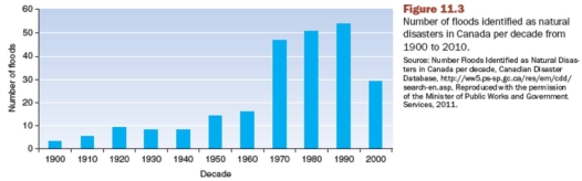
A) Better reporting in the second half of the century could result in the number of events being overrepresented
B) Increased development on flood-prone lands results in more flood damage
C) Sea-level rise has forced river flow to slow resulting in flooding
D) Possibly a result of long-term climatic change
Question
Question
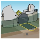
The machine in this figure (Figure 11.24)is used to: 
A) dig an irrigation canal.
B) clean an area covered by rock debris.
C) clean an area after snow avalanche.
D) collect small ice blocks into a large container.
E) break ice blocks.
A) dig an irrigation canal.
B) clean an area covered by rock debris.
C) clean an area after snow avalanche.
D) collect small ice blocks into a large container.
E) break ice blocks.
Question
Question
Question
Question
Question
Question
Question
Question
Question
Question
Question
Question
Question
Question
Question
Question
Question
Question
Arrow "A" in this figure (Figure 11.20)shows the following channel modification: 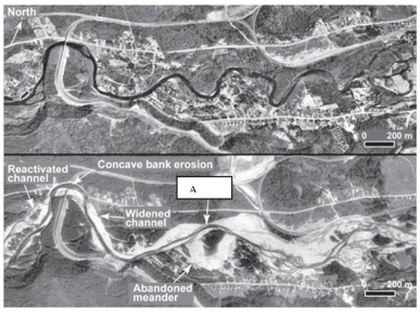
A) reactivated channel.
B) widened channel.
C) avulsion.
D) bank erosion.
E) convex bank erosion.
A) reactivated channel.
B) widened channel.
C) avulsion.
D) bank erosion.
E) convex bank erosion.
Question
Question
Question
Question
Question
Question
This figure (from Figure 11.38)shows a unique system which protects _______ from flooding. 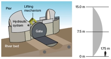
A) Winnipeg,Canada
B) London,England
C) New Orleans,U.S.A.
D) Paris,France
E) Belgrade,Serbia
A) Winnipeg,Canada
B) London,England
C) New Orleans,U.S.A.
D) Paris,France
E) Belgrade,Serbia
Question
Question
Question
Question
Question
Question
Question
Question
Question
Question
Question
Question
Question
Question
Question
Question
Question
Question
Question
Question
Question
Question
The radial gate in this figure (from Figure 11.38)is in closed position.

Unlock Deck
Sign up to unlock the cards in this deck!
Unlock Deck
Unlock Deck
1/67
Play
Full screen (f)
Deck 11: Floods
1
Natural levees are created during ______________.
A) floods
B) low flow conditions
C) normal flow conditions
D) beaver dam building
A) floods
B) low flow conditions
C) normal flow conditions
D) beaver dam building
A
2
What is the term used to describe to describe the slope of a stream bottom?
A) Discharge
B) Flux
C) Gradient
D) Load
E) Sinuosity
A) Discharge
B) Flux
C) Gradient
D) Load
E) Sinuosity
C
3
The original Red River Floodway was built between 1962 and 1968 _______________.
A) as a precautionary measure in an area that had not yet experienced a major flood
B) following a series of major floods in 1956,1958 and 1960
C) in response to the Red River flood of 1950
D) when a large dike protecting Winnipeg failed prematurely
A) as a precautionary measure in an area that had not yet experienced a major flood
B) following a series of major floods in 1956,1958 and 1960
C) in response to the Red River flood of 1950
D) when a large dike protecting Winnipeg failed prematurely
C
4
If a flood has a return period of ten years,it means ______________________.
A) that a similar-sized flood will occur once every ten years
B) that a similar-sized flood has a greater probability of occurring every tenth year than during any one of the intervening years
C) that in any given year a similar flood has a 10% chance of occurring
D) that the flood must be bigger than any other flood during any given 10-year interval
Unlock Deck
Unlock for access to all 67 flashcards in this deck.
Unlock Deck
k this deck
5
Which of the following statements regarding flood plains is false?
A) Streams build their flood plains by erosion and deposition.
B) Flood plains are the floors of streams during floods.
C) Flood plains are formed by waterfalls.
D) Streams reoccupy their flood plains during high discharge events.
A) Streams build their flood plains by erosion and deposition.
B) Flood plains are the floors of streams during floods.
C) Flood plains are formed by waterfalls.
D) Streams reoccupy their flood plains during high discharge events.
Unlock Deck
Unlock for access to all 67 flashcards in this deck.
Unlock Deck
k this deck
6
Why are floods so common along the Red River?
A) The Red River valley is geologically young (about 9,000 years old)and has not carved a deep valley.
B) The gradient or slope of the riverbed is very low.
C) River flow increases as winter snowmelts and melt water runs northward into still frozen parts of the river.
D) All of these are correct.
A) The Red River valley is geologically young (about 9,000 years old)and has not carved a deep valley.
B) The gradient or slope of the riverbed is very low.
C) River flow increases as winter snowmelts and melt water runs northward into still frozen parts of the river.
D) All of these are correct.
Unlock Deck
Unlock for access to all 67 flashcards in this deck.
Unlock Deck
k this deck
7
Statistically,the 100-year flood has a _____ chance of occurring any year.
A) 1%
B) 5%
C) 10%
D) 25%
E) 50%
A) 1%
B) 5%
C) 10%
D) 25%
E) 50%
Unlock Deck
Unlock for access to all 67 flashcards in this deck.
Unlock Deck
k this deck
8
Some factors that interact to make streams seek equilibrium are independent variables and others are dependent variables.Which of the following is(are)an independent variable(s)?
A) The volume of water flowing in the stream
B) The amount of sediment waiting to be moved
C) The sinuosity of the stream path
D) All of these are correct
E) Only the volume of water flowing in the stream and the amount of sediment waiting to be moved
A) The volume of water flowing in the stream
B) The amount of sediment waiting to be moved
C) The sinuosity of the stream path
D) All of these are correct
E) Only the volume of water flowing in the stream and the amount of sediment waiting to be moved
Unlock Deck
Unlock for access to all 67 flashcards in this deck.
Unlock Deck
k this deck
9
If a stream experiences too much discharge,the stream _____________________.
A) responds by increasing the sinuosity of its channel pattern through meandering
B) responds by decreasing the sinuosity of its channel pattern
C) will not change its sinuosity
D) will not change its flow path
A) responds by increasing the sinuosity of its channel pattern through meandering
B) responds by decreasing the sinuosity of its channel pattern
C) will not change its sinuosity
D) will not change its flow path
Unlock Deck
Unlock for access to all 67 flashcards in this deck.
Unlock Deck
k this deck
10
In Canada,which month has the highest number of natural disaster flooding events?
A) January
B) April
C) July
D) October
A) January
B) April
C) July
D) October
Unlock Deck
Unlock for access to all 67 flashcards in this deck.
Unlock Deck
k this deck
11
On a given stream,small floods happen _______________________.
A) with the same frequency as large floods
B) more often than large floods
C) less often than large floods,which explains why we hear about large floods more often in the news
D) sometimes more often,sometimes less often than large floods,depending on long-term climatic trends
A) with the same frequency as large floods
B) more often than large floods
C) less often than large floods,which explains why we hear about large floods more often in the news
D) sometimes more often,sometimes less often than large floods,depending on long-term climatic trends
Unlock Deck
Unlock for access to all 67 flashcards in this deck.
Unlock Deck
k this deck
12
The Red River Floodway expansion project was undertaken _______________.
A) as a precautionary measure against a 1-in-700 years flood
B) in response to the Red River flood of 1997
C) to protect a larger area around Winnipeg by extending the West Dike
D) all of these are correct
A) as a precautionary measure against a 1-in-700 years flood
B) in response to the Red River flood of 1997
C) to protect a larger area around Winnipeg by extending the West Dike
D) all of these are correct
Unlock Deck
Unlock for access to all 67 flashcards in this deck.
Unlock Deck
k this deck
13
Which of the following conditions promotes the infiltration of rainfall?
A) Intense precipitation
B) Saturated soil
C) Steep slopes
D) Thick vegetation cover
A) Intense precipitation
B) Saturated soil
C) Steep slopes
D) Thick vegetation cover
Unlock Deck
Unlock for access to all 67 flashcards in this deck.
Unlock Deck
k this deck
14
Runoff is ____________________.
A) the portion of water that flows over the land's surface into streams
B) is the average annual flow level for a stream
C) the level of stream flow following rainfall
D) is the minimum amount of flow possible for a stream
A) the portion of water that flows over the land's surface into streams
B) is the average annual flow level for a stream
C) the level of stream flow following rainfall
D) is the minimum amount of flow possible for a stream
Unlock Deck
Unlock for access to all 67 flashcards in this deck.
Unlock Deck
k this deck
15
A drainage basin ____________________.
A) is the point where water pools and the stream can no longer flow
B) is a body of water into which a river drains
C) acts like a funnel catching rainfall and draining water to a single outlet
D) is the widest area of a main stream
A) is the point where water pools and the stream can no longer flow
B) is a body of water into which a river drains
C) acts like a funnel catching rainfall and draining water to a single outlet
D) is the widest area of a main stream
Unlock Deck
Unlock for access to all 67 flashcards in this deck.
Unlock Deck
k this deck
16
If a stream is choked with sediment and has insufficient water to carry it away _________________.
A) the stream will respond by increasing the sinuosity of its channel pattern through meandering
B) the water will pick its way through as a braided stream
C) a canyon is formed
D) a flood will occur
A) the stream will respond by increasing the sinuosity of its channel pattern through meandering
B) the water will pick its way through as a braided stream
C) a canyon is formed
D) a flood will occur
Unlock Deck
Unlock for access to all 67 flashcards in this deck.
Unlock Deck
k this deck
17
What is the term used to describe the rate of water flow in a stream,expressed as volume per unit of time?
A) discharge
B) runoff C.gradient
C) load
D) sinuosity
A) discharge
B) runoff C.gradient
C) load
D) sinuosity
Unlock Deck
Unlock for access to all 67 flashcards in this deck.
Unlock Deck
k this deck
18
In Winnipeg the impact of the 2009 Red River flood was minimized because _________.
A) the floodway was able to divert most of the floodwater around the city
B) the dam at the lake at Morris south of Winnipeg held the water back
C) sand bag dikes built by volunteers diverted most of the floodwater away from the city
D) the levees added to the floodway provided the extra protection needed for floods of this magnitude
Unlock Deck
Unlock for access to all 67 flashcards in this deck.
Unlock Deck
k this deck
19
Figure 11.3 shows the number of floods identified as natural disasters in Canada has been increasing.Which of the following statements regarding this trend is false?
A) Better reporting in the second half of the century could result in the number of events being overrepresented
B) Increased development on flood-prone lands results in more flood damage
C) Sea-level rise has forced river flow to slow resulting in flooding
D) Possibly a result of long-term climatic change
Unlock Deck
Unlock for access to all 67 flashcards in this deck.
Unlock Deck
k this deck
20
Flood-frequency curves __________________.
A) map the extent of flood waters within the flood plain
B) are the meanders formed by erosion when discharge is high
C) are the meanders that can be counted to estimate the number of time a stream has flooded
D) plot historical data on flood discharge versus return period
A) map the extent of flood waters within the flood plain
B) are the meanders formed by erosion when discharge is high
C) are the meanders that can be counted to estimate the number of time a stream has flooded
D) plot historical data on flood discharge versus return period
Unlock Deck
Unlock for access to all 67 flashcards in this deck.
Unlock Deck
k this deck
21
The machine in this figure (Figure 11.24)is used to:
A) dig an irrigation canal.
B) clean an area covered by rock debris.
C) clean an area after snow avalanche.
D) collect small ice blocks into a large container.
E) break ice blocks.
A) dig an irrigation canal.
B) clean an area covered by rock debris.
C) clean an area after snow avalanche.
D) collect small ice blocks into a large container.
E) break ice blocks.
Unlock Deck
Unlock for access to all 67 flashcards in this deck.
Unlock Deck
k this deck
22
A large number of flash flood deaths __________________________.
A) are related to people swimming across flooded rivers
B) are related to people watching floods from bridges
C) are related to people trying to retrieve pets from flooded homes
D) are vehicle-related
E) are boat-related
A) are related to people swimming across flooded rivers
B) are related to people watching floods from bridges
C) are related to people trying to retrieve pets from flooded homes
D) are vehicle-related
E) are boat-related
Unlock Deck
Unlock for access to all 67 flashcards in this deck.
Unlock Deck
k this deck
23
"The Barrier" a lava flow that forms a natural dam in Garibaldi Provincial Park makes the areas below vulnerable to flooding.What is the mitigation strategy used here to reduce vulnerability?
A) Building a levee
B) Building a floodway
C) Channelization
D) Zoning and land-use policies
E) All of these are correct
A) Building a levee
B) Building a floodway
C) Channelization
D) Zoning and land-use policies
E) All of these are correct
Unlock Deck
Unlock for access to all 67 flashcards in this deck.
Unlock Deck
k this deck
24
If a "100-year flood" has occurred then ______________________.
A) a similar-sized flood will occur in 100 years time
B) that flood must be bigger than any other flood during the previous 100-year interval
C) in any given year a similar flood has a 0.001% chance of occurring
D) it is still possible for another flood of the same size to come again the following year
Unlock Deck
Unlock for access to all 67 flashcards in this deck.
Unlock Deck
k this deck
25
All of the following are correct about flood plains except:
A) they are built by erosion and deposition.
B) they offer a nurturing environment.
C) they have thick sediment cover and sheltered surroundings.
D) humans who decide to build on a flood plain are gamblers.
E) they are naturally protected from future flooding by a natural ridge of sediment,a natural levee.
Unlock Deck
Unlock for access to all 67 flashcards in this deck.
Unlock Deck
k this deck
26
What do you call the process by which flooding rivers abruptly change course,often to re-occupy abandoned channels?
A) Avulsion
B) Bank erosion
C) Channelization
D) Outburst
E) Redirection
A) Avulsion
B) Bank erosion
C) Channelization
D) Outburst
E) Redirection
Unlock Deck
Unlock for access to all 67 flashcards in this deck.
Unlock Deck
k this deck
27
A hydrograph is a plot of ___________________.
A) discharge versus time
B) water quality versus time
C) sediment load versus time
D) stream elevation versus distance downstream
A) discharge versus time
B) water quality versus time
C) sediment load versus time
D) stream elevation versus distance downstream
Unlock Deck
Unlock for access to all 67 flashcards in this deck.
Unlock Deck
k this deck
28
Dams give a sense of protection from floods,however major flooding occurs downstream due to ___________.
A) overtopping
B) heavy rains that fall below the dam
C) dam failure
D) all of these are correct
E) none of these are correct;dams are the most effective form of mitigation for flooding
A) overtopping
B) heavy rains that fall below the dam
C) dam failure
D) all of these are correct
E) none of these are correct;dams are the most effective form of mitigation for flooding
Unlock Deck
Unlock for access to all 67 flashcards in this deck.
Unlock Deck
k this deck
29
Floods are caused by ____________________.
A) the break-up of winter ice on rivers
B) abundant rainfall lasting for days
C) the storm surges of tropical cyclones flooding the coasts
D) local thunderstorms
E) all of these are correct
A) the break-up of winter ice on rivers
B) abundant rainfall lasting for days
C) the storm surges of tropical cyclones flooding the coasts
D) local thunderstorms
E) all of these are correct
Unlock Deck
Unlock for access to all 67 flashcards in this deck.
Unlock Deck
k this deck
30
In Canada,most floods are caused by ____________________.
A) spring snowmelt
B) abundant rainfall lasting for days
C) lahars failing
D) all of these are correct
E) spring snowmelt and abundant rainfall lasting for days
A) spring snowmelt
B) abundant rainfall lasting for days
C) lahars failing
D) all of these are correct
E) spring snowmelt and abundant rainfall lasting for days
Unlock Deck
Unlock for access to all 67 flashcards in this deck.
Unlock Deck
k this deck
31
Efforts to control rivers include all but which of the following?
A) Floodways
B) Levees
C) Channelization
D) Zoning and land-use policies
E) All of these are correct
A) Floodways
B) Levees
C) Channelization
D) Zoning and land-use policies
E) All of these are correct
Unlock Deck
Unlock for access to all 67 flashcards in this deck.
Unlock Deck
k this deck
32
Which of the following natural materials can obstruct water flow?
A) Debris from mass movements
B) Glacier ice
C) Lava flows
D) Moraines
E) All of these are correct
A) Debris from mass movements
B) Glacier ice
C) Lava flows
D) Moraines
E) All of these are correct
Unlock Deck
Unlock for access to all 67 flashcards in this deck.
Unlock Deck
k this deck
33
Hydrographs from urban settings _______________________.
A) look just like those from rural settings
B) show higher rates of runoff than rural settings,for a given precipitation event
C) show floods are of shorter duration than in rural settings,for a given precipitation event
D) show floods are of longer duration than in rural settings,for a given precipitation event
E) both show higher rates of runoff than rural settings,for a given precipitation event and show floods are of shorter duration than in rural settings,for a given precipitation event are correct.
Unlock Deck
Unlock for access to all 67 flashcards in this deck.
Unlock Deck
k this deck
34
Several flood-related deaths in Canada have been caused by ____________________.
A) flash floods when rapidly rising waters swept cars off the road
B) regional floods from abundant rainfall lasting for days
C) storm surges of tropical cyclones flooding the coasts
D) ice jam floods from the break-up of winter ice on rivers
E) collapse of man-made dams
A) flash floods when rapidly rising waters swept cars off the road
B) regional floods from abundant rainfall lasting for days
C) storm surges of tropical cyclones flooding the coasts
D) ice jam floods from the break-up of winter ice on rivers
E) collapse of man-made dams
Unlock Deck
Unlock for access to all 67 flashcards in this deck.
Unlock Deck
k this deck
35
Hydrographs often show that following peak discharge,stream level ____________.
A) returns rapidly to pre-flood base flow conditions
B) does not fall as rapidly as it rose due to groundwater moving into the stream
C) the flooding is the same because the amount of water is the same
A) returns rapidly to pre-flood base flow conditions
B) does not fall as rapidly as it rose due to groundwater moving into the stream
C) the flooding is the same because the amount of water is the same
Unlock Deck
Unlock for access to all 67 flashcards in this deck.
Unlock Deck
k this deck
36
The 2005 and 2013 Toronto storms brought rainfall in excess of the 1-in-100 year storm event.The potential reason for this might be:
A) too many hurricane events every year.
B) lowering water level in Lake Ontario.
C) increasing tornado events in the Toronto area.
D) intensification of severe storms due to climate change.
E) strong El Nino effect in these years.
A) too many hurricane events every year.
B) lowering water level in Lake Ontario.
C) increasing tornado events in the Toronto area.
D) intensification of severe storms due to climate change.
E) strong El Nino effect in these years.
Unlock Deck
Unlock for access to all 67 flashcards in this deck.
Unlock Deck
k this deck
37
Compounding factors involved in the 1996 Saguenay flood in Quebec include all but which of the following?
A) Complex network of water-control structures in various states of maintenance
B) Frozen soil
C) Torrential rains
D) Urbanization in areas vulnerable to flooding
A) Complex network of water-control structures in various states of maintenance
B) Frozen soil
C) Torrential rains
D) Urbanization in areas vulnerable to flooding
Unlock Deck
Unlock for access to all 67 flashcards in this deck.
Unlock Deck
k this deck
38
To mitigate future disasters after the 8th of July 2013 storm,the City of Toronto is encouraging ___________.
A) residents to leave the city areas which experienced urban flooding
B) residents to install flood-prevention devices (internal plumbing)
C) residents to build green roofs
D) residents to cover their backyards with impervious materials
E) residents to pay more insurance,so that insurance companies may cover complete flood damage
Unlock Deck
Unlock for access to all 67 flashcards in this deck.
Unlock Deck
k this deck
39
Arrow "A" in this figure (Figure 11.20)shows the following channel modification:
A) reactivated channel.
B) widened channel.
C) avulsion.
D) bank erosion.
E) convex bank erosion.
A) reactivated channel.
B) widened channel.
C) avulsion.
D) bank erosion.
E) convex bank erosion.
Unlock Deck
Unlock for access to all 67 flashcards in this deck.
Unlock Deck
k this deck
40
What do you call a flood due to the temporary obstruction of river flow by ice buildup?
A) Flash flood
B) Ice jam flood
C) Rainfall flood
D) Rain-on-snow flood
E) Snowmelt flood
A) Flash flood
B) Ice jam flood
C) Rainfall flood
D) Rain-on-snow flood
E) Snowmelt flood
Unlock Deck
Unlock for access to all 67 flashcards in this deck.
Unlock Deck
k this deck
41
Structural flood mitigation strategies,such as dams and levees,create a sense of security that results in increased vulnerability due to development and homes being built on the floodplain.
Unlock Deck
Unlock for access to all 67 flashcards in this deck.
Unlock Deck
k this deck
42
The number of floods in Canada has been decreasing steadily during the 20th century.
Unlock Deck
Unlock for access to all 67 flashcards in this deck.
Unlock Deck
k this deck
43
Floods in Canada cause few deaths but extensive damage.
Unlock Deck
Unlock for access to all 67 flashcards in this deck.
Unlock Deck
k this deck
44
The Red River Floodway is a detention reservoir where floodwaters are diverted and slowly released during times of low river flow levels.
Unlock Deck
Unlock for access to all 67 flashcards in this deck.
Unlock Deck
k this deck
45
This figure (from Figure 11.38)shows a unique system which protects _______ from flooding.
A) Winnipeg,Canada
B) London,England
C) New Orleans,U.S.A.
D) Paris,France
E) Belgrade,Serbia
A) Winnipeg,Canada
B) London,England
C) New Orleans,U.S.A.
D) Paris,France
E) Belgrade,Serbia
Unlock Deck
Unlock for access to all 67 flashcards in this deck.
Unlock Deck
k this deck
46
Even though a "150-year flood" may occur one year,it is still possible for another of the same size to come again in the following year,or even in the same year.
Unlock Deck
Unlock for access to all 67 flashcards in this deck.
Unlock Deck
k this deck
47
A channelization engineering project might include straightening,widening clearing debris from the channel to decrease the water carrying capability of the stream.
Unlock Deck
Unlock for access to all 67 flashcards in this deck.
Unlock Deck
k this deck
48
The probability that a 100-year flood will occur this year is 1%.
Unlock Deck
Unlock for access to all 67 flashcards in this deck.
Unlock Deck
k this deck
49
The largest evacuation in Canada due to a natural disaster involved 107,000 of Winnipeg's citizens when the Red River flooded (1950 flood).
Unlock Deck
Unlock for access to all 67 flashcards in this deck.
Unlock Deck
k this deck
50
Levee failure was a major cause of damage in New Orleans during Hurricane Katrina.
Unlock Deck
Unlock for access to all 67 flashcards in this deck.
Unlock Deck
k this deck
51
The catastrophic failure of natural dams triggers outburst floods.
Unlock Deck
Unlock for access to all 67 flashcards in this deck.
Unlock Deck
k this deck
52
Excesses in stream discharge or stream-sediment load are managed by the stream changing dependent variables,such as gradient and channel pattern.
Unlock Deck
Unlock for access to all 67 flashcards in this deck.
Unlock Deck
k this deck
53
A meandering stream lengthens its flow path,lowering the stream's gradient,and thus increasing the speed of its water flow.
Unlock Deck
Unlock for access to all 67 flashcards in this deck.
Unlock Deck
k this deck
54
The probability that a 100-year flood will occur at least once in 100 years is 1%.
Unlock Deck
Unlock for access to all 67 flashcards in this deck.
Unlock Deck
k this deck
55
Flood frequency can be accurately predicted with only a few years of stream discharge measurements.
Unlock Deck
Unlock for access to all 67 flashcards in this deck.
Unlock Deck
k this deck
56
"Natural dams" may be formed by all of the following except:
A) mass movement.
B) lava flows.
C) advance or retreat of glaciers.
D) combination of lava flows and glaciers.
E) building a dam.
A) mass movement.
B) lava flows.
C) advance or retreat of glaciers.
D) combination of lava flows and glaciers.
E) building a dam.
Unlock Deck
Unlock for access to all 67 flashcards in this deck.
Unlock Deck
k this deck
57
The probability that a 100-year flood will occur at least once in 100 years is 100%.
Unlock Deck
Unlock for access to all 67 flashcards in this deck.
Unlock Deck
k this deck
58
The major idea behind stream channelization is to:
A) follow the natural stream path.
B) make it easier for water to flow through the channel.
C) clear the channel of trees,debris and large boulders.
D) reduce channel roughness.
E) all of these,except,to follow the natural stream path.
A) follow the natural stream path.
B) make it easier for water to flow through the channel.
C) clear the channel of trees,debris and large boulders.
D) reduce channel roughness.
E) all of these,except,to follow the natural stream path.
Unlock Deck
Unlock for access to all 67 flashcards in this deck.
Unlock Deck
k this deck
59
In Canada,flash flooding most often occurs when a thick snowpack melts rapidly due to the late arrival of spring.
Unlock Deck
Unlock for access to all 67 flashcards in this deck.
Unlock Deck
k this deck
60
Statistically speaking,the larger the floods,the shorter the return period between them.
Unlock Deck
Unlock for access to all 67 flashcards in this deck.
Unlock Deck
k this deck
61
From the flood-frequency curves for small urban drainage basins (100% of area sewered)we can conclude that the flood recurrence interval is very low.
Unlock Deck
Unlock for access to all 67 flashcards in this deck.
Unlock Deck
k this deck
62
Rivers flowing from north to south (e.g.Red River and Mackenzie River)are particularly vulnerable to ice jam floods.
Unlock Deck
Unlock for access to all 67 flashcards in this deck.
Unlock Deck
k this deck
63
Since 2005,the latest radar satellite technology has been applied to monitor ice on Fraser River,British Columbia.
Unlock Deck
Unlock for access to all 67 flashcards in this deck.
Unlock Deck
k this deck
64
When a flood crest passes downstream,stream level falls more rapidly than it rose.
Unlock Deck
Unlock for access to all 67 flashcards in this deck.
Unlock Deck
k this deck
65
"The Barrier," located in Garibaldi Provincial park in British Columbia,was formed when massive rock debris filled the valley up to 300 m high (also called landslide dam).
Unlock Deck
Unlock for access to all 67 flashcards in this deck.
Unlock Deck
k this deck
66
Pictograms prepared by the City of Calgary after the 2013 Calgary flood show hydrograms and water levels at the confluence of the Bow and Elbow Rivers.
Unlock Deck
Unlock for access to all 67 flashcards in this deck.
Unlock Deck
k this deck
67
The radial gate in this figure (from Figure 11.38)is in closed position.
Unlock Deck
Unlock for access to all 67 flashcards in this deck.
Unlock Deck
k this deck
Unlock Deck
Unlock for access to all 67 flashcards in this deck.


