Deck 17: Dry Regions: the Geology of Deserts
Full screen (f)
Question
Question
The figure below illustrates the formation of a ________. 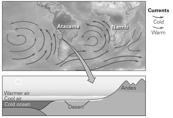
A) coastal desert
B) subtropical desert
C) rain-shadow desert
D) continental-interior desert
A) coastal desert
B) subtropical desert
C) rain-shadow desert
D) continental-interior desert
Question
Question
Question
Question
Question
The petroglyph in the image below is carved into _______,revealing the lighter-colored bedrock underneath. 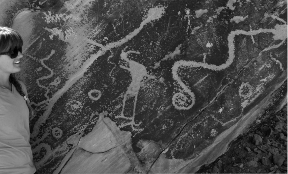
A) basalt
B) desert varnish
C) caliche
D) salt
A) basalt
B) desert varnish
C) caliche
D) salt
Question
Question
Question
Question
Question
Question
Question
Question
Question
Question
Question
Question
Question
Question
Question
Question
Question
Question
Which letter corresponds to talus in this image? 
A) A
B) B
C) C
D) D
A) A
B) B
C) C
D) D
Question
Question
Question
In the figure below,the sand grains are being transported by ________. 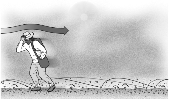
A) suspension
B) saltation
C) surface creep
D) deflation
A) suspension
B) saltation
C) surface creep
D) deflation
Question
Question
The figure below demonstrates the formation of a surface layer of coarse material on the surface in deserts called 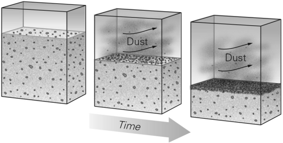
A) a blowout deposit.
B) a lag deposit.
C) an arroyo.
D) badlands.
A) a blowout deposit.
B) a lag deposit.
C) an arroyo.
D) badlands.
Question
Question
Question
Question
Question
Question
Question
Question
Question
Question
Question
Question
Question
Question
Question
Question
Question
Question
Question
Question
Question
Question
Question
Question
Question
Question
Question
Question
Question
Question

Unlock Deck
Sign up to unlock the cards in this deck!
Unlock Deck
Unlock Deck
1/60
Play
Full screen (f)
Deck 17: Dry Regions: the Geology of Deserts
1
The definition of a desert depends on a region's ________.
A) latitude
B) elevation
C) aridity
D) temperature
A) latitude
B) elevation
C) aridity
D) temperature
C
2
The figure below illustrates the formation of a ________.
A) coastal desert
B) subtropical desert
C) rain-shadow desert
D) continental-interior desert
A) coastal desert
B) subtropical desert
C) rain-shadow desert
D) continental-interior desert
A
3
Why is water a very effective agent of erosion in deserts?
A) The action of running water is not lessened by vegetation cover in deserts.
B) The hotter water temperature in deserts carries more energy.
C) Deserts have many more small streams than other landscapes.
D) Slopes are steeper in deserts,making running water more powerful.
A) The action of running water is not lessened by vegetation cover in deserts.
B) The hotter water temperature in deserts carries more energy.
C) Deserts have many more small streams than other landscapes.
D) Slopes are steeper in deserts,making running water more powerful.
A
4
The Atacama Desert in Chile is a desert primarily because it is located ________.
A) in the subtropics
B) near the South Pole
C) near the center of a large continent
D) next to a cold ocean current
A) in the subtropics
B) near the South Pole
C) near the center of a large continent
D) next to a cold ocean current
Unlock Deck
Unlock for access to all 60 flashcards in this deck.
Unlock Deck
k this deck
5
Deserts represent ________ of the Earth's land surface.
A) less than 5 percent
B) about 10 percent
C) about 25 percent
D) more than 50 percent
A) less than 5 percent
B) about 10 percent
C) about 25 percent
D) more than 50 percent
Unlock Deck
Unlock for access to all 60 flashcards in this deck.
Unlock Deck
k this deck
6
Isolated mountains that stick up above large expanses of desert alluvium are called
A) inselbergs
B) playas
C) mesas
D) desert pavement
A) inselbergs
B) playas
C) mesas
D) desert pavement
Unlock Deck
Unlock for access to all 60 flashcards in this deck.
Unlock Deck
k this deck
7
The petroglyph in the image below is carved into _______,revealing the lighter-colored bedrock underneath.
A) basalt
B) desert varnish
C) caliche
D) salt
A) basalt
B) desert varnish
C) caliche
D) salt
Unlock Deck
Unlock for access to all 60 flashcards in this deck.
Unlock Deck
k this deck
8
Many desert streams are ephemeral,meaning
A) they are supplied by groundwater and not by rainfall.
B) they only carry water after rainfall events,and most of the time they are dry streambeds.
C) they only occur on north-facing slopes.
D) they quickly evaporate when the sun is shining.
A) they are supplied by groundwater and not by rainfall.
B) they only carry water after rainfall events,and most of the time they are dry streambeds.
C) they only occur on north-facing slopes.
D) they quickly evaporate when the sun is shining.
Unlock Deck
Unlock for access to all 60 flashcards in this deck.
Unlock Deck
k this deck
9
The Great Basin deserts found in the western United States are primarily the result of being located ________.
A) in the subtropics
B) within the rain shadow of one or more mountain ranges
C) near the center of a large continent
D) next to a cold ocean current
A) in the subtropics
B) within the rain shadow of one or more mountain ranges
C) near the center of a large continent
D) next to a cold ocean current
Unlock Deck
Unlock for access to all 60 flashcards in this deck.
Unlock Deck
k this deck
10
What is the main feature of atmospheric circulation at 20° to 30° north and south latitude?
A) Cool,dry air sinks,becoming drier as it heats up.
B) Warm,moist air rises,increasing in relative humidity as it rises.
C) Warm,dry air rises,becoming cooler.
D) Cool moist air sinks,providing abundant rainfall.
A) Cool,dry air sinks,becoming drier as it heats up.
B) Warm,moist air rises,increasing in relative humidity as it rises.
C) Warm,dry air rises,becoming cooler.
D) Cool moist air sinks,providing abundant rainfall.
Unlock Deck
Unlock for access to all 60 flashcards in this deck.
Unlock Deck
k this deck
11
To qualify as a desert,a region must ________.
A) be hot,with a mean annual temperature greater than 25°C (77°F)
B) be arid,with less than 15 percent of the ground surface vegetated
C) have a mean annual temperature greater than 25°C and less than 5 cm annual rainfall
D) have no rainfall three out of four seasons
A) be hot,with a mean annual temperature greater than 25°C (77°F)
B) be arid,with less than 15 percent of the ground surface vegetated
C) have a mean annual temperature greater than 25°C and less than 5 cm annual rainfall
D) have no rainfall three out of four seasons
Unlock Deck
Unlock for access to all 60 flashcards in this deck.
Unlock Deck
k this deck
12
The highest recorded temperatures on the Earth occur in
A) mid-latitude,rain shadow deserts.
B) mid-latitude,continental interior deserts.
C) low-latitude,low-elevation rainforests.
D) low-latitude,low-elevation deserts.
A) mid-latitude,rain shadow deserts.
B) mid-latitude,continental interior deserts.
C) low-latitude,low-elevation rainforests.
D) low-latitude,low-elevation deserts.
Unlock Deck
Unlock for access to all 60 flashcards in this deck.
Unlock Deck
k this deck
13
Continental interior deserts occur because
A) there are no rivers in the interior of continents to provide water vapor.
B) air masses lose much of their moisture before reaching continent interiors.
C) continent interiors are located at low latitudes where air rises.
D) atmospheric circulation in the interior of continents is characterized by dry sinking air masses.
Unlock Deck
Unlock for access to all 60 flashcards in this deck.
Unlock Deck
k this deck
14
Caliche and calcrete are terms for
A) economically important cement mineral resources mined from desert regions.
B) unique desert soils where grains of regolith are cemented together.
C) dark mineral deposits that develop on rock exposures in deserts.
D) faceted rocks carved by wind erosions in desert landscapes.
A) economically important cement mineral resources mined from desert regions.
B) unique desert soils where grains of regolith are cemented together.
C) dark mineral deposits that develop on rock exposures in deserts.
D) faceted rocks carved by wind erosions in desert landscapes.
Unlock Deck
Unlock for access to all 60 flashcards in this deck.
Unlock Deck
k this deck
15
Coastal region deserts are most likely to occur along coastlines adjacent to ________ ocean currents.
A) warm
B) cold
C) upwelling
D) nutrient-rich
A) warm
B) cold
C) upwelling
D) nutrient-rich
Unlock Deck
Unlock for access to all 60 flashcards in this deck.
Unlock Deck
k this deck
16
The Gobi in Mongolia is a desert primarily because it is located ________.
A) in the subtropics
B) in a polar region
C) near the center of a large continent
D) next to a cold ocean current
A) in the subtropics
B) in a polar region
C) near the center of a large continent
D) next to a cold ocean current
Unlock Deck
Unlock for access to all 60 flashcards in this deck.
Unlock Deck
k this deck
17
The colors of the landscape in desert regions are controlled by ________.
A) what type of desert it is
B) the air temperature
C) the season of the year
D) the composition of the bedrock
A) what type of desert it is
B) the air temperature
C) the season of the year
D) the composition of the bedrock
Unlock Deck
Unlock for access to all 60 flashcards in this deck.
Unlock Deck
k this deck
18
Much of the land area north of the Arctic Circle is considered to be a desert because
A) summer temperatures can get very hot.
B) the Arctic Ocean provides cold water currents.
C) it is extremely arid.
D) there is no rain; only snowfall.
A) summer temperatures can get very hot.
B) the Arctic Ocean provides cold water currents.
C) it is extremely arid.
D) there is no rain; only snowfall.
Unlock Deck
Unlock for access to all 60 flashcards in this deck.
Unlock Deck
k this deck
19
Desert climates associated with a rain shadow are found ________.
A) on the windward side of mountain ranges
B) on the leeward side of mountain ranges
C) in the middle of flat plains
D) along continental coastlines
A) on the windward side of mountain ranges
B) on the leeward side of mountain ranges
C) in the middle of flat plains
D) along continental coastlines
Unlock Deck
Unlock for access to all 60 flashcards in this deck.
Unlock Deck
k this deck
20
A desert may form along a coastline because a ________.
A) warm current warms and dries the air
B) warm current forces hot air inland
C) cold current cools and dries the air
D) cold current forces hot air inland
A) warm current warms and dries the air
B) warm current forces hot air inland
C) cold current cools and dries the air
D) cold current forces hot air inland
Unlock Deck
Unlock for access to all 60 flashcards in this deck.
Unlock Deck
k this deck
21
Talus aprons represent accumulations of ________.
A) angular debris at the base of a hill
B) lag deposits
C) coarse sediment in a deflation basin
D) loess at the edge of a desert
A) angular debris at the base of a hill
B) lag deposits
C) coarse sediment in a deflation basin
D) loess at the edge of a desert
Unlock Deck
Unlock for access to all 60 flashcards in this deck.
Unlock Deck
k this deck
22
Playas are important resources for minerals such as
A) feldspar.
B) olivine.
C) borax.
D) quartz.
A) feldspar.
B) olivine.
C) borax.
D) quartz.
Unlock Deck
Unlock for access to all 60 flashcards in this deck.
Unlock Deck
k this deck
23
What is talus?
A) thick crusts of cemented soil
B) angular rocky debris at the base of a cliff
C) the formal term for sand dunes
D) rocks with faceted faces abraded by wind
A) thick crusts of cemented soil
B) angular rocky debris at the base of a cliff
C) the formal term for sand dunes
D) rocks with faceted faces abraded by wind
Unlock Deck
Unlock for access to all 60 flashcards in this deck.
Unlock Deck
k this deck
24
A(n)________ consists of sand and gravel deposited by ephemeral distributary channels that occur where a gully or a canyon discharges from its mouth.
A) alluvial fan
B) ventifact
C) wadi
D) yardang
A) alluvial fan
B) ventifact
C) wadi
D) yardang
Unlock Deck
Unlock for access to all 60 flashcards in this deck.
Unlock Deck
k this deck
25
Which letter corresponds to talus in this image?
A) A
B) B
C) C
D) D
A) A
B) B
C) C
D) D
Unlock Deck
Unlock for access to all 60 flashcards in this deck.
Unlock Deck
k this deck
26
Wind-carved elaborate mounds and ridges are termed ________.
A) mirages
B) caliches
C) sabkhas
D) yardangs
A) mirages
B) caliches
C) sabkhas
D) yardangs
Unlock Deck
Unlock for access to all 60 flashcards in this deck.
Unlock Deck
k this deck
27
What is a ventifact?
A) a bowl-like depression carved by wind
B) an exposed rock with facets carved by wind
C) a tool left by former civilizations that lived in deserts
D) coarse-grained sediments that are not carried in desert dust storms
A) a bowl-like depression carved by wind
B) an exposed rock with facets carved by wind
C) a tool left by former civilizations that lived in deserts
D) coarse-grained sediments that are not carried in desert dust storms
Unlock Deck
Unlock for access to all 60 flashcards in this deck.
Unlock Deck
k this deck
28
In the figure below,the sand grains are being transported by ________.
A) suspension
B) saltation
C) surface creep
D) deflation
A) suspension
B) saltation
C) surface creep
D) deflation
Unlock Deck
Unlock for access to all 60 flashcards in this deck.
Unlock Deck
k this deck
29
The slope of a pile of talus is typically _______ than the slope of an alluvial fan.
A) less irregular
B) less steep
C) steeper
D) more stable underfoot
A) less irregular
B) less steep
C) steeper
D) more stable underfoot
Unlock Deck
Unlock for access to all 60 flashcards in this deck.
Unlock Deck
k this deck
30
The figure below demonstrates the formation of a surface layer of coarse material on the surface in deserts called
A) a blowout deposit.
B) a lag deposit.
C) an arroyo.
D) badlands.
A) a blowout deposit.
B) a lag deposit.
C) an arroyo.
D) badlands.
Unlock Deck
Unlock for access to all 60 flashcards in this deck.
Unlock Deck
k this deck
31
Which of the following describes sediment deposition in alluvial fans?
A) It is where streams in valleys are dammed by large mountains.
B) It is where streams sink into the subsurface and drop their sediment load.
C) It is where dunes pile sediment against the base of a mountain.
D) It is where the slope of the stream decreases and the water slows.
A) It is where streams in valleys are dammed by large mountains.
B) It is where streams sink into the subsurface and drop their sediment load.
C) It is where dunes pile sediment against the base of a mountain.
D) It is where the slope of the stream decreases and the water slows.
Unlock Deck
Unlock for access to all 60 flashcards in this deck.
Unlock Deck
k this deck
32
Over time,alluvial fans may merge to form a ________.
A) wadi
B) talus apron
C) playa
D) bajada
A) wadi
B) talus apron
C) playa
D) bajada
Unlock Deck
Unlock for access to all 60 flashcards in this deck.
Unlock Deck
k this deck
33
A salt-rich flat lake bed in called a
A) wadi.
B) pediment.
C) playa.
D) bajada.
A) wadi.
B) pediment.
C) playa.
D) bajada.
Unlock Deck
Unlock for access to all 60 flashcards in this deck.
Unlock Deck
k this deck
34
Alluvial fans accumulate in deserts at the mouth of ________
A) canyons
B) sand dunes
C) playas
D) talus slopes
A) canyons
B) sand dunes
C) playas
D) talus slopes
Unlock Deck
Unlock for access to all 60 flashcards in this deck.
Unlock Deck
k this deck
35
The process of lowering the land surface by wind erosion is known as ________.
A) saltation
B) deflation
C) desertification
D) escarpment
A) saltation
B) deflation
C) desertification
D) escarpment
Unlock Deck
Unlock for access to all 60 flashcards in this deck.
Unlock Deck
k this deck
36
A mesa is most likely to form if the underlying bedrock is
A) folded sedimentary rock.
B) fault-tilted sedimentary rock.
C) flat-lying sedimentary rock.
D) igneous rock.
A) folded sedimentary rock.
B) fault-tilted sedimentary rock.
C) flat-lying sedimentary rock.
D) igneous rock.
Unlock Deck
Unlock for access to all 60 flashcards in this deck.
Unlock Deck
k this deck
37
Why are salt lakes salty?
A) because desert streams carry very salty water
B) because mineral springs deliver salt water to such lakes
C) because evaporation from the lakes removes water but not salt
D) because rainfall in deserts is salty
A) because desert streams carry very salty water
B) because mineral springs deliver salt water to such lakes
C) because evaporation from the lakes removes water but not salt
D) because rainfall in deserts is salty
Unlock Deck
Unlock for access to all 60 flashcards in this deck.
Unlock Deck
k this deck
38
Fine-grained sediments such as dust and silt can stay in the air and be transported by wind as ________.
A) suspended load
B) saltation
C) deflation clasts
D) desert varnish
A) suspended load
B) saltation
C) deflation clasts
D) desert varnish
Unlock Deck
Unlock for access to all 60 flashcards in this deck.
Unlock Deck
k this deck
39
Most of the erosion in desert environments is caused by ________.
A) wind
B) surface water
C) groundwater
D) salt wedging
A) wind
B) surface water
C) groundwater
D) salt wedging
Unlock Deck
Unlock for access to all 60 flashcards in this deck.
Unlock Deck
k this deck
40
Where would you go among the following to find a salt lake?
A) Florida
B) Utah
C) Michigan
D) Hawaii
A) Florida
B) Utah
C) Michigan
D) Hawaii
Unlock Deck
Unlock for access to all 60 flashcards in this deck.
Unlock Deck
k this deck
41
Explain the global-scale pattern of atmospheric circulation that leads to the formation of subtropical deserts.
Unlock Deck
Unlock for access to all 60 flashcards in this deck.
Unlock Deck
k this deck
42
Why are flash floods so effective at transporting sediment?
Unlock Deck
Unlock for access to all 60 flashcards in this deck.
Unlock Deck
k this deck
43
Areas with relatively scarce sand and constantly shifting winds will develop ________ dunes.
A) star
B) barchan
C) parabolic
D) longitudinal
A) star
B) barchan
C) parabolic
D) longitudinal
Unlock Deck
Unlock for access to all 60 flashcards in this deck.
Unlock Deck
k this deck
44
What is the dominant erosional force in deserts: wind or water? Why?
Unlock Deck
Unlock for access to all 60 flashcards in this deck.
Unlock Deck
k this deck
45
Plowing soil and overgrazing by livestock in arid regions can contribute to
A) loss of sand dunes.
B) growth of desert varnish.
C) accelerated soil erosion.
D) decreases in precipitation.
A) loss of sand dunes.
B) growth of desert varnish.
C) accelerated soil erosion.
D) decreases in precipitation.
Unlock Deck
Unlock for access to all 60 flashcards in this deck.
Unlock Deck
k this deck
46
Imagine you are a farmer moving into the Great Plains area after the Dust Bowl of the 1930s.What can you do to make the land fertile enough for farming again? What can be done to prevent a similar disaster from happening again?
Unlock Deck
Unlock for access to all 60 flashcards in this deck.
Unlock Deck
k this deck
47
How can overpopulation contribute to desertification of a landscape?
Unlock Deck
Unlock for access to all 60 flashcards in this deck.
Unlock Deck
k this deck
48
What is desert varnish? How does it form? Why doesn't one find desert varnish in humid climates?
Unlock Deck
Unlock for access to all 60 flashcards in this deck.
Unlock Deck
k this deck
49
Conversion of productive land to desert is known as ________.
A) deflation
B) saltation
C) degradation
D) desertification
A) deflation
B) saltation
C) degradation
D) desertification
Unlock Deck
Unlock for access to all 60 flashcards in this deck.
Unlock Deck
k this deck
50
The geometry of sand dunes is NOT strongly influenced by the ________.
A) strength of the wind
B) consistency of wind direction
C) abundance of sand
D) timing of the monsoon season
A) strength of the wind
B) consistency of wind direction
C) abundance of sand
D) timing of the monsoon season
Unlock Deck
Unlock for access to all 60 flashcards in this deck.
Unlock Deck
k this deck
51
Illustrate how a rain-shadow desert might form.
Unlock Deck
Unlock for access to all 60 flashcards in this deck.
Unlock Deck
k this deck
52
Which of the following human activities will lead to desertification?
A) addition of fertilizer to soil
B) overgrazing by livestock in an area
C) over-irrigating an area
D) building a city in an area
A) addition of fertilizer to soil
B) overgrazing by livestock in an area
C) over-irrigating an area
D) building a city in an area
Unlock Deck
Unlock for access to all 60 flashcards in this deck.
Unlock Deck
k this deck
53
The movement of sand up the windward face of a dune and down the slip face causes
A) cross-bedding.
B) caliche.
C) desert pavement.
D) dust storms.
A) cross-bedding.
B) caliche.
C) desert pavement.
D) dust storms.
Unlock Deck
Unlock for access to all 60 flashcards in this deck.
Unlock Deck
k this deck
54
Why is the dust derived from desert erosion a challenge to public health?
A) It suffocates plants that are downwind.
B) It can carry salts and toxic metals.
C) It contains carbon monoxide.
D) It reduces the oxygen in air.
A) It suffocates plants that are downwind.
B) It can carry salts and toxic metals.
C) It contains carbon monoxide.
D) It reduces the oxygen in air.
Unlock Deck
Unlock for access to all 60 flashcards in this deck.
Unlock Deck
k this deck
55
Which of the following hazards could lead to desertification?
A) climate change
B) earthquakes
C) landslides
D) flooding
A) climate change
B) earthquakes
C) landslides
D) flooding
Unlock Deck
Unlock for access to all 60 flashcards in this deck.
Unlock Deck
k this deck
56
Contrast a lag deposit and desert pavement.
Unlock Deck
Unlock for access to all 60 flashcards in this deck.
Unlock Deck
k this deck
57
What is a desert? Explain how a desert could be formed at one of the poles.
Unlock Deck
Unlock for access to all 60 flashcards in this deck.
Unlock Deck
k this deck
58
The Sahel is a semiarid grassland south of the Sahara Desert that is experiencing
A) depopulation.
B) loss of desert pavement.
C) desertification.
D) seasonal flooding.
A) depopulation.
B) loss of desert pavement.
C) desertification.
D) seasonal flooding.
Unlock Deck
Unlock for access to all 60 flashcards in this deck.
Unlock Deck
k this deck
59
Why is the Great Salt Lake in Utah so salty?
Unlock Deck
Unlock for access to all 60 flashcards in this deck.
Unlock Deck
k this deck
60
Where in the United States were people affected by desertification during the Great Depression of the 1930s?
A) Appalachia
B) New England
C) Alaska
D) the western Great Plains
A) Appalachia
B) New England
C) Alaska
D) the western Great Plains
Unlock Deck
Unlock for access to all 60 flashcards in this deck.
Unlock Deck
k this deck
Unlock Deck
Unlock for access to all 60 flashcards in this deck.


