Deck 13: Climate, weather, and Their Influences on Geology
Full screen (f)
Question
Question
Question
What is the relationship between water vapor at point A and water droplets at point B? 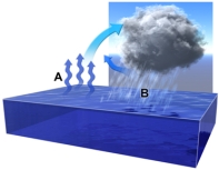
A)warm vapor at A is caused by the heat released in condensation at point B
B)warm vapor at A is likely not related to condensation at point B
C)warm vapor at A causes cooling and condenses to liquid water at point B
D)water evaporates at point A,rises,and then cools and condenses at point B
E)vapor and water droplets are the behaving the same way
Question
Question
Question
Question
Question
This diagram suggests that: 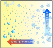
A)ice crystals can form across a range of temperatures at higher altitudes
B)water droplets form across a range of temperatures
C)while rain is failing at lower elevations,ice crystals can exist at higher elevations
D)all of these
E)none of these
A)ice crystals can form across a range of temperatures at higher altitudes
B)water droplets form across a range of temperatures
C)while rain is failing at lower elevations,ice crystals can exist at higher elevations
D)all of these
E)none of these
Question
Arrows on this figure shows flow cells in the atmosphere.Which area(s)would experience heavy precipitation,as results in rain forests? 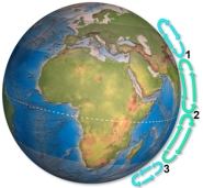
A)1
B)2
C)3
D)1 and 2
E)1 and 3
A)1
B)2
C)3
D)1 and 2
E)1 and 3
Question
Question
Question
In this model of atmospheric water,why is location C a desert? 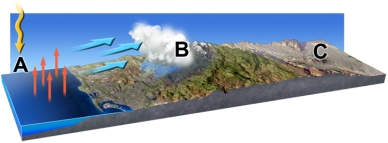
A)the atmosphere cannot rise above the mountains that shadow the area
B)the actual shadow of clouds at B causes cold dry conditions at C
C)the shadow of the mountains keeps plants from growing at C
D)the water vapor sinking at A keeps point C dry
E)moist air is forced to rise and cool over the mountains,decreasing the amount of water vapor available to point C
Question
Question
The Coriolis effect in this figure shows the deflection of cold air as it rushes in to replace hot rising air above a low pressure zone.The Coriolis effect: 
A)usually is evident in local small storms less than a few kilometers wide
B)is responsible for tornados and whirlwinds
C)requires a very large air masses since it requires defection by the Earth's rotation
D)is seen in smoke rising from a building fire
E)all of these
A)usually is evident in local small storms less than a few kilometers wide
B)is responsible for tornados and whirlwinds
C)requires a very large air masses since it requires defection by the Earth's rotation
D)is seen in smoke rising from a building fire
E)all of these
Question
Question
Question
Question
Question
Question
This diagram shows the conditions under which the three phases of water can exist.Which of the following is NOT true? 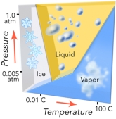
A)increasing temperature can cause ice to become liquid
B)increasing temperature can cause liquid to become vapor
C)at low pressure,increasing temperature can cause ice to become vapor
D)decreasing pressure can convert vapor to ice or a liquid
A)increasing temperature can cause ice to become liquid
B)increasing temperature can cause liquid to become vapor
C)at low pressure,increasing temperature can cause ice to become vapor
D)decreasing pressure can convert vapor to ice or a liquid
Question
This figure shows warmer-than-normal sea-surface temperatures in the eastern Pacific.What condition is illustrated? 
A)monsoon
B)world-wide drought
C)El Niño
D)La Niña
A)monsoon
B)world-wide drought
C)El Niño
D)La Niña
Question
Question
For these ocean currents in the South Atlantic,which of these currents is mostly likely to be a cold current? 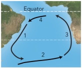
A)1
B)3
C)4
D)both 1 and 3
E)both 2 and 4
A)1
B)3
C)4
D)both 1 and 3
E)both 2 and 4
Question
For these ocean currents in the South Atlantic,which of these currents is mostly likely to be a warm current? 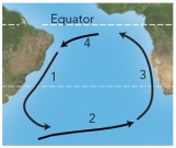
A)1
B)2
C)3
D)both 1 and 3
E)both 2 and 4
A)1
B)2
C)3
D)both 1 and 3
E)both 2 and 4
Question
Question
This figure shows how sunlight strikes the earth during certain times of the year.It is summer: 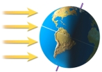
A)in the Northern Hemisphere
B)in the Southern Hemisphere
C)in both the Northern and Southern Hemispheres
D)on the side of the earth facing the Sun
A)in the Northern Hemisphere
B)in the Southern Hemisphere
C)in both the Northern and Southern Hemispheres
D)on the side of the earth facing the Sun
Question
For these ocean currents in the Atlantic,which of these currents is mostly likely to be a warm current? 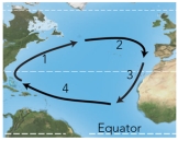
A)1
B)2
C)3
D)both 1 and 3
E)both 2 and 4
A)1
B)2
C)3
D)both 1 and 3
E)both 2 and 4
Question
Question
Question
This figure shows warmer-than-normal sea-surface temperatures in the western Pacific and cooler-than-normal temperatures for the eastern Pacific.What condition is being illustrated? 
A)monsoon
B)world-wide drought
C)El Niño
D)La Niña
A)monsoon
B)world-wide drought
C)El Niño
D)La Niña
Question
The east Australian current is shown by the sweeping arrow flowing south along the continents eastern shoreline.Winds blowing across this current onto land are shown as a series of westward arrows.These winds: 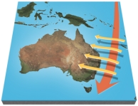
A)are heated and make the eastern side of Australia arid
B)rise over the current and are unaffected
C)pick up moisture and then cause precipitation,allowing rain forests along the coast
D)release moisture and cool the current
A)are heated and make the eastern side of Australia arid
B)rise over the current and are unaffected
C)pick up moisture and then cause precipitation,allowing rain forests along the coast
D)release moisture and cool the current
Question
Question
Question
Question
Question
For these ocean currents in the Atlantic,which of these currents is mostly likely to be a cold current? 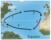
A)1
B)3
C)4
D)both 1 and 3
E)both 2 and 4
A)1
B)3
C)4
D)both 1 and 3
E)both 2 and 4
Question
This figure shows how sunlight strikes the earth during certain times of the year.It is summer: 
A)in the Northern Hemisphere
B)in the Southern Hemisphere
C)in both the Northern and Southern Hemispheres
D)on the side of the earth facing the Sun
A)in the Northern Hemisphere
B)in the Southern Hemisphere
C)in both the Northern and Southern Hemispheres
D)on the side of the earth facing the Sun
Question
Question
Question
Question
The sand dunes shown in this photograph: 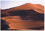
A)are isolated and have well-defined crescent shapes
B)formed in a wet climate based on their shape
C)are part of a complex dune field
D)are loess deposits
E)are inactive because they have been eroded by running water
A)are isolated and have well-defined crescent shapes
B)formed in a wet climate based on their shape
C)are part of a complex dune field
D)are loess deposits
E)are inactive because they have been eroded by running water
Question
Arrows on this figure shows flow cells in the atmosphere.Which area(s)would most likely be a desert? 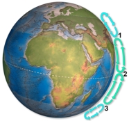
A)1
B)2
C)3
D)1 and 2
E)1 and 3
A)1
B)2
C)3
D)1 and 2
E)1 and 3
Question
Question
Question
Question
Question
This wind-blown dust deposit (loess)in Illinois: 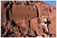
A)was deposited by a huge flood of seawater that covered the land at the time of the dinosaurs
B)began as clay and silt that were produced by grinding of rocks along ice-age glaciers
C)forms a world-wide layer associated with a well-known extinction of dinosaurs
D)all of these
A)was deposited by a huge flood of seawater that covered the land at the time of the dinosaurs
B)began as clay and silt that were produced by grinding of rocks along ice-age glaciers
C)forms a world-wide layer associated with a well-known extinction of dinosaurs
D)all of these
Question
Question
Question
Question
What desert feature is shown in this photograph? 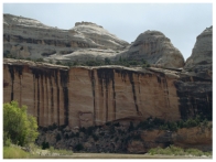
A)alluvial fan
B)playa
C)caliche
D)desert wash
E)natural stain
A)alluvial fan
B)playa
C)caliche
D)desert wash
E)natural stain
Question
Question
Dust storms,like the one shown in this satellite image near North Africa,can transport dust over maximum distances of: 
A)10 kilometers
B)50 to 90 kilometers
C)100 kilometers because of the Coriolis effect
D)several hundred kilometers
E)thousands of kilometers
A)10 kilometers
B)50 to 90 kilometers
C)100 kilometers because of the Coriolis effect
D)several hundred kilometers
E)thousands of kilometers
Question
Question
The area marked by number 2 on this figure is a desert primarily because: 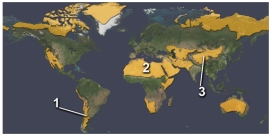
A)it is in the rainshadow of a mountain range
B)it is cooled by cold currents from the Arctic
C)it is within the interior of a continent
D)it experiences dry,descending air in the subtropics
A)it is in the rainshadow of a mountain range
B)it is cooled by cold currents from the Arctic
C)it is within the interior of a continent
D)it experiences dry,descending air in the subtropics
Question
Question
This photograph shows an accumulation of calcium carbonate in the soil.What desert feature is it? 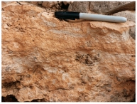
A)alluvial fan
B)playa
C)caliche
D)desert wash
E)natural stain
A)alluvial fan
B)playa
C)caliche
D)desert wash
E)natural stain
Question
Question
These pillars are remnants of layers,most of which have been stripped away by wind erosion.If this occurred in less than five years you might reasonably conclude that: 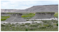
A)the pillars are remnants of volcanic necks
B)this area recently has become a productive place to produce agriculture
C)there must have been drought,overgrazing,or some short-term climatic change
D)this area was originally a lake
A)the pillars are remnants of volcanic necks
B)this area recently has become a productive place to produce agriculture
C)there must have been drought,overgrazing,or some short-term climatic change
D)this area was originally a lake
Question
Question
Which of the following landscape features is shown in this photograph? 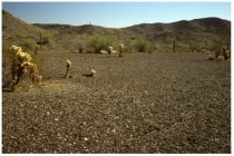
A)caliche
B)playa
C)sand dune
D)desert pavement
E)rain forest
A)caliche
B)playa
C)sand dune
D)desert pavement
E)rain forest
Question
This graph shows an interpretation of temperatures based on the lengths of glaciers.This graph indicates that: 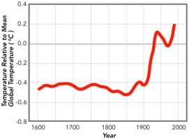
A)climate has been changing over the past hundred years
B)overall,air temperatures have been increasing since around 1900
C)from 1600 to 1900 the Earth was dramatically colder than it has been since 1900
D)all of these
A)climate has been changing over the past hundred years
B)overall,air temperatures have been increasing since around 1900
C)from 1600 to 1900 the Earth was dramatically colder than it has been since 1900
D)all of these
Question
These data,derived from ice cores,indicate that: 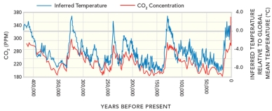
A)temperatures and CO2 concentration have remained constant until very recent inputs from humans
B)several times in the past humans have perturbed the natural environment causing natural increases in CO2 and temperature
C)temperature increased,followed by an increase in CO2
D)all of these
A)temperatures and CO2 concentration have remained constant until very recent inputs from humans
B)several times in the past humans have perturbed the natural environment causing natural increases in CO2 and temperature
C)temperature increased,followed by an increase in CO2
D)all of these
Question
This graph shows one estimate of average air temperatures.This graph indicates that: 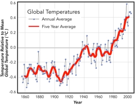
A)humans and greenhouse gases are responsible for global warming
B)overall,air temperatures have been increasing since around 1910
C)Earth was cooler in the last part of the 1800s than it was in the first half of the 1900s
D)all of these
A)humans and greenhouse gases are responsible for global warming
B)overall,air temperatures have been increasing since around 1910
C)Earth was cooler in the last part of the 1800s than it was in the first half of the 1900s
D)all of these
Question
This plot of ice-core data shows measurements of CO2 content and interpretation of temperatures.These data show: 
A)that CO2 concentration and temperature generally increase and decrease over the same time periods
B)that most temperature changes on this graph are due to CO2 introduced by humans
C)that current temperatures are the highest they have been
D)all of these
A)that CO2 concentration and temperature generally increase and decrease over the same time periods
B)that most temperature changes on this graph are due to CO2 introduced by humans
C)that current temperatures are the highest they have been
D)all of these
Question
Question
Question
Question
This graph shows an interpretation of temperatures based on the change in isotopes in ice-core data.This graph implies that: 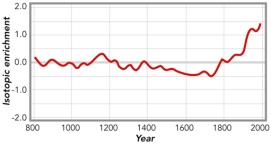
A)current temperatures are by far the hottest based on this record
B)atmospheric warming started as early as the late 1700s
C)the coolest time period on this data set was from around 1500 to the last part of the 1700s
D)all of these
A)current temperatures are by far the hottest based on this record
B)atmospheric warming started as early as the late 1700s
C)the coolest time period on this data set was from around 1500 to the last part of the 1700s
D)all of these
Question
Question
Question
What desert feature is shown in this photograph? 
A)alluvial fan
B)playa
C)caliche
D)desert wash
E)desert varnish
A)alluvial fan
B)playa
C)caliche
D)desert wash
E)desert varnish
Question
Question
Question
Question
This graph shows an interpretation of temperatures based on tree-ring data.This graph implies that: 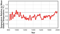
A)current temperatures are by far the hottest in this record
B)atmospheric warming started well before 1900
C)climate was stable prior to 1800
D)all of these
A)current temperatures are by far the hottest in this record
B)atmospheric warming started well before 1900
C)climate was stable prior to 1800
D)all of these
Question
Question
Question
How does this desert feature form? 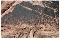
A)the Sun bakes and darkens the rock
B)wind coats the surface with material that becomes iron and manganese oxides
C)blowing sand removes material from the rock face
D)vandals painted dark paint over the artwork
A)the Sun bakes and darkens the rock
B)wind coats the surface with material that becomes iron and manganese oxides
C)blowing sand removes material from the rock face
D)vandals painted dark paint over the artwork
Question
Which of the following landscape features is shown in this photograph? 
A)pediment
B)playa
C)sand dune
D)dry wash
E)alluvial fan
A)pediment
B)playa
C)sand dune
D)dry wash
E)alluvial fan

Unlock Deck
Sign up to unlock the cards in this deck!
Unlock Deck
Unlock Deck
1/85
Play
Full screen (f)
Deck 13: Climate, weather, and Their Influences on Geology
1
In a low-pressure system,the Coriolis effect causes wind to rotate:
A)clockwise in the southern hemisphere
B)clockwise in the northern hemisphere
C)counterclockwise in the southern hemisphere
D)counterclockwise in both hemispheres
A)clockwise in the southern hemisphere
B)clockwise in the northern hemisphere
C)counterclockwise in the southern hemisphere
D)counterclockwise in both hemispheres
A
2
The tropics are regions characterized by:
A)high-pressure air masses that rise and cause abundant precipitation
B)low-pressure air masses that rise and cause abundant precipitation
C)low-pressure air masses that descend,limiting the amount of precipitation
D)high-pressure air masses that descend,limiting the amount of precipitation
E)none of these
B
3
What is the relationship between water vapor at point A and water droplets at point B?
A)warm vapor at A is caused by the heat released in condensation at point B
B)warm vapor at A is likely not related to condensation at point B
C)warm vapor at A causes cooling and condenses to liquid water at point B
D)water evaporates at point A,rises,and then cools and condenses at point B
E)vapor and water droplets are the behaving the same way
D
4
Global belts of prevailing winds are caused by:
A)the lower spin velocity and higher atmospheric solar heating at the equator
B)the higher spin velocity and lower atmospheric solar heating at the equator
C)the higher spin velocity and higher atmospheric solar heating at the equator
D)the lower spin velocity and lower atmospheric solar heating at the equator
E)none of these
Unlock Deck
Unlock for access to all 85 flashcards in this deck.
Unlock Deck
k this deck
5
In a low pressure system:
A)atmospheric pressure is higher than in surrounding regions
B)winds diverge from the center of sinking air masses,and fair weather is common
C)sinking air heats up and causes rain
D)rising air cools and condenses,causing rain
A)atmospheric pressure is higher than in surrounding regions
B)winds diverge from the center of sinking air masses,and fair weather is common
C)sinking air heats up and causes rain
D)rising air cools and condenses,causing rain
Unlock Deck
Unlock for access to all 85 flashcards in this deck.
Unlock Deck
k this deck
6
The Coriolis effect in the atmosphere is due to:
A)centrifugal force that causes water to bulge along the poles
B)the atmosphere rotating faster at the equator than at the poles
C)warm air flowing around the equator due to the Earth's rotation
D)cool air rising from the equator and flowing east and west
A)centrifugal force that causes water to bulge along the poles
B)the atmosphere rotating faster at the equator than at the poles
C)warm air flowing around the equator due to the Earth's rotation
D)cool air rising from the equator and flowing east and west
Unlock Deck
Unlock for access to all 85 flashcards in this deck.
Unlock Deck
k this deck
7
Supercell thunderstorms are characterized by:
A)downward-moving winds (called microbursts)along the front of the storm
B)a strong central updraft that may produce tornadoes
C)an anvil shape
D)all of these
A)downward-moving winds (called microbursts)along the front of the storm
B)a strong central updraft that may produce tornadoes
C)an anvil shape
D)all of these
Unlock Deck
Unlock for access to all 85 flashcards in this deck.
Unlock Deck
k this deck
8
This diagram suggests that:
A)ice crystals can form across a range of temperatures at higher altitudes
B)water droplets form across a range of temperatures
C)while rain is failing at lower elevations,ice crystals can exist at higher elevations
D)all of these
E)none of these
A)ice crystals can form across a range of temperatures at higher altitudes
B)water droplets form across a range of temperatures
C)while rain is failing at lower elevations,ice crystals can exist at higher elevations
D)all of these
E)none of these
Unlock Deck
Unlock for access to all 85 flashcards in this deck.
Unlock Deck
k this deck
9
Arrows on this figure shows flow cells in the atmosphere.Which area(s)would experience heavy precipitation,as results in rain forests?
A)1
B)2
C)3
D)1 and 2
E)1 and 3
A)1
B)2
C)3
D)1 and 2
E)1 and 3
Unlock Deck
Unlock for access to all 85 flashcards in this deck.
Unlock Deck
k this deck
10
Which of the following helps cause hurricanes to grow and be sustained?
A)cold water droplets are ripped from the ocean surface by the winds and evaporate causing heating
B)warm surface water evaporates into warm rising water vapor,which condenses
C)warm surface water draws down cold air from above,causing a cell to form
D)cold surface water evaporates when heated air is blown across the water surface
E)none of these
Unlock Deck
Unlock for access to all 85 flashcards in this deck.
Unlock Deck
k this deck
11
Which of the following settings is most likely to have high precipitation?
A)cold polar air that descends and heats up
B)a site where two large-scale circulation patterns flow away from each other,causing air to descend
C)a site where two large-scale circulation patterns converge,causing air to rise and cool
D)none of these
A)cold polar air that descends and heats up
B)a site where two large-scale circulation patterns flow away from each other,causing air to descend
C)a site where two large-scale circulation patterns converge,causing air to rise and cool
D)none of these
Unlock Deck
Unlock for access to all 85 flashcards in this deck.
Unlock Deck
k this deck
12
In this model of atmospheric water,why is location C a desert?
A)the atmosphere cannot rise above the mountains that shadow the area
B)the actual shadow of clouds at B causes cold dry conditions at C
C)the shadow of the mountains keeps plants from growing at C
D)the water vapor sinking at A keeps point C dry
E)moist air is forced to rise and cool over the mountains,decreasing the amount of water vapor available to point C
Unlock Deck
Unlock for access to all 85 flashcards in this deck.
Unlock Deck
k this deck
13
In a high pressure system:
A)atmospheric pressure is lower than in surrounding regions
B)winds diverge from the center of sinking air masses,and fair weather is common
C)sinking air increases the water vapor and causes high amounts of rain
D)rising air heats up and condenses,causing rain
E)all of these
A)atmospheric pressure is lower than in surrounding regions
B)winds diverge from the center of sinking air masses,and fair weather is common
C)sinking air increases the water vapor and causes high amounts of rain
D)rising air heats up and condenses,causing rain
E)all of these
Unlock Deck
Unlock for access to all 85 flashcards in this deck.
Unlock Deck
k this deck
14
The Coriolis effect in this figure shows the deflection of cold air as it rushes in to replace hot rising air above a low pressure zone.The Coriolis effect:
A)usually is evident in local small storms less than a few kilometers wide
B)is responsible for tornados and whirlwinds
C)requires a very large air masses since it requires defection by the Earth's rotation
D)is seen in smoke rising from a building fire
E)all of these
A)usually is evident in local small storms less than a few kilometers wide
B)is responsible for tornados and whirlwinds
C)requires a very large air masses since it requires defection by the Earth's rotation
D)is seen in smoke rising from a building fire
E)all of these
Unlock Deck
Unlock for access to all 85 flashcards in this deck.
Unlock Deck
k this deck
15
What topic was NOT discussed in the opening of the climate chapter?
A)the monsoon of India
B)the role of the Himalaya in climate
C)the Brahmaputra River of India and Bangladesh
D)all of these were discussed
A)the monsoon of India
B)the role of the Himalaya in climate
C)the Brahmaputra River of India and Bangladesh
D)all of these were discussed
Unlock Deck
Unlock for access to all 85 flashcards in this deck.
Unlock Deck
k this deck
16
Atmospheric pressure decreases with increasing altitude due to:
A)the removal of oxygen by Earth's rotational spin
B)an increase in gravitational force away from Earth
C)an increase in water vapor away from the surface
D)the reduction of ozone content by solar radiation
E)a decrease in the thickness and density of air on top
A)the removal of oxygen by Earth's rotational spin
B)an increase in gravitational force away from Earth
C)an increase in water vapor away from the surface
D)the reduction of ozone content by solar radiation
E)a decrease in the thickness and density of air on top
Unlock Deck
Unlock for access to all 85 flashcards in this deck.
Unlock Deck
k this deck
17
Atmospheric pressure is generally:
A)lower at lower altitude
B)lower at higher altitude
C)highest when the wind is blowing
D)lowest when the wind is blowing
A)lower at lower altitude
B)lower at higher altitude
C)highest when the wind is blowing
D)lowest when the wind is blowing
Unlock Deck
Unlock for access to all 85 flashcards in this deck.
Unlock Deck
k this deck
18
Most equatorial regions are warmer than the rest of Earth because of:
A)Earth's daily rotation
B)Earth's orbit around Sun
C)tilt of Earth's axis of rotation
D)none of these
A)Earth's daily rotation
B)Earth's orbit around Sun
C)tilt of Earth's axis of rotation
D)none of these
Unlock Deck
Unlock for access to all 85 flashcards in this deck.
Unlock Deck
k this deck
19
As described in the chapter opener,the word monsoon refers to:
A)a decade-long period of drought
B)a decade-long period of rainfall
C)the appearance of the moon earlier than expected
D)winds that reverse direction,depending on the season
A)a decade-long period of drought
B)a decade-long period of rainfall
C)the appearance of the moon earlier than expected
D)winds that reverse direction,depending on the season
Unlock Deck
Unlock for access to all 85 flashcards in this deck.
Unlock Deck
k this deck
20
This diagram shows the conditions under which the three phases of water can exist.Which of the following is NOT true?
A)increasing temperature can cause ice to become liquid
B)increasing temperature can cause liquid to become vapor
C)at low pressure,increasing temperature can cause ice to become vapor
D)decreasing pressure can convert vapor to ice or a liquid
A)increasing temperature can cause ice to become liquid
B)increasing temperature can cause liquid to become vapor
C)at low pressure,increasing temperature can cause ice to become vapor
D)decreasing pressure can convert vapor to ice or a liquid
Unlock Deck
Unlock for access to all 85 flashcards in this deck.
Unlock Deck
k this deck
21
This figure shows warmer-than-normal sea-surface temperatures in the eastern Pacific.What condition is illustrated?
A)monsoon
B)world-wide drought
C)El Niño
D)La Niña
A)monsoon
B)world-wide drought
C)El Niño
D)La Niña
Unlock Deck
Unlock for access to all 85 flashcards in this deck.
Unlock Deck
k this deck
22
Surface ocean currents circulate in ocean basins:
A)clockwise in the northern hemisphere
B)clockwise in the southern hemisphere
C)counterclockwise in the northern hemisphere
D)circulation directions are not systematic
A)clockwise in the northern hemisphere
B)clockwise in the southern hemisphere
C)counterclockwise in the northern hemisphere
D)circulation directions are not systematic
Unlock Deck
Unlock for access to all 85 flashcards in this deck.
Unlock Deck
k this deck
23
For these ocean currents in the South Atlantic,which of these currents is mostly likely to be a cold current?
A)1
B)3
C)4
D)both 1 and 3
E)both 2 and 4
A)1
B)3
C)4
D)both 1 and 3
E)both 2 and 4
Unlock Deck
Unlock for access to all 85 flashcards in this deck.
Unlock Deck
k this deck
24
For these ocean currents in the South Atlantic,which of these currents is mostly likely to be a warm current?
A)1
B)2
C)3
D)both 1 and 3
E)both 2 and 4
A)1
B)2
C)3
D)both 1 and 3
E)both 2 and 4
Unlock Deck
Unlock for access to all 85 flashcards in this deck.
Unlock Deck
k this deck
25
The ocean current known as the Gulf Stream in the Atlantic Ocean is a:
A)warm current flowing north from the equator
B)cold current flowing north from the equator
C)warm equatorial current flowing east into the Gulf of Mexico
D)deep-ocean current that controls fish abundances in the southern hemisphere
E)none of these
A)warm current flowing north from the equator
B)cold current flowing north from the equator
C)warm equatorial current flowing east into the Gulf of Mexico
D)deep-ocean current that controls fish abundances in the southern hemisphere
E)none of these
Unlock Deck
Unlock for access to all 85 flashcards in this deck.
Unlock Deck
k this deck
26
This figure shows how sunlight strikes the earth during certain times of the year.It is summer:
A)in the Northern Hemisphere
B)in the Southern Hemisphere
C)in both the Northern and Southern Hemispheres
D)on the side of the earth facing the Sun
A)in the Northern Hemisphere
B)in the Southern Hemisphere
C)in both the Northern and Southern Hemispheres
D)on the side of the earth facing the Sun
Unlock Deck
Unlock for access to all 85 flashcards in this deck.
Unlock Deck
k this deck
27
For these ocean currents in the Atlantic,which of these currents is mostly likely to be a warm current?
A)1
B)2
C)3
D)both 1 and 3
E)both 2 and 4
A)1
B)2
C)3
D)both 1 and 3
E)both 2 and 4
Unlock Deck
Unlock for access to all 85 flashcards in this deck.
Unlock Deck
k this deck
28
The thermohaline conveyor is important in the North Pacific because:
A)it warms the coast of Alaska,allowing longer growing seasons
B)it brings deep nutrient-rich water to the surface
C)it decreases surface water temperatures,preventing hurricanes
D)it brings warmer water deep into the Pacific basin,recharging nutrients
A)it warms the coast of Alaska,allowing longer growing seasons
B)it brings deep nutrient-rich water to the surface
C)it decreases surface water temperatures,preventing hurricanes
D)it brings warmer water deep into the Pacific basin,recharging nutrients
Unlock Deck
Unlock for access to all 85 flashcards in this deck.
Unlock Deck
k this deck
29
El Niño is a condition that brings increased precipitation to the eastern Pacific Ocean basin when:
A)weakening of an ocean current results in cooler sea temperatures in the eastern Pacific
B)strengthening of an ocean current results in warmer sea temperatures in the eastern Pacific
C)an ocean current reverses direction,resulting in cooler sea temperatures in the eastern Pacific
D)heating occurs in deserts of the American Southwest during summer months
E)none of these
Unlock Deck
Unlock for access to all 85 flashcards in this deck.
Unlock Deck
k this deck
30
This figure shows warmer-than-normal sea-surface temperatures in the western Pacific and cooler-than-normal temperatures for the eastern Pacific.What condition is being illustrated?
A)monsoon
B)world-wide drought
C)El Niño
D)La Niña
A)monsoon
B)world-wide drought
C)El Niño
D)La Niña
Unlock Deck
Unlock for access to all 85 flashcards in this deck.
Unlock Deck
k this deck
31
The east Australian current is shown by the sweeping arrow flowing south along the continents eastern shoreline.Winds blowing across this current onto land are shown as a series of westward arrows.These winds:
A)are heated and make the eastern side of Australia arid
B)rise over the current and are unaffected
C)pick up moisture and then cause precipitation,allowing rain forests along the coast
D)release moisture and cool the current
A)are heated and make the eastern side of Australia arid
B)rise over the current and are unaffected
C)pick up moisture and then cause precipitation,allowing rain forests along the coast
D)release moisture and cool the current
Unlock Deck
Unlock for access to all 85 flashcards in this deck.
Unlock Deck
k this deck
32
Counter currents near the equator flow mostly:
A)south from the poles to the equator
B)north from the equator to the poles
C)east-west,parallel to the equator
D)counterclockwise to balance the Coriolis effect
E)none of these
A)south from the poles to the equator
B)north from the equator to the poles
C)east-west,parallel to the equator
D)counterclockwise to balance the Coriolis effect
E)none of these
Unlock Deck
Unlock for access to all 85 flashcards in this deck.
Unlock Deck
k this deck
33
A monsoon is a:
A)hurricane in the Atlantic Ocean
B)typhoon in the Pacific Ocean
C)large,supercell thunderstorm
D)seasonal change in wind direction
A)hurricane in the Atlantic Ocean
B)typhoon in the Pacific Ocean
C)large,supercell thunderstorm
D)seasonal change in wind direction
Unlock Deck
Unlock for access to all 85 flashcards in this deck.
Unlock Deck
k this deck
34
The thermohaline conveyor is driven by:
A)warm,less saline surface water that circulates at the equator
B)cold less saline water that flows from melting glaciers in Greenland
C)warmer surface water that rises in the Indian Ocean
D)warm saline water that sinks in the North Atlantic
E)warm deep water that rises in the North Pacific
A)warm,less saline surface water that circulates at the equator
B)cold less saline water that flows from melting glaciers in Greenland
C)warmer surface water that rises in the Indian Ocean
D)warm saline water that sinks in the North Atlantic
E)warm deep water that rises in the North Pacific
Unlock Deck
Unlock for access to all 85 flashcards in this deck.
Unlock Deck
k this deck
35
Which of the following are NOT associated with a hurricane?
A)strong winds and heavy rainfall
B)a mound of water (storm surge)pushed ahead of the storm
C)high atmospheric pressure
D)a relatively calm area in the center of the storm
E)all of these are associated with a hurricane
A)strong winds and heavy rainfall
B)a mound of water (storm surge)pushed ahead of the storm
C)high atmospheric pressure
D)a relatively calm area in the center of the storm
E)all of these are associated with a hurricane
Unlock Deck
Unlock for access to all 85 flashcards in this deck.
Unlock Deck
k this deck
36
For these ocean currents in the Atlantic,which of these currents is mostly likely to be a cold current?
A)1
B)3
C)4
D)both 1 and 3
E)both 2 and 4
A)1
B)3
C)4
D)both 1 and 3
E)both 2 and 4
Unlock Deck
Unlock for access to all 85 flashcards in this deck.
Unlock Deck
k this deck
37
This figure shows how sunlight strikes the earth during certain times of the year.It is summer:
A)in the Northern Hemisphere
B)in the Southern Hemisphere
C)in both the Northern and Southern Hemispheres
D)on the side of the earth facing the Sun
A)in the Northern Hemisphere
B)in the Southern Hemisphere
C)in both the Northern and Southern Hemispheres
D)on the side of the earth facing the Sun
Unlock Deck
Unlock for access to all 85 flashcards in this deck.
Unlock Deck
k this deck
38
Tornado Alley is a region in the United States comprising:
A)Florida,North Carolina,South Carolina
B)Texas,Oklahoma,Kansas,Nebraska
C)Delaware,Maryland
D)Michigan,Wisconsin,Ohio
E)Kentucky,Alabama,Tennessee
A)Florida,North Carolina,South Carolina
B)Texas,Oklahoma,Kansas,Nebraska
C)Delaware,Maryland
D)Michigan,Wisconsin,Ohio
E)Kentucky,Alabama,Tennessee
Unlock Deck
Unlock for access to all 85 flashcards in this deck.
Unlock Deck
k this deck
39
The Indian monsoon occurs because:
A)the Sonoran Desert heats up the Four Corners area in the summer
B)the Bay of Bengal heats up in the summer
C)Tibet becomes colder,causing a southward flow of cold,wet air toward India
D)water vapor from the Arabian Sea and Bay of Bengal flows over India
A)the Sonoran Desert heats up the Four Corners area in the summer
B)the Bay of Bengal heats up in the summer
C)Tibet becomes colder,causing a southward flow of cold,wet air toward India
D)water vapor from the Arabian Sea and Bay of Bengal flows over India
Unlock Deck
Unlock for access to all 85 flashcards in this deck.
Unlock Deck
k this deck
40
Monsoons are caused by
A)seasonal heating of land masses in summer that changes wind directions
B)seasonal changes in the temperature of deep-water currents
C)changes in rain forest density that in turn change evaporation rates
D)high winds that flow from mountains toward oceans
A)seasonal heating of land masses in summer that changes wind directions
B)seasonal changes in the temperature of deep-water currents
C)changes in rain forest density that in turn change evaporation rates
D)high winds that flow from mountains toward oceans
Unlock Deck
Unlock for access to all 85 flashcards in this deck.
Unlock Deck
k this deck
41
The sand dunes shown in this photograph:
A)are isolated and have well-defined crescent shapes
B)formed in a wet climate based on their shape
C)are part of a complex dune field
D)are loess deposits
E)are inactive because they have been eroded by running water
A)are isolated and have well-defined crescent shapes
B)formed in a wet climate based on their shape
C)are part of a complex dune field
D)are loess deposits
E)are inactive because they have been eroded by running water
Unlock Deck
Unlock for access to all 85 flashcards in this deck.
Unlock Deck
k this deck
42
Arrows on this figure shows flow cells in the atmosphere.Which area(s)would most likely be a desert?
A)1
B)2
C)3
D)1 and 2
E)1 and 3
A)1
B)2
C)3
D)1 and 2
E)1 and 3
Unlock Deck
Unlock for access to all 85 flashcards in this deck.
Unlock Deck
k this deck
43
Drought is an extended period of reduced precipitation and can be caused by:
A)atypical high-pressure weather systems
B)changes in ocean currents
C)changes in wind directions for a long time
D)all of these
A)atypical high-pressure weather systems
B)changes in ocean currents
C)changes in wind directions for a long time
D)all of these
Unlock Deck
Unlock for access to all 85 flashcards in this deck.
Unlock Deck
k this deck
44
Which of the following is NOT a setting that can form a desert?
A)near cold,upwelling ocean currents
B)in the subtropics due to atmosphere circulation patterns
C)in a rain shadow of a mountain range
D)in cold,dry polar regions
E)all of these are settings that can form deserts
A)near cold,upwelling ocean currents
B)in the subtropics due to atmosphere circulation patterns
C)in a rain shadow of a mountain range
D)in cold,dry polar regions
E)all of these are settings that can form deserts
Unlock Deck
Unlock for access to all 85 flashcards in this deck.
Unlock Deck
k this deck
45
What is the main setting in which rain forests occur?
A)near the equator
B)at 30 north and 30 south latitude
C)at 45 north and 45 south latitude
D)in the interior of large continents,especially Asia
A)near the equator
B)at 30 north and 30 south latitude
C)at 45 north and 45 south latitude
D)in the interior of large continents,especially Asia
Unlock Deck
Unlock for access to all 85 flashcards in this deck.
Unlock Deck
k this deck
46
Tropical rain forests are clustered near the Intertropical Convergence Zone,which is:
A)a low and very hot area of land where one continental plate converges with another
B)a low and very hot area of land where two oceanic plates converge
C)almost exactly along the equator due to maximum solar radiation converging on plants
D)a curved boundary where winds converge near the equator
A)a low and very hot area of land where one continental plate converges with another
B)a low and very hot area of land where two oceanic plates converge
C)almost exactly along the equator due to maximum solar radiation converging on plants
D)a curved boundary where winds converge near the equator
Unlock Deck
Unlock for access to all 85 flashcards in this deck.
Unlock Deck
k this deck
47
This wind-blown dust deposit (loess)in Illinois:
A)was deposited by a huge flood of seawater that covered the land at the time of the dinosaurs
B)began as clay and silt that were produced by grinding of rocks along ice-age glaciers
C)forms a world-wide layer associated with a well-known extinction of dinosaurs
D)all of these
A)was deposited by a huge flood of seawater that covered the land at the time of the dinosaurs
B)began as clay and silt that were produced by grinding of rocks along ice-age glaciers
C)forms a world-wide layer associated with a well-known extinction of dinosaurs
D)all of these
Unlock Deck
Unlock for access to all 85 flashcards in this deck.
Unlock Deck
k this deck
48
Which of the following is a key aspect of all deserts?
A)they receive less precipitation than they lose to evaporation and other processes
B)they receive less than 25 centimeters of rainfall per year
C)the largest ones are in the northern hemisphere
D)all of these
A)they receive less precipitation than they lose to evaporation and other processes
B)they receive less than 25 centimeters of rainfall per year
C)the largest ones are in the northern hemisphere
D)all of these
Unlock Deck
Unlock for access to all 85 flashcards in this deck.
Unlock Deck
k this deck
49
How do rain forests influence ecology?
A)materials are washed out of the area and so there is little recycling of nutrients
B)rain forests can take up large amounts of carbon dioxide and so act as a buffer against climate change
C)plants capture solar energy and so cause the ground to become warmer and drier
D)most of the species in rain forests are near the ground surface rather than in the tree-top canopy
E)all of these
Unlock Deck
Unlock for access to all 85 flashcards in this deck.
Unlock Deck
k this deck
50
What is desertification?
A)when a desert changes to some other environment
B)when a desert suffers increased erosion due to loss of plants
C)when grasslands or some other ecology is converted into a desert
D)the deposition of one layer of desert sand over another
A)when a desert changes to some other environment
B)when a desert suffers increased erosion due to loss of plants
C)when grasslands or some other ecology is converted into a desert
D)the deposition of one layer of desert sand over another
Unlock Deck
Unlock for access to all 85 flashcards in this deck.
Unlock Deck
k this deck
51
What desert feature is shown in this photograph?
A)alluvial fan
B)playa
C)caliche
D)desert wash
E)natural stain
A)alluvial fan
B)playa
C)caliche
D)desert wash
E)natural stain
Unlock Deck
Unlock for access to all 85 flashcards in this deck.
Unlock Deck
k this deck
52
Which of the following is NOT a reason why rain forests are disappearing?
A)trees are cleared for small farms so that people can live off the land
B)cattle ranching
C)commercial logging for tropical hardwoods,such as mahogany
D)construction of dams for hydroelectric power
E)all of these are reasons why rain forests are disappearing
A)trees are cleared for small farms so that people can live off the land
B)cattle ranching
C)commercial logging for tropical hardwoods,such as mahogany
D)construction of dams for hydroelectric power
E)all of these are reasons why rain forests are disappearing
Unlock Deck
Unlock for access to all 85 flashcards in this deck.
Unlock Deck
k this deck
53
Dust storms,like the one shown in this satellite image near North Africa,can transport dust over maximum distances of:
A)10 kilometers
B)50 to 90 kilometers
C)100 kilometers because of the Coriolis effect
D)several hundred kilometers
E)thousands of kilometers
A)10 kilometers
B)50 to 90 kilometers
C)100 kilometers because of the Coriolis effect
D)several hundred kilometers
E)thousands of kilometers
Unlock Deck
Unlock for access to all 85 flashcards in this deck.
Unlock Deck
k this deck
54
Which of the following is NOT characteristic of a tropical rain forest?
A)high annual rainfall
B)freezing temperatures during only two months in the winter
C)abundance of plant and animal life
D)diversity of species
E)all of these are characteristic of a tropical rain forest
A)high annual rainfall
B)freezing temperatures during only two months in the winter
C)abundance of plant and animal life
D)diversity of species
E)all of these are characteristic of a tropical rain forest
Unlock Deck
Unlock for access to all 85 flashcards in this deck.
Unlock Deck
k this deck
55
The area marked by number 2 on this figure is a desert primarily because:
A)it is in the rainshadow of a mountain range
B)it is cooled by cold currents from the Arctic
C)it is within the interior of a continent
D)it experiences dry,descending air in the subtropics
A)it is in the rainshadow of a mountain range
B)it is cooled by cold currents from the Arctic
C)it is within the interior of a continent
D)it experiences dry,descending air in the subtropics
Unlock Deck
Unlock for access to all 85 flashcards in this deck.
Unlock Deck
k this deck
56
Where do most deserts and other arid lands occur:
A)along the equator
B)near the poles
C)in the Southern Hemisphere
D)in the subtropics
A)along the equator
B)near the poles
C)in the Southern Hemisphere
D)in the subtropics
Unlock Deck
Unlock for access to all 85 flashcards in this deck.
Unlock Deck
k this deck
57
This photograph shows an accumulation of calcium carbonate in the soil.What desert feature is it?
A)alluvial fan
B)playa
C)caliche
D)desert wash
E)natural stain
A)alluvial fan
B)playa
C)caliche
D)desert wash
E)natural stain
Unlock Deck
Unlock for access to all 85 flashcards in this deck.
Unlock Deck
k this deck
58
Wind moves sediment by:
A)bouncing sand grains along the surface
B)rolling sand grains along the surface
C)carrying finer material,like dust and silt,in air currents
D)all of these
A)bouncing sand grains along the surface
B)rolling sand grains along the surface
C)carrying finer material,like dust and silt,in air currents
D)all of these
Unlock Deck
Unlock for access to all 85 flashcards in this deck.
Unlock Deck
k this deck
59
These pillars are remnants of layers,most of which have been stripped away by wind erosion.If this occurred in less than five years you might reasonably conclude that:
A)the pillars are remnants of volcanic necks
B)this area recently has become a productive place to produce agriculture
C)there must have been drought,overgrazing,or some short-term climatic change
D)this area was originally a lake
A)the pillars are remnants of volcanic necks
B)this area recently has become a productive place to produce agriculture
C)there must have been drought,overgrazing,or some short-term climatic change
D)this area was originally a lake
Unlock Deck
Unlock for access to all 85 flashcards in this deck.
Unlock Deck
k this deck
60
The subtropics at 30 north and south of the equator are characterized by arid lands.This is primarily a result of:
A)rising hot air caused by solar heating in these zones
B)descending hot air that heats the ground
C)descending,dry air that is part of a cell that originates at the equator
D)rising cool,dry air that flows in a cell to the equator
E)polar air that flows towards the equator
A)rising hot air caused by solar heating in these zones
B)descending hot air that heats the ground
C)descending,dry air that is part of a cell that originates at the equator
D)rising cool,dry air that flows in a cell to the equator
E)polar air that flows towards the equator
Unlock Deck
Unlock for access to all 85 flashcards in this deck.
Unlock Deck
k this deck
61
Which of the following landscape features is shown in this photograph?
A)caliche
B)playa
C)sand dune
D)desert pavement
E)rain forest
A)caliche
B)playa
C)sand dune
D)desert pavement
E)rain forest
Unlock Deck
Unlock for access to all 85 flashcards in this deck.
Unlock Deck
k this deck
62
This graph shows an interpretation of temperatures based on the lengths of glaciers.This graph indicates that:
A)climate has been changing over the past hundred years
B)overall,air temperatures have been increasing since around 1900
C)from 1600 to 1900 the Earth was dramatically colder than it has been since 1900
D)all of these
A)climate has been changing over the past hundred years
B)overall,air temperatures have been increasing since around 1900
C)from 1600 to 1900 the Earth was dramatically colder than it has been since 1900
D)all of these
Unlock Deck
Unlock for access to all 85 flashcards in this deck.
Unlock Deck
k this deck
63
These data,derived from ice cores,indicate that:
A)temperatures and CO2 concentration have remained constant until very recent inputs from humans
B)several times in the past humans have perturbed the natural environment causing natural increases in CO2 and temperature
C)temperature increased,followed by an increase in CO2
D)all of these
A)temperatures and CO2 concentration have remained constant until very recent inputs from humans
B)several times in the past humans have perturbed the natural environment causing natural increases in CO2 and temperature
C)temperature increased,followed by an increase in CO2
D)all of these
Unlock Deck
Unlock for access to all 85 flashcards in this deck.
Unlock Deck
k this deck
64
This graph shows one estimate of average air temperatures.This graph indicates that:
A)humans and greenhouse gases are responsible for global warming
B)overall,air temperatures have been increasing since around 1910
C)Earth was cooler in the last part of the 1800s than it was in the first half of the 1900s
D)all of these
A)humans and greenhouse gases are responsible for global warming
B)overall,air temperatures have been increasing since around 1910
C)Earth was cooler in the last part of the 1800s than it was in the first half of the 1900s
D)all of these
Unlock Deck
Unlock for access to all 85 flashcards in this deck.
Unlock Deck
k this deck
65
This plot of ice-core data shows measurements of CO2 content and interpretation of temperatures.These data show:
A)that CO2 concentration and temperature generally increase and decrease over the same time periods
B)that most temperature changes on this graph are due to CO2 introduced by humans
C)that current temperatures are the highest they have been
D)all of these
A)that CO2 concentration and temperature generally increase and decrease over the same time periods
B)that most temperature changes on this graph are due to CO2 introduced by humans
C)that current temperatures are the highest they have been
D)all of these
Unlock Deck
Unlock for access to all 85 flashcards in this deck.
Unlock Deck
k this deck
66
Which of the following is a way that plate tectonics can affect climate?
A)mountain ranges intercept wind and water,affecting rainfall amounts
B)rapid seafloor spreading displaces water from the ocean basins
C)tectonic subsidence during earthquakes can cause flooding and change local climates
D)volcanic activity releases CO2 and water vapor that can cause atmospheric warming
E)all of these
Unlock Deck
Unlock for access to all 85 flashcards in this deck.
Unlock Deck
k this deck
67
Which of the following is true about factors that affect where life can exist?
A)water is not very important because plants and animals can live in deserts
B)life is only possible in a limited temperature range,from 10 to 40 C
C)most plants rely on sunlight as a source of energy
D)carbon dioxide does not play an important role in the growth of plants
E)all of these
A)water is not very important because plants and animals can live in deserts
B)life is only possible in a limited temperature range,from 10 to 40 C
C)most plants rely on sunlight as a source of energy
D)carbon dioxide does not play an important role in the growth of plants
E)all of these
Unlock Deck
Unlock for access to all 85 flashcards in this deck.
Unlock Deck
k this deck
68
Based on data collected in Hawaii,since about 1960 the amount of CO2 in the atmosphere has:
A)decreased as more trees are cut down
B)increased and then decreased
C)decreased and then increased
D)consistently increased,except for yearly variations
A)decreased as more trees are cut down
B)increased and then decreased
C)decreased and then increased
D)consistently increased,except for yearly variations
Unlock Deck
Unlock for access to all 85 flashcards in this deck.
Unlock Deck
k this deck
69
This graph shows an interpretation of temperatures based on the change in isotopes in ice-core data.This graph implies that:
A)current temperatures are by far the hottest based on this record
B)atmospheric warming started as early as the late 1700s
C)the coolest time period on this data set was from around 1500 to the last part of the 1700s
D)all of these
A)current temperatures are by far the hottest based on this record
B)atmospheric warming started as early as the late 1700s
C)the coolest time period on this data set was from around 1500 to the last part of the 1700s
D)all of these
Unlock Deck
Unlock for access to all 85 flashcards in this deck.
Unlock Deck
k this deck
70
Which of the following is NOT true about the interaction of sunlight with Earth?
A)most Earth-surface heating comes from sunlight
B)the amount of solar radiation hitting Earth varies due to orbital variations and changes in the Sun's energy output
C)some sunlight is reflected off the atmosphere without heating Earth
D)the Earth can absorb energy and radiate some back into space as infrared energy
E)all of these are true about the interaction of sunlight with Earth
Unlock Deck
Unlock for access to all 85 flashcards in this deck.
Unlock Deck
k this deck
71
What events occurred in 2004,as described by the Connections spread in the textbook?
A)global warming caused severe drought in the Sahara Desert
B)this was the worst year for the destruction of rain forests
C)a large number of tornadoes struck the central U.S.
D)a number of major hurricanes hit the southeastern U.S.
E)none of these
A)global warming caused severe drought in the Sahara Desert
B)this was the worst year for the destruction of rain forests
C)a large number of tornadoes struck the central U.S.
D)a number of major hurricanes hit the southeastern U.S.
E)none of these
Unlock Deck
Unlock for access to all 85 flashcards in this deck.
Unlock Deck
k this deck
72
What desert feature is shown in this photograph?
A)alluvial fan
B)playa
C)caliche
D)desert wash
E)desert varnish
A)alluvial fan
B)playa
C)caliche
D)desert wash
E)desert varnish
Unlock Deck
Unlock for access to all 85 flashcards in this deck.
Unlock Deck
k this deck
73
Which of the following landscape features is NOT common in deserts?
A)alluvial fan
B)playa
C)rock varnish
D)dry wash
E)all of these are common in deserts
A)alluvial fan
B)playa
C)rock varnish
D)dry wash
E)all of these are common in deserts
Unlock Deck
Unlock for access to all 85 flashcards in this deck.
Unlock Deck
k this deck
74
Which of the following is true about a feature that develops in desert landscapes?
A)an alluvial fan forms where a river terrace steepens toward the channel
B)a desert wash typically has some water throughout the year
C)a playa is a gently sloping erosion surface
D)desert pavement takes thousands of years to develop
E)none of these
A)an alluvial fan forms where a river terrace steepens toward the channel
B)a desert wash typically has some water throughout the year
C)a playa is a gently sloping erosion surface
D)desert pavement takes thousands of years to develop
E)none of these
Unlock Deck
Unlock for access to all 85 flashcards in this deck.
Unlock Deck
k this deck
75
Which of the following is NOT a way that plate motions can cause changes in climate?
A)converging plates can form mountains that cause deserts
B)rifting can bring seas into new areas where they were not before
C)rapid seafloor spreading lowers sea level,exposing the continental shelves
D)moving plates can change the patterns of ocean currents
A)converging plates can form mountains that cause deserts
B)rifting can bring seas into new areas where they were not before
C)rapid seafloor spreading lowers sea level,exposing the continental shelves
D)moving plates can change the patterns of ocean currents
Unlock Deck
Unlock for access to all 85 flashcards in this deck.
Unlock Deck
k this deck
76
This graph shows an interpretation of temperatures based on tree-ring data.This graph implies that:
A)current temperatures are by far the hottest in this record
B)atmospheric warming started well before 1900
C)climate was stable prior to 1800
D)all of these
A)current temperatures are by far the hottest in this record
B)atmospheric warming started well before 1900
C)climate was stable prior to 1800
D)all of these
Unlock Deck
Unlock for access to all 85 flashcards in this deck.
Unlock Deck
k this deck
77
Which of the following is true about a feature that develops in desert landscapes?
A)a pediment is a steep surface cut onto unconsolidated sediment
B)rocks can become concentrated on desert surfaces,forming desert pavement
C)caliche is not common in desert soils
D)desert varnish is a dark coating applied to the rocks by Native Americans
E)all of these are true about features that develop in deserts
Unlock Deck
Unlock for access to all 85 flashcards in this deck.
Unlock Deck
k this deck
78
What are some ways that geology controls ecology?
A)steepness of slopes
B)variations in thickness of soil
C)topography
D)whether water runs off the land or sinks into the ground
E)all of these
A)steepness of slopes
B)variations in thickness of soil
C)topography
D)whether water runs off the land or sinks into the ground
E)all of these
Unlock Deck
Unlock for access to all 85 flashcards in this deck.
Unlock Deck
k this deck
79
How does this desert feature form?
A)the Sun bakes and darkens the rock
B)wind coats the surface with material that becomes iron and manganese oxides
C)blowing sand removes material from the rock face
D)vandals painted dark paint over the artwork
A)the Sun bakes and darkens the rock
B)wind coats the surface with material that becomes iron and manganese oxides
C)blowing sand removes material from the rock face
D)vandals painted dark paint over the artwork
Unlock Deck
Unlock for access to all 85 flashcards in this deck.
Unlock Deck
k this deck
80
Which of the following landscape features is shown in this photograph?
A)pediment
B)playa
C)sand dune
D)dry wash
E)alluvial fan
A)pediment
B)playa
C)sand dune
D)dry wash
E)alluvial fan
Unlock Deck
Unlock for access to all 85 flashcards in this deck.
Unlock Deck
k this deck
Unlock Deck
Unlock for access to all 85 flashcards in this deck.


