Deck 11: Mountains, basins, and Continents
Full screen (f)
Question
If you had this type of deformation of a region,it would: 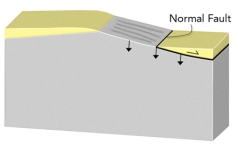
A)thicken the crust and cause subsidence
B)thicken the crust and cause uplift
C)thin the crust and cause subsidence
D)thin the crust and cause uplift
E)none of these
A)thicken the crust and cause subsidence
B)thicken the crust and cause uplift
C)thin the crust and cause subsidence
D)thin the crust and cause uplift
E)none of these
Question
Question
Question
Which of these regions is high because of mantle upwelling near a continental rift? 
A)1,Andes of South America
B)2,East Africa
C)3,Tibet
D)none of these
A)1,Andes of South America
B)2,East Africa
C)3,Tibet
D)none of these
Question
Question
Question
Question
Question
If you had this type of deformation of a region,it would: 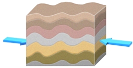
A)thicken the crust and cause subsidence
B)thicken the crust and cause uplift
C)thin the crust and cause subsidence
D)thin the crust and cause uplift
E)none of these
A)thicken the crust and cause subsidence
B)thicken the crust and cause uplift
C)thin the crust and cause subsidence
D)thin the crust and cause uplift
E)none of these
Question
If you had this type of deformation of a region,it would: 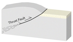
A)thicken the crust and cause subsidence
B)thicken the crust and cause uplift
C)thin the crust and cause subsidence
D)thin the crust and cause uplift
E)none of these
A)thicken the crust and cause subsidence
B)thicken the crust and cause uplift
C)thin the crust and cause subsidence
D)thin the crust and cause uplift
E)none of these
Question
Question
Question
Which of these regions is high because of a continental collision? 
A)1,Andes of South America
B)2,East Africa Rift
C)3,Tibet
D)none of these
A)1,Andes of South America
B)2,East Africa Rift
C)3,Tibet
D)none of these
Question
Which of the following regions below would you predict to have the thickest continental crust? 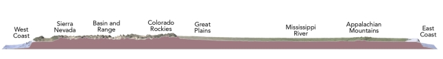
A)the West Coast because it is close to the plate boundary
B)the Colorado Rockies and adjacent Great Plains
C)the area with thick sediments around the Mississippi River
D)the Appalachian Mountains,the dominant range in the eastern U.S.
E)the East Coast because it is a passive margin
A)the West Coast because it is close to the plate boundary
B)the Colorado Rockies and adjacent Great Plains
C)the area with thick sediments around the Mississippi River
D)the Appalachian Mountains,the dominant range in the eastern U.S.
E)the East Coast because it is a passive margin
Question
If you had this type of deformation of a region,it would: 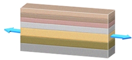
A)thicken the crust and cause subsidence
B)thicken the crust and cause uplift
C)thin the crust and cause subsidence
D)thin the crust and cause uplift
E)none of these
A)thicken the crust and cause subsidence
B)thicken the crust and cause uplift
C)thin the crust and cause subsidence
D)thin the crust and cause uplift
E)none of these
Question
Question
Question
If you erode material off of a region,it would: 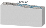
A)thicken the crust
B)thin the crust
C)cause the region to increase in elevation
D)none of these
A)thicken the crust
B)thin the crust
C)cause the region to increase in elevation
D)none of these
Question
Question
Which of these regions is high because of subduction of an oceanic plate? 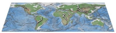
A)1,Andes of South America
B)2,East Africa
C)3,Tibet
D)none of these
A)1,Andes of South America
B)2,East Africa
C)3,Tibet
D)none of these
Question
What type of basin is shown in this figure? 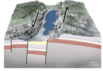
A)passive margin
B)normal-fault basin
C)foreland basin
D)basin along a strike-slip fault
A)passive margin
B)normal-fault basin
C)foreland basin
D)basin along a strike-slip fault
Question
What will happen during movement on these normal faults? 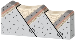
A)the crust will thicken and the region will be uplifted
B)the crust will thin and the region will be uplifted
C)the fault blocks will rotate in the same direction,like books sliding on a shelf
D)the blocks will be uplifted or downdropped with only minor rotation
A)the crust will thicken and the region will be uplifted
B)the crust will thin and the region will be uplifted
C)the fault blocks will rotate in the same direction,like books sliding on a shelf
D)the blocks will be uplifted or downdropped with only minor rotation
Question
In the region shown in this figure,what is the most likely cause for a basin between the arc and continent? 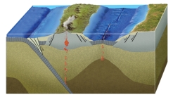
A)it is a foreland basin
B)it is an accretionary prism
C)it formed by back-arc rifting and spreading
D)it formed by strike-slip motion during a continental collision
A)it is a foreland basin
B)it is an accretionary prism
C)it formed by back-arc rifting and spreading
D)it formed by strike-slip motion during a continental collision
Question
Which of these numbered features is a fold and thrust belt? 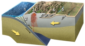
A)1
B)2
C)3
D)4
E)5
A)1
B)2
C)3
D)4
E)5
Question
Question
Why is there a basin associated with some thrust faults? 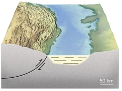
A)thrust faults thin the crust and cause subsidence
B)thrust faults form passive margins
C)thrust sheets depress the crust in front of the thrust
D)thrust sheets form a continent rift
A)thrust faults thin the crust and cause subsidence
B)thrust faults form passive margins
C)thrust sheets depress the crust in front of the thrust
D)thrust sheets form a continent rift
Question
What will happen during movement on these normal faults? 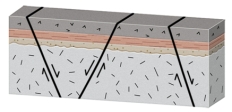
A)the crust will thicken and the region will be uplifted
B)the crust will thin and the region will be uplifted
C)the fault blocks will rotate in the same direction,like books sliding on a shelf
D)the blocks will be uplifted or downdropped with only minor rotation
A)the crust will thicken and the region will be uplifted
B)the crust will thin and the region will be uplifted
C)the fault blocks will rotate in the same direction,like books sliding on a shelf
D)the blocks will be uplifted or downdropped with only minor rotation
Question
Question
Question
Question
Question
Question
A continental shelf along a passive margin is below sea level because: 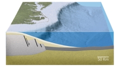
A)it is underlain by oceanic crust
B)it was a mountain that was eroded away
C)the crust has been thinned by normal faulting
D)the weight of the continental crust pushes it down
A)it is underlain by oceanic crust
B)it was a mountain that was eroded away
C)the crust has been thinned by normal faulting
D)the weight of the continental crust pushes it down
Question
Question
Question
Which of these numbered features is an accretionary prism? 
A)1
B)2
C)3
D)4
E)5
A)1
B)2
C)3
D)4
E)5
Question
Question
Question
Which of these numbered features is a foreland basin? 
A)1
B)2
C)3
D)4
E)5
A)1
B)2
C)3
D)4
E)5
Question
Question
Which of the following happened to form the features in this region? 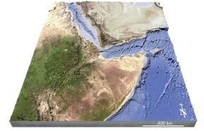
A)formation of a continental hot spot
B)continental rifting
C)seafloor spreading
D)volcanism that produced new land
E)all of these
A)formation of a continental hot spot
B)continental rifting
C)seafloor spreading
D)volcanism that produced new land
E)all of these
Question
Which numbered area on this geologic map of North America consists of recently added tectonic terranes? 
A)1,southern Alaska
B)2,continental platform of west-central Canada
C)3,continental shield of eastern Canada
D)4,coastal plain along the Gulf Coast of the U.S.
A)1,southern Alaska
B)2,continental platform of west-central Canada
C)3,continental shield of eastern Canada
D)4,coastal plain along the Gulf Coast of the U.S.
Question
Which feature is interpreted to be in the Yellowstone region (1)? 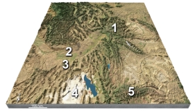
A)a continental collision
B)a meteorite impact
C)a continental hot spot
D)a foreland basin
A)a continental collision
B)a meteorite impact
C)a continental hot spot
D)a foreland basin
Question
On this map of the area around Yellowstone,which feature is interpreted to record the position of the hot spot over time? 
A)2,the Snake River Plain
B)3,the Uinta Mountains
C)4,the Bonneville Salt Flats
D)all of these
A)2,the Snake River Plain
B)3,the Uinta Mountains
C)4,the Bonneville Salt Flats
D)all of these
Question
Which feature on this figure formed entirely before joining of these two terranes? 
A)sediment with fossils (F)
B)the overlapping sedimentary unit (O)
C)the pluton (P)
D)the shear zone and fault (S)
E)none of these
A)sediment with fossils (F)
B)the overlapping sedimentary unit (O)
C)the pluton (P)
D)the shear zone and fault (S)
E)none of these
Question
Question
Question
Question
The basin shown in this figure was actively subsiding during the formation of unit: 
A)A
B)B
C)C
D)D
E)E
A)A
B)B
C)C
D)D
E)E
Question
Question
Which numbered site is likely to have exposure of crystalline rocks? 
A)1,the continental shield
B)2,the continental platform
C)3,a basin in the continent
D)4,a continental shelf
E)5,a deep sediment-filled basin next to the continent
A)1,the continental shield
B)2,the continental platform
C)3,a basin in the continent
D)4,a continental shelf
E)5,a deep sediment-filled basin next to the continent
Question
Which numbered site is likely to have a thin sequence of sediments over crystalline rocks of the basement? 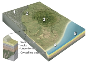
A)1,the continental shield
B)2,the continental platform
C)3,a basin in the continent
D)4,a continental shelf
E)5,a deep sediment-filled basin next to the continent
A)1,the continental shield
B)2,the continental platform
C)3,a basin in the continent
D)4,a continental shelf
E)5,a deep sediment-filled basin next to the continent
Question
Question
Which feature on this figure formed during the time when these two terranes joined? 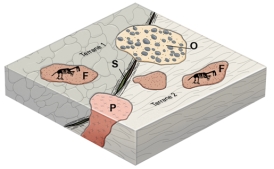
A)sediment with fossils (F)
B)the overlapping sedimentary unit (O)
C)the pluton (P)
D)the shear zone and fault (S)
E)all of these
A)sediment with fossils (F)
B)the overlapping sedimentary unit (O)
C)the pluton (P)
D)the shear zone and fault (S)
E)all of these
Question
Which feature on this figure formed after the two terranes were already joined? 
A)sediment with fossils (F)
B)the overlapping sedimentary unit (O)
C)the pluton (P)
D)all of these
A)sediment with fossils (F)
B)the overlapping sedimentary unit (O)
C)the pluton (P)
D)all of these
Question
Question
Question
Question
What is the timing of the basin shown in this figure? 
A)it was still forming during the eruption of volcanic unit A
B)it began forming during deposition of unit E
C)it began forming during deposition of unit D
D)both a and b
E)none of these
A)it was still forming during the eruption of volcanic unit A
B)it began forming during deposition of unit E
C)it began forming during deposition of unit D
D)both a and b
E)none of these
Question
Question
Question
Question
What geologic setting is expressed by the formation of the Sierra Nevada and adjacent features? 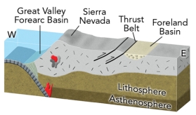
A)a continental collision east of (to the right of)the Sierra Nevada
B)an ocean-continent convergent zone
C)a continental rifting event east of (to the right of)the Sierra Nevada
D)continental rifting west (to the left of)of the Sierra Nevada
A)a continental collision east of (to the right of)the Sierra Nevada
B)an ocean-continent convergent zone
C)a continental rifting event east of (to the right of)the Sierra Nevada
D)continental rifting west (to the left of)of the Sierra Nevada
Question
Question
What geologic events are expressed in this cross section of the western U.S.in late Paleozoic - early Mesozoic time? 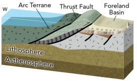
A)an old episode of continental rifting that lead to a passive margin
B)collision of an island arc with western North America
C)oceanic crust and sediment that was thrust onto North America
D)a basin formed by the weight of thrust sheets
E)all of these
A)an old episode of continental rifting that lead to a passive margin
B)collision of an island arc with western North America
C)oceanic crust and sediment that was thrust onto North America
D)a basin formed by the weight of thrust sheets
E)all of these
Question
Question
Question
What geologic events are expressed in this cross section showing the interpreted geologic setting of the eastern U.S.during middle Paleozoic time? 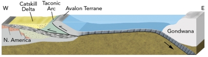
A)the collision of an island arc with eastern North America
B)the collision of a microcontinent with eastern North America
C)a foreland basin
D)a future continental collision
E)all of these
A)the collision of an island arc with eastern North America
B)the collision of a microcontinent with eastern North America
C)a foreland basin
D)a future continental collision
E)all of these
Question
Question
Question
Question
Question
Question
Question
Question
Question
Question
Which numbered area on this geologic map of North America would contain the oldest rocks exposed at the surface? 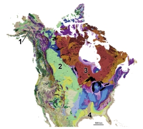
A)1,southern Alaska
B)2,continental platform of west-central Canada
C)3,continental shield of eastern Canada
D)4,coastal plain along the Gulf Coast of the U.S.
A)1,southern Alaska
B)2,continental platform of west-central Canada
C)3,continental shield of eastern Canada
D)4,coastal plain along the Gulf Coast of the U.S.
Question
Question

Unlock Deck
Sign up to unlock the cards in this deck!
Unlock Deck
Unlock Deck
1/91
Play
Full screen (f)
Deck 11: Mountains, basins, and Continents
1
If you had this type of deformation of a region,it would:
A)thicken the crust and cause subsidence
B)thicken the crust and cause uplift
C)thin the crust and cause subsidence
D)thin the crust and cause uplift
E)none of these
A)thicken the crust and cause subsidence
B)thicken the crust and cause uplift
C)thin the crust and cause subsidence
D)thin the crust and cause uplift
E)none of these
C
2
The Himalaya are:
A)the highest mountain range in the world and contain Earth's highest peak
B)near the Colorado Plateau,one of the world's largest plateaus
C)underlain by abnormally thin lithosphere
D)an ancient mountain range with most uplift occurring 200 million years ago
E)all of these
A)the highest mountain range in the world and contain Earth's highest peak
B)near the Colorado Plateau,one of the world's largest plateaus
C)underlain by abnormally thin lithosphere
D)an ancient mountain range with most uplift occurring 200 million years ago
E)all of these
A
3
In which of the following environments is the lithosphere likely to be thinnest?
A)beneath a mid-ocean ridge
B)beneath a typical part of the abyssal plain
C)a tectonically active continental margin
D)the interior of a continent away from plate boundaries
A)beneath a mid-ocean ridge
B)beneath a typical part of the abyssal plain
C)a tectonically active continental margin
D)the interior of a continent away from plate boundaries
A
4
Which of these regions is high because of mantle upwelling near a continental rift?
A)1,Andes of South America
B)2,East Africa
C)3,Tibet
D)none of these
A)1,Andes of South America
B)2,East Africa
C)3,Tibet
D)none of these
Unlock Deck
Unlock for access to all 91 flashcards in this deck.
Unlock Deck
k this deck
5
Regional elevation can be decreased by:
A)normal faulting that thins the crust
B)erosion
C)cooling of the crust
D)all of these
A)normal faulting that thins the crust
B)erosion
C)cooling of the crust
D)all of these
Unlock Deck
Unlock for access to all 91 flashcards in this deck.
Unlock Deck
k this deck
6
Regional elevation can be increased by:
A)thinning the crust
B)normal faulting
C)eroding material from the top
D)heating the crust and mantle
A)thinning the crust
B)normal faulting
C)eroding material from the top
D)heating the crust and mantle
Unlock Deck
Unlock for access to all 91 flashcards in this deck.
Unlock Deck
k this deck
7
What could cause a region to be higher in elevation than an average part of a continent?
A)thinner continental crust
B)less dense continental crust
C)cooler continental crust
D)crust that has been horizontally stretched
A)thinner continental crust
B)less dense continental crust
C)cooler continental crust
D)crust that has been horizontally stretched
Unlock Deck
Unlock for access to all 91 flashcards in this deck.
Unlock Deck
k this deck
8
Regional elevation can be increased by:
A)thrust faulting that thickens the crust
B)constructing huge volcanic fields
C)adding a significant amount of magma at depth
D)heating a region's crust and mantle
E)all of these
A)thrust faulting that thickens the crust
B)constructing huge volcanic fields
C)adding a significant amount of magma at depth
D)heating a region's crust and mantle
E)all of these
Unlock Deck
Unlock for access to all 91 flashcards in this deck.
Unlock Deck
k this deck
9
If you had this type of deformation of a region,it would:
A)thicken the crust and cause subsidence
B)thicken the crust and cause uplift
C)thin the crust and cause subsidence
D)thin the crust and cause uplift
E)none of these
A)thicken the crust and cause subsidence
B)thicken the crust and cause uplift
C)thin the crust and cause subsidence
D)thin the crust and cause uplift
E)none of these
Unlock Deck
Unlock for access to all 91 flashcards in this deck.
Unlock Deck
k this deck
10
If you had this type of deformation of a region,it would:
A)thicken the crust and cause subsidence
B)thicken the crust and cause uplift
C)thin the crust and cause subsidence
D)thin the crust and cause uplift
E)none of these
A)thicken the crust and cause subsidence
B)thicken the crust and cause uplift
C)thin the crust and cause subsidence
D)thin the crust and cause uplift
E)none of these
Unlock Deck
Unlock for access to all 91 flashcards in this deck.
Unlock Deck
k this deck
11
Regional elevations on land are primarily controlled by:
A)the temperature of the crust
B)whether the crust is old or was formed more recently
C)whether the area is over a hot spot
D)the thickness of continental crust
A)the temperature of the crust
B)whether the crust is old or was formed more recently
C)whether the area is over a hot spot
D)the thickness of continental crust
Unlock Deck
Unlock for access to all 91 flashcards in this deck.
Unlock Deck
k this deck
12
The principle of isostasy was discovered by observing:
A)wooden blocks floating in a tank
B)icebergs of various sizes floating in the ocean
C)discrepancies in measurements made by surveyors in India
A)wooden blocks floating in a tank
B)icebergs of various sizes floating in the ocean
C)discrepancies in measurements made by surveyors in India
Unlock Deck
Unlock for access to all 91 flashcards in this deck.
Unlock Deck
k this deck
13
Which of these regions is high because of a continental collision?
A)1,Andes of South America
B)2,East Africa Rift
C)3,Tibet
D)none of these
A)1,Andes of South America
B)2,East Africa Rift
C)3,Tibet
D)none of these
Unlock Deck
Unlock for access to all 91 flashcards in this deck.
Unlock Deck
k this deck
14
Which of the following regions below would you predict to have the thickest continental crust?
A)the West Coast because it is close to the plate boundary
B)the Colorado Rockies and adjacent Great Plains
C)the area with thick sediments around the Mississippi River
D)the Appalachian Mountains,the dominant range in the eastern U.S.
E)the East Coast because it is a passive margin
A)the West Coast because it is close to the plate boundary
B)the Colorado Rockies and adjacent Great Plains
C)the area with thick sediments around the Mississippi River
D)the Appalachian Mountains,the dominant range in the eastern U.S.
E)the East Coast because it is a passive margin
Unlock Deck
Unlock for access to all 91 flashcards in this deck.
Unlock Deck
k this deck
15
If you had this type of deformation of a region,it would:
A)thicken the crust and cause subsidence
B)thicken the crust and cause uplift
C)thin the crust and cause subsidence
D)thin the crust and cause uplift
E)none of these
A)thicken the crust and cause subsidence
B)thicken the crust and cause uplift
C)thin the crust and cause subsidence
D)thin the crust and cause uplift
E)none of these
Unlock Deck
Unlock for access to all 91 flashcards in this deck.
Unlock Deck
k this deck
16
Which of the following will be accompanied by a decrease in elevation?
A)gaining crustal material,such as by deposition
B)moving from oceanic crust to continental crust
C)compressing the crust from the sides
D)increasing the thickness of the lithosphere
A)gaining crustal material,such as by deposition
B)moving from oceanic crust to continental crust
C)compressing the crust from the sides
D)increasing the thickness of the lithosphere
Unlock Deck
Unlock for access to all 91 flashcards in this deck.
Unlock Deck
k this deck
17
How can we tell that the Himalaya has been uplifted?
A)uplift can be measured with a global positioning system (GPS)
B)deep rocks are exposed at the surface and yield young isotopic ages
C)the top of Mount Everest contains a limestone with marine fossils
D)all of these
A)uplift can be measured with a global positioning system (GPS)
B)deep rocks are exposed at the surface and yield young isotopic ages
C)the top of Mount Everest contains a limestone with marine fossils
D)all of these
Unlock Deck
Unlock for access to all 91 flashcards in this deck.
Unlock Deck
k this deck
18
If you erode material off of a region,it would:
A)thicken the crust
B)thin the crust
C)cause the region to increase in elevation
D)none of these
A)thicken the crust
B)thin the crust
C)cause the region to increase in elevation
D)none of these
Unlock Deck
Unlock for access to all 91 flashcards in this deck.
Unlock Deck
k this deck
19
Which of the following is NOT a setting in which regional mountain belts form?
A)continental collision
B)subduction zone
C)upwelling of the mantle
D)passive margin
E)the collision of India with Asia
A)continental collision
B)subduction zone
C)upwelling of the mantle
D)passive margin
E)the collision of India with Asia
Unlock Deck
Unlock for access to all 91 flashcards in this deck.
Unlock Deck
k this deck
20
Which of these regions is high because of subduction of an oceanic plate?
A)1,Andes of South America
B)2,East Africa
C)3,Tibet
D)none of these
A)1,Andes of South America
B)2,East Africa
C)3,Tibet
D)none of these
Unlock Deck
Unlock for access to all 91 flashcards in this deck.
Unlock Deck
k this deck
21
What type of basin is shown in this figure?
A)passive margin
B)normal-fault basin
C)foreland basin
D)basin along a strike-slip fault
A)passive margin
B)normal-fault basin
C)foreland basin
D)basin along a strike-slip fault
Unlock Deck
Unlock for access to all 91 flashcards in this deck.
Unlock Deck
k this deck
22
What will happen during movement on these normal faults?
A)the crust will thicken and the region will be uplifted
B)the crust will thin and the region will be uplifted
C)the fault blocks will rotate in the same direction,like books sliding on a shelf
D)the blocks will be uplifted or downdropped with only minor rotation
A)the crust will thicken and the region will be uplifted
B)the crust will thin and the region will be uplifted
C)the fault blocks will rotate in the same direction,like books sliding on a shelf
D)the blocks will be uplifted or downdropped with only minor rotation
Unlock Deck
Unlock for access to all 91 flashcards in this deck.
Unlock Deck
k this deck
23
In the region shown in this figure,what is the most likely cause for a basin between the arc and continent?
A)it is a foreland basin
B)it is an accretionary prism
C)it formed by back-arc rifting and spreading
D)it formed by strike-slip motion during a continental collision
A)it is a foreland basin
B)it is an accretionary prism
C)it formed by back-arc rifting and spreading
D)it formed by strike-slip motion during a continental collision
Unlock Deck
Unlock for access to all 91 flashcards in this deck.
Unlock Deck
k this deck
24
Which of these numbered features is a fold and thrust belt?
A)1
B)2
C)3
D)4
E)5
A)1
B)2
C)3
D)4
E)5
Unlock Deck
Unlock for access to all 91 flashcards in this deck.
Unlock Deck
k this deck
25
Which of the following occurs when mountain belts are eroded?
A)erosion is accompanied by isostatic rebound
B)the continental crust becomes thinner
C)deep metamorphic and plutonic rocks can be uplifted to the surface
D)all of these
A)erosion is accompanied by isostatic rebound
B)the continental crust becomes thinner
C)deep metamorphic and plutonic rocks can be uplifted to the surface
D)all of these
Unlock Deck
Unlock for access to all 91 flashcards in this deck.
Unlock Deck
k this deck
26
Why is there a basin associated with some thrust faults?
A)thrust faults thin the crust and cause subsidence
B)thrust faults form passive margins
C)thrust sheets depress the crust in front of the thrust
D)thrust sheets form a continent rift
A)thrust faults thin the crust and cause subsidence
B)thrust faults form passive margins
C)thrust sheets depress the crust in front of the thrust
D)thrust sheets form a continent rift
Unlock Deck
Unlock for access to all 91 flashcards in this deck.
Unlock Deck
k this deck
27
What will happen during movement on these normal faults?
A)the crust will thicken and the region will be uplifted
B)the crust will thin and the region will be uplifted
C)the fault blocks will rotate in the same direction,like books sliding on a shelf
D)the blocks will be uplifted or downdropped with only minor rotation
A)the crust will thicken and the region will be uplifted
B)the crust will thin and the region will be uplifted
C)the fault blocks will rotate in the same direction,like books sliding on a shelf
D)the blocks will be uplifted or downdropped with only minor rotation
Unlock Deck
Unlock for access to all 91 flashcards in this deck.
Unlock Deck
k this deck
28
Which of the following is NOT a way in which local mountains can be built?
A)prolonged volcanism in composite volcanoes
B)thrust faulting
C)normal faulting
D)folding
E)all of these are ways to make local mountains
A)prolonged volcanism in composite volcanoes
B)thrust faulting
C)normal faulting
D)folding
E)all of these are ways to make local mountains
Unlock Deck
Unlock for access to all 91 flashcards in this deck.
Unlock Deck
k this deck
29
Which of the following correctly matches the tectonic setting of a mountain belt with an example?
A)subduction zone-East Africa
B)continental collision-Andes Mountains
C)mantle upwelling-Tibet
D)all of these
E)none of these
A)subduction zone-East Africa
B)continental collision-Andes Mountains
C)mantle upwelling-Tibet
D)all of these
E)none of these
Unlock Deck
Unlock for access to all 91 flashcards in this deck.
Unlock Deck
k this deck
30
Which of the following would cause uplift along an ocean-continent convergent margin?
A)thinning of the lithosphere above the subduction zone
B)addition of magmas into the crust from the subduction zone
C)formation of a fold and thrust belt
D)all of these
A)thinning of the lithosphere above the subduction zone
B)addition of magmas into the crust from the subduction zone
C)formation of a fold and thrust belt
D)all of these
Unlock Deck
Unlock for access to all 91 flashcards in this deck.
Unlock Deck
k this deck
31
In what sites can extension occur near a subduction zone?
A)in front of the arc
B)within the arc
C)behind the arc
D)all of these
E)none of these
A)in front of the arc
B)within the arc
C)behind the arc
D)all of these
E)none of these
Unlock Deck
Unlock for access to all 91 flashcards in this deck.
Unlock Deck
k this deck
32
What caused the site of the Catskill Delta in New York to become a basin?
A)rifting of the continent during the breakup of Pangaea
B)formation of a passive margin
C)a foreland basin formed by the weight of thrust sheets
D)down flexing of an oceanic plate during the start of subduction
A)rifting of the continent during the breakup of Pangaea
B)formation of a passive margin
C)a foreland basin formed by the weight of thrust sheets
D)down flexing of an oceanic plate during the start of subduction
Unlock Deck
Unlock for access to all 91 flashcards in this deck.
Unlock Deck
k this deck
33
A continental shelf along a passive margin is below sea level because:
A)it is underlain by oceanic crust
B)it was a mountain that was eroded away
C)the crust has been thinned by normal faulting
D)the weight of the continental crust pushes it down
A)it is underlain by oceanic crust
B)it was a mountain that was eroded away
C)the crust has been thinned by normal faulting
D)the weight of the continental crust pushes it down
Unlock Deck
Unlock for access to all 91 flashcards in this deck.
Unlock Deck
k this deck
34
What happens during movement along rotating fault blocks?
A)The corner of a block that is rotated down becomes a basin.
B)The layers within the blocks rotate,but the blocks themselves do not.
C)The layers and blocks rotate,but the faults do not rotate.
D)The crust is thickened by the compression.
E)None of these.
A)The corner of a block that is rotated down becomes a basin.
B)The layers within the blocks rotate,but the blocks themselves do not.
C)The layers and blocks rotate,but the faults do not rotate.
D)The crust is thickened by the compression.
E)None of these.
Unlock Deck
Unlock for access to all 91 flashcards in this deck.
Unlock Deck
k this deck
35
Which of the following processes forms basins in an ocean-continent convergent boundary?
A)flexing and bending of the continental plate as it goes down into the subduction zone
B)flexing of the continent by weight of the thrust sheets
C)thinning of the lithosphere above the subduction zone
D)thickening of the crust by magmas from the subduction zone
A)flexing and bending of the continental plate as it goes down into the subduction zone
B)flexing of the continent by weight of the thrust sheets
C)thinning of the lithosphere above the subduction zone
D)thickening of the crust by magmas from the subduction zone
Unlock Deck
Unlock for access to all 91 flashcards in this deck.
Unlock Deck
k this deck
36
Which of these numbered features is an accretionary prism?
A)1
B)2
C)3
D)4
E)5
A)1
B)2
C)3
D)4
E)5
Unlock Deck
Unlock for access to all 91 flashcards in this deck.
Unlock Deck
k this deck
37
Which of the following is NOT a tectonic setting in which a basin can form?
A)passive margin
B)in front of a fold and thrust belt
C)along a strike-slip fault
D)at high elevations
E)basins can form in all these settings
A)passive margin
B)in front of a fold and thrust belt
C)along a strike-slip fault
D)at high elevations
E)basins can form in all these settings
Unlock Deck
Unlock for access to all 91 flashcards in this deck.
Unlock Deck
k this deck
38
Which part of the United States has present-day basins or basins preserved in its older rocks?
A)Basin and Range province of the western U.S.
B)Gulf Coast region of the southern U.S.
C)Appalachian Mountains
D)center of the continent,such as Michigan
E)all of these
A)Basin and Range province of the western U.S.
B)Gulf Coast region of the southern U.S.
C)Appalachian Mountains
D)center of the continent,such as Michigan
E)all of these
Unlock Deck
Unlock for access to all 91 flashcards in this deck.
Unlock Deck
k this deck
39
Which of these numbered features is a foreland basin?
A)1
B)2
C)3
D)4
E)5
A)1
B)2
C)3
D)4
E)5
Unlock Deck
Unlock for access to all 91 flashcards in this deck.
Unlock Deck
k this deck
40
What is the main cause of uplift during a continental collision?
A)down flexing of one continent in front of thrust belts
B)addition of magmas from the subduction zone
C)an almost doubling of the thickness of continental crust
D)thinning of the lithosphere
A)down flexing of one continent in front of thrust belts
B)addition of magmas from the subduction zone
C)an almost doubling of the thickness of continental crust
D)thinning of the lithosphere
Unlock Deck
Unlock for access to all 91 flashcards in this deck.
Unlock Deck
k this deck
41
Which of the following happened to form the features in this region?
A)formation of a continental hot spot
B)continental rifting
C)seafloor spreading
D)volcanism that produced new land
E)all of these
A)formation of a continental hot spot
B)continental rifting
C)seafloor spreading
D)volcanism that produced new land
E)all of these
Unlock Deck
Unlock for access to all 91 flashcards in this deck.
Unlock Deck
k this deck
42
Which numbered area on this geologic map of North America consists of recently added tectonic terranes?
A)1,southern Alaska
B)2,continental platform of west-central Canada
C)3,continental shield of eastern Canada
D)4,coastal plain along the Gulf Coast of the U.S.
A)1,southern Alaska
B)2,continental platform of west-central Canada
C)3,continental shield of eastern Canada
D)4,coastal plain along the Gulf Coast of the U.S.
Unlock Deck
Unlock for access to all 91 flashcards in this deck.
Unlock Deck
k this deck
43
Which feature is interpreted to be in the Yellowstone region (1)?
A)a continental collision
B)a meteorite impact
C)a continental hot spot
D)a foreland basin
A)a continental collision
B)a meteorite impact
C)a continental hot spot
D)a foreland basin
Unlock Deck
Unlock for access to all 91 flashcards in this deck.
Unlock Deck
k this deck
44
On this map of the area around Yellowstone,which feature is interpreted to record the position of the hot spot over time?
A)2,the Snake River Plain
B)3,the Uinta Mountains
C)4,the Bonneville Salt Flats
D)all of these
A)2,the Snake River Plain
B)3,the Uinta Mountains
C)4,the Bonneville Salt Flats
D)all of these
Unlock Deck
Unlock for access to all 91 flashcards in this deck.
Unlock Deck
k this deck
45
Which feature on this figure formed entirely before joining of these two terranes?
A)sediment with fossils (F)
B)the overlapping sedimentary unit (O)
C)the pluton (P)
D)the shear zone and fault (S)
E)none of these
A)sediment with fossils (F)
B)the overlapping sedimentary unit (O)
C)the pluton (P)
D)the shear zone and fault (S)
E)none of these
Unlock Deck
Unlock for access to all 91 flashcards in this deck.
Unlock Deck
k this deck
46
How did the Ural Mountains within the middle of the Eurasian plate form?
A)stresses from a distant plate boundary reactivated ancient faults
B)the continent is beginning to break apart along a line of hot spots
C)the area is presently a plate boundary
D)two continents collided,trapping the mountain within the new,larger continent
A)stresses from a distant plate boundary reactivated ancient faults
B)the continent is beginning to break apart along a line of hot spots
C)the area is presently a plate boundary
D)two continents collided,trapping the mountain within the new,larger continent
Unlock Deck
Unlock for access to all 91 flashcards in this deck.
Unlock Deck
k this deck
47
What can occur during the evolution of a hot spot?
A)an initial period of subsidence as magmas rise from the mantle
B)formation of a fold and thrust belt
C)formation of rifts that radiate out from the hot spot
D)thickening of the crust beneath a passive margin
E)none of these
A)an initial period of subsidence as magmas rise from the mantle
B)formation of a fold and thrust belt
C)formation of rifts that radiate out from the hot spot
D)thickening of the crust beneath a passive margin
E)none of these
Unlock Deck
Unlock for access to all 91 flashcards in this deck.
Unlock Deck
k this deck
48
Which of the following is NOT interpreted to be related to a continental hot spot?
A)Afar region of east Africa
B)high elevations of Tibet
C)Yellowstone
D)Snake River Plain of Idaho
E)all of these are related to a continental hot spot
A)Afar region of east Africa
B)high elevations of Tibet
C)Yellowstone
D)Snake River Plain of Idaho
E)all of these are related to a continental hot spot
Unlock Deck
Unlock for access to all 91 flashcards in this deck.
Unlock Deck
k this deck
49
The basin shown in this figure was actively subsiding during the formation of unit:
A)A
B)B
C)C
D)D
E)E
A)A
B)B
C)C
D)D
E)E
Unlock Deck
Unlock for access to all 91 flashcards in this deck.
Unlock Deck
k this deck
50
Which of the following is a valid description of features within continental interiors?
A)The central region of a continent is called a shield and is a broad,basaltic volcano with gentle slopes.
B)The continental platform has nearly horizontal sedimentary rocks deposited on crystalline basement.
C)The oldest exposed rocks in a continent are usually along the coastline.
D)Broad domes and basins in continental interiors have nearly vertical beds around their flanks.
E)All of these.
Unlock Deck
Unlock for access to all 91 flashcards in this deck.
Unlock Deck
k this deck
51
Which numbered site is likely to have exposure of crystalline rocks?
A)1,the continental shield
B)2,the continental platform
C)3,a basin in the continent
D)4,a continental shelf
E)5,a deep sediment-filled basin next to the continent
A)1,the continental shield
B)2,the continental platform
C)3,a basin in the continent
D)4,a continental shelf
E)5,a deep sediment-filled basin next to the continent
Unlock Deck
Unlock for access to all 91 flashcards in this deck.
Unlock Deck
k this deck
52
Which numbered site is likely to have a thin sequence of sediments over crystalline rocks of the basement?
A)1,the continental shield
B)2,the continental platform
C)3,a basin in the continent
D)4,a continental shelf
E)5,a deep sediment-filled basin next to the continent
A)1,the continental shield
B)2,the continental platform
C)3,a basin in the continent
D)4,a continental shelf
E)5,a deep sediment-filled basin next to the continent
Unlock Deck
Unlock for access to all 91 flashcards in this deck.
Unlock Deck
k this deck
53
What can a continental hot spot lead to?
A)formation of a curved continental outline along two rifts
B)localization of a river and delta along the failed arm of the rift
C)a thick accumulation of basalts and other volcanic rocks
D)a region that is high in elevation relative to adjacent parts of the continent
E)all of these
A)formation of a curved continental outline along two rifts
B)localization of a river and delta along the failed arm of the rift
C)a thick accumulation of basalts and other volcanic rocks
D)a region that is high in elevation relative to adjacent parts of the continent
E)all of these
Unlock Deck
Unlock for access to all 91 flashcards in this deck.
Unlock Deck
k this deck
54
Which feature on this figure formed during the time when these two terranes joined?
A)sediment with fossils (F)
B)the overlapping sedimentary unit (O)
C)the pluton (P)
D)the shear zone and fault (S)
E)all of these
A)sediment with fossils (F)
B)the overlapping sedimentary unit (O)
C)the pluton (P)
D)the shear zone and fault (S)
E)all of these
Unlock Deck
Unlock for access to all 91 flashcards in this deck.
Unlock Deck
k this deck
55
Which feature on this figure formed after the two terranes were already joined?
A)sediment with fossils (F)
B)the overlapping sedimentary unit (O)
C)the pluton (P)
D)all of these
A)sediment with fossils (F)
B)the overlapping sedimentary unit (O)
C)the pluton (P)
D)all of these
Unlock Deck
Unlock for access to all 91 flashcards in this deck.
Unlock Deck
k this deck
56
Which of the following does NOT indicate that two terranes were already in contact by a certain time?
A)a sedimentary or volcanic unit of that age overlaps their mutual boundary
B)an intrusion invades both terranes or crosscuts their boundary
C)rock on both side shared the same deformation or metamorphic event
D)the two terranes have fossils of the same age that originated in different environments
A)a sedimentary or volcanic unit of that age overlaps their mutual boundary
B)an intrusion invades both terranes or crosscuts their boundary
C)rock on both side shared the same deformation or metamorphic event
D)the two terranes have fossils of the same age that originated in different environments
Unlock Deck
Unlock for access to all 91 flashcards in this deck.
Unlock Deck
k this deck
57
Which of the following is a characteristic of a terrane?
A)The boundaries of a terrane are generally major faults or shear zones.
B)A terrane has the same sequence of rocks as adjacent areas.
C)To be a terrane,the rocks must form in a deep marine environment.
D)The layers and fossils in a terrane can be matched with those in adjacent areas.
E)None of these.
Unlock Deck
Unlock for access to all 91 flashcards in this deck.
Unlock Deck
k this deck
58
Which of the following is NOT a common setting in which a terrane originally forms?
A)oceanic plateau
B)island arc
C)oceanic crust
D)linear island chain
E)all of these are common settings for a terrane
A)oceanic plateau
B)island arc
C)oceanic crust
D)linear island chain
E)all of these are common settings for a terrane
Unlock Deck
Unlock for access to all 91 flashcards in this deck.
Unlock Deck
k this deck
59
What is the timing of the basin shown in this figure?
A)it was still forming during the eruption of volcanic unit A
B)it began forming during deposition of unit E
C)it began forming during deposition of unit D
D)both a and b
E)none of these
A)it was still forming during the eruption of volcanic unit A
B)it began forming during deposition of unit E
C)it began forming during deposition of unit D
D)both a and b
E)none of these
Unlock Deck
Unlock for access to all 91 flashcards in this deck.
Unlock Deck
k this deck
60
What regional effects influence continental interiors?
A)rises and falls in sea level related to changes in global climate
B)stresses transmitted from distant plate boundaries and mountain belts
C)preexisting fault that can be activated by stresses,causing faulting and folding
D)all of these
A)rises and falls in sea level related to changes in global climate
B)stresses transmitted from distant plate boundaries and mountain belts
C)preexisting fault that can be activated by stresses,causing faulting and folding
D)all of these
Unlock Deck
Unlock for access to all 91 flashcards in this deck.
Unlock Deck
k this deck
61
In what tectonic setting was the Sierra Nevada formed?
A)melting along a transform fault
B)continental rifting
C)a continental collision
D)subduction beneath the continent
E)all of these
A)melting along a transform fault
B)continental rifting
C)a continental collision
D)subduction beneath the continent
E)all of these
Unlock Deck
Unlock for access to all 91 flashcards in this deck.
Unlock Deck
k this deck
62
What tectonic event in the western U.S.caused magmatism and deformation to move farther into the continent during the late Mesozoic and early Cenozoic Laramide Orogeny?
A)the continent overran a hot spot
B)the continent overran the East Pacific Rise
C)continental extension stretched the continent to twice its original width
D)an oceanic plate subducted at a low angle beneath the continent
A)the continent overran a hot spot
B)the continent overran the East Pacific Rise
C)continental extension stretched the continent to twice its original width
D)an oceanic plate subducted at a low angle beneath the continent
Unlock Deck
Unlock for access to all 91 flashcards in this deck.
Unlock Deck
k this deck
63
What geologic setting is expressed by the formation of the Sierra Nevada and adjacent features?
A)a continental collision east of (to the right of)the Sierra Nevada
B)an ocean-continent convergent zone
C)a continental rifting event east of (to the right of)the Sierra Nevada
D)continental rifting west (to the left of)of the Sierra Nevada
A)a continental collision east of (to the right of)the Sierra Nevada
B)an ocean-continent convergent zone
C)a continental rifting event east of (to the right of)the Sierra Nevada
D)continental rifting west (to the left of)of the Sierra Nevada
Unlock Deck
Unlock for access to all 91 flashcards in this deck.
Unlock Deck
k this deck
64
According to the cross sections in the textbook,which of the following tectonic settings did not happen during the Paleozoic evolution of northern Appalachian Mountains?
A)continental rifting
B)passive margin
C)subduction beneath an offshore island arc
D)continental collision
E)all of these occurred at one time or another
A)continental rifting
B)passive margin
C)subduction beneath an offshore island arc
D)continental collision
E)all of these occurred at one time or another
Unlock Deck
Unlock for access to all 91 flashcards in this deck.
Unlock Deck
k this deck
65
What geologic events are expressed in this cross section of the western U.S.in late Paleozoic - early Mesozoic time?
A)an old episode of continental rifting that lead to a passive margin
B)collision of an island arc with western North America
C)oceanic crust and sediment that was thrust onto North America
D)a basin formed by the weight of thrust sheets
E)all of these
A)an old episode of continental rifting that lead to a passive margin
B)collision of an island arc with western North America
C)oceanic crust and sediment that was thrust onto North America
D)a basin formed by the weight of thrust sheets
E)all of these
Unlock Deck
Unlock for access to all 91 flashcards in this deck.
Unlock Deck
k this deck
66
What events occurred in the western U.S.during middle and late Paleozoic time?
A)collisions with island arcs
B)thrust faults
C)formation of mountains called the Ancestral Rockies
D)all of these
A)collisions with island arcs
B)thrust faults
C)formation of mountains called the Ancestral Rockies
D)all of these
Unlock Deck
Unlock for access to all 91 flashcards in this deck.
Unlock Deck
k this deck
67
Which parts of North America have NOT been added to the continent since the Precambrian?
A)some parts of the Appalachian Mountains
B)rocks along the West Coast
C)Alaska and western Canada
D)Canadian Shield
E)all of these
A)some parts of the Appalachian Mountains
B)rocks along the West Coast
C)Alaska and western Canada
D)Canadian Shield
E)all of these
Unlock Deck
Unlock for access to all 91 flashcards in this deck.
Unlock Deck
k this deck
68
What geologic events are expressed in this cross section showing the interpreted geologic setting of the eastern U.S.during middle Paleozoic time?
A)the collision of an island arc with eastern North America
B)the collision of a microcontinent with eastern North America
C)a foreland basin
D)a future continental collision
E)all of these
A)the collision of an island arc with eastern North America
B)the collision of a microcontinent with eastern North America
C)a foreland basin
D)a future continental collision
E)all of these
Unlock Deck
Unlock for access to all 91 flashcards in this deck.
Unlock Deck
k this deck
69
What was the main tectonic setting of the western U.S.in early Paleozoic time?
A)continental collision
B)transform fault
C)passive margin
D)the interior of a supercontinent
A)continental collision
B)transform fault
C)passive margin
D)the interior of a supercontinent
Unlock Deck
Unlock for access to all 91 flashcards in this deck.
Unlock Deck
k this deck
70
Which of the following is NOT a type of terrane in California?
A)oceanic crust
B)island arcs
C)accretionary prism
D)displaced granitic rocks
E)all of these are present in California
A)oceanic crust
B)island arcs
C)accretionary prism
D)displaced granitic rocks
E)all of these are present in California
Unlock Deck
Unlock for access to all 91 flashcards in this deck.
Unlock Deck
k this deck
71
Where was India located during most of the Mesozoic?
A)the Southern Hemisphere
B)connected with Africa and Antarctic
C)part of the supercontinent of Gondwana
D)all of these
E)none of these
A)the Southern Hemisphere
B)connected with Africa and Antarctic
C)part of the supercontinent of Gondwana
D)all of these
E)none of these
Unlock Deck
Unlock for access to all 91 flashcards in this deck.
Unlock Deck
k this deck
72
Where was North America 150 million years ago?
A)next to Antarctica
B)next to Australia
C)over the south pole
D)closer to Africa and South America
E)none of these
A)next to Antarctica
B)next to Australia
C)over the south pole
D)closer to Africa and South America
E)none of these
Unlock Deck
Unlock for access to all 91 flashcards in this deck.
Unlock Deck
k this deck
73
How many times has rifting occurred along eastern North America since 600 million years ago?
A)once in the Mesozoic
B)once near the start of the Paleozoic
C)twice,once in the Mesozoic and once near the start of the Paleozoic
D)four times
A)once in the Mesozoic
B)once near the start of the Paleozoic
C)twice,once in the Mesozoic and once near the start of the Paleozoic
D)four times
Unlock Deck
Unlock for access to all 91 flashcards in this deck.
Unlock Deck
k this deck
74
What part of North America contains the oldest exposed rocks?
A)the Appalachian Mountains
B)western North America
C)Alaska and western Canada
D)the Canadian Shield
E)the east coast of Canada and nearby parts of the U.S.
A)the Appalachian Mountains
B)western North America
C)Alaska and western Canada
D)the Canadian Shield
E)the east coast of Canada and nearby parts of the U.S.
Unlock Deck
Unlock for access to all 91 flashcards in this deck.
Unlock Deck
k this deck
75
During what time did the western U.S.experience a large amount of crustal extension?
A)middle Paleozoic
B)early Mesozoic
C)late Mesozoic
D)middle and late Cenozoic
A)middle Paleozoic
B)early Mesozoic
C)late Mesozoic
D)middle and late Cenozoic
Unlock Deck
Unlock for access to all 91 flashcards in this deck.
Unlock Deck
k this deck
76
Which of the following is NOT the name of a supercontinent?
A)Gondwana
B)Laurasia
C)Pangaea
D)Rodinia
E)Tethys
A)Gondwana
B)Laurasia
C)Pangaea
D)Rodinia
E)Tethys
Unlock Deck
Unlock for access to all 91 flashcards in this deck.
Unlock Deck
k this deck
77
Which of the following resulted in an orogeny in eastern North America?
A)collision with an island arc
B)collision with a land mass called Avalonia
C)a continental collision
D)all of these
E)a and b only
A)collision with an island arc
B)collision with a land mass called Avalonia
C)a continental collision
D)all of these
E)a and b only
Unlock Deck
Unlock for access to all 91 flashcards in this deck.
Unlock Deck
k this deck
78
Which numbered area on this geologic map of North America would contain the oldest rocks exposed at the surface?
A)1,southern Alaska
B)2,continental platform of west-central Canada
C)3,continental shield of eastern Canada
D)4,coastal plain along the Gulf Coast of the U.S.
A)1,southern Alaska
B)2,continental platform of west-central Canada
C)3,continental shield of eastern Canada
D)4,coastal plain along the Gulf Coast of the U.S.
Unlock Deck
Unlock for access to all 91 flashcards in this deck.
Unlock Deck
k this deck
79
Which of the following is used to match continents or track positions of the continents in the past?
A)reconstructions of seafloor spreading
B)rock types and structures
C)magnetism stored in rocks
D)all of these
E)a and b only
A)reconstructions of seafloor spreading
B)rock types and structures
C)magnetism stored in rocks
D)all of these
E)a and b only
Unlock Deck
Unlock for access to all 91 flashcards in this deck.
Unlock Deck
k this deck
80
What is the main reason why the age of oldest rocks can vary from one part of a continent to another?
A)older rocks are commonly remelted over huge regions
B)older rocks have been uplifted and eroded away
C)large parts of the continent are subducted deep within the mantle
D)parts of the continent have been added by the accretion of tectonic terranes
A)older rocks are commonly remelted over huge regions
B)older rocks have been uplifted and eroded away
C)large parts of the continent are subducted deep within the mantle
D)parts of the continent have been added by the accretion of tectonic terranes
Unlock Deck
Unlock for access to all 91 flashcards in this deck.
Unlock Deck
k this deck
Unlock Deck
Unlock for access to all 91 flashcards in this deck.


