Deck 14: Glaciers and Glacial Landforms
Full screen (f)
Question
Question
The circular-shaped mass of ice shown in the center of the photograph below is a(n) 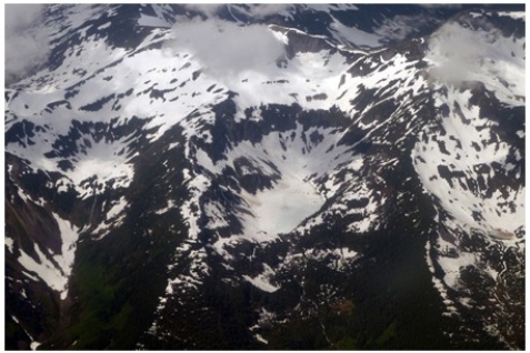
A)cirque glacier.
B)ice sheet.
C)snowfield.
D)ice shelf.
A)cirque glacier.
B)ice sheet.
C)snowfield.
D)ice shelf.
Question
Question
Question
Question
In the map below,the two ice sheets shown are called the 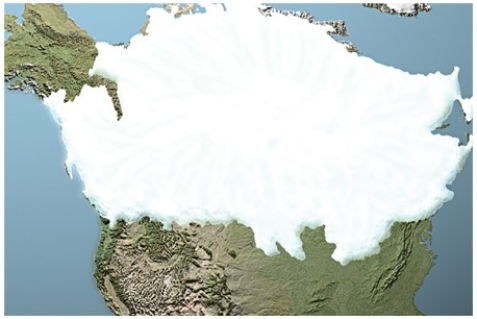
A)Cordilleran in the west and Laurentide in the east.
B)Laurentide in the west and Cordilleran in the east.
C)Yukon in the west and Aftonian in the east.
D)Sangamon in the west and Icelandic in the east.
A)Cordilleran in the west and Laurentide in the east.
B)Laurentide in the west and Cordilleran in the east.
C)Yukon in the west and Aftonian in the east.
D)Sangamon in the west and Icelandic in the east.
Question
What is the origin of curved ridges (R on this figure)in the Great Lakes area? 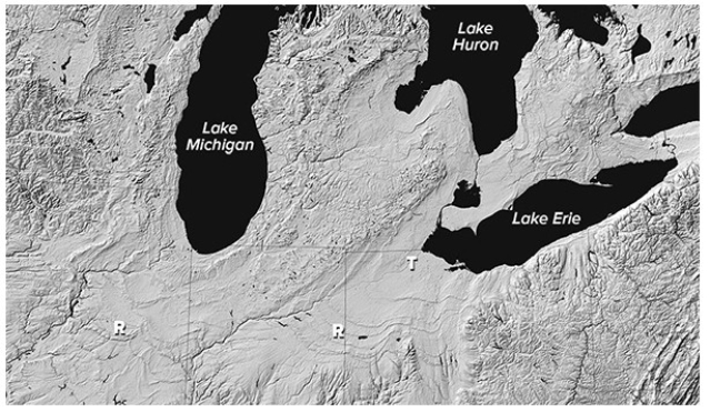
A)Folds produced during a continental collision
B)Paths of ancient rivers
C)Piles of sediment deposited by retreating glaciers
D)Remnants of a meteoroid impact
A)Folds produced during a continental collision
B)Paths of ancient rivers
C)Piles of sediment deposited by retreating glaciers
D)Remnants of a meteoroid impact
Question
What type of glacier is shown below on the gently sloping land near the coastline? 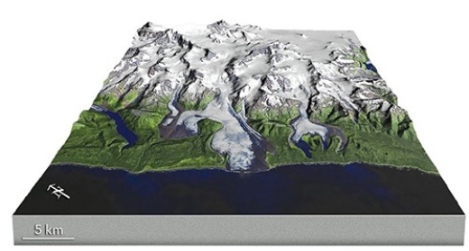
A)Tropical coast glacier
B)Shoreline glacier
C)Piedmont glacier
D)Continental ice sheet
A)Tropical coast glacier
B)Shoreline glacier
C)Piedmont glacier
D)Continental ice sheet
Question
Question
The feature below has angular rocks on the outside and slowly flowing ice on the inside.It is called a(n) 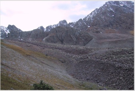
A)ice glacier.
B)nunatak.
C)cirque glacier.
D)rock glacier.
A)ice glacier.
B)nunatak.
C)cirque glacier.
D)rock glacier.
Question
What is the origin of smooth troughs (T on this figure)cutting across the landscape in the Great Lakes area? 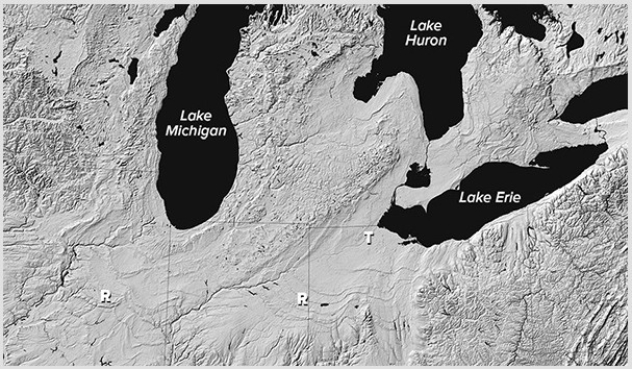
A)The areas were covered by soft marine sediments.
B)A huge flood coming from Iowa flowed toward the Great Lakes.
C)Glaciers carved out the smooth troughs.
D)All of these are correct.
A)The areas were covered by soft marine sediments.
B)A huge flood coming from Iowa flowed toward the Great Lakes.
C)Glaciers carved out the smooth troughs.
D)All of these are correct.
Question
What type of glacier is shown in the center of this image? 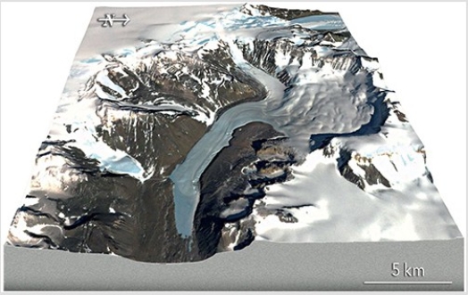
A)Ribbon glacier
B)Valley glacier
C)Low-elevation glacier
D)High-elevation glacier
A)Ribbon glacier
B)Valley glacier
C)Low-elevation glacier
D)High-elevation glacier
Question
Question
Question
Question
Question
Question
The exposed bedrock in the background of the figure below,to the right,formed as 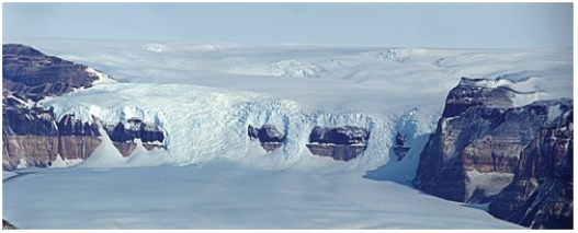
A)isostatic rebound caused the land to extend upward.
B)particularly resistant rock and/or thin ice left the rock above the ice surface.
C)a mantle hot spot melted the glacier in this localized area.
D)local wind-blown deposition concentrated in this area of the glacier.
A)isostatic rebound caused the land to extend upward.
B)particularly resistant rock and/or thin ice left the rock above the ice surface.
C)a mantle hot spot melted the glacier in this localized area.
D)local wind-blown deposition concentrated in this area of the glacier.
Question
Question
Question
What feature will be formed by the sediment carried along the sides of this glacier? 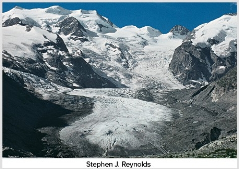
A)Cirque
B)Tarn
C)Arête
D)Lateral moraine
E)None of these are correct.
A)Cirque
B)Tarn
C)Arête
D)Lateral moraine
E)None of these are correct.
Question
In the photograph below,the ice must have flowed 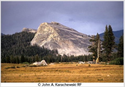
A)from the background into the foreground (i.e.,out of the screen and toward you).
B)from the foreground into the background (i.e.,away from you as you are looking at it).
C)from left to right.
D)from right to left.
A)from the background into the foreground (i.e.,out of the screen and toward you).
B)from the foreground into the background (i.e.,away from you as you are looking at it).
C)from left to right.
D)from right to left.
Question
Question
Question
The primary reason that this feature formed is that 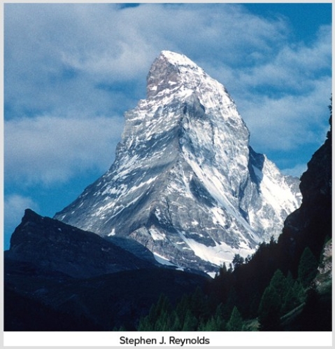
A)abrasion occurred on all sides,without plucking.
B)three or more cirques merged by headward erosion.
C)precipitation at the top of the mountain ran downward very quickly.
D)a series of faults surrounded a very localized area and uplifted it.
A)abrasion occurred on all sides,without plucking.
B)three or more cirques merged by headward erosion.
C)precipitation at the top of the mountain ran downward very quickly.
D)a series of faults surrounded a very localized area and uplifted it.
Question
What carved this U-shaped valley? 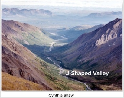
A)A rapidly downcutting river
B)A slowly downcutting river
C)Wind
D)Glacier
A)A rapidly downcutting river
B)A slowly downcutting river
C)Wind
D)Glacier
Question
The main reason that the deposits shown here are sorted and stratified is that the glacier that dropped them was 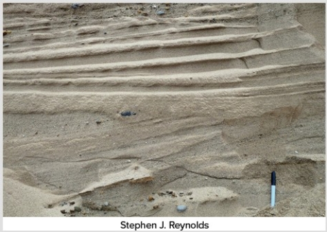
A)moving very slowly.
B)accompanied by running meltwater.
C)moving through very soft,erodible bedrock.
D)moving through very flat terrain.
A)moving very slowly.
B)accompanied by running meltwater.
C)moving through very soft,erodible bedrock.
D)moving through very flat terrain.
Question
Which feature on this diagram is a cirque? 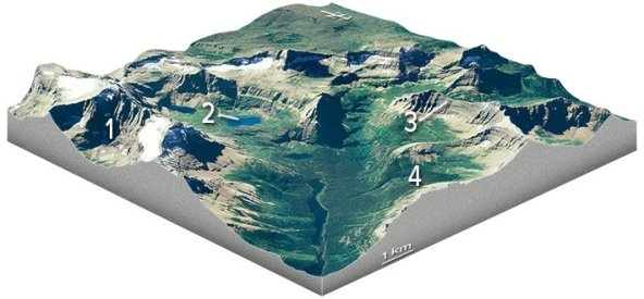
A)1,the circular depression at the head of the valley
B)2,a lake in the upper valley
C)3,a steep ridge
D)4,a valley that is above the level of the main valley
A)1,the circular depression at the head of the valley
B)2,a lake in the upper valley
C)3,a steep ridge
D)4,a valley that is above the level of the main valley
Question
Question
Question
The lakes in the photograph below are all connected by a stream,so they are called 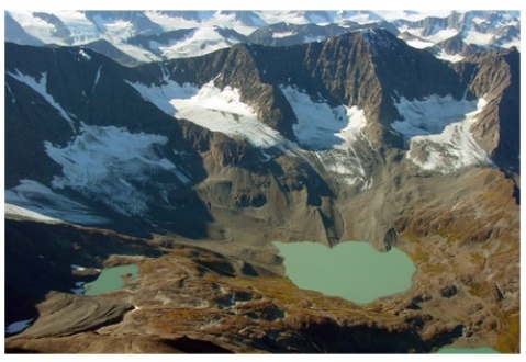
A)cols.
B)kames.
C)paternoster lakes.
D)cirques.
A)cols.
B)kames.
C)paternoster lakes.
D)cirques.
Question
What is this bowl-shaped,glacially carved feature? 
A)Hanging valley
B)Arête
C)Cirque
D)Continental ice sheet
A)Hanging valley
B)Arête
C)Cirque
D)Continental ice sheet
Question
Which feature on this diagram is a hanging valley? 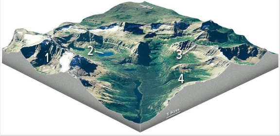
A)1,the circular depression at the head of the valley
B)2,a lake in the upper valley
C)3,a steep ridge
D)4,a valley that is above the level of the main valley
A)1,the circular depression at the head of the valley
B)2,a lake in the upper valley
C)3,a steep ridge
D)4,a valley that is above the level of the main valley
Question
What name best describes the area of the lake in this photograph? 
A)Terminal moraine
B)Equilibrium line
C)Fjord
D)Lateral moraine
E)Drumlin
A)Terminal moraine
B)Equilibrium line
C)Fjord
D)Lateral moraine
E)Drumlin
Question
What are these sharp,glacially carved ridges? 
A)Cirque
B)Arête
C)Hogback
D)Razorback
E)Flatiron
A)Cirque
B)Arête
C)Hogback
D)Razorback
E)Flatiron
Question
The feature in the photograph below is a(n) 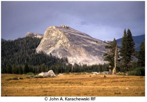
A)drumlin.
B)roche moutonnée.
C)esker.
D)kame.
A)drumlin.
B)roche moutonnée.
C)esker.
D)kame.
Question
Question
Which feature on this diagram is an arête? 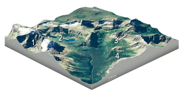
A)1,the circular depression at the head of the valley
B)2,a lake in the upper valley
C)3,a steep ridge
D)4,a valley that is above the level of the main valley
A)1,the circular depression at the head of the valley
B)2,a lake in the upper valley
C)3,a steep ridge
D)4,a valley that is above the level of the main valley
Question
The feature in the photograph below was formed by 
A)plucking.
B)abrasion.
C)plucking on the left and abrasion on the right.
D)abrasion on the left and plucking on the right.
A)plucking.
B)abrasion.
C)plucking on the left and abrasion on the right.
D)abrasion on the left and plucking on the right.
Question
Which feature on this diagram is a tarn? 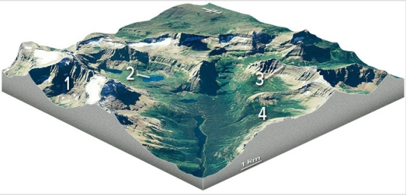
A)1,the circular depression at the head of the valley
B)2,a lake in the upper valley
C)3,a steep ridge
D)4,a valley that is above the level of the main valley
A)1,the circular depression at the head of the valley
B)2,a lake in the upper valley
C)3,a steep ridge
D)4,a valley that is above the level of the main valley
Question
What is the feature numbered 2 in the upper left part of this figure? 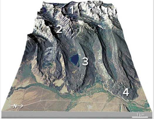
A)Cirque
B)U-shaped valley
C)Lateral moraine
D)Terminal moraine
A)Cirque
B)U-shaped valley
C)Lateral moraine
D)Terminal moraine
Question
Question
Which of the features labeled on this figure is an esker? 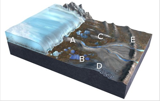
A)A
B)B
C)C
D)D
E)E
A)A
B)B
C)C
D)D
E)E
Question
What is the feature numbered 1 in the upper part of this figure? 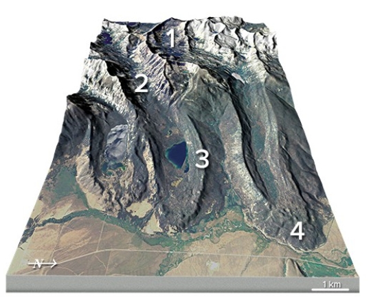
A)Cirque
B)U-shaped valley
C)Lateral moraine
D)Terminal moraine
A)Cirque
B)U-shaped valley
C)Lateral moraine
D)Terminal moraine
Question
Question
Which numbered feature(s)on this photograph are consistent with the presence of glaciers sometime in the past? 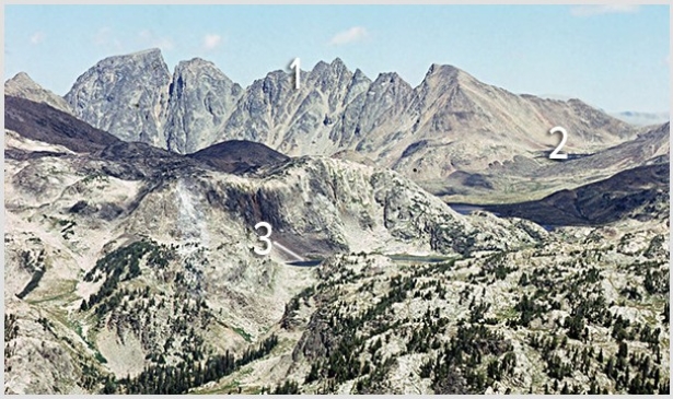
A)1,an arête
B)2,U-shaped valley
C)3,tarn
D)All of these are correct.
A)1,an arête
B)2,U-shaped valley
C)3,tarn
D)All of these are correct.
Question
Question
Which of the numbered features is a lateral moraine? 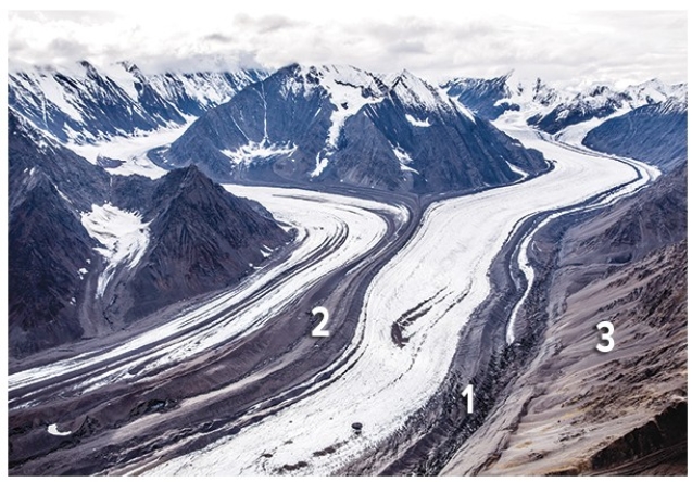
A)1
B)2
C)3
D)1 and 3
A)1
B)2
C)3
D)1 and 3
Question
Which of the features labeled on this figure is a terminal or recessional moraine? 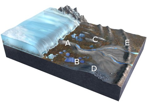
A)A
B)B
C)C
D)D
E)E
A)A
B)B
C)C
D)D
E)E
Question
What is the feature numbered 4 in the lower right of this figure? 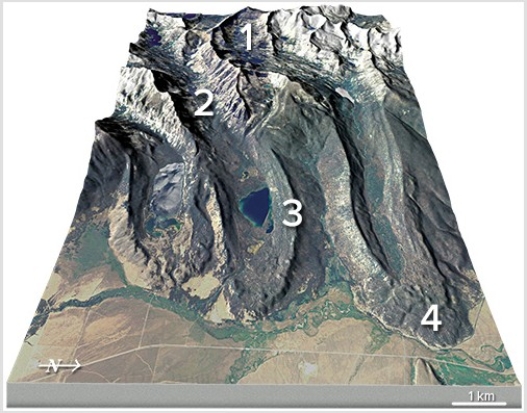
A)Cirque
B)U-shaped valley
C)Lateral moraine
D)Terminal moraine
A)Cirque
B)U-shaped valley
C)Lateral moraine
D)Terminal moraine
Question
Question
Question
What do these curved ridges (eskers)suggest happened on the landscape? 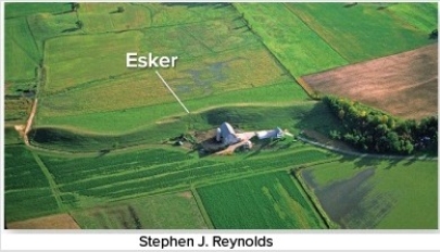
A)Ancient shorelines were present.
B)Meltwater channels were below or within a glacier.
C)Soft glacial sediment was shaped by the moving glacier.
D)Glacially derived,wind-blown dust was abundant.
A)Ancient shorelines were present.
B)Meltwater channels were below or within a glacier.
C)Soft glacial sediment was shaped by the moving glacier.
D)Glacially derived,wind-blown dust was abundant.
Question
What is the feature numbered 2 in this photograph? 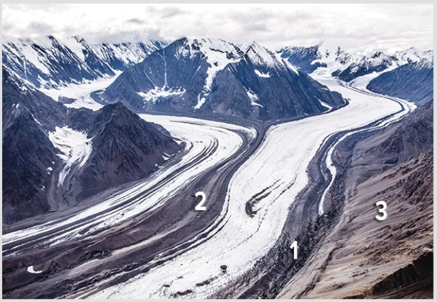
A)Medial moraine
B)Terminal moraine
C)Recessional moraine
D)Esker
E)Kettle
A)Medial moraine
B)Terminal moraine
C)Recessional moraine
D)Esker
E)Kettle
Question
What is the feature numbered 3 in the center of this figure? 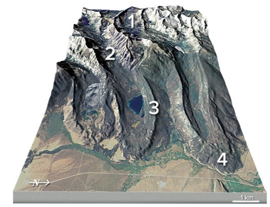
A)Cirque
B)U-shaped valley
C)Lateral moraine
D)Terminal moraine
A)Cirque
B)U-shaped valley
C)Lateral moraine
D)Terminal moraine
Question
Question
Which of the features labeled on this figure is a drumlin? 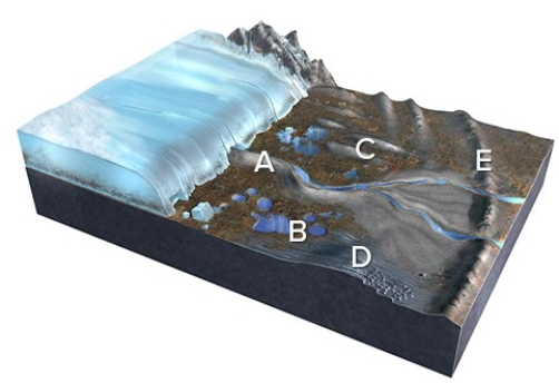
A)A
B)B
C)C
D)D
E)E
A)A
B)B
C)C
D)D
E)E
Question
Question
Which of the features labeled on this figure is a kettle? 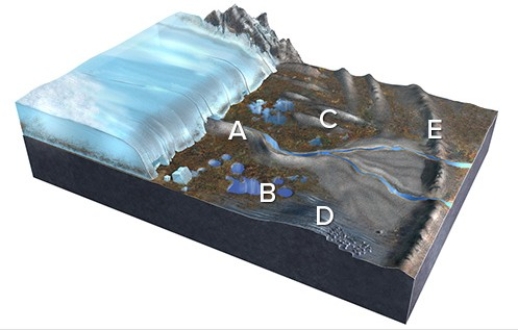
A)A
B)B
C)C
D)D
E)E
A)A
B)B
C)C
D)D
E)E
Question
What do these teardrop-shaped hills (drumlins)record? 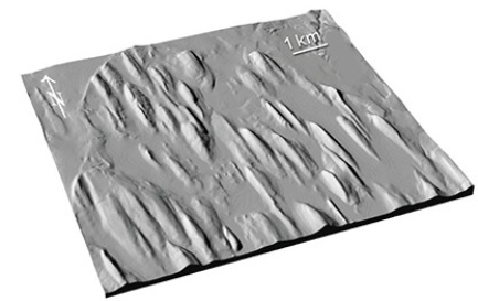
A)Ancient lake levels
B)Piles of sediment recording past positions of the end of the glacier
C)Erosion and sculpting of soft materials by a moving glacier
D)Melting of large blocks of rock in the ice
A)Ancient lake levels
B)Piles of sediment recording past positions of the end of the glacier
C)Erosion and sculpting of soft materials by a moving glacier
D)Melting of large blocks of rock in the ice
Question
Question
Question
Question
The present-day tilt of Earth's axis of rotation is 23.5°.What would be a result of less tilt,as shown here? 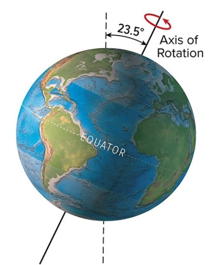
A)High latitudes would receive less direct sunlight during the summer,causing cooler temperatures
B)A decrease in glaciers
C)More hours of sunlight on the equator,resulting in warmer global temperatures
D)All of these are correct.
A)High latitudes would receive less direct sunlight during the summer,causing cooler temperatures
B)A decrease in glaciers
C)More hours of sunlight on the equator,resulting in warmer global temperatures
D)All of these are correct.
Question
If an ice block 10 centimeters wide,10 centimeters high,and 20 centimeters long melted,how much would it raise the water level in a tank that is 100 centimeters long by 40 centimeters wide? 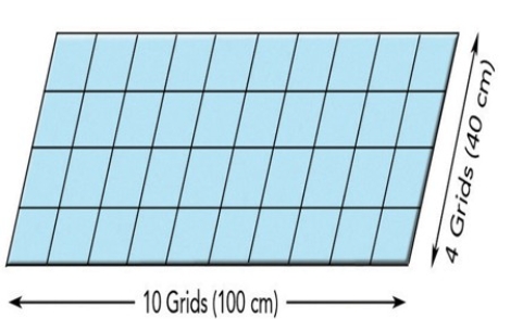
A)Less than 0.1 centimeters
B)0.1 to 1 centimeter
C)1 to 2 centimeters
D)2 to 4 centimeters
E)4 to 10 centimeters
A)Less than 0.1 centimeters
B)0.1 to 1 centimeter
C)1 to 2 centimeters
D)2 to 4 centimeters
E)4 to 10 centimeters
Question
Question
What happens to different isotopes of oxygen in this figure? 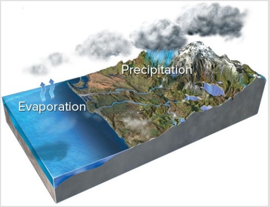
A)Evaporation concentrates lighter isotopes in the resulting water vapor.
B)Precipitation forms ice that is enriched in heavier isotopes relative to seawater.
C)Melting of ice preferentially releases heavier isotopes back into the ocean.
D)All of these are correct.
A)Evaporation concentrates lighter isotopes in the resulting water vapor.
B)Precipitation forms ice that is enriched in heavier isotopes relative to seawater.
C)Melting of ice preferentially releases heavier isotopes back into the ocean.
D)All of these are correct.
Question
Question
Question
The present-day tilt of Earth's axis of rotation is 23.5° degrees.What would be a result of more tilt,as shown here? 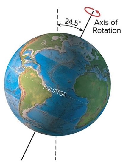
A)High latitudes would receive fewer hours of sunlight in winter
B)A decrease in glacial activity
C)An increase in the summer to winter temperature differences
D)All of these are correct.
A)High latitudes would receive fewer hours of sunlight in winter
B)A decrease in glacial activity
C)An increase in the summer to winter temperature differences
D)All of these are correct.
Question
Question
The present-day tilt of Earth's axis of rotation is 23.5°.What would be a result of more tilt,as shown here? 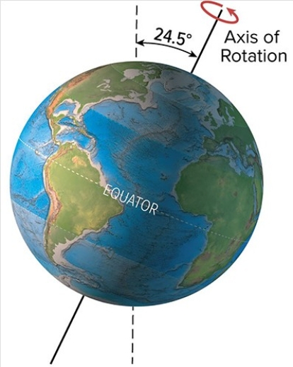
A)High latitudes would receive less direct sunlight during the summer,causing cooler temperatures
B)A decrease in glaciers
C)A decrease in the effects of the seasons
D)All of these are correct.
A)High latitudes would receive less direct sunlight during the summer,causing cooler temperatures
B)A decrease in glaciers
C)A decrease in the effects of the seasons
D)All of these are correct.
Question
Question
If an ice block 10 centimeters on each side melted,how much would it raise the water level in a tank that is 100 centimeters long by 40 centimeters wide? 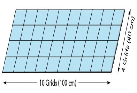
A)Less than 0.5 centimeters
B)0.5 to 1 centimeter
C)1 to 2 centimeters
D)2 to 4 centimeters
E)4 to 10 centimeters
A)Less than 0.5 centimeters
B)0.5 to 1 centimeter
C)1 to 2 centimeters
D)2 to 4 centimeters
E)4 to 10 centimeters
Question

Unlock Deck
Sign up to unlock the cards in this deck!
Unlock Deck
Unlock Deck
1/75
Play
Full screen (f)
Deck 14: Glaciers and Glacial Landforms
1
What happens when a glacier encounters the sea or a lake?
A)The ice is denser than water and so scrapes along the bottom.
B)White icebergs float but blue icebergs sink to the bottom.
C)Large blocks of ice collapse off the front of the glacier and become icebergs.
D)Rocks released from melted icebergs float on the water surface.
E)All of these are correct.
A)The ice is denser than water and so scrapes along the bottom.
B)White icebergs float but blue icebergs sink to the bottom.
C)Large blocks of ice collapse off the front of the glacier and become icebergs.
D)Rocks released from melted icebergs float on the water surface.
E)All of these are correct.
C
2
The circular-shaped mass of ice shown in the center of the photograph below is a(n)
A)cirque glacier.
B)ice sheet.
C)snowfield.
D)ice shelf.
A)cirque glacier.
B)ice sheet.
C)snowfield.
D)ice shelf.
A
3
What is one reason why the U.S.East Coast has so many bays and islands?
A)The land has been uplifted by recent faulting.
B)The land has been downdropped by recent faulting.
C)Water released from melting glaciers raised sea level.
D)A large tsunami from a meteoroid impact scoured the coastline.
A)The land has been uplifted by recent faulting.
B)The land has been downdropped by recent faulting.
C)Water released from melting glaciers raised sea level.
D)A large tsunami from a meteoroid impact scoured the coastline.
C
4
Which of the following is not a way glaciers move downhill?
A)The glacier can slide over bedrock.
B)A glacier can move by internal shear and flow.
C)The upper parts of glaciers can fracture.
D)The lower part of a glacier flows faster than the upper part.
A)The glacier can slide over bedrock.
B)A glacier can move by internal shear and flow.
C)The upper parts of glaciers can fracture.
D)The lower part of a glacier flows faster than the upper part.
Unlock Deck
Unlock for access to all 75 flashcards in this deck.
Unlock Deck
k this deck
5
What is the origin of smooth troughs cutting across the landscape in the Great Lakes area?
A)The areas were covered by soft marine sediments.
B)A huge flood coming from Iowa flowed toward the Great Lakes.
C)Glaciers carved out the smooth troughs.
D)All of these are correct.
A)The areas were covered by soft marine sediments.
B)A huge flood coming from Iowa flowed toward the Great Lakes.
C)Glaciers carved out the smooth troughs.
D)All of these are correct.
Unlock Deck
Unlock for access to all 75 flashcards in this deck.
Unlock Deck
k this deck
6
In the map below,the two ice sheets shown are called the
A)Cordilleran in the west and Laurentide in the east.
B)Laurentide in the west and Cordilleran in the east.
C)Yukon in the west and Aftonian in the east.
D)Sangamon in the west and Icelandic in the east.
A)Cordilleran in the west and Laurentide in the east.
B)Laurentide in the west and Cordilleran in the east.
C)Yukon in the west and Aftonian in the east.
D)Sangamon in the west and Icelandic in the east.
Unlock Deck
Unlock for access to all 75 flashcards in this deck.
Unlock Deck
k this deck
7
What is the origin of curved ridges (R on this figure)in the Great Lakes area?
A)Folds produced during a continental collision
B)Paths of ancient rivers
C)Piles of sediment deposited by retreating glaciers
D)Remnants of a meteoroid impact
A)Folds produced during a continental collision
B)Paths of ancient rivers
C)Piles of sediment deposited by retreating glaciers
D)Remnants of a meteoroid impact
Unlock Deck
Unlock for access to all 75 flashcards in this deck.
Unlock Deck
k this deck
8
What type of glacier is shown below on the gently sloping land near the coastline?
A)Tropical coast glacier
B)Shoreline glacier
C)Piedmont glacier
D)Continental ice sheet
A)Tropical coast glacier
B)Shoreline glacier
C)Piedmont glacier
D)Continental ice sheet
Unlock Deck
Unlock for access to all 75 flashcards in this deck.
Unlock Deck
k this deck
9
What happens on either side of the equilibrium line in a glacier?
A)Sublimation occurs only above the line,and melting occurs only below the line.
B)Melting occurs only above the line,and sublimation occurs only below the line.
C)Above the equilibrium line,the amount of accumulation exceeds the amount lost by various processes.
D)Air temperatures are below freezing below the line and above freezing above the line.
Unlock Deck
Unlock for access to all 75 flashcards in this deck.
Unlock Deck
k this deck
10
The feature below has angular rocks on the outside and slowly flowing ice on the inside.It is called a(n)
A)ice glacier.
B)nunatak.
C)cirque glacier.
D)rock glacier.
A)ice glacier.
B)nunatak.
C)cirque glacier.
D)rock glacier.
Unlock Deck
Unlock for access to all 75 flashcards in this deck.
Unlock Deck
k this deck
11
What is the origin of smooth troughs (T on this figure)cutting across the landscape in the Great Lakes area?
A)The areas were covered by soft marine sediments.
B)A huge flood coming from Iowa flowed toward the Great Lakes.
C)Glaciers carved out the smooth troughs.
D)All of these are correct.
A)The areas were covered by soft marine sediments.
B)A huge flood coming from Iowa flowed toward the Great Lakes.
C)Glaciers carved out the smooth troughs.
D)All of these are correct.
Unlock Deck
Unlock for access to all 75 flashcards in this deck.
Unlock Deck
k this deck
12
What type of glacier is shown in the center of this image?
A)Ribbon glacier
B)Valley glacier
C)Low-elevation glacier
D)High-elevation glacier
A)Ribbon glacier
B)Valley glacier
C)Low-elevation glacier
D)High-elevation glacier
Unlock Deck
Unlock for access to all 75 flashcards in this deck.
Unlock Deck
k this deck
13
The most striking feature of the Pleistocene Epoch was
A)the near-total absence of glaciers and ice on Earth.
B)the expansion of glaciers and ice on Earth.
C)the expansion of mountain glaciers but retreat of continental glaciers around the world.
D)the expansion of continental glaciers but retreat of mountain glaciers around the world.
A)the near-total absence of glaciers and ice on Earth.
B)the expansion of glaciers and ice on Earth.
C)the expansion of mountain glaciers but retreat of continental glaciers around the world.
D)the expansion of continental glaciers but retreat of mountain glaciers around the world.
Unlock Deck
Unlock for access to all 75 flashcards in this deck.
Unlock Deck
k this deck
14
When the upper surface of the open ocean freezes,the feature produced is called
A)sea ice,composed mostly of fresh water.
B)sea ice,composed mostly of salty water.
C)ice calving,composed mostly of fresh water.
D)ice calving,composed mostly of salty water.
A)sea ice,composed mostly of fresh water.
B)sea ice,composed mostly of salty water.
C)ice calving,composed mostly of fresh water.
D)ice calving,composed mostly of salty water.
Unlock Deck
Unlock for access to all 75 flashcards in this deck.
Unlock Deck
k this deck
15
A geographic feature that formed as a result of the melting of the ice sheets during the Holocene Epoch is the
A)Great Lakes.
B)Mississippi River.
C)St.Lawrence River.
D)All of these are correct.
A)Great Lakes.
B)Mississippi River.
C)St.Lawrence River.
D)All of these are correct.
Unlock Deck
Unlock for access to all 75 flashcards in this deck.
Unlock Deck
k this deck
16
An interglacial period is
A)a time in Earth history when there is no ice age.
B)a warm period of a few months,such as summer,during an ice age.
C)a time when the glaciers are small but still existing,but not in an ice age.
D)a time when the glaciers are small but still existing,still within an ice age.
A)a time in Earth history when there is no ice age.
B)a warm period of a few months,such as summer,during an ice age.
C)a time when the glaciers are small but still existing,but not in an ice age.
D)a time when the glaciers are small but still existing,still within an ice age.
Unlock Deck
Unlock for access to all 75 flashcards in this deck.
Unlock Deck
k this deck
17
How does a crevasse form?
A)A glacier moves over a volcanic hot spot,causing differential melting and caving it inward.
B)A glacier moves across a ridge of particularly resistant rock,which breaks the glacier from the bottom upward.
C)Internal stress causes a glacier's upper surface to break as the glacier moves.
D)A glacier moves over a pre-existing stream valley,which causes it to fracture on each side of the valley.
Unlock Deck
Unlock for access to all 75 flashcards in this deck.
Unlock Deck
k this deck
18
The exposed bedrock in the background of the figure below,to the right,formed as
A)isostatic rebound caused the land to extend upward.
B)particularly resistant rock and/or thin ice left the rock above the ice surface.
C)a mantle hot spot melted the glacier in this localized area.
D)local wind-blown deposition concentrated in this area of the glacier.
A)isostatic rebound caused the land to extend upward.
B)particularly resistant rock and/or thin ice left the rock above the ice surface.
C)a mantle hot spot melted the glacier in this localized area.
D)local wind-blown deposition concentrated in this area of the glacier.
Unlock Deck
Unlock for access to all 75 flashcards in this deck.
Unlock Deck
k this deck
19
What part of the Earth does not have glaciers or ice sheets today?
A)Tropics.
B)Midlatitudes.
C)Polar areas.
D)Tropics and midlatitudes.
E)All of these areas have glaciers or ice sheets today.
A)Tropics.
B)Midlatitudes.
C)Polar areas.
D)Tropics and midlatitudes.
E)All of these areas have glaciers or ice sheets today.
Unlock Deck
Unlock for access to all 75 flashcards in this deck.
Unlock Deck
k this deck
20
Which of these areas was least likely to have been covered by ice during the last glacial maximum in the Pleistocene Epoch?
A)Ontario,Canada
B)Quebec,Canada
C)Alaska,United States
D)Michigan,United States
A)Ontario,Canada
B)Quebec,Canada
C)Alaska,United States
D)Michigan,United States
Unlock Deck
Unlock for access to all 75 flashcards in this deck.
Unlock Deck
k this deck
21
What feature will be formed by the sediment carried along the sides of this glacier?
A)Cirque
B)Tarn
C)Arête
D)Lateral moraine
E)None of these are correct.
A)Cirque
B)Tarn
C)Arête
D)Lateral moraine
E)None of these are correct.
Unlock Deck
Unlock for access to all 75 flashcards in this deck.
Unlock Deck
k this deck
22
In the photograph below,the ice must have flowed
A)from the background into the foreground (i.e.,out of the screen and toward you).
B)from the foreground into the background (i.e.,away from you as you are looking at it).
C)from left to right.
D)from right to left.
A)from the background into the foreground (i.e.,out of the screen and toward you).
B)from the foreground into the background (i.e.,away from you as you are looking at it).
C)from left to right.
D)from right to left.
Unlock Deck
Unlock for access to all 75 flashcards in this deck.
Unlock Deck
k this deck
23
Till is
A)sorted but not stratified.
B)stratified but not sorted.
C)sorted and stratified.
D)neither sorted nor stratified.
A)sorted but not stratified.
B)stratified but not sorted.
C)sorted and stratified.
D)neither sorted nor stratified.
Unlock Deck
Unlock for access to all 75 flashcards in this deck.
Unlock Deck
k this deck
24
What is the relationship between plucking and abrasion on a glacially scoured landscape?
A)Plucking occurs relatively suddenly when a glacier first encounters the landscape,and then if it remains in place for a long time,abrasion begins to happen later over a long period of time.
B)Abrasion occurs relatively suddenly when a glacier first encounters the landscape,and then if it remains in place for a long time,plucking begins to happen later over a long period of time.
C)Plucking occurs on the upflow side of a mound or hill that is scoured,while abrasion occurs on the downflow side.
D)Abrasion occurs on the upflow side of a mound or hill that is scoured,while plucking occurs on the downflow side.
Unlock Deck
Unlock for access to all 75 flashcards in this deck.
Unlock Deck
k this deck
25
The primary reason that this feature formed is that
A)abrasion occurred on all sides,without plucking.
B)three or more cirques merged by headward erosion.
C)precipitation at the top of the mountain ran downward very quickly.
D)a series of faults surrounded a very localized area and uplifted it.
A)abrasion occurred on all sides,without plucking.
B)three or more cirques merged by headward erosion.
C)precipitation at the top of the mountain ran downward very quickly.
D)a series of faults surrounded a very localized area and uplifted it.
Unlock Deck
Unlock for access to all 75 flashcards in this deck.
Unlock Deck
k this deck
26
What carved this U-shaped valley?
A)A rapidly downcutting river
B)A slowly downcutting river
C)Wind
D)Glacier
A)A rapidly downcutting river
B)A slowly downcutting river
C)Wind
D)Glacier
Unlock Deck
Unlock for access to all 75 flashcards in this deck.
Unlock Deck
k this deck
27
The main reason that the deposits shown here are sorted and stratified is that the glacier that dropped them was
A)moving very slowly.
B)accompanied by running meltwater.
C)moving through very soft,erodible bedrock.
D)moving through very flat terrain.
A)moving very slowly.
B)accompanied by running meltwater.
C)moving through very soft,erodible bedrock.
D)moving through very flat terrain.
Unlock Deck
Unlock for access to all 75 flashcards in this deck.
Unlock Deck
k this deck
28
Which feature on this diagram is a cirque?
A)1,the circular depression at the head of the valley
B)2,a lake in the upper valley
C)3,a steep ridge
D)4,a valley that is above the level of the main valley
A)1,the circular depression at the head of the valley
B)2,a lake in the upper valley
C)3,a steep ridge
D)4,a valley that is above the level of the main valley
Unlock Deck
Unlock for access to all 75 flashcards in this deck.
Unlock Deck
k this deck
29
Abrasion is distinguished from plucking in that
A)abrasion is a smooth scraping,while plucking is a more jagged gouging of the bedrock.
B)abrasion is a jagged gouging,while plucking is a smooth scraping of the bedrock.
C)abrasion is an erosional feature,while plucking is a depositional feature.
D)abrasion is a depositional feature,while plucking is an erosional feature.
Unlock Deck
Unlock for access to all 75 flashcards in this deck.
Unlock Deck
k this deck
30
What happens to snowflakes as they become progressively buried within glaciers?
A)They become less dense because of large amounts of trapped air.
B)They begin to melt as they are insulated from the cold air.
C)They become interlocking crystals of ice.
D)They can become brighter white because of trapped air.
E)All of these are correct.
A)They become less dense because of large amounts of trapped air.
B)They begin to melt as they are insulated from the cold air.
C)They become interlocking crystals of ice.
D)They can become brighter white because of trapped air.
E)All of these are correct.
Unlock Deck
Unlock for access to all 75 flashcards in this deck.
Unlock Deck
k this deck
31
The lakes in the photograph below are all connected by a stream,so they are called
A)cols.
B)kames.
C)paternoster lakes.
D)cirques.
A)cols.
B)kames.
C)paternoster lakes.
D)cirques.
Unlock Deck
Unlock for access to all 75 flashcards in this deck.
Unlock Deck
k this deck
32
What is this bowl-shaped,glacially carved feature?
A)Hanging valley
B)Arête
C)Cirque
D)Continental ice sheet
A)Hanging valley
B)Arête
C)Cirque
D)Continental ice sheet
Unlock Deck
Unlock for access to all 75 flashcards in this deck.
Unlock Deck
k this deck
33
Which feature on this diagram is a hanging valley?
A)1,the circular depression at the head of the valley
B)2,a lake in the upper valley
C)3,a steep ridge
D)4,a valley that is above the level of the main valley
A)1,the circular depression at the head of the valley
B)2,a lake in the upper valley
C)3,a steep ridge
D)4,a valley that is above the level of the main valley
Unlock Deck
Unlock for access to all 75 flashcards in this deck.
Unlock Deck
k this deck
34
What name best describes the area of the lake in this photograph?
A)Terminal moraine
B)Equilibrium line
C)Fjord
D)Lateral moraine
E)Drumlin
A)Terminal moraine
B)Equilibrium line
C)Fjord
D)Lateral moraine
E)Drumlin
Unlock Deck
Unlock for access to all 75 flashcards in this deck.
Unlock Deck
k this deck
35
What are these sharp,glacially carved ridges?
A)Cirque
B)Arête
C)Hogback
D)Razorback
E)Flatiron
A)Cirque
B)Arête
C)Hogback
D)Razorback
E)Flatiron
Unlock Deck
Unlock for access to all 75 flashcards in this deck.
Unlock Deck
k this deck
36
The feature in the photograph below is a(n)
A)drumlin.
B)roche moutonnée.
C)esker.
D)kame.
A)drumlin.
B)roche moutonnée.
C)esker.
D)kame.
Unlock Deck
Unlock for access to all 75 flashcards in this deck.
Unlock Deck
k this deck
37
The type of glacial debris that can fall into a crevasse is
A)supraglacial debris.
B)englacial debris.
C)subglacial debris.
D)All of these are correct.
A)supraglacial debris.
B)englacial debris.
C)subglacial debris.
D)All of these are correct.
Unlock Deck
Unlock for access to all 75 flashcards in this deck.
Unlock Deck
k this deck
38
Which feature on this diagram is an arête?
A)1,the circular depression at the head of the valley
B)2,a lake in the upper valley
C)3,a steep ridge
D)4,a valley that is above the level of the main valley
A)1,the circular depression at the head of the valley
B)2,a lake in the upper valley
C)3,a steep ridge
D)4,a valley that is above the level of the main valley
Unlock Deck
Unlock for access to all 75 flashcards in this deck.
Unlock Deck
k this deck
39
The feature in the photograph below was formed by
A)plucking.
B)abrasion.
C)plucking on the left and abrasion on the right.
D)abrasion on the left and plucking on the right.
A)plucking.
B)abrasion.
C)plucking on the left and abrasion on the right.
D)abrasion on the left and plucking on the right.
Unlock Deck
Unlock for access to all 75 flashcards in this deck.
Unlock Deck
k this deck
40
Which feature on this diagram is a tarn?
A)1,the circular depression at the head of the valley
B)2,a lake in the upper valley
C)3,a steep ridge
D)4,a valley that is above the level of the main valley
A)1,the circular depression at the head of the valley
B)2,a lake in the upper valley
C)3,a steep ridge
D)4,a valley that is above the level of the main valley
Unlock Deck
Unlock for access to all 75 flashcards in this deck.
Unlock Deck
k this deck
41
What is the feature numbered 2 in the upper left part of this figure?
A)Cirque
B)U-shaped valley
C)Lateral moraine
D)Terminal moraine
A)Cirque
B)U-shaped valley
C)Lateral moraine
D)Terminal moraine
Unlock Deck
Unlock for access to all 75 flashcards in this deck.
Unlock Deck
k this deck
42
How are silt deposits called loess related to glaciers?
A)They accumulate in lakes trapped behind glaciers.
B)They form in lakes as the lakes dried up at the end of the ice ages.
C)They were deposited by large glacially caused floods in the Pacific Northwest.
D)They are wind-blown accumulations and commonly are derived from glaciers.
A)They accumulate in lakes trapped behind glaciers.
B)They form in lakes as the lakes dried up at the end of the ice ages.
C)They were deposited by large glacially caused floods in the Pacific Northwest.
D)They are wind-blown accumulations and commonly are derived from glaciers.
Unlock Deck
Unlock for access to all 75 flashcards in this deck.
Unlock Deck
k this deck
43
Which of the features labeled on this figure is an esker?
A)A
B)B
C)C
D)D
E)E
A)A
B)B
C)C
D)D
E)E
Unlock Deck
Unlock for access to all 75 flashcards in this deck.
Unlock Deck
k this deck
44
What is the feature numbered 1 in the upper part of this figure?
A)Cirque
B)U-shaped valley
C)Lateral moraine
D)Terminal moraine
A)Cirque
B)U-shaped valley
C)Lateral moraine
D)Terminal moraine
Unlock Deck
Unlock for access to all 75 flashcards in this deck.
Unlock Deck
k this deck
45
It is difficult to find an esker on a present-day landscape because
A)they were formed by glaciers only in very rare conditions.
B)they erode naturally very quickly.
C)they are usually overlain by other sediments from modern streams.
D)humans mine them as a source of gravel.
A)they were formed by glaciers only in very rare conditions.
B)they erode naturally very quickly.
C)they are usually overlain by other sediments from modern streams.
D)humans mine them as a source of gravel.
Unlock Deck
Unlock for access to all 75 flashcards in this deck.
Unlock Deck
k this deck
46
Which numbered feature(s)on this photograph are consistent with the presence of glaciers sometime in the past?
A)1,an arête
B)2,U-shaped valley
C)3,tarn
D)All of these are correct.
A)1,an arête
B)2,U-shaped valley
C)3,tarn
D)All of these are correct.
Unlock Deck
Unlock for access to all 75 flashcards in this deck.
Unlock Deck
k this deck
47
The margins of glaciers are usually darker than the interior primarily because
A)shearing causes the ice to expel air and become darker.
B)glaciers are transparent so the underlying bedrock is visible.
C)the sides are moving faster than the interior of the glacier.
D)the sides have a higher concentration of rocks and other debris.
E)All of these are correct.
A)shearing causes the ice to expel air and become darker.
B)glaciers are transparent so the underlying bedrock is visible.
C)the sides are moving faster than the interior of the glacier.
D)the sides have a higher concentration of rocks and other debris.
E)All of these are correct.
Unlock Deck
Unlock for access to all 75 flashcards in this deck.
Unlock Deck
k this deck
48
Which of the numbered features is a lateral moraine?
A)1
B)2
C)3
D)1 and 3
A)1
B)2
C)3
D)1 and 3
Unlock Deck
Unlock for access to all 75 flashcards in this deck.
Unlock Deck
k this deck
49
Which of the features labeled on this figure is a terminal or recessional moraine?
A)A
B)B
C)C
D)D
E)E
A)A
B)B
C)C
D)D
E)E
Unlock Deck
Unlock for access to all 75 flashcards in this deck.
Unlock Deck
k this deck
50
What is the feature numbered 4 in the lower right of this figure?
A)Cirque
B)U-shaped valley
C)Lateral moraine
D)Terminal moraine
A)Cirque
B)U-shaped valley
C)Lateral moraine
D)Terminal moraine
Unlock Deck
Unlock for access to all 75 flashcards in this deck.
Unlock Deck
k this deck
51
How is a terminal or recessional moraine from a continental ice sheet typically expressed in the landscape?
A)As teardrop-shaped hills
B)As a series of small depressions,many of which are lakes
C)As a series of jagged ridges in the mountains
D)As a series of gently curved ridges
E)As hills that are smooth on one side and rough on the other side
A)As teardrop-shaped hills
B)As a series of small depressions,many of which are lakes
C)As a series of jagged ridges in the mountains
D)As a series of gently curved ridges
E)As hills that are smooth on one side and rough on the other side
Unlock Deck
Unlock for access to all 75 flashcards in this deck.
Unlock Deck
k this deck
52
What does a terminal moraine represent?
A)The end of a polished and scratched segment of bedrock
B)The sharp ends of a jagged ridge formed by glaciers
C)The end of an ice sheet that is floating in the sea
D)A pile of sediment deposited at the end of the glacier
E)The final time that two glaciers come together
A)The end of a polished and scratched segment of bedrock
B)The sharp ends of a jagged ridge formed by glaciers
C)The end of an ice sheet that is floating in the sea
D)A pile of sediment deposited at the end of the glacier
E)The final time that two glaciers come together
Unlock Deck
Unlock for access to all 75 flashcards in this deck.
Unlock Deck
k this deck
53
What do these curved ridges (eskers)suggest happened on the landscape?
A)Ancient shorelines were present.
B)Meltwater channels were below or within a glacier.
C)Soft glacial sediment was shaped by the moving glacier.
D)Glacially derived,wind-blown dust was abundant.
A)Ancient shorelines were present.
B)Meltwater channels were below or within a glacier.
C)Soft glacial sediment was shaped by the moving glacier.
D)Glacially derived,wind-blown dust was abundant.
Unlock Deck
Unlock for access to all 75 flashcards in this deck.
Unlock Deck
k this deck
54
What is the feature numbered 2 in this photograph?
A)Medial moraine
B)Terminal moraine
C)Recessional moraine
D)Esker
E)Kettle
A)Medial moraine
B)Terminal moraine
C)Recessional moraine
D)Esker
E)Kettle
Unlock Deck
Unlock for access to all 75 flashcards in this deck.
Unlock Deck
k this deck
55
What is the feature numbered 3 in the center of this figure?
A)Cirque
B)U-shaped valley
C)Lateral moraine
D)Terminal moraine
A)Cirque
B)U-shaped valley
C)Lateral moraine
D)Terminal moraine
Unlock Deck
Unlock for access to all 75 flashcards in this deck.
Unlock Deck
k this deck
56
What are some features that were or are associated with the emptying of lakes formed during glacial times?
A)The Bonneville Salt Flats of Utah
B)The Channeled Scablands
C)Enormous potholes carved into bedrock
D)Enormous ripples hundreds of feet high
E)All of these are correct.
A)The Bonneville Salt Flats of Utah
B)The Channeled Scablands
C)Enormous potholes carved into bedrock
D)Enormous ripples hundreds of feet high
E)All of these are correct.
Unlock Deck
Unlock for access to all 75 flashcards in this deck.
Unlock Deck
k this deck
57
Which of the features labeled on this figure is a drumlin?
A)A
B)B
C)C
D)D
E)E
A)A
B)B
C)C
D)D
E)E
Unlock Deck
Unlock for access to all 75 flashcards in this deck.
Unlock Deck
k this deck
58
What is permafrost?
A)Curly crystals of frost that form early in the morning
B)Ice and snow that exist throughout the entire year
C)Ice and snow that are permanently in motion
D)The upper part of the ground that remains frozen throughout the year
A)Curly crystals of frost that form early in the morning
B)Ice and snow that exist throughout the entire year
C)Ice and snow that are permanently in motion
D)The upper part of the ground that remains frozen throughout the year
Unlock Deck
Unlock for access to all 75 flashcards in this deck.
Unlock Deck
k this deck
59
Which of the features labeled on this figure is a kettle?
A)A
B)B
C)C
D)D
E)E
A)A
B)B
C)C
D)D
E)E
Unlock Deck
Unlock for access to all 75 flashcards in this deck.
Unlock Deck
k this deck
60
What do these teardrop-shaped hills (drumlins)record?
A)Ancient lake levels
B)Piles of sediment recording past positions of the end of the glacier
C)Erosion and sculpting of soft materials by a moving glacier
D)Melting of large blocks of rock in the ice
A)Ancient lake levels
B)Piles of sediment recording past positions of the end of the glacier
C)Erosion and sculpting of soft materials by a moving glacier
D)Melting of large blocks of rock in the ice
Unlock Deck
Unlock for access to all 75 flashcards in this deck.
Unlock Deck
k this deck
61
What are some possible influences of ocean currents on glaciation?
A)Cold currents can cool the land,allowing glaciers to form if there is sufficient precipitation.
B)Cold currents can inhibit the growth of glaciers because they put less moisture into the atmosphere.
C)Warm currents can warm parts of continents,inhibiting glaciation.
D)Warm currents bring warm moist air that can increase precipitation and snowfall if the temperature is cold enough.
E)All of these are correct.
Unlock Deck
Unlock for access to all 75 flashcards in this deck.
Unlock Deck
k this deck
62
What is one of the most important aspects about West Antarctica with respect to global sea level?
A)It has large composite volcanoes whose eruptions have changed global climate.
B)It cools the adjacent oceans,causing them to contract.
C)It has large floating ice shelves that could be detached and melted.
D)It has large volcanoes whose eruption beneath the ice could cause extremely large floods.
A)It has large composite volcanoes whose eruptions have changed global climate.
B)It cools the adjacent oceans,causing them to contract.
C)It has large floating ice shelves that could be detached and melted.
D)It has large volcanoes whose eruption beneath the ice could cause extremely large floods.
Unlock Deck
Unlock for access to all 75 flashcards in this deck.
Unlock Deck
k this deck
63
How could changes in Earth's tilt influence global climate?
A)A high angle of tilt causes snow and ice to fall off the planet.
B)A minimum angle of tilt causes high latitudes to receive less sunlight during the summer,causing an increase in glaciers.
C)A maximum angle of tilt causes Earth to reflect more sunlight into space,causing an increase in glaciers.
D)A high angle of tilt causes the continents to move away from the poles leading to more glaciers.
Unlock Deck
Unlock for access to all 75 flashcards in this deck.
Unlock Deck
k this deck
64
The present-day tilt of Earth's axis of rotation is 23.5°.What would be a result of less tilt,as shown here?
A)High latitudes would receive less direct sunlight during the summer,causing cooler temperatures
B)A decrease in glaciers
C)More hours of sunlight on the equator,resulting in warmer global temperatures
D)All of these are correct.
A)High latitudes would receive less direct sunlight during the summer,causing cooler temperatures
B)A decrease in glaciers
C)More hours of sunlight on the equator,resulting in warmer global temperatures
D)All of these are correct.
Unlock Deck
Unlock for access to all 75 flashcards in this deck.
Unlock Deck
k this deck
65
If an ice block 10 centimeters wide,10 centimeters high,and 20 centimeters long melted,how much would it raise the water level in a tank that is 100 centimeters long by 40 centimeters wide?
A)Less than 0.1 centimeters
B)0.1 to 1 centimeter
C)1 to 2 centimeters
D)2 to 4 centimeters
E)4 to 10 centimeters
A)Less than 0.1 centimeters
B)0.1 to 1 centimeter
C)1 to 2 centimeters
D)2 to 4 centimeters
E)4 to 10 centimeters
Unlock Deck
Unlock for access to all 75 flashcards in this deck.
Unlock Deck
k this deck
66
What would happen to global sea levels if all the ice in West Antarctica melts?
A)It would not change because the volume of water you get from melting ice is only slightly more than the volume of the ice.
B)It would not change because the volume of water you get from melting ice is only slightly less than the volume of the ice.
C)Sea level would fall because of isostatic rebound.
D)Sea level would rise by a significant amount.
Unlock Deck
Unlock for access to all 75 flashcards in this deck.
Unlock Deck
k this deck
67
What happens to different isotopes of oxygen in this figure?
A)Evaporation concentrates lighter isotopes in the resulting water vapor.
B)Precipitation forms ice that is enriched in heavier isotopes relative to seawater.
C)Melting of ice preferentially releases heavier isotopes back into the ocean.
D)All of these are correct.
A)Evaporation concentrates lighter isotopes in the resulting water vapor.
B)Precipitation forms ice that is enriched in heavier isotopes relative to seawater.
C)Melting of ice preferentially releases heavier isotopes back into the ocean.
D)All of these are correct.
Unlock Deck
Unlock for access to all 75 flashcards in this deck.
Unlock Deck
k this deck
68
The amount of solar heating can increase from
A)a decrease in sunspot activity and energy output from the Sun.
B)a decrease in snow and ice cover on Earth's surface.
C)a decrease in the amount of greenhouse gases.
D)a huge volcanic eruption that adds ash and dust to the atmosphere.
A)a decrease in sunspot activity and energy output from the Sun.
B)a decrease in snow and ice cover on Earth's surface.
C)a decrease in the amount of greenhouse gases.
D)a huge volcanic eruption that adds ash and dust to the atmosphere.
Unlock Deck
Unlock for access to all 75 flashcards in this deck.
Unlock Deck
k this deck
69
If all the ice on the planet melted,how much would it cause global sea level to rise? If you do not remember the approximate size of this rise,the volume of ice is 32,000,000 km3 and the surface area of the world's ocean is 361,000,000 km2.
A)Less than 10 centimeters
B)10 centimeters to 1 meter
C)1 meter to 10 meters
D)10 meters to 100 meters
E)More than 100 meters
A)Less than 10 centimeters
B)10 centimeters to 1 meter
C)1 meter to 10 meters
D)10 meters to 100 meters
E)More than 100 meters
Unlock Deck
Unlock for access to all 75 flashcards in this deck.
Unlock Deck
k this deck
70
The present-day tilt of Earth's axis of rotation is 23.5° degrees.What would be a result of more tilt,as shown here?
A)High latitudes would receive fewer hours of sunlight in winter
B)A decrease in glacial activity
C)An increase in the summer to winter temperature differences
D)All of these are correct.
A)High latitudes would receive fewer hours of sunlight in winter
B)A decrease in glacial activity
C)An increase in the summer to winter temperature differences
D)All of these are correct.
Unlock Deck
Unlock for access to all 75 flashcards in this deck.
Unlock Deck
k this deck
71
Which of the following is not a type of evidence left behind by glaciers?
A)Scratched and polished bedrock
B)Scattered stones (dropstones)in fine-grained sediment
C)Changes in the isotopic compositions of marine shells
D)V-shaped valleys
E)All of these are evidence left behind by glaciers.
A)Scratched and polished bedrock
B)Scattered stones (dropstones)in fine-grained sediment
C)Changes in the isotopic compositions of marine shells
D)V-shaped valleys
E)All of these are evidence left behind by glaciers.
Unlock Deck
Unlock for access to all 75 flashcards in this deck.
Unlock Deck
k this deck
72
The present-day tilt of Earth's axis of rotation is 23.5°.What would be a result of more tilt,as shown here?
A)High latitudes would receive less direct sunlight during the summer,causing cooler temperatures
B)A decrease in glaciers
C)A decrease in the effects of the seasons
D)All of these are correct.
A)High latitudes would receive less direct sunlight during the summer,causing cooler temperatures
B)A decrease in glaciers
C)A decrease in the effects of the seasons
D)All of these are correct.
Unlock Deck
Unlock for access to all 75 flashcards in this deck.
Unlock Deck
k this deck
73
If the amount of ice on the planet increased to the amount that was present during the last glacial maximum,how much would it cause global sea level to fall? If you do not remember the approximate size of this rise,the volume of additional ice is 52,000,000 km3 and the surface area of the world's ocean is 361,000,000 km2.
A)Less than 10 centimeters
B)10 centimeters to 1 meter
C)1 meter to 10 meters
D)10 meters to 50 meters
E)More than 50 meters
A)Less than 10 centimeters
B)10 centimeters to 1 meter
C)1 meter to 10 meters
D)10 meters to 50 meters
E)More than 50 meters
Unlock Deck
Unlock for access to all 75 flashcards in this deck.
Unlock Deck
k this deck
74
If an ice block 10 centimeters on each side melted,how much would it raise the water level in a tank that is 100 centimeters long by 40 centimeters wide?
A)Less than 0.5 centimeters
B)0.5 to 1 centimeter
C)1 to 2 centimeters
D)2 to 4 centimeters
E)4 to 10 centimeters
A)Less than 0.5 centimeters
B)0.5 to 1 centimeter
C)1 to 2 centimeters
D)2 to 4 centimeters
E)4 to 10 centimeters
Unlock Deck
Unlock for access to all 75 flashcards in this deck.
Unlock Deck
k this deck
75
If all the ice on West Antarctica was melted,how much would it cause global sea level to rise? If you do not remember the approximate size of this rise,the volume of ice is 3,000,000 km3 and the surface area of the world's ocean is 361,000,000 km2.
A)Less than 1 centimeter
B)1 to 10 centimeters
C)10 centimeters to 1 meter
D)1 meter to 10 meters
E)More than 100 meters
A)Less than 1 centimeter
B)1 to 10 centimeters
C)10 centimeters to 1 meter
D)1 meter to 10 meters
E)More than 100 meters
Unlock Deck
Unlock for access to all 75 flashcards in this deck.
Unlock Deck
k this deck
Unlock Deck
Unlock for access to all 75 flashcards in this deck.


