Deck 7: Climates Around the World
Full screen (f)
Question
Question
Question
The ITC would be best developed for Foraleza,Brazil in 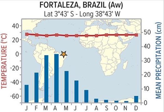
A)January.
B)March.
C)September.
D)November.
A)January.
B)March.
C)September.
D)November.
Question
The ITC would be best developed for Ho Chi Minh City,Vietnam in 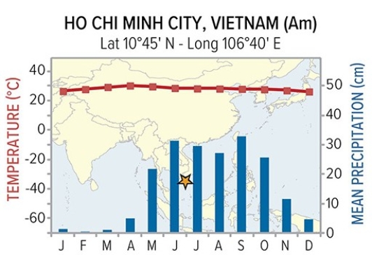
A)January.
B)March.
C)September.
D)November.
A)January.
B)March.
C)September.
D)November.
Question
Question
Question
Question
Question
Question
Question
Observe where the sun is overhead for most of the year in the Tropics.Temperatures are most constant along the 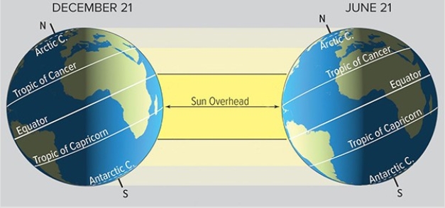
A)Arctic Circle.
B)Tropic of Cancer.
C)Equator.
D)Tropic of Capricorn.
E)Antarctic Circle.
A)Arctic Circle.
B)Tropic of Cancer.
C)Equator.
D)Tropic of Capricorn.
E)Antarctic Circle.
Question
Question
Colors on this map of an imaginary country represent mean annual temperatures (reds above 28 degrees Celsius,blue and purple below 0 degrees Celsius). In classifying the climate of this imaginary country,the wettest and coolest areas are in the 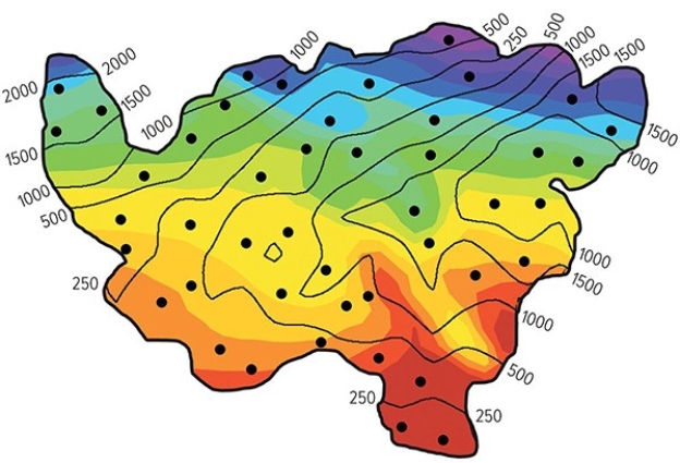
A)northeast.
B)southeast.
C)southwest.
A)northeast.
B)southeast.
C)southwest.
Question
Question
Question
Colors on this map of an imaginary country represent mean annual temperatures (reds above 28 degrees Celsius,blue and purple below 0 degrees Celsius). In classifying the climate of this imaginary country,the hottest and driest areas are in the 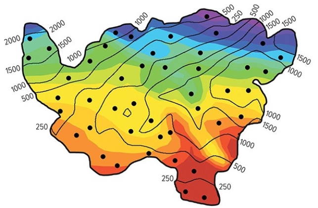
A)northeast.
B)southeast.
C)southwest.
D)northwest.
A)northeast.
B)southeast.
C)southwest.
D)northwest.
Question
Question
Given that climate correlates closely with vegetation,what letter approximates the type of vegetation you would see for an Am climate? 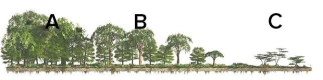
A)A
B)B
C)C
A)A
B)B
C)C
Question
Given that climate correlates closely with vegetation,what letter approximates the type of vegetation you would see for an Aw climate? 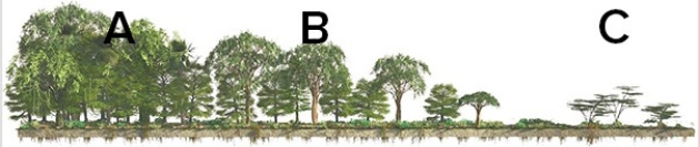
A)A
B)B
C)C
A)A
B)B
C)C
Question
Question
Question
Question
Which factor best explains the difference in March sea ice between March in the northern hemisphere and March in the southern hemisphere? 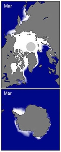
A)Low sun angle throughout the year
B)High albedo for all surfaces
C)Seasonal variation in daylength
D)Continentality for all surfaces
A)Low sun angle throughout the year
B)High albedo for all surfaces
C)Seasonal variation in daylength
D)Continentality for all surfaces
Question
Question
The Cwa climate of Lucknow,India owes its precipitation pattern to 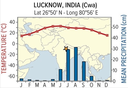
A)the dry eastern side of the subtropical high.
B)the moist western side of the subtropical high.
C)seasonal shifts in wind direction.
D)typhoons that bring high amounts of rain.
A)the dry eastern side of the subtropical high.
B)the moist western side of the subtropical high.
C)seasonal shifts in wind direction.
D)typhoons that bring high amounts of rain.
Question
What is the predominant wind direction that results in the rain shadow observed in this picture from one of the Hawaiian Islands? 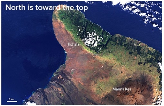
A)Southwest
B)Southeast
C)Northwest
D)Northeast
A)Southwest
B)Southeast
C)Northwest
D)Northeast
Question
Question
Question
The Csa climate of Athens Greece owes its summer precipitation pattern to 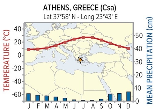
A)the dry eastern side of the subtropical high.
B)the moist western side of the subtropical high.
C)seasonal shifts in wind direction.
D)hurricanes that bring high amounts of rain.
A)the dry eastern side of the subtropical high.
B)the moist western side of the subtropical high.
C)seasonal shifts in wind direction.
D)hurricanes that bring high amounts of rain.
Question
Question
Question
Question
Question
Question
Question
Question
Though Khartoum and Urumqi both have dry BW climates,temperatures are much more variable for Urumqi.Why? 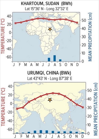
A)Urumqi's rain shadow
B)Urumqi's latitude
C)Khartoum's rain shadow
D)Khartoum's latitude
A)Urumqi's rain shadow
B)Urumqi's latitude
C)Khartoum's rain shadow
D)Khartoum's latitude
Question
Question
Question
Question
Pictured here is a model of how the atmosphere is heated.Which arrow represents heating of the earth's atmosphere by longwave radiation? 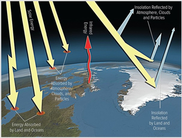
A)Insolation reflected by land
B)Insolation reflected by clouds
C)Energy absorbed by land
D)Infrared energy emitted by land
A)Insolation reflected by land
B)Insolation reflected by clouds
C)Energy absorbed by land
D)Infrared energy emitted by land
Question
Question
Question
Question
Calculate the percent increase in CO₂between 1960 (at 320 ppm)and 2010 (at 400 ppm).The best answer is 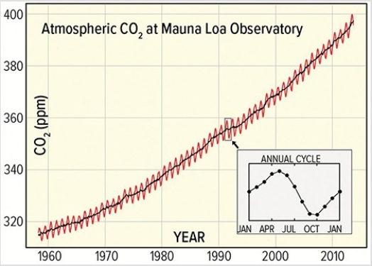
A)20%.
B)25%.
C)80%.
D)400%.
A)20%.
B)25%.
C)80%.
D)400%.
Question
Question
Question
Question
Question
Question
What does this map show about acid rain (low PH)? 
A)California suffers from of high levels of acid rain.
B)The Gulf Coast suffers from the highest levels of acid rain.
C)The Northeast has high levels of acid rain.
A)California suffers from of high levels of acid rain.
B)The Gulf Coast suffers from the highest levels of acid rain.
C)The Northeast has high levels of acid rain.
Question
Question
Thermometers directly measuring temperature data on a global scale show the most recent cooling period ended around 
A)1860.
B)1940.
C)1980.
D)2010.
A)1860.
B)1940.
C)1980.
D)2010.
Question
Question
The SO₂emissions displayed in this map derive mainly from the 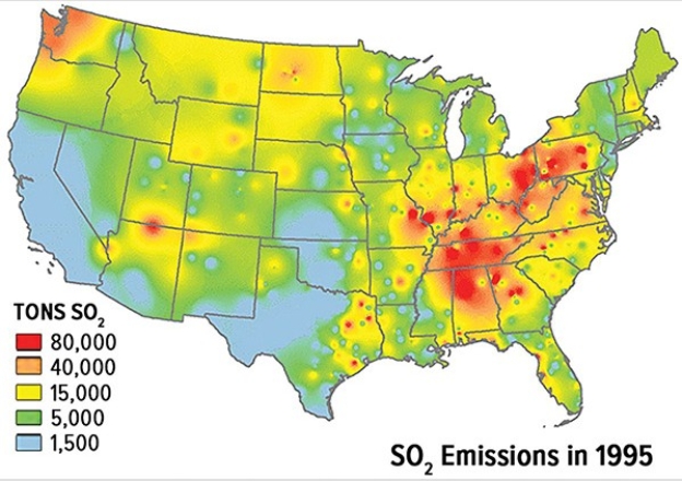
A)automobile emissions from point sources.
B)automobile emissions from nonpoint sources.
C)burning of coal from point sources.
D)burning of coal from nonpoint sources.
A)automobile emissions from point sources.
B)automobile emissions from nonpoint sources.
C)burning of coal from point sources.
D)burning of coal from nonpoint sources.
Question
Question
Between 1960 and 2010,atmospheric greenhouse CO₂has increased by 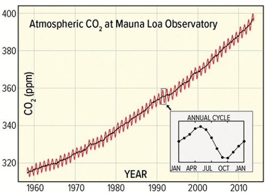
A)400 ppm.
B)320 ppm.
C)80 ppm.
A)400 ppm.
B)320 ppm.
C)80 ppm.
Question
Question
The main National Academy of Science conclusion on global warming since the mid-1800s states 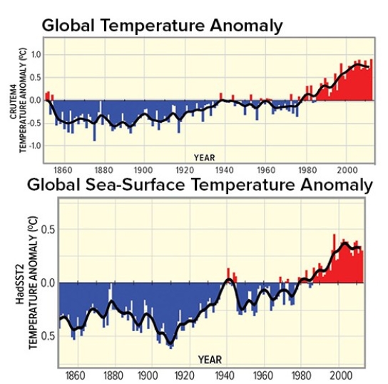
A)insufficient data exists to definitively state global warming has occurred.
B)temperatures have remain unchanged.
C)temperatures have risen around 0.5°C.
D)temperatures have risen 6°C.
A)insufficient data exists to definitively state global warming has occurred.
B)temperatures have remain unchanged.
C)temperatures have risen around 0.5°C.
D)temperatures have risen 6°C.
Question
Both sea surface (below)and air temperature (above)show a warming period beginning in 
A)1860.
B)1940.
C)1980.
D)2010.
A)1860.
B)1940.
C)1980.
D)2010.
Question
The biggest loss of sea ice between 1979 and 2015 appears to be along the 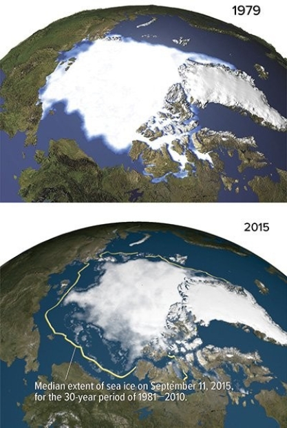
A)north shore of Russia.
B)east shore of Greenland.
C)west shore of Greenland.
D)north shore of Alaska.
A)north shore of Russia.
B)east shore of Greenland.
C)west shore of Greenland.
D)north shore of Alaska.
Question
Question
Question
The accompanying graph shows the number of violent tornados in the last 60 years.Based on when most global warming has occurred,one would conclude 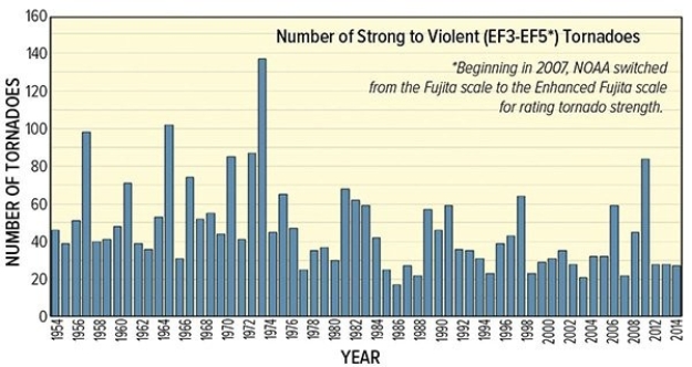
A)global warming has had a major impact on the number of tornados.
B)global warming has had a major impact on the number of tornados in the early part of the century.
C)global warming has had a major impact on the number of tornados since 2000.
D)global warming has not had an impact on the number of tornados.
Question
Question
Question
Question
Question
This globe,from the opening two-page spread of the Climate chapter,shows average annual precipitation (blue and green are highest; tan is lowest).What is the main factor causing northern Africa to have very low amounts of precipitation? 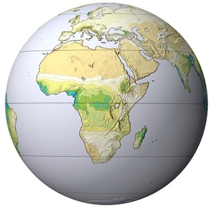
A)Trade winds
B)Westerlies
C)Downward flow of dry air in subtropics
D)Upward flow of dry air in the mid-latitudes
A)Trade winds
B)Westerlies
C)Downward flow of dry air in subtropics
D)Upward flow of dry air in the mid-latitudes
Question
Question
Question
The accompanying graph shows the number of Atlantic hurricanes since the 1880s.Based on when most global warming has occurred,one would conclude 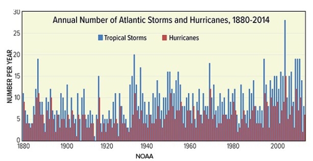
A)short duration hurricanes have increased in frequency.
B)all hurricanes have increased in frequency.
C)moderate duration hurricanes have increased in frequency.
D)no trends are apparent from this graph.
A)short duration hurricanes have increased in frequency.
B)all hurricanes have increased in frequency.
C)moderate duration hurricanes have increased in frequency.
D)no trends are apparent from this graph.
Question
Which of the following sites on this figure contains a desert? 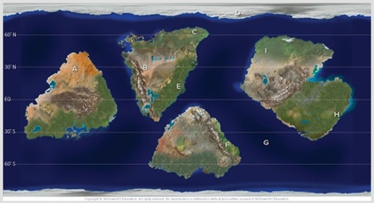
A)A
B)C
C)E
D)F
E)H
A)A
B)C
C)E
D)F
E)H
Question
This globe,from the opening two-page spread of the Climate chapter,shows average annual precipitation (blue and green are highest; tan is lowest).What feature best corresponds to the highest amount of precipitation? 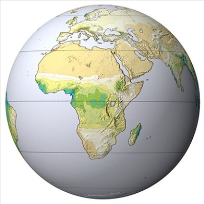
A)Trade winds
B)Westerlies
C)Intertropical Convergence Zone (ITCZ)
D)High mountains
A)Trade winds
B)Westerlies
C)Intertropical Convergence Zone (ITCZ)
D)High mountains
Question
This globe,from the opening two-page spread of the Climate chapter,shows average annual temperature (warmest is red,coolest is purple).What feature corresponds with the areas with the warmest temperatures? 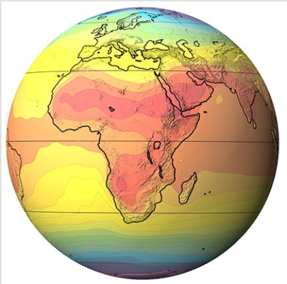
A)Equator
B)Subtropics
C)Mid-latitude
D)High latitudes
A)Equator
B)Subtropics
C)Mid-latitude
D)High latitudes
Question
Question
Question
Question
Question
This globe,from the opening two-page spread of the Climate chapter,shows average annual temperature (warmest is red,coolest is purple).What is the main factor causing Europe to be colder than Africa? 
A)Trade winds
B)Westerlies
C)Amount of insolation
D)Ocean currents
A)Trade winds
B)Westerlies
C)Amount of insolation
D)Ocean currents

Unlock Deck
Sign up to unlock the cards in this deck!
Unlock Deck
Unlock Deck
1/82
Play
Full screen (f)
Deck 7: Climates Around the World
1
Cooler water and stable atmospheric conditions bring dry B climate conditions to the
A)west coasts of southern hemisphere continents.
B)east coasts of southern hemisphere continents.
C)east coasts of northern hemisphere continents.
D)west coast of the Eurasian continent.
A)west coasts of southern hemisphere continents.
B)east coasts of southern hemisphere continents.
C)east coasts of northern hemisphere continents.
D)west coast of the Eurasian continent.
A
2
What line or region best corresponds with the location of D climates?
A)Continental interiors,northern hemisphere
B)High latitudes,southern hemisphere
C)Equator,high elevations
D)Coastal locations,southern hemisphere
A)Continental interiors,northern hemisphere
B)High latitudes,southern hemisphere
C)Equator,high elevations
D)Coastal locations,southern hemisphere
A
3
The ITC would be best developed for Foraleza,Brazil in
A)January.
B)March.
C)September.
D)November.
A)January.
B)March.
C)September.
D)November.
B
4
The ITC would be best developed for Ho Chi Minh City,Vietnam in
A)January.
B)March.
C)September.
D)November.
A)January.
B)March.
C)September.
D)November.
Unlock Deck
Unlock for access to all 82 flashcards in this deck.
Unlock Deck
k this deck
5
What line or region best corresponds with the location of "A" climates?
A)Continental interiors
B)High latitudes
C)Equator
D)West coasts of continents
A)Continental interiors
B)High latitudes
C)Equator
D)West coasts of continents
Unlock Deck
Unlock for access to all 82 flashcards in this deck.
Unlock Deck
k this deck
6
B type climates generally occur
A)along the equator.
B)beneath sinking air.
C)along the Gulf Stream.
D)near the poles.
A)along the equator.
B)beneath sinking air.
C)along the Gulf Stream.
D)near the poles.
Unlock Deck
Unlock for access to all 82 flashcards in this deck.
Unlock Deck
k this deck
7
Using the Köppen classification system,what classification would you assign to a region that is wet year round and has monthly mean temperatures that never dip below 18°C?
A)Am
B)Aw
C)Af
D)As
A)Am
B)Aw
C)Af
D)As
Unlock Deck
Unlock for access to all 82 flashcards in this deck.
Unlock Deck
k this deck
8
What line or region best corresponds with the location of E climates?
A)Continental interiors,northern hemisphere
B)High latitudes
C)Equator,low elevations
D)Coastal locations,midlatitudes
A)Continental interiors,northern hemisphere
B)High latitudes
C)Equator,low elevations
D)Coastal locations,midlatitudes
Unlock Deck
Unlock for access to all 82 flashcards in this deck.
Unlock Deck
k this deck
9
Which climate designation would you assign to a location that is wet year-round,with a long hot summer and a short intermittent cold season?
A)Cfa
B)Cfb
C)Csa
D)Csb
A)Cfa
B)Cfb
C)Csa
D)Csb
Unlock Deck
Unlock for access to all 82 flashcards in this deck.
Unlock Deck
k this deck
10
Which climate designation would you assign to a location that is wet in the winter but dry in the summer with a long hot summer and short intermittent cold season?
A)Cfa
B)Cfb
C)Csa
D)Csb
A)Cfa
B)Cfb
C)Csa
D)Csb
Unlock Deck
Unlock for access to all 82 flashcards in this deck.
Unlock Deck
k this deck
11
Observe where the sun is overhead for most of the year in the Tropics.Temperatures are most constant along the
A)Arctic Circle.
B)Tropic of Cancer.
C)Equator.
D)Tropic of Capricorn.
E)Antarctic Circle.
A)Arctic Circle.
B)Tropic of Cancer.
C)Equator.
D)Tropic of Capricorn.
E)Antarctic Circle.
Unlock Deck
Unlock for access to all 82 flashcards in this deck.
Unlock Deck
k this deck
12
What line or region best corresponds with the location of C climates?
A)Continental interiors,northern hemisphere
B)High latitudes
C)Equator,high elevations
D)Coastal locations,midlatitudes
A)Continental interiors,northern hemisphere
B)High latitudes
C)Equator,high elevations
D)Coastal locations,midlatitudes
Unlock Deck
Unlock for access to all 82 flashcards in this deck.
Unlock Deck
k this deck
13
Colors on this map of an imaginary country represent mean annual temperatures (reds above 28 degrees Celsius,blue and purple below 0 degrees Celsius). In classifying the climate of this imaginary country,the wettest and coolest areas are in the
A)northeast.
B)southeast.
C)southwest.
A)northeast.
B)southeast.
C)southwest.
Unlock Deck
Unlock for access to all 82 flashcards in this deck.
Unlock Deck
k this deck
14
Which of the following best describes the location of B climates?
A)Continental interiors,west coasts of continents
B)Continental interiors,east coasts of continents
C)Coastal locations,high elevations
D)Equator,high elevations
A)Continental interiors,west coasts of continents
B)Continental interiors,east coasts of continents
C)Coastal locations,high elevations
D)Equator,high elevations
Unlock Deck
Unlock for access to all 82 flashcards in this deck.
Unlock Deck
k this deck
15
Köppen's intent in developing his climatic classification system was to correlate temperature and precipitation with
A)slope direction.
B)geology.
C)vegetation.
D)soils.
A)slope direction.
B)geology.
C)vegetation.
D)soils.
Unlock Deck
Unlock for access to all 82 flashcards in this deck.
Unlock Deck
k this deck
16
Colors on this map of an imaginary country represent mean annual temperatures (reds above 28 degrees Celsius,blue and purple below 0 degrees Celsius). In classifying the climate of this imaginary country,the hottest and driest areas are in the
A)northeast.
B)southeast.
C)southwest.
D)northwest.
A)northeast.
B)southeast.
C)southwest.
D)northwest.
Unlock Deck
Unlock for access to all 82 flashcards in this deck.
Unlock Deck
k this deck
17
Where there are abrupt changes in elevation,climate patterns
A)change over short distances,especially over water.
B)remain uniform,especially over land.
C)change over short distances,especially over land.
A)change over short distances,especially over water.
B)remain uniform,especially over land.
C)change over short distances,especially over land.
Unlock Deck
Unlock for access to all 82 flashcards in this deck.
Unlock Deck
k this deck
18
Given that climate correlates closely with vegetation,what letter approximates the type of vegetation you would see for an Am climate?
A)A
B)B
C)C
A)A
B)B
C)C
Unlock Deck
Unlock for access to all 82 flashcards in this deck.
Unlock Deck
k this deck
19
Given that climate correlates closely with vegetation,what letter approximates the type of vegetation you would see for an Aw climate?
A)A
B)B
C)C
A)A
B)B
C)C
Unlock Deck
Unlock for access to all 82 flashcards in this deck.
Unlock Deck
k this deck
20
Using the Köppen classification system,a climate classified as a BW (Bw)would have
A)harsh midlatitude climate,wet winter.
B)harsh midlatitude climate,wet summer.
C)arid,dry summer.
D)arid,dry winter.
A)harsh midlatitude climate,wet winter.
B)harsh midlatitude climate,wet summer.
C)arid,dry summer.
D)arid,dry winter.
Unlock Deck
Unlock for access to all 82 flashcards in this deck.
Unlock Deck
k this deck
21
Good examples of Marine West Coast Climates would be
A)upper Midwest of the United States
B)western coast of Canada.
C)western coast of Africa.
D)western coast of South America.
A)upper Midwest of the United States
B)western coast of Canada.
C)western coast of Africa.
D)western coast of South America.
Unlock Deck
Unlock for access to all 82 flashcards in this deck.
Unlock Deck
k this deck
22
The Humid Subtropical climates (Cfa)
A)have a pronounced dry season during the summer.
B)have a pronounced dry season during the winter.
C)are wet year-round and are generally located on the east side of continents.
D)are wet year-round and are generally located on the west side of continents.
A)have a pronounced dry season during the summer.
B)have a pronounced dry season during the winter.
C)are wet year-round and are generally located on the east side of continents.
D)are wet year-round and are generally located on the west side of continents.
Unlock Deck
Unlock for access to all 82 flashcards in this deck.
Unlock Deck
k this deck
23
Which factor best explains the difference in March sea ice between March in the northern hemisphere and March in the southern hemisphere?
A)Low sun angle throughout the year
B)High albedo for all surfaces
C)Seasonal variation in daylength
D)Continentality for all surfaces
A)Low sun angle throughout the year
B)High albedo for all surfaces
C)Seasonal variation in daylength
D)Continentality for all surfaces
Unlock Deck
Unlock for access to all 82 flashcards in this deck.
Unlock Deck
k this deck
24
Migrating subtropical pressure zones generally produce dry summer conditions on the west side of continents because of
A)rising air and cold ocean currents.
B)rising air and warm ocean currents.
C)sinking air and cold ocean currents.
D)sinking air and warm ocean currents.
A)rising air and cold ocean currents.
B)rising air and warm ocean currents.
C)sinking air and cold ocean currents.
D)sinking air and warm ocean currents.
Unlock Deck
Unlock for access to all 82 flashcards in this deck.
Unlock Deck
k this deck
25
The Cwa climate of Lucknow,India owes its precipitation pattern to
A)the dry eastern side of the subtropical high.
B)the moist western side of the subtropical high.
C)seasonal shifts in wind direction.
D)typhoons that bring high amounts of rain.
A)the dry eastern side of the subtropical high.
B)the moist western side of the subtropical high.
C)seasonal shifts in wind direction.
D)typhoons that bring high amounts of rain.
Unlock Deck
Unlock for access to all 82 flashcards in this deck.
Unlock Deck
k this deck
26
What is the predominant wind direction that results in the rain shadow observed in this picture from one of the Hawaiian Islands?
A)Southwest
B)Southeast
C)Northwest
D)Northeast
A)Southwest
B)Southeast
C)Northwest
D)Northeast
Unlock Deck
Unlock for access to all 82 flashcards in this deck.
Unlock Deck
k this deck
27
Temperatures become more variable and precipitation decreases as one travels from west to east from Europe into Asia.This is best explained by
A)prevailing westerlies and the orientation of mountain chains.
B)the moist eastern side of the subtropical high.
C)the moist western side of the subtropical high.
D)monsoonal winds bringing relatively warm moist winds in the winter.
A)prevailing westerlies and the orientation of mountain chains.
B)the moist eastern side of the subtropical high.
C)the moist western side of the subtropical high.
D)monsoonal winds bringing relatively warm moist winds in the winter.
Unlock Deck
Unlock for access to all 82 flashcards in this deck.
Unlock Deck
k this deck
28
Summer temperatures are high in arid climates because
A)high sun angle and low relative humidity.
B)high sun angle and high relative humidity.
C)evening cloud cover prevents the loss of heat.
D)most desert locations are closer to the sun in the summer.
A)high sun angle and low relative humidity.
B)high sun angle and high relative humidity.
C)evening cloud cover prevents the loss of heat.
D)most desert locations are closer to the sun in the summer.
Unlock Deck
Unlock for access to all 82 flashcards in this deck.
Unlock Deck
k this deck
29
The Csa climate of Athens Greece owes its summer precipitation pattern to
A)the dry eastern side of the subtropical high.
B)the moist western side of the subtropical high.
C)seasonal shifts in wind direction.
D)hurricanes that bring high amounts of rain.
A)the dry eastern side of the subtropical high.
B)the moist western side of the subtropical high.
C)seasonal shifts in wind direction.
D)hurricanes that bring high amounts of rain.
Unlock Deck
Unlock for access to all 82 flashcards in this deck.
Unlock Deck
k this deck
30
Midlatitude climate generally
A)occur in the northern hemisphere,have relatively even distribution of precipitation,and have westerly wind patterns.
B)occur in the northern hemisphere,have precipitation concentrated in the winter,and have monsoonal wind patterns.
C)occur in the southern hemisphere,have relatively even distribution of precipitation,and have monsoonal wind patterns.
D)occur in both hemispheres,have relatively even distribution of precipitation,and have variable wind patterns.
Unlock Deck
Unlock for access to all 82 flashcards in this deck.
Unlock Deck
k this deck
31
The moderate temperatures of C climates are due to
A)location near continental interiors increases temperatures.
B)year-round clear conditions associated with the monsoon.
C)proximity to the equator,which allows for ample absorption of insolation.
D)intermediate location between tropical and polar climates.
A)location near continental interiors increases temperatures.
B)year-round clear conditions associated with the monsoon.
C)proximity to the equator,which allows for ample absorption of insolation.
D)intermediate location between tropical and polar climates.
Unlock Deck
Unlock for access to all 82 flashcards in this deck.
Unlock Deck
k this deck
32
The seasonality of precipitation for the Humid Continental climate in North America can best be explained by
A)the moist eastern side of the subtropical high.
B)the moist western side of the subtropical high.
C)monsoonal precipitation.
D)westerly migration of midlatitude cyclones.
A)the moist eastern side of the subtropical high.
B)the moist western side of the subtropical high.
C)monsoonal precipitation.
D)westerly migration of midlatitude cyclones.
Unlock Deck
Unlock for access to all 82 flashcards in this deck.
Unlock Deck
k this deck
33
Imagine you fly a direct route from northern Greenland to the southern part of Hudson Bay.The correct sequence of climate types you would pass would be
A)Dfc,ET,E.
B)Dfc,E,ET.
C)ET,E,Dfc.
D)EF,ET,Dfc.
A)Dfc,ET,E.
B)Dfc,E,ET.
C)ET,E,Dfc.
D)EF,ET,Dfc.
Unlock Deck
Unlock for access to all 82 flashcards in this deck.
Unlock Deck
k this deck
34
Which of the following explains the very cold temperatures of Subarctic and Polar climates?
A)Low albedos in most locations
B)Rising air from the polar high
C)Consistent day length throughout the year
D)Low sun angles throughout the year
A)Low albedos in most locations
B)Rising air from the polar high
C)Consistent day length throughout the year
D)Low sun angles throughout the year
Unlock Deck
Unlock for access to all 82 flashcards in this deck.
Unlock Deck
k this deck
35
Arid climates are
A)located where precipitation exceeds evaporation for several months.
B)are found on the east coasts of most continents.
C)confined to Sahara,Arabian Peninsula,and American Southwest.
D)not all hot and can have freezing temperatures,even during the day.
A)located where precipitation exceeds evaporation for several months.
B)are found on the east coasts of most continents.
C)confined to Sahara,Arabian Peninsula,and American Southwest.
D)not all hot and can have freezing temperatures,even during the day.
Unlock Deck
Unlock for access to all 82 flashcards in this deck.
Unlock Deck
k this deck
36
Which of the following would not be an explanation for the amount of precipitation in Subarctic and Polar climates?
A)Easy proximity to unfrozen seas
B)Cold air's low water vapor capacity
C)Dominance by a high pressure pattern
D)Isolation from frontal precipitation patterns
A)Easy proximity to unfrozen seas
B)Cold air's low water vapor capacity
C)Dominance by a high pressure pattern
D)Isolation from frontal precipitation patterns
Unlock Deck
Unlock for access to all 82 flashcards in this deck.
Unlock Deck
k this deck
37
Though Khartoum and Urumqi both have dry BW climates,temperatures are much more variable for Urumqi.Why?
A)Urumqi's rain shadow
B)Urumqi's latitude
C)Khartoum's rain shadow
D)Khartoum's latitude
A)Urumqi's rain shadow
B)Urumqi's latitude
C)Khartoum's rain shadow
D)Khartoum's latitude
Unlock Deck
Unlock for access to all 82 flashcards in this deck.
Unlock Deck
k this deck
38
A major difference between Tundra (ET)and Subarctic (Dfc,Dwc)climates is that the Subarctic climate is
A)centered around both poles.
B)warm enough to support trees.
C)heavily influenced by tropical cyclones.
D)receives most of its precipitation in the winter.
A)centered around both poles.
B)warm enough to support trees.
C)heavily influenced by tropical cyclones.
D)receives most of its precipitation in the winter.
Unlock Deck
Unlock for access to all 82 flashcards in this deck.
Unlock Deck
k this deck
39
A major contributing factor to the lack of precipitation for the Namib and Atacama deserts are
A)a rain shadow.
B)distance to the sun.
C)cold ocean currents.
D)the distance to ocean.
A)a rain shadow.
B)distance to the sun.
C)cold ocean currents.
D)the distance to ocean.
Unlock Deck
Unlock for access to all 82 flashcards in this deck.
Unlock Deck
k this deck
40
The seasonality of temperature for Dfa and Dfb climates can best be explained by
A)proximity to water bodies and increasing variation in solar insolation.
B)proximity to water bodies and decreasing variation in solar insolation.
C)being away from water bodies and increasing variation in solar insolation.
D)being away from water bodies and decreasing variation in solar insolation.
Unlock Deck
Unlock for access to all 82 flashcards in this deck.
Unlock Deck
k this deck
41
Pictured here is a model of how the atmosphere is heated.Which arrow represents heating of the earth's atmosphere by longwave radiation?
A)Insolation reflected by land
B)Insolation reflected by clouds
C)Energy absorbed by land
D)Infrared energy emitted by land
A)Insolation reflected by land
B)Insolation reflected by clouds
C)Energy absorbed by land
D)Infrared energy emitted by land
Unlock Deck
Unlock for access to all 82 flashcards in this deck.
Unlock Deck
k this deck
42
Ozone pollution would be most favored in
A)sunny climates in summer when coal is burned in order to generate electric power.
B)sunny climates in winter when coal is burned in order to generate electric power.
C)sunny climates during the summer when volatile organic compounds can react with NO.
D)sunny climates during the winter when volatile organic compounds can react with NO.
Unlock Deck
Unlock for access to all 82 flashcards in this deck.
Unlock Deck
k this deck
43
A factor that can influence earth's temperature but not be influenced by humans is
A)aerosol concentration.
B)atmospheric albedo.
C)surface albedo.
D)variations in solar radiance.
A)aerosol concentration.
B)atmospheric albedo.
C)surface albedo.
D)variations in solar radiance.
Unlock Deck
Unlock for access to all 82 flashcards in this deck.
Unlock Deck
k this deck
44
Urbanization
A)increases rainfall over the city center.
B)decreases temperature over the city center.
C)can raise or lower relative humidity.
D)reduces levels of smog,especially in the summer.
A)increases rainfall over the city center.
B)decreases temperature over the city center.
C)can raise or lower relative humidity.
D)reduces levels of smog,especially in the summer.
Unlock Deck
Unlock for access to all 82 flashcards in this deck.
Unlock Deck
k this deck
45
Calculate the percent increase in CO₂between 1960 (at 320 ppm)and 2010 (at 400 ppm).The best answer is
A)20%.
B)25%.
C)80%.
D)400%.
A)20%.
B)25%.
C)80%.
D)400%.
Unlock Deck
Unlock for access to all 82 flashcards in this deck.
Unlock Deck
k this deck
46
Which of the following would decrease the severity of air pollution in Los Angeles?
A)Offshore breezes
B)Valley surrounded by mountains
C)Onshore breezes
D)Inversion conditions
A)Offshore breezes
B)Valley surrounded by mountains
C)Onshore breezes
D)Inversion conditions
Unlock Deck
Unlock for access to all 82 flashcards in this deck.
Unlock Deck
k this deck
47
Which of the following would not be true regarding the urban heat island?
A)Changes in albedo
B)Retention of rain water
C)Nighttime retention of longwave radiation
D)High concentration of waste heat from industry
A)Changes in albedo
B)Retention of rain water
C)Nighttime retention of longwave radiation
D)High concentration of waste heat from industry
Unlock Deck
Unlock for access to all 82 flashcards in this deck.
Unlock Deck
k this deck
48
Climate change involves
A)increasing temperatures.
B)decreasing temperatures.
C)changes in precipitation.
D)All of these choices are correct.
A)increasing temperatures.
B)decreasing temperatures.
C)changes in precipitation.
D)All of these choices are correct.
Unlock Deck
Unlock for access to all 82 flashcards in this deck.
Unlock Deck
k this deck
49
Nitrogen oxide concentrations are typically most pronounced in
A)large metropolises with heavy combustion of coal for power.
B)large metropolises with heavy automobile use.
C)rural areas experiencing the burning of forests.
D)rural areas with heavy combustion of coal for power.
A)large metropolises with heavy combustion of coal for power.
B)large metropolises with heavy automobile use.
C)rural areas experiencing the burning of forests.
D)rural areas with heavy combustion of coal for power.
Unlock Deck
Unlock for access to all 82 flashcards in this deck.
Unlock Deck
k this deck
50
Pollutants that are aerosols consist of
A)gases and liquids.
B)liquids and solids.
C)gases and solids.
D)gases,liquids,and solids.
A)gases and liquids.
B)liquids and solids.
C)gases and solids.
D)gases,liquids,and solids.
Unlock Deck
Unlock for access to all 82 flashcards in this deck.
Unlock Deck
k this deck
51
What does this map show about acid rain (low PH)?
A)California suffers from of high levels of acid rain.
B)The Gulf Coast suffers from the highest levels of acid rain.
C)The Northeast has high levels of acid rain.
A)California suffers from of high levels of acid rain.
B)The Gulf Coast suffers from the highest levels of acid rain.
C)The Northeast has high levels of acid rain.
Unlock Deck
Unlock for access to all 82 flashcards in this deck.
Unlock Deck
k this deck
52
All of the following could be considered proxy data for measuring global warming except
A)ice cores.
B)sea surface temperature.
C)tree rings.
A)ice cores.
B)sea surface temperature.
C)tree rings.
Unlock Deck
Unlock for access to all 82 flashcards in this deck.
Unlock Deck
k this deck
53
Thermometers directly measuring temperature data on a global scale show the most recent cooling period ended around
A)1860.
B)1940.
C)1980.
D)2010.
A)1860.
B)1940.
C)1980.
D)2010.
Unlock Deck
Unlock for access to all 82 flashcards in this deck.
Unlock Deck
k this deck
54
Which of the following pollutants act as greenhouse gases?
A)CO,NO
B)SO3,NO₂
C)SO3,NO₂,O3
D)CO₂,CH₄
A)CO,NO
B)SO3,NO₂
C)SO3,NO₂,O3
D)CO₂,CH₄
Unlock Deck
Unlock for access to all 82 flashcards in this deck.
Unlock Deck
k this deck
55
The SO₂emissions displayed in this map derive mainly from the
A)automobile emissions from point sources.
B)automobile emissions from nonpoint sources.
C)burning of coal from point sources.
D)burning of coal from nonpoint sources.
A)automobile emissions from point sources.
B)automobile emissions from nonpoint sources.
C)burning of coal from point sources.
D)burning of coal from nonpoint sources.
Unlock Deck
Unlock for access to all 82 flashcards in this deck.
Unlock Deck
k this deck
56
Solid aerosols
A)create secondary pollutants and destroy the ozone layer.
B)also consist of gases that act as greenhouse gases.
C)are more harmful to humans if their size is above PM10.
D)can promote or reduce the chance of precipitation.
A)create secondary pollutants and destroy the ozone layer.
B)also consist of gases that act as greenhouse gases.
C)are more harmful to humans if their size is above PM10.
D)can promote or reduce the chance of precipitation.
Unlock Deck
Unlock for access to all 82 flashcards in this deck.
Unlock Deck
k this deck
57
Between 1960 and 2010,atmospheric greenhouse CO₂has increased by
A)400 ppm.
B)320 ppm.
C)80 ppm.
A)400 ppm.
B)320 ppm.
C)80 ppm.
Unlock Deck
Unlock for access to all 82 flashcards in this deck.
Unlock Deck
k this deck
58
Atmospheric temperatures are influenced by all of the following greenhouse gases except
A)nitrogen.
B)water vapor.
C)methane.
D)nitrous oxides.
A)nitrogen.
B)water vapor.
C)methane.
D)nitrous oxides.
Unlock Deck
Unlock for access to all 82 flashcards in this deck.
Unlock Deck
k this deck
59
The main National Academy of Science conclusion on global warming since the mid-1800s states
A)insufficient data exists to definitively state global warming has occurred.
B)temperatures have remain unchanged.
C)temperatures have risen around 0.5°C.
D)temperatures have risen 6°C.
A)insufficient data exists to definitively state global warming has occurred.
B)temperatures have remain unchanged.
C)temperatures have risen around 0.5°C.
D)temperatures have risen 6°C.
Unlock Deck
Unlock for access to all 82 flashcards in this deck.
Unlock Deck
k this deck
60
Both sea surface (below)and air temperature (above)show a warming period beginning in
A)1860.
B)1940.
C)1980.
D)2010.
A)1860.
B)1940.
C)1980.
D)2010.
Unlock Deck
Unlock for access to all 82 flashcards in this deck.
Unlock Deck
k this deck
61
The biggest loss of sea ice between 1979 and 2015 appears to be along the
A)north shore of Russia.
B)east shore of Greenland.
C)west shore of Greenland.
D)north shore of Alaska.
A)north shore of Russia.
B)east shore of Greenland.
C)west shore of Greenland.
D)north shore of Alaska.
Unlock Deck
Unlock for access to all 82 flashcards in this deck.
Unlock Deck
k this deck
62
General Circulation Models (GCM)
A)use data collected exclusively from high-resolution satellites.
B)use spectral models derived from energy released from the earth and clouds.
C)can be run on powerful home computers,allowing citizen scientists to run models.
D)use complicated two-dimensional grid systems that change temporally.
A)use data collected exclusively from high-resolution satellites.
B)use spectral models derived from energy released from the earth and clouds.
C)can be run on powerful home computers,allowing citizen scientists to run models.
D)use complicated two-dimensional grid systems that change temporally.
Unlock Deck
Unlock for access to all 82 flashcards in this deck.
Unlock Deck
k this deck
63
A higher proportion of white daisies on Daisy World can impact the hydrologic cycle leading to
A)higher temperatures,more evaporation,and more cloud cover,with the retention of water vapor trapping more outgoing longwave radiation.
B)higher temperatures,less evaporation,and less cloud cover,with less retention of water vapor trapping more outgoing longwave radiation.
C)lower temperatures,more evaporation,and more cloud cover,with the retention of water vapor that could trap more outgoing longwave radiation.
D)lower temperatures,less evaporation,and less cloud cover,with less retention of water vapor that could trap more outgoing longwave radiation.
Unlock Deck
Unlock for access to all 82 flashcards in this deck.
Unlock Deck
k this deck
64
The accompanying graph shows the number of violent tornados in the last 60 years.Based on when most global warming has occurred,one would conclude
A)global warming has had a major impact on the number of tornados.
B)global warming has had a major impact on the number of tornados in the early part of the century.
C)global warming has had a major impact on the number of tornados since 2000.
D)global warming has not had an impact on the number of tornados.
Unlock Deck
Unlock for access to all 82 flashcards in this deck.
Unlock Deck
k this deck
65
A higher proportion of black daisies on Daisy World can impact the hydrologic cycle leading to
A)higher temperatures,more evaporation,and more cloud cover,with the retention of greenhouse water vapor trapping more outgoing longwave radiation.
B)higher temperatures,less evaporation,and less cloud cover,with less retention of greenhouse water vapor trapping more outgoing longwave radiation.
C)lower temperatures,more evaporation,and more cloud cover,with the retention of greenhouse water vapor trapping more outgoing longwave radiation.
D)lower temperatures,less evaporation,and less cloud cover,with less retention of greenhouse water vapor trapping more outgoing longwave radiation.
Unlock Deck
Unlock for access to all 82 flashcards in this deck.
Unlock Deck
k this deck
66
Which of the following is a correct example of global warming creating a negative feedback?
A)Ice has a higher albedo than water so replacing ice with water causes the surface to warm.
B)Ice has a lower albedo than water so replacing ice with water causes the surface to warm.
C)Less water evaporating will create more low level clouds,causing the surface to warm.
D)More water evaporating will create more low level clouds,causing the surface to cool.
Unlock Deck
Unlock for access to all 82 flashcards in this deck.
Unlock Deck
k this deck
67
Ultimately,positive and negative feedbacks on Daisy World lead to a system that perpetuates
A)further positive feedbacks.
B)further negative feedbacks.
C)a system that stays within certain limits.
D)a system exceeding positive or negative feedback limits.
A)further positive feedbacks.
B)further negative feedbacks.
C)a system that stays within certain limits.
D)a system exceeding positive or negative feedback limits.
Unlock Deck
Unlock for access to all 82 flashcards in this deck.
Unlock Deck
k this deck
68
In the last 200 years,sea level has risen approximately
A)0.02 m.
B)0.2 m.
C)2 m.
D)20 m.
A)0.02 m.
B)0.2 m.
C)2 m.
D)20 m.
Unlock Deck
Unlock for access to all 82 flashcards in this deck.
Unlock Deck
k this deck
69
This globe,from the opening two-page spread of the Climate chapter,shows average annual precipitation (blue and green are highest; tan is lowest).What is the main factor causing northern Africa to have very low amounts of precipitation?
A)Trade winds
B)Westerlies
C)Downward flow of dry air in subtropics
D)Upward flow of dry air in the mid-latitudes
A)Trade winds
B)Westerlies
C)Downward flow of dry air in subtropics
D)Upward flow of dry air in the mid-latitudes
Unlock Deck
Unlock for access to all 82 flashcards in this deck.
Unlock Deck
k this deck
70
Which of the following is not likely to be a consequence of climate change?
A)Changes in ocean currents
B)Some regions getting warmer,others colder
C)Increased stability in temperatures
D)Changes in the distribution of plants and animals
A)Changes in ocean currents
B)Some regions getting warmer,others colder
C)Increased stability in temperatures
D)Changes in the distribution of plants and animals
Unlock Deck
Unlock for access to all 82 flashcards in this deck.
Unlock Deck
k this deck
71
Which of the following is a correct example of global warming creating a positive feedback?
A)Warming air melts permafrost releasing methane,a natural absorber of potent greenhouse gases.
B)Less water evaporating will create more high level clouds causing the surface to warm.
C)Warming oceans release more water vapor,a potent greenhouse gas that absorbs longwave radiation,further increasing temperature.
D)Warming oceans release less water vapor,a potent greenhouse gas that absorbs longwave radiation,further increasing temperature.
Unlock Deck
Unlock for access to all 82 flashcards in this deck.
Unlock Deck
k this deck
72
The accompanying graph shows the number of Atlantic hurricanes since the 1880s.Based on when most global warming has occurred,one would conclude
A)short duration hurricanes have increased in frequency.
B)all hurricanes have increased in frequency.
C)moderate duration hurricanes have increased in frequency.
D)no trends are apparent from this graph.
A)short duration hurricanes have increased in frequency.
B)all hurricanes have increased in frequency.
C)moderate duration hurricanes have increased in frequency.
D)no trends are apparent from this graph.
Unlock Deck
Unlock for access to all 82 flashcards in this deck.
Unlock Deck
k this deck
73
Which of the following sites on this figure contains a desert?
A)A
B)C
C)E
D)F
E)H
A)A
B)C
C)E
D)F
E)H
Unlock Deck
Unlock for access to all 82 flashcards in this deck.
Unlock Deck
k this deck
74
This globe,from the opening two-page spread of the Climate chapter,shows average annual precipitation (blue and green are highest; tan is lowest).What feature best corresponds to the highest amount of precipitation?
A)Trade winds
B)Westerlies
C)Intertropical Convergence Zone (ITCZ)
D)High mountains
A)Trade winds
B)Westerlies
C)Intertropical Convergence Zone (ITCZ)
D)High mountains
Unlock Deck
Unlock for access to all 82 flashcards in this deck.
Unlock Deck
k this deck
75
This globe,from the opening two-page spread of the Climate chapter,shows average annual temperature (warmest is red,coolest is purple).What feature corresponds with the areas with the warmest temperatures?
A)Equator
B)Subtropics
C)Mid-latitude
D)High latitudes
A)Equator
B)Subtropics
C)Mid-latitude
D)High latitudes
Unlock Deck
Unlock for access to all 82 flashcards in this deck.
Unlock Deck
k this deck
76
On the hypothetical Daisy World planet,white daisies would be favored over black daisies during
A)hot times because of white daisies' high albedo.
B)hot times because of white daisies' low albedo.
C)cold times because of black daisies' low albedo.
D)cold times because of black daisies' high albedo.
A)hot times because of white daisies' high albedo.
B)hot times because of white daisies' low albedo.
C)cold times because of black daisies' low albedo.
D)cold times because of black daisies' high albedo.
Unlock Deck
Unlock for access to all 82 flashcards in this deck.
Unlock Deck
k this deck
77
On the hypothetical Daisy World planet,black daisies would be favored over white daisies during
A)hot times because of white daisies' high albedo.
B)hot times because of white daisies' low albedo.
C)cold times because of black daisies' low albedo.
D)cold times because of black daisies' high albedo.
A)hot times because of white daisies' high albedo.
B)hot times because of white daisies' low albedo.
C)cold times because of black daisies' low albedo.
D)cold times because of black daisies' high albedo.
Unlock Deck
Unlock for access to all 82 flashcards in this deck.
Unlock Deck
k this deck
78
General Circulation Models (GCM)differ from Weather Forecasting Models (WFM)in all of the following ways except GCM
A)emphasize feedbacks between all the earth sphere not just the atmosphere.
B)use spatial analysis techniques that interpolate the data to a three-dimensional grid.
C)have larger grid spacings for data analysis compared to WFM
D)Use longer time step between data interactions.
A)emphasize feedbacks between all the earth sphere not just the atmosphere.
B)use spatial analysis techniques that interpolate the data to a three-dimensional grid.
C)have larger grid spacings for data analysis compared to WFM
D)Use longer time step between data interactions.
Unlock Deck
Unlock for access to all 82 flashcards in this deck.
Unlock Deck
k this deck
79
Which of the following is a correct example of global warming creating a positive feedback?
A)Ice has a higher albedo than water so replacing ice with water causes the surface to warm.
B)Ice has a lower albedo than water so replacing ice with water causes the surface to warm.
C)More water evaporating will create more low level clouds,causing the surface to warm.
D)Less water evaporating will create more low level clouds,causing the surface to warm.
Unlock Deck
Unlock for access to all 82 flashcards in this deck.
Unlock Deck
k this deck
80
This globe,from the opening two-page spread of the Climate chapter,shows average annual temperature (warmest is red,coolest is purple).What is the main factor causing Europe to be colder than Africa?
A)Trade winds
B)Westerlies
C)Amount of insolation
D)Ocean currents
A)Trade winds
B)Westerlies
C)Amount of insolation
D)Ocean currents
Unlock Deck
Unlock for access to all 82 flashcards in this deck.
Unlock Deck
k this deck
Unlock Deck
Unlock for access to all 82 flashcards in this deck.


