Deck 15: Coasts and Changing Sea Levels
Full screen (f)
Question
Question
Question
With the Sun and Moon in this position, the side of the Earth facing the moon experiences 
A)a normal high tide.
B)a normal low tide.
C)a spring tide.
D)a neap tide.
A)a normal high tide.
B)a normal low tide.
C)a spring tide.
D)a neap tide.
Question
With the Moon in this position, which area will experience high tide? 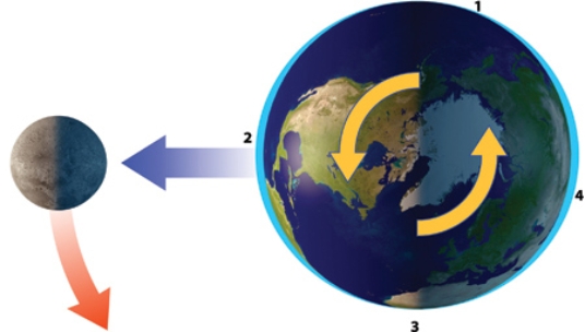
A)1
B)2
C)3
D)1 and 3
E)2 and 4
A)1
B)2
C)3
D)1 and 3
E)2 and 4
Question
With the Sun and Moon in this position, the side of the Earth facing the Moon experiences 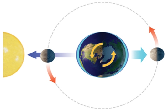
A)a normal high tide.
B)a normal low tide.
C)a spring tide.
D)a neap tide.
A)a normal high tide.
B)a normal low tide.
C)a spring tide.
D)a neap tide.
Question
Question
Question
Question
Which dashed line in this figure would be the wave base? 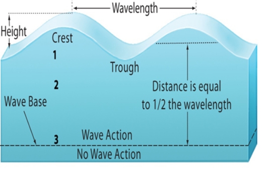
A)1
B)2
C)3
D)1 and 2
E)2 and 3
A)1
B)2
C)3
D)1 and 2
E)2 and 3
Question
How deep would the effects of this wave likely reach? 
A)only on the surface
B)1
C)2
D)3
E)much deeper than 3
A)only on the surface
B)1
C)2
D)3
E)much deeper than 3
Question
Question
Question
Question
Question
With the Sun and Moon in this position, the side of the Earth facing the Moon experiences 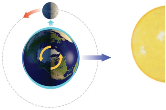
A)a normal high tide.
B)a normal low tide.
C)a spring tide.
D)a neap tide.
A)a normal high tide.
B)a normal low tide.
C)a spring tide.
D)a neap tide.
Question
Question
With the Moon in this position, which area will experience low tide? 
A)1
B)2
C)3
D)1 and 3
E)2 and 4
A)1
B)2
C)3
D)1 and 3
E)2 and 4
Question
Question
Question
Which site will most likely experience rapid erosion? 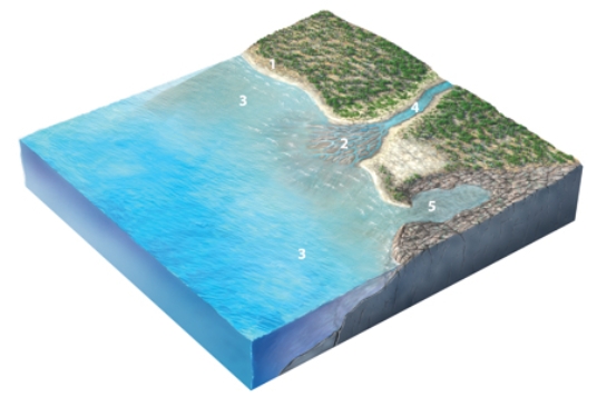
A)1, cliffs composed of hard rocks
B)2, sediments in a delta
C)3, the seafloor deep beneath the waves
D)4, the coastline of a bay
E)5, the coastline in a branching embayment
A)1, cliffs composed of hard rocks
B)2, sediments in a delta
C)3, the seafloor deep beneath the waves
D)4, the coastline of a bay
E)5, the coastline in a branching embayment
Question
This spit is a(n)_______ landform. 
A)erosional
B)depositional
C)fluvial
D)isostatic
A)erosional
B)depositional
C)fluvial
D)isostatic
Question
Question
Question
Which of the following features was not an important process contributing to the formation of Cape Cod into its present-day shape? 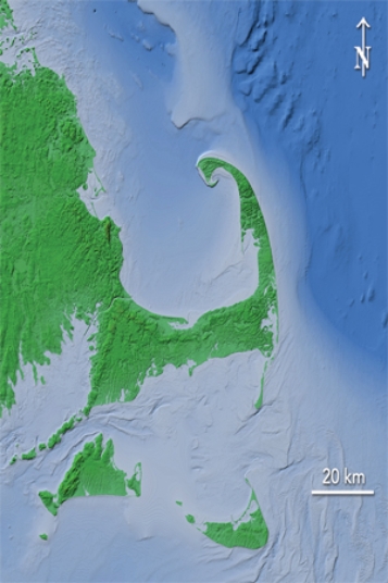
A)north to south longshore current
B)glacial deposition
C)sea level increases
D)All of these are important processes for Cape Cod's formation.
A)north to south longshore current
B)glacial deposition
C)sea level increases
D)All of these are important processes for Cape Cod's formation.
Question
Question
This wave-cut platform indicates 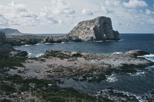
A)a rise of sea level relative to the land.
B)a lowering of sea level relative to the land.
C)movement of a large thrust fault.
D)scouring of the land surface by a tsunami.
A)a rise of sea level relative to the land.
B)a lowering of sea level relative to the land.
C)movement of a large thrust fault.
D)scouring of the land surface by a tsunami.
Question
Question
Question
Which way is the current moving along this coastline? 
A)out to sea
B)in toward the coast
C)from right to left
D)from left to right
A)out to sea
B)in toward the coast
C)from right to left
D)from left to right
Question
Question
Question
Question
Question
Question
Question
Question
What features are shown in this photograph? 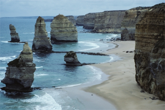
A)coral reefs
B)karst topography
C)pinnacles and sea stacks
D)sea caves
E)None of these.
A)coral reefs
B)karst topography
C)pinnacles and sea stacks
D)sea caves
E)None of these.
Question
If this spit continues to grow, cutting off the lagoon, it will become a 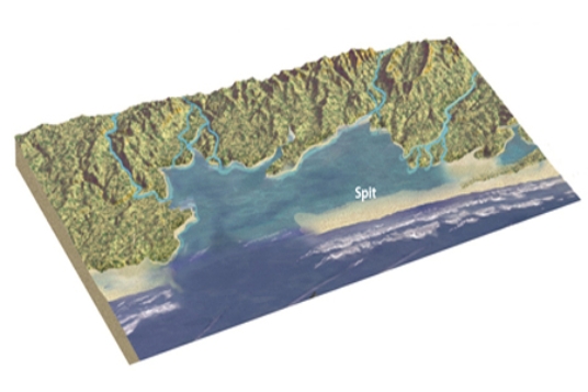
A)sandbar.
B)baymouth bar.
C)reef.
D)groin.
A)sandbar.
B)baymouth bar.
C)reef.
D)groin.
Question
The sea cave in this photograph formed by 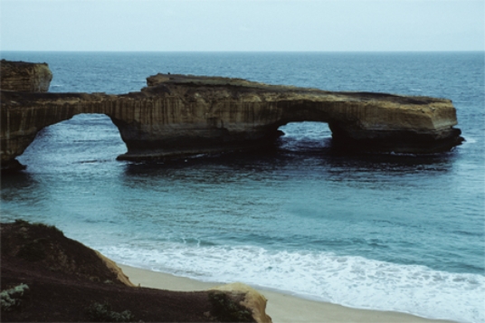
A)erosion of a promontory by waves.
B)erosion by blowing beach sand.
C)removal of rocks by giant lobsters.
D)a rapid drop in sea level.
A)erosion of a promontory by waves.
B)erosion by blowing beach sand.
C)removal of rocks by giant lobsters.
D)a rapid drop in sea level.
Question
Question
The feature pictured below formed as 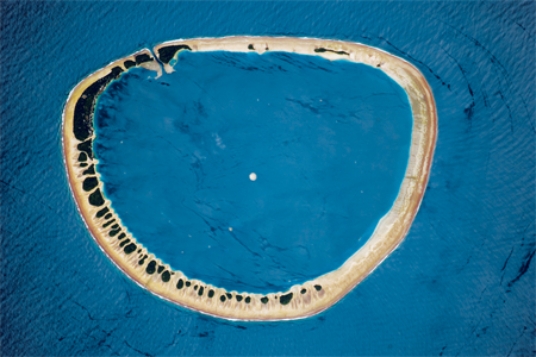
A)an island flanked by coral sank.
B)mass wasting caused the highest parts of a hill to move downslope until nothing was left in the middle.
C)oceanic sea-floor spreading occurred in a circular pattern.
D)a recent explosive volcanic eruption left only the sides of the volcano remaining.
A)an island flanked by coral sank.
B)mass wasting caused the highest parts of a hill to move downslope until nothing was left in the middle.
C)oceanic sea-floor spreading occurred in a circular pattern.
D)a recent explosive volcanic eruption left only the sides of the volcano remaining.
Question
Question
The small island on the lower right of this photograph is a(n) 
A)sea stack.
B)fringing reef.
C)atoll.
D)sandbar.
A)sea stack.
B)fringing reef.
C)atoll.
D)sandbar.
Question
Question
Question
The left to right slope of the small island on the lower right of this photograph tells us that 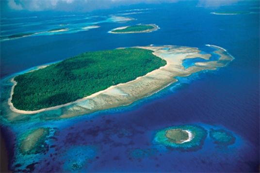
A)a nearby stream on the mainland must be providing sediment to support the island.
B)wave action must be minimal in this area.
C)an area of coastal upwelling must be nearby.
D)the ocean depth must be increasing to the right.
A)a nearby stream on the mainland must be providing sediment to support the island.
B)wave action must be minimal in this area.
C)an area of coastal upwelling must be nearby.
D)the ocean depth must be increasing to the right.
Question
Question
Question
Question
What geologic event is probably indicated by this irregular coast, with estuaries? 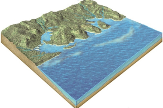
A)a rise in sea level
B)a drop in sea level
C)erosion due to large tsunamis
D)the uplift of submarine canyons
A)a rise in sea level
B)a drop in sea level
C)erosion due to large tsunamis
D)the uplift of submarine canyons
Question
Question
Question
Question
This feature is a(n) 
A)sea stack.
B)fringing reef.
C)atoll.
D)sandbar.
A)sea stack.
B)fringing reef.
C)atoll.
D)sandbar.
Question
Question
Question
An increase in the rate of seafloor spreading along this ridge would cause 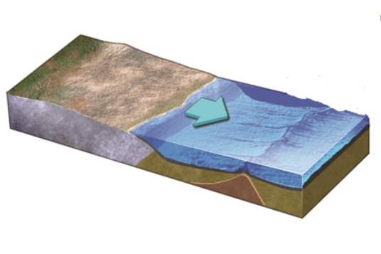
A)the ridge to become broader.
B)seawater to be displaced out of the ocean basin.
C)a rise in sea level.
D)All of these.
A)the ridge to become broader.
B)seawater to be displaced out of the ocean basin.
C)a rise in sea level.
D)All of these.
Question
Question
Question
Question
The diagram below represents which stage of the U.S.Geological Survey's model of beach erosion? 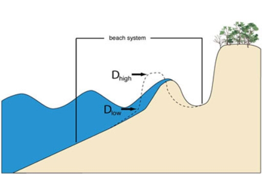
A)Swash regime
B)Collision regime
C)Overwash regime
D)Inundation regime
A)Swash regime
B)Collision regime
C)Overwash regime
D)Inundation regime
Question
Question
Question

Unlock Deck
Sign up to unlock the cards in this deck!
Unlock Deck
Unlock Deck
1/64
Play
Full screen (f)
Deck 15: Coasts and Changing Sea Levels
1
There are two high tides and two low tides in each 25-hour period because
A)Earth orbits around the Sun in a little over 24 hours.
B)the Moon orbits Earth in 25 hours.
C)Earth completes a full rotation every 24 hours but the Moon moves too.
D)heating and cooling of the seas occurs twice each day.
A)Earth orbits around the Sun in a little over 24 hours.
B)the Moon orbits Earth in 25 hours.
C)Earth completes a full rotation every 24 hours but the Moon moves too.
D)heating and cooling of the seas occurs twice each day.
C
2
The depth of wave base is the same as
A)the depth to which wave action extends.
B)a depth equal to three times the wavelength of waves.
C)the process by which waves move material along the bottom in very deep water.
D)the inside of a tubular breaking wave that is perfect for surfing.
A)the depth to which wave action extends.
B)a depth equal to three times the wavelength of waves.
C)the process by which waves move material along the bottom in very deep water.
D)the inside of a tubular breaking wave that is perfect for surfing.
A
3
With the Sun and Moon in this position, the side of the Earth facing the moon experiences
A)a normal high tide.
B)a normal low tide.
C)a spring tide.
D)a neap tide.
A)a normal high tide.
B)a normal low tide.
C)a spring tide.
D)a neap tide.
C
4
With the Moon in this position, which area will experience high tide?
A)1
B)2
C)3
D)1 and 3
E)2 and 4
A)1
B)2
C)3
D)1 and 3
E)2 and 4
Unlock Deck
Unlock for access to all 64 flashcards in this deck.
Unlock Deck
k this deck
5
With the Sun and Moon in this position, the side of the Earth facing the Moon experiences
A)a normal high tide.
B)a normal low tide.
C)a spring tide.
D)a neap tide.
A)a normal high tide.
B)a normal low tide.
C)a spring tide.
D)a neap tide.
Unlock Deck
Unlock for access to all 64 flashcards in this deck.
Unlock Deck
k this deck
6
High and low tides are caused by
A)the tendency for water on a spinning globe to be thrown outward.
B)daily heating and cooling of the seas, which causes seawater to contract and expand.
C)a rise in sea level during the day because of an increase in storms.
D)water being pulled by the gravity of the Moon.
E)All of these.
A)the tendency for water on a spinning globe to be thrown outward.
B)daily heating and cooling of the seas, which causes seawater to contract and expand.
C)a rise in sea level during the day because of an increase in storms.
D)water being pulled by the gravity of the Moon.
E)All of these.
Unlock Deck
Unlock for access to all 64 flashcards in this deck.
Unlock Deck
k this deck
7
Which of the following is true about how coasts are affected from the land side?
A)Many beach areas are backed by coastal dunes formed by the wind.
B)Rivers are not important contributors of sediment into the shoreline system.
C)Fine sediment in rivers is deposited close to shore and coarser sediment is carried farther away from shore.
D)All of these.
A)Many beach areas are backed by coastal dunes formed by the wind.
B)Rivers are not important contributors of sediment into the shoreline system.
C)Fine sediment in rivers is deposited close to shore and coarser sediment is carried farther away from shore.
D)All of these.
Unlock Deck
Unlock for access to all 64 flashcards in this deck.
Unlock Deck
k this deck
8
Which of the following is true about how coasts are affected from the water side?
A)Most waves are generated by earthquakes and become larger upon approaching the shore.
B)Most erosion along shorelines occurs from offshore currents.
C)Waves can erode, deposit, or simply transport sediment.
D)Tides increase and decrease the size of waves but leave sea level unchanged.
E)None of these.
Unlock Deck
Unlock for access to all 64 flashcards in this deck.
Unlock Deck
k this deck
9
Which dashed line in this figure would be the wave base?
A)1
B)2
C)3
D)1 and 2
E)2 and 3
A)1
B)2
C)3
D)1 and 2
E)2 and 3
Unlock Deck
Unlock for access to all 64 flashcards in this deck.
Unlock Deck
k this deck
10
How deep would the effects of this wave likely reach?
A)only on the surface
B)1
C)2
D)3
E)much deeper than 3
A)only on the surface
B)1
C)2
D)3
E)much deeper than 3
Unlock Deck
Unlock for access to all 64 flashcards in this deck.
Unlock Deck
k this deck
11
Factors that affect the appearance of a shoreline include
A)the hardness of bedrock along the coast.
B)climate and vegetation.
C)whether sea level has risen or fallen relative to the coast.
D)All of these.
A)the hardness of bedrock along the coast.
B)climate and vegetation.
C)whether sea level has risen or fallen relative to the coast.
D)All of these.
Unlock Deck
Unlock for access to all 64 flashcards in this deck.
Unlock Deck
k this deck
12
Factors that do NOT affect the appearance of a coast from the water side include
A)strength of waves and tides.
B)size and intensity of storms.
C)orientation of the coastline.
D)slope of the seafloor.
E)All of these affect the appearance.
A)strength of waves and tides.
B)size and intensity of storms.
C)orientation of the coastline.
D)slope of the seafloor.
E)All of these affect the appearance.
Unlock Deck
Unlock for access to all 64 flashcards in this deck.
Unlock Deck
k this deck
13
Climate influences the processes along coastal landscapes by
A)controlling the amount of precipitation, which affects the amount of erosion.
B)affecting the size and intensity of storms.
C)allowing wet climates to support more vegetation which may stabilize the soil.
D)melting glaciers which causes sea level to rise.
E)All of these.
A)controlling the amount of precipitation, which affects the amount of erosion.
B)affecting the size and intensity of storms.
C)allowing wet climates to support more vegetation which may stabilize the soil.
D)melting glaciers which causes sea level to rise.
E)All of these.
Unlock Deck
Unlock for access to all 64 flashcards in this deck.
Unlock Deck
k this deck
14
If waves approach the shore at an angle they
A)die out before they reach the shore.
B)begin to break in water depths deeper than the wave base.
C)bend so they approach the shore more directly.
D)do none of these because waves do not approach the shore at an angle.
A)die out before they reach the shore.
B)begin to break in water depths deeper than the wave base.
C)bend so they approach the shore more directly.
D)do none of these because waves do not approach the shore at an angle.
Unlock Deck
Unlock for access to all 64 flashcards in this deck.
Unlock Deck
k this deck
15
With the Sun and Moon in this position, the side of the Earth facing the Moon experiences
A)a normal high tide.
B)a normal low tide.
C)a spring tide.
D)a neap tide.
A)a normal high tide.
B)a normal low tide.
C)a spring tide.
D)a neap tide.
Unlock Deck
Unlock for access to all 64 flashcards in this deck.
Unlock Deck
k this deck
16
The orientation of a coastline affects the appearance of a shoreline primarily because it influences
A)the direction of prevailing winds.
B)which way river sediment enters the shoreline system.
C)the erosive effects of waves.
D)how much sun it receives.
A)the direction of prevailing winds.
B)which way river sediment enters the shoreline system.
C)the erosive effects of waves.
D)how much sun it receives.
Unlock Deck
Unlock for access to all 64 flashcards in this deck.
Unlock Deck
k this deck
17
With the Moon in this position, which area will experience low tide?
A)1
B)2
C)3
D)1 and 3
E)2 and 4
A)1
B)2
C)3
D)1 and 3
E)2 and 4
Unlock Deck
Unlock for access to all 64 flashcards in this deck.
Unlock Deck
k this deck
18
An area will experience high tide
A)in the early afternoon when water temperatures are highest.
B)when there is a quarter moon in the sky.
C)when the moon is directly overhead or on the opposite side of Earth.
D)during a period of intense sunspot activity.
A)in the early afternoon when water temperatures are highest.
B)when there is a quarter moon in the sky.
C)when the moon is directly overhead or on the opposite side of Earth.
D)during a period of intense sunspot activity.
Unlock Deck
Unlock for access to all 64 flashcards in this deck.
Unlock Deck
k this deck
19
High tides are higher than average and low tides are lower than average when
A)the Moon and the Sun are aligned relative to the Earth.
B)it is a full moon.
C)it is a new moon.
D)All of these.
A)the Moon and the Sun are aligned relative to the Earth.
B)it is a full moon.
C)it is a new moon.
D)All of these.
Unlock Deck
Unlock for access to all 64 flashcards in this deck.
Unlock Deck
k this deck
20
Which site will most likely experience rapid erosion?
A)1, cliffs composed of hard rocks
B)2, sediments in a delta
C)3, the seafloor deep beneath the waves
D)4, the coastline of a bay
E)5, the coastline in a branching embayment
A)1, cliffs composed of hard rocks
B)2, sediments in a delta
C)3, the seafloor deep beneath the waves
D)4, the coastline of a bay
E)5, the coastline in a branching embayment
Unlock Deck
Unlock for access to all 64 flashcards in this deck.
Unlock Deck
k this deck
21
This spit is a(n)_______ landform.
A)erosional
B)depositional
C)fluvial
D)isostatic
A)erosional
B)depositional
C)fluvial
D)isostatic
Unlock Deck
Unlock for access to all 64 flashcards in this deck.
Unlock Deck
k this deck
22
Which of the following features is generally composed of bedrock?
A)barrier island
B)offshore bar
C)spit
D)wave-cut platform
E)None of these.
A)barrier island
B)offshore bar
C)spit
D)wave-cut platform
E)None of these.
Unlock Deck
Unlock for access to all 64 flashcards in this deck.
Unlock Deck
k this deck
23
Rip currents form because
A)the longshore current gets intensified.
B)there is more coastal upwelling than usual.
C)neap tides bring extra energy.
D)backwash occurs in a narrow zone.
A)the longshore current gets intensified.
B)there is more coastal upwelling than usual.
C)neap tides bring extra energy.
D)backwash occurs in a narrow zone.
Unlock Deck
Unlock for access to all 64 flashcards in this deck.
Unlock Deck
k this deck
24
Which of the following features was not an important process contributing to the formation of Cape Cod into its present-day shape?
A)north to south longshore current
B)glacial deposition
C)sea level increases
D)All of these are important processes for Cape Cod's formation.
A)north to south longshore current
B)glacial deposition
C)sea level increases
D)All of these are important processes for Cape Cod's formation.
Unlock Deck
Unlock for access to all 64 flashcards in this deck.
Unlock Deck
k this deck
25
If you are caught in a rip current, the best thing to do is to
A)swim at an angle to the shore.
B)swim parallel to the shore.
C)swim perpendicular to the shore.
A)swim at an angle to the shore.
B)swim parallel to the shore.
C)swim perpendicular to the shore.
Unlock Deck
Unlock for access to all 64 flashcards in this deck.
Unlock Deck
k this deck
26
This wave-cut platform indicates
A)a rise of sea level relative to the land.
B)a lowering of sea level relative to the land.
C)movement of a large thrust fault.
D)scouring of the land surface by a tsunami.
A)a rise of sea level relative to the land.
B)a lowering of sea level relative to the land.
C)movement of a large thrust fault.
D)scouring of the land surface by a tsunami.
Unlock Deck
Unlock for access to all 64 flashcards in this deck.
Unlock Deck
k this deck
27
If multiple waves on the ocean are approaching the same point, but arriving from different directions, the result is most likely to be
A)a tsunami.
B)choppy seas.
C)smaller waves than would have occurred if the waves were coming from only one direction.
D)a shallower wave base.
A)a tsunami.
B)choppy seas.
C)smaller waves than would have occurred if the waves were coming from only one direction.
D)a shallower wave base.
Unlock Deck
Unlock for access to all 64 flashcards in this deck.
Unlock Deck
k this deck
28
How do waves propagate across the water?
A)The wave moves forward but water moves in a circular motion.
B)Water near the surface moves less than water at depth.
C)Water within the wave travels as far as the wave does.
D)All of these.
A)The wave moves forward but water moves in a circular motion.
B)Water near the surface moves less than water at depth.
C)Water within the wave travels as far as the wave does.
D)All of these.
Unlock Deck
Unlock for access to all 64 flashcards in this deck.
Unlock Deck
k this deck
29
Which way is the current moving along this coastline?
A)out to sea
B)in toward the coast
C)from right to left
D)from left to right
A)out to sea
B)in toward the coast
C)from right to left
D)from left to right
Unlock Deck
Unlock for access to all 64 flashcards in this deck.
Unlock Deck
k this deck
30
Which of the following is true about how waves form and break upon the shore?
A)Most waves form from upwelling of deep waters.
B)Waves get smaller as wind speed increases.
C)Waves begin to change when they reach water shallower than wave base.
D)Waves break in a counterclockwise direction because of rotation of the Earth.
E)None of these.
A)Most waves form from upwelling of deep waters.
B)Waves get smaller as wind speed increases.
C)Waves begin to change when they reach water shallower than wave base.
D)Waves break in a counterclockwise direction because of rotation of the Earth.
E)None of these.
Unlock Deck
Unlock for access to all 64 flashcards in this deck.
Unlock Deck
k this deck
31
In a wave of oscillation, an individual water molecule near the surface will move
A)counterclockwise in the Northern Hemisphere, clockwise in the Southern Hemisphere.
B)in a smaller vertical circle than a water molecule submerged deeper in the wave.
C)in a larger vertical circle than a water molecule submerged deeper in the wave.
D)clockwise in the Northern Hemisphere, counterclockwise in the Southern Hemisphere.
Unlock Deck
Unlock for access to all 64 flashcards in this deck.
Unlock Deck
k this deck
32
Which of the following is NOT a possible source of large stones along a shoreline?
A)waves swirl away loose pieces of bedrock
B)undercutting by waves causes steep rock faces to collapse into the sea
C)rivers depositing large cobbles near the coastline
D)large storms erode the deep seafloor and transport the rocks toward the beach
A)waves swirl away loose pieces of bedrock
B)undercutting by waves causes steep rock faces to collapse into the sea
C)rivers depositing large cobbles near the coastline
D)large storms erode the deep seafloor and transport the rocks toward the beach
Unlock Deck
Unlock for access to all 64 flashcards in this deck.
Unlock Deck
k this deck
33
The typical setting of a sea cave or sea stack is
A)within a protected bay.
B)on a barrier island.
C)on a sandbar.
D)on a baymouth bar.
E)on a promontory.
A)within a protected bay.
B)on a barrier island.
C)on a sandbar.
D)on a baymouth bar.
E)on a promontory.
Unlock Deck
Unlock for access to all 64 flashcards in this deck.
Unlock Deck
k this deck
34
Over time, a spit will grow
A)toward a promontory.
B)in the same direction as a longshore current.
C)in the direction from which waves are approaching the coast.
D)toward a wave-cut platform.
E)None of these.
A)toward a promontory.
B)in the same direction as a longshore current.
C)in the direction from which waves are approaching the coast.
D)toward a wave-cut platform.
E)None of these.
Unlock Deck
Unlock for access to all 64 flashcards in this deck.
Unlock Deck
k this deck
35
Which of the following can influence whether a coast gains or loses sand with time?
A)the amount of precipitation on land
B)the amount of sediment in rivers
C)a longshore current
D)prevailing wind direction
E)All of these.
A)the amount of precipitation on land
B)the amount of sediment in rivers
C)a longshore current
D)prevailing wind direction
E)All of these.
Unlock Deck
Unlock for access to all 64 flashcards in this deck.
Unlock Deck
k this deck
36
Sand and other sediment
A)can move laterally along the coast if waves approach the beach at an angle.
B)only move up and down the slope of the beach.
C)can slump downward if the sea bottom has too gentle a slope.
D)are moved by the wind if the material is coarser than sand.
E)All of these.
A)can move laterally along the coast if waves approach the beach at an angle.
B)only move up and down the slope of the beach.
C)can slump downward if the sea bottom has too gentle a slope.
D)are moved by the wind if the material is coarser than sand.
E)All of these.
Unlock Deck
Unlock for access to all 64 flashcards in this deck.
Unlock Deck
k this deck
37
What features are shown in this photograph?
A)coral reefs
B)karst topography
C)pinnacles and sea stacks
D)sea caves
E)None of these.
A)coral reefs
B)karst topography
C)pinnacles and sea stacks
D)sea caves
E)None of these.
Unlock Deck
Unlock for access to all 64 flashcards in this deck.
Unlock Deck
k this deck
38
If this spit continues to grow, cutting off the lagoon, it will become a
A)sandbar.
B)baymouth bar.
C)reef.
D)groin.
A)sandbar.
B)baymouth bar.
C)reef.
D)groin.
Unlock Deck
Unlock for access to all 64 flashcards in this deck.
Unlock Deck
k this deck
39
The sea cave in this photograph formed by
A)erosion of a promontory by waves.
B)erosion by blowing beach sand.
C)removal of rocks by giant lobsters.
D)a rapid drop in sea level.
A)erosion of a promontory by waves.
B)erosion by blowing beach sand.
C)removal of rocks by giant lobsters.
D)a rapid drop in sea level.
Unlock Deck
Unlock for access to all 64 flashcards in this deck.
Unlock Deck
k this deck
40
Which of the following parts of a coast is more likely to experience intense erosion?
A)a straight part of the shoreline
B)a gently curved part of the shoreline
C)areas within a bay
D)the seaward end of a promontory
A)a straight part of the shoreline
B)a gently curved part of the shoreline
C)areas within a bay
D)the seaward end of a promontory
Unlock Deck
Unlock for access to all 64 flashcards in this deck.
Unlock Deck
k this deck
41
The feature pictured below formed as
A)an island flanked by coral sank.
B)mass wasting caused the highest parts of a hill to move downslope until nothing was left in the middle.
C)oceanic sea-floor spreading occurred in a circular pattern.
D)a recent explosive volcanic eruption left only the sides of the volcano remaining.
A)an island flanked by coral sank.
B)mass wasting caused the highest parts of a hill to move downslope until nothing was left in the middle.
C)oceanic sea-floor spreading occurred in a circular pattern.
D)a recent explosive volcanic eruption left only the sides of the volcano remaining.
Unlock Deck
Unlock for access to all 64 flashcards in this deck.
Unlock Deck
k this deck
42
Which of the following would cause sea level to rise?
A)a decrease in the number of glaciers on land
B)faster rates of seafloor spreading
C)a rise in the temperature of the oceans
D)All of these.
A)a decrease in the number of glaciers on land
B)faster rates of seafloor spreading
C)a rise in the temperature of the oceans
D)All of these.
Unlock Deck
Unlock for access to all 64 flashcards in this deck.
Unlock Deck
k this deck
43
The small island on the lower right of this photograph is a(n)
A)sea stack.
B)fringing reef.
C)atoll.
D)sandbar.
A)sea stack.
B)fringing reef.
C)atoll.
D)sandbar.
Unlock Deck
Unlock for access to all 64 flashcards in this deck.
Unlock Deck
k this deck
44
What is the primary reason an increase in glaciation on land would cause sea level to fall?
A)The temperature of the oceans decreases from cold glacial streams.
B)An increase in snow cover causes the atmosphere to heat up which causes more evaporation.
C)Glaciers depress the land surface, which pulls sea level down with it.
D)Glaciers tie up large volumes of water that would otherwise be in the sea.
Unlock Deck
Unlock for access to all 64 flashcards in this deck.
Unlock Deck
k this deck
45
Which of the following most likely indicates that sea level has risen relative to the land?
A)offshore sand bars that have become coastal dunes
B)the presence of coral reefs on land
C)wave-cut notches and platforms that are above sea level
D)marine terraces
E)an irregular coastline with branching estuaries and embayments
A)offshore sand bars that have become coastal dunes
B)the presence of coral reefs on land
C)wave-cut notches and platforms that are above sea level
D)marine terraces
E)an irregular coastline with branching estuaries and embayments
Unlock Deck
Unlock for access to all 64 flashcards in this deck.
Unlock Deck
k this deck
46
The left to right slope of the small island on the lower right of this photograph tells us that
A)a nearby stream on the mainland must be providing sediment to support the island.
B)wave action must be minimal in this area.
C)an area of coastal upwelling must be nearby.
D)the ocean depth must be increasing to the right.
A)a nearby stream on the mainland must be providing sediment to support the island.
B)wave action must be minimal in this area.
C)an area of coastal upwelling must be nearby.
D)the ocean depth must be increasing to the right.
Unlock Deck
Unlock for access to all 64 flashcards in this deck.
Unlock Deck
k this deck
47
Which of the following most likely indicates that sea level has fallen relative to the land?
A)offshore sand bars that have become coastal dunes
B)the presence of coral reefs on land
C)wave-cut notches and platforms that are above sea level
D)marine terraces
E)All of these.
A)offshore sand bars that have become coastal dunes
B)the presence of coral reefs on land
C)wave-cut notches and platforms that are above sea level
D)marine terraces
E)All of these.
Unlock Deck
Unlock for access to all 64 flashcards in this deck.
Unlock Deck
k this deck
48
It has been proposed that the reason that the Pacific Ocean has many more coral reefs than the Atlantic Ocean is that
A)the Atlantic Ocean is too saline for many coral species.
B)the ocean currents in the Atlantic are too swift to allow for coral reefs to develop unimpeded.
C)the last glacial advance left the Atlantic too cold to allow coral to survive.
D)there are too many large rivers discharging polluted waters into the Atlantic basin to support as many coral reefs as in the Pacific, which is much larger and more immune to the pollution.
Unlock Deck
Unlock for access to all 64 flashcards in this deck.
Unlock Deck
k this deck
49
How does the rate of seafloor spreading affect sea level?
A)Faster spreading causes faster subduction, which pulls down continental margins.
B)Faster spreading produces broader ridges that displace water and expand the oceans.
C)Faster spreading heats up ocean waters causing them to expand and flood the land.
D)They have no effect because the rates of seafloor spreading do not change over time.
Unlock Deck
Unlock for access to all 64 flashcards in this deck.
Unlock Deck
k this deck
50
What geologic event is probably indicated by this irregular coast, with estuaries?
A)a rise in sea level
B)a drop in sea level
C)erosion due to large tsunamis
D)the uplift of submarine canyons
A)a rise in sea level
B)a drop in sea level
C)erosion due to large tsunamis
D)the uplift of submarine canyons
Unlock Deck
Unlock for access to all 64 flashcards in this deck.
Unlock Deck
k this deck
51
Which of the following is NOT an approach communities have tried to address shoreline problems?
A)construction of a seawall
B)construction of a jetty
C)lowering the local sea level
D)building a breakwater
E)replenishing sand
A)construction of a seawall
B)construction of a jetty
C)lowering the local sea level
D)building a breakwater
E)replenishing sand
Unlock Deck
Unlock for access to all 64 flashcards in this deck.
Unlock Deck
k this deck
52
What is probably the least expensive approach for avoiding shoreline hazards?
A)bringing in sand to replenish what is lost to storms
B)using private insurance money to rebuild houses destroyed by erosion and waves
C)using federal disaster money to rebuild houses destroyed by erosion and waves
D)forbidding the building of houses or other structures in high-risk areas
E)building up the land level so communities, such as New Orleans, are above sea level
Unlock Deck
Unlock for access to all 64 flashcards in this deck.
Unlock Deck
k this deck
53
What is the main way that position of the continents can influence global sea level?
A)Clustering of continents near the poles causes the planet to bulge near the equator, causing sea level to rise since more of the equatorial area is oceanic.
B)Continents near the equator receive higher amounts of rainfall.
C)Continents at high latitudes provide a setting in which large ice sheets can form.
D)Clustering of continents near the poles causes ocean temperatures to fall substantially.
Unlock Deck
Unlock for access to all 64 flashcards in this deck.
Unlock Deck
k this deck
54
This feature is a(n)
A)sea stack.
B)fringing reef.
C)atoll.
D)sandbar.
A)sea stack.
B)fringing reef.
C)atoll.
D)sandbar.
Unlock Deck
Unlock for access to all 64 flashcards in this deck.
Unlock Deck
k this deck
55
What happens to the land surface when large ice sheets melt away?
A)It subsides because there is less ice on top.
B)The land surface remains unchanged but seems lower because of the loss of ice.
C)The land flexes upward due to isostatic rebound.
D)The land rises because the rocks are warmer without the ice.
A)It subsides because there is less ice on top.
B)The land surface remains unchanged but seems lower because of the loss of ice.
C)The land flexes upward due to isostatic rebound.
D)The land rises because the rocks are warmer without the ice.
Unlock Deck
Unlock for access to all 64 flashcards in this deck.
Unlock Deck
k this deck
56
What does LIDAR data tell us about shorelines?
A)how the size of waves is related to water temperature
B)how the size of waves is related to salinity of seawater
C)changes in elevation, including destruction of houses
D)how the color of sand affects the air temperature
E)None of these.
A)how the size of waves is related to water temperature
B)how the size of waves is related to salinity of seawater
C)changes in elevation, including destruction of houses
D)how the color of sand affects the air temperature
E)None of these.
Unlock Deck
Unlock for access to all 64 flashcards in this deck.
Unlock Deck
k this deck
57
An increase in the rate of seafloor spreading along this ridge would cause
A)the ridge to become broader.
B)seawater to be displaced out of the ocean basin.
C)a rise in sea level.
D)All of these.
A)the ridge to become broader.
B)seawater to be displaced out of the ocean basin.
C)a rise in sea level.
D)All of these.
Unlock Deck
Unlock for access to all 64 flashcards in this deck.
Unlock Deck
k this deck
58
Which of the following would cause sea level to fall?
A)a decrease in the amount of glaciers on land
B)a slowing in the rate of seafloor spreading
C)a rise in the temperature of the oceans
D)All of these.
A)a decrease in the amount of glaciers on land
B)a slowing in the rate of seafloor spreading
C)a rise in the temperature of the oceans
D)All of these.
Unlock Deck
Unlock for access to all 64 flashcards in this deck.
Unlock Deck
k this deck
59
Which of the following does NOT affect the potential hazards of a shoreline?
A)elevation of the land surface near the shore
B)the distribution of hard and soft rocks
C)width of a beach
D)the presence of offshore islands and sand bars
E)All of these affect potential hazards of shorelines.
A)elevation of the land surface near the shore
B)the distribution of hard and soft rocks
C)width of a beach
D)the presence of offshore islands and sand bars
E)All of these affect potential hazards of shorelines.
Unlock Deck
Unlock for access to all 64 flashcards in this deck.
Unlock Deck
k this deck
60
What was a key point demonstrated by photographs in the textbook from before and after hurricanes?
A)Neighborhoods were flooded, but the houses and shorelines were unchanged.
B)Most houses were buried beneath sand brought in by strong waves.
C)Waves and storm surge caused erosion of beaches and destruction of houses.
D)Most houses were protected by the beach sediment.
A)Neighborhoods were flooded, but the houses and shorelines were unchanged.
B)Most houses were buried beneath sand brought in by strong waves.
C)Waves and storm surge caused erosion of beaches and destruction of houses.
D)Most houses were protected by the beach sediment.
Unlock Deck
Unlock for access to all 64 flashcards in this deck.
Unlock Deck
k this deck
61
The diagram below represents which stage of the U.S.Geological Survey's model of beach erosion?
A)Swash regime
B)Collision regime
C)Overwash regime
D)Inundation regime
A)Swash regime
B)Collision regime
C)Overwash regime
D)Inundation regime
Unlock Deck
Unlock for access to all 64 flashcards in this deck.
Unlock Deck
k this deck
62
During a hurricane or other strong coastal storm, material on barrier islands can be moved from the seaward side to the side away from the sea in the process called
A)collision.
B)overwash.
C)ebb.
D)sheet erosion.
A)collision.
B)overwash.
C)ebb.
D)sheet erosion.
Unlock Deck
Unlock for access to all 64 flashcards in this deck.
Unlock Deck
k this deck
63
Three damaging hurricanes on the U.S.Atlantic and Gulf Coasts in 2011 or 2012 were
A)Irene and Sandy on the Atlantic Coast and Ike on the Gulf Coast.
B)Irene and Sandy on the Atlantic Coast and Isaac on the Gulf Coast.
C)Imelda and Sandy on the Atlantic Coast and Ike on the Gulf Coast.
D)Imelda and Sandy on the Atlantic Coast and Isaac on the Gulf Coast.
A)Irene and Sandy on the Atlantic Coast and Ike on the Gulf Coast.
B)Irene and Sandy on the Atlantic Coast and Isaac on the Gulf Coast.
C)Imelda and Sandy on the Atlantic Coast and Ike on the Gulf Coast.
D)Imelda and Sandy on the Atlantic Coast and Isaac on the Gulf Coast.
Unlock Deck
Unlock for access to all 64 flashcards in this deck.
Unlock Deck
k this deck
64
The diagram below represents a model that the U.S.Geological Survey (USGS)uses to categorize the extent of storm surge in the coastal zone.In this diagram the Rhigh represents
A)the maximum height of the swash zone.
B)the highest rate of discharge from the nearest stream.
C)the radius of motion of water molecules that are part of the waves of oscillation.
D)the height of high tide.
A)the maximum height of the swash zone.
B)the highest rate of discharge from the nearest stream.
C)the radius of motion of water molecules that are part of the waves of oscillation.
D)the height of high tide.
Unlock Deck
Unlock for access to all 64 flashcards in this deck.
Unlock Deck
k this deck
Unlock Deck
Unlock for access to all 64 flashcards in this deck.


