Deck 13: Tectonics and Surface Relief
Full screen (f)
Question
Question
Question
Question
Question
Question
Question
Question
Question
Question
Question
Question
Question
Figure 13.4 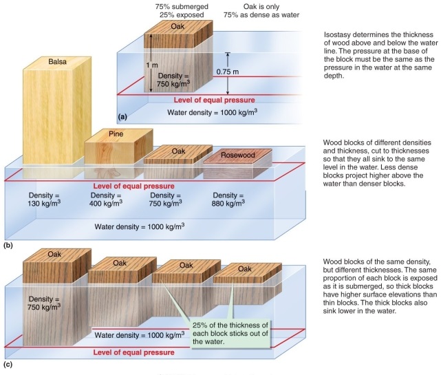
Using Figure 13.4 in your textbook, if comparing equal-weight blocks of each substance, which one would be smallest?
A) mantle
B) continental crust (mostly granite)
C) oceanic crust (mostly basalt)
D) ocean (mostly water)
Using Figure 13.4 in your textbook, if comparing equal-weight blocks of each substance, which one would be smallest?
A) mantle
B) continental crust (mostly granite)
C) oceanic crust (mostly basalt)
D) ocean (mostly water)
Question
Question
Question
Question
Question
Question
Question
Question
Question
Question
Question
Question
Question
Question
Question
Question
Question
Question
Question
Question
Question
Question
Question
Question
Question
Question
Question
Figure 13.13 
What can be determined by looking at Figure 13.14?
A) The areas of higher elevation were once buried by glaciers.
B) Areas that are now sinking under the sea once bulged up because of flexural isostasy.
C) Areas that are above sea level are growing and areas that are below sea level are sinking.
D) Eastern North America was once completely covered by glaciers.
Question
Question
Question
Question
Question
Question
Question
Question
Question
Question
Question
Question
Question
Question
Question
Question
Question
Question
Question
Question
Question
Question
Question
Question
Question
Question
Question
Question
Question
Question
Question
Question
Question
Question
Question
Question
Question
Question
Question
Question

Unlock Deck
Sign up to unlock the cards in this deck!
Unlock Deck
Unlock Deck
1/85
Play
Full screen (f)
Deck 13: Tectonics and Surface Relief
1
Compression causes
A) an increase in elevation because it forms reverse faults.
B) an increase in elevation because it shortens and thickens the lower crust.
C) a decrease in elevation because it forms reverse faults.
D) a decrease in elevation because it shortens and thickens the lower crust.
A) an increase in elevation because it forms reverse faults.
B) an increase in elevation because it shortens and thickens the lower crust.
C) a decrease in elevation because it forms reverse faults.
D) a decrease in elevation because it shortens and thickens the lower crust.
B
2
Which of the following is not an effect of tension?
A) thrust faults
B) normal faults
C) decrease in elevation
D) shrinking of mountain roots
A) thrust faults
B) normal faults
C) decrease in elevation
D) shrinking of mountain roots
A
3
What is the relief between a point where you stand in Death Valley 75 meters below sea level and the tip of a rock on a mountain 3200 meters above sea level?
A) 3125 m
B) 3200 m
C) 3950 m
D) 3275 m
A) 3125 m
B) 3200 m
C) 3950 m
D) 3275 m
A
4
What distinguishes continental crust from ocean crust?
A) elevation
B) whether or not it is covered by water
C) location
D) composition
A) elevation
B) whether or not it is covered by water
C) location
D) composition
Unlock Deck
Unlock for access to all 85 flashcards in this deck.
Unlock Deck
k this deck
5
What does the principle of isostasy explain?
A) variations in elevation due to ice pressure and weight on top of the crust
B) variations in elevation due to type and thickness of underlying crust
C) variations in elevation due to tectonic forces
D) variations in elevation due to rock age, sedimentation patterns, and oceanic history
A) variations in elevation due to ice pressure and weight on top of the crust
B) variations in elevation due to type and thickness of underlying crust
C) variations in elevation due to tectonic forces
D) variations in elevation due to rock age, sedimentation patterns, and oceanic history
Unlock Deck
Unlock for access to all 85 flashcards in this deck.
Unlock Deck
k this deck
6
The depth of the crust does not depend on
A) the height of the mountain above it.
B) the heights of nearby mountains.
C) the density of the mantle beneath it.
D) the composition of the crust.
A) the height of the mountain above it.
B) the heights of nearby mountains.
C) the density of the mantle beneath it.
D) the composition of the crust.
Unlock Deck
Unlock for access to all 85 flashcards in this deck.
Unlock Deck
k this deck
7
What geologic feature affected the accuracy of John Pratt's survey results?
A) the Nile River valley
B) the Grand Canyon (Colorado portion)
C) the Himalayan mountains
D) Ayer's Rock in Australia
A) the Nile River valley
B) the Grand Canyon (Colorado portion)
C) the Himalayan mountains
D) Ayer's Rock in Australia
Unlock Deck
Unlock for access to all 85 flashcards in this deck.
Unlock Deck
k this deck
8
What does Pratt's model of isostasy describe better than Airy's model?
A) elevation differences between oceans and continents
B) formation of rift valleys in continents
C) elevation differences within areas of continental crust
D) fault block elevations
A) elevation differences between oceans and continents
B) formation of rift valleys in continents
C) elevation differences within areas of continental crust
D) fault block elevations
Unlock Deck
Unlock for access to all 85 flashcards in this deck.
Unlock Deck
k this deck
9
Why did surveyors miscalculate latitudes in India in the 1800s?
A) gravitational deflection of plumb lines
B) inaccurate readings of stars
C) magnetic deflection of plumb lines
D) incorrect calculations with correct data
A) gravitational deflection of plumb lines
B) inaccurate readings of stars
C) magnetic deflection of plumb lines
D) incorrect calculations with correct data
Unlock Deck
Unlock for access to all 85 flashcards in this deck.
Unlock Deck
k this deck
10
If a block of balsa, pine, oak, and rosewood were each submerged into a tub of water, why would the balsa wood project higher above the water than the other blocks of wood?
A) It has a lower water content.
B) It is lighter.
C) It is a larger block.
D) It is less dense.
A) It has a lower water content.
B) It is lighter.
C) It is a larger block.
D) It is less dense.
Unlock Deck
Unlock for access to all 85 flashcards in this deck.
Unlock Deck
k this deck
11
What is the elevation of the lowest location in the United States?
A) 0 m (equal to sea level)
B) 10 m above sea level
C) 50 m below sea level
D) 85 m below sea level
A) 0 m (equal to sea level)
B) 10 m above sea level
C) 50 m below sea level
D) 85 m below sea level
Unlock Deck
Unlock for access to all 85 flashcards in this deck.
Unlock Deck
k this deck
12
What does Airy's model of isostasy describe better than Pratt's model?
A) elevation differences between oceans and continents
B) formation of rift valleys in continents
C) elevation differences within areas of continental crust
D) fault block elevations
A) elevation differences between oceans and continents
B) formation of rift valleys in continents
C) elevation differences within areas of continental crust
D) fault block elevations
Unlock Deck
Unlock for access to all 85 flashcards in this deck.
Unlock Deck
k this deck
13
Figure 13.4
Using Figure 13.4 in your textbook, if comparing equal-weight blocks of each substance, which one would be smallest?
A) mantle
B) continental crust (mostly granite)
C) oceanic crust (mostly basalt)
D) ocean (mostly water)
Using Figure 13.4 in your textbook, if comparing equal-weight blocks of each substance, which one would be smallest?
A) mantle
B) continental crust (mostly granite)
C) oceanic crust (mostly basalt)
D) ocean (mostly water)
Unlock Deck
Unlock for access to all 85 flashcards in this deck.
Unlock Deck
k this deck
14
Put the following steps in the correct sequence according to how one would take a survey reading. 1. The angle between the line sighted to the star and a line drawn directly toward Earth's center permits calculation of latitude. 2. Surveyors sight a telescope on the North Star, which is almost directly above Earth's rotation axis. 3. A table is set up with its level surface perpendicular to a line directed towards Earth's center.
A) 1, 2, 3
B) 2, 1, 3
C) 3, 2, 1
D) 3, 1, 2
A) 1, 2, 3
B) 2, 1, 3
C) 3, 2, 1
D) 3, 1, 2
Unlock Deck
Unlock for access to all 85 flashcards in this deck.
Unlock Deck
k this deck
15
How does isostasy explain the formation of rift valleys?
A) root decreases under compression
B) density decreases under tension
C) root decreases under tension
D) density decreases under compression
A) root decreases under compression
B) density decreases under tension
C) root decreases under tension
D) density decreases under compression
Unlock Deck
Unlock for access to all 85 flashcards in this deck.
Unlock Deck
k this deck
16
What is the problem with using wood-block-bathtub experiments to explain the isostasy of Earth's crust?
A) It only works for sections of Earth's crust less than 8 km thick.
B) It only works for sections of Earth's crust greater than 80 km thick.
C) Wood is not a reasonable approximation for crust behavior.
D) Bathtub water does not behave like the mantle.
A) It only works for sections of Earth's crust less than 8 km thick.
B) It only works for sections of Earth's crust greater than 80 km thick.
C) Wood is not a reasonable approximation for crust behavior.
D) Bathtub water does not behave like the mantle.
Unlock Deck
Unlock for access to all 85 flashcards in this deck.
Unlock Deck
k this deck
17
What is the ratio of sea to land on Earth?
A) 61: 39
B) 71: 29
C) 81: 19
D) 51: 49
A) 61: 39
B) 71: 29
C) 81: 19
D) 51: 49
Unlock Deck
Unlock for access to all 85 flashcards in this deck.
Unlock Deck
k this deck
18
What technology was used to determine if Airy's or Pratt's theory about mountain elevations was correct?
A) density measurements
B) seismic data
C) deep-drilling cores
D) lab analyses of composition of rock samples
A) density measurements
B) seismic data
C) deep-drilling cores
D) lab analyses of composition of rock samples
Unlock Deck
Unlock for access to all 85 flashcards in this deck.
Unlock Deck
k this deck
19
What is the main factor that determines elevation?
A) crust type
B) mantle density
C) age of rock, such as amount of erosion
D) history of rock, such as ice ages and volcanic action
A) crust type
B) mantle density
C) age of rock, such as amount of erosion
D) history of rock, such as ice ages and volcanic action
Unlock Deck
Unlock for access to all 85 flashcards in this deck.
Unlock Deck
k this deck
20
Both John Pratt and George Airy proposed a hypothesis for surface elevations in India. How was this debate settled?
A) Recalculations occurred after both men had died.
B) The Scientific Society of the time voted on it.
C) More data was gathered on account of better technology.
D) The issue has not been definitively settled.
A) Recalculations occurred after both men had died.
B) The Scientific Society of the time voted on it.
C) More data was gathered on account of better technology.
D) The issue has not been definitively settled.
Unlock Deck
Unlock for access to all 85 flashcards in this deck.
Unlock Deck
k this deck
21
Which is the best analogy for isostasy?
A) blocks of wood in water
B) a dog sleeping on a water bed
C) ice cubes in water
D) crumbling layered cookies
A) blocks of wood in water
B) a dog sleeping on a water bed
C) ice cubes in water
D) crumbling layered cookies
Unlock Deck
Unlock for access to all 85 flashcards in this deck.
Unlock Deck
k this deck
22
Which is a factor that decreases rock strength along faults?
A) age
B) weight of glaciers
C) flowing water
D) sedimentation
A) age
B) weight of glaciers
C) flowing water
D) sedimentation
Unlock Deck
Unlock for access to all 85 flashcards in this deck.
Unlock Deck
k this deck
23
The type of boundary mountains are associated with is
A) transform boundaries.
B) convergent boundaries.
C) divergent boundaries.
D) microplate boundaries.
A) transform boundaries.
B) convergent boundaries.
C) divergent boundaries.
D) microplate boundaries.
Unlock Deck
Unlock for access to all 85 flashcards in this deck.
Unlock Deck
k this deck
24
How did scientists calculate the rate of uplift of the Andes?
A) using a fossil of coral from a high rock
B) by radio-dating uplifted metamorphic rock
C) by radio-dating uplifted sedimentary rock
D) using tectonic data and knowledge of ice ages
A) using a fossil of coral from a high rock
B) by radio-dating uplifted metamorphic rock
C) by radio-dating uplifted sedimentary rock
D) using tectonic data and knowledge of ice ages
Unlock Deck
Unlock for access to all 85 flashcards in this deck.
Unlock Deck
k this deck
25
Which is not a common component of explanations for mountains?
A) sedimentation
B) plate-margin processes
C) motion in the mantle
D) vertical isostatic adjustments
A) sedimentation
B) plate-margin processes
C) motion in the mantle
D) vertical isostatic adjustments
Unlock Deck
Unlock for access to all 85 flashcards in this deck.
Unlock Deck
k this deck
26
Which of the following is not likely to have an effect on ocean depth?
A) plate tectonics
B) lava flow at mid-ocean ridges
C) lava flow at ground faults
D) age of sea floor
A) plate tectonics
B) lava flow at mid-ocean ridges
C) lava flow at ground faults
D) age of sea floor
Unlock Deck
Unlock for access to all 85 flashcards in this deck.
Unlock Deck
k this deck
27
The western United States has
A) low-density mantle that extends extraordinarily deep.
B) high-density mantle very close to the surface.
C) low-density mantle close to the surface.
D) high-density mantle that extends very deep.
A) low-density mantle that extends extraordinarily deep.
B) high-density mantle very close to the surface.
C) low-density mantle close to the surface.
D) high-density mantle that extends very deep.
Unlock Deck
Unlock for access to all 85 flashcards in this deck.
Unlock Deck
k this deck
28
If Earth's remaining glaciers melt, how would the global sea level change?
A) hardly at all; most of the water would be absorbed by porous land and by increasing size of freshwater lakes and rivers
B) the sea level would rise about 8 m
C) the sea level would rise about 80 m
D) the sea level would rise about 120 m
A) hardly at all; most of the water would be absorbed by porous land and by increasing size of freshwater lakes and rivers
B) the sea level would rise about 8 m
C) the sea level would rise about 80 m
D) the sea level would rise about 120 m
Unlock Deck
Unlock for access to all 85 flashcards in this deck.
Unlock Deck
k this deck
29
Which of the following would not be a major factor leading to weakening along faults and ultimately earthquakes?
A) glacial advance
B) glacial rebound
C) running water
D) tree roots
A) glacial advance
B) glacial rebound
C) running water
D) tree roots
Unlock Deck
Unlock for access to all 85 flashcards in this deck.
Unlock Deck
k this deck
30
An event which may have caused the oceans to become shallower was
A) the rifting apart of Pangea in the Mesozoic.
B) the repeated volcanic eruptions of the Cenozoic.
C) the earthquakes of the Paleozoic.
D) the glaciation of the Mesozoic.
A) the rifting apart of Pangea in the Mesozoic.
B) the repeated volcanic eruptions of the Cenozoic.
C) the earthquakes of the Paleozoic.
D) the glaciation of the Mesozoic.
Unlock Deck
Unlock for access to all 85 flashcards in this deck.
Unlock Deck
k this deck
31
What maximum uplift occurred on a thrust fault in Alaska during a single earthquake in 1899?
A) 25 cm
B) 1.5 m
C) 8 m
D) 15 m
A) 25 cm
B) 1.5 m
C) 8 m
D) 15 m
Unlock Deck
Unlock for access to all 85 flashcards in this deck.
Unlock Deck
k this deck
32
What is the average rate of uplift of the Andes Mountains?
A) 3.3 mm/year
B) 5 mm/year
C) 7 mm/year
D) 12 mm/year
A) 3.3 mm/year
B) 5 mm/year
C) 7 mm/year
D) 12 mm/year
Unlock Deck
Unlock for access to all 85 flashcards in this deck.
Unlock Deck
k this deck
33
Which of the following is the highest mountain range?
A) the Andes
B) the Alps
C) the Himalayas
D) the Rockies
A) the Andes
B) the Alps
C) the Himalayas
D) the Rockies
Unlock Deck
Unlock for access to all 85 flashcards in this deck.
Unlock Deck
k this deck
34
At what distance from the nearest plate boundary have the Andes formed?
A) 0-100 km
B) 100-150 km
C) 100-500 km
D) 200-400 km
A) 0-100 km
B) 100-150 km
C) 100-500 km
D) 200-400 km
Unlock Deck
Unlock for access to all 85 flashcards in this deck.
Unlock Deck
k this deck
35
Which of the following is not a factor that increases the thickness of the crust?
A) volcano growth
B) flow in lower crust
C) flexure below thrust faults
D) magmatic additions
A) volcano growth
B) flow in lower crust
C) flexure below thrust faults
D) magmatic additions
Unlock Deck
Unlock for access to all 85 flashcards in this deck.
Unlock Deck
k this deck
36
During what period did the seas evolve?
A) Cenozoic
B) Mesozoic
C) Paleozoic
D) Precambrian
A) Cenozoic
B) Mesozoic
C) Paleozoic
D) Precambrian
Unlock Deck
Unlock for access to all 85 flashcards in this deck.
Unlock Deck
k this deck
37
Which of the following is not a result of a mountain becoming too high?
A) normal faults
B) thrust faults
C) volcanism
D) melting in the mantle
A) normal faults
B) thrust faults
C) volcanism
D) melting in the mantle
Unlock Deck
Unlock for access to all 85 flashcards in this deck.
Unlock Deck
k this deck
38
Which value for the mantle is not higher than water's value?
A) density
B) viscosity
C) melting temperature
D) rate of flow
A) density
B) viscosity
C) melting temperature
D) rate of flow
Unlock Deck
Unlock for access to all 85 flashcards in this deck.
Unlock Deck
k this deck
39
As the seafloor ages, ocean depth
A) increases.
B) decreases.
C) is not affected.
D) varies.
A) increases.
B) decreases.
C) is not affected.
D) varies.
Unlock Deck
Unlock for access to all 85 flashcards in this deck.
Unlock Deck
k this deck
40
Figure 13.13
What can be determined by looking at Figure 13.14?
A) The areas of higher elevation were once buried by glaciers.
B) Areas that are now sinking under the sea once bulged up because of flexural isostasy.
C) Areas that are above sea level are growing and areas that are below sea level are sinking.
D) Eastern North America was once completely covered by glaciers.
Unlock Deck
Unlock for access to all 85 flashcards in this deck.
Unlock Deck
k this deck
41
How fast do mountains rise?
A) 3 to 10 mm per year
B) 1 to 10 cm per year
C) 1.5 cm per year
D) As fast as finger nail growth.
A) 3 to 10 mm per year
B) 1 to 10 cm per year
C) 1.5 cm per year
D) As fast as finger nail growth.
Unlock Deck
Unlock for access to all 85 flashcards in this deck.
Unlock Deck
k this deck
42
The Precambrian Crust is
A) metamorphic and plutonic rock.
B) plutonic and sedimentary rock.
C) sedimentary, metamorphic, and plutonic rock.
D) metamorphic and sedimentary rock.
A) metamorphic and plutonic rock.
B) plutonic and sedimentary rock.
C) sedimentary, metamorphic, and plutonic rock.
D) metamorphic and sedimentary rock.
Unlock Deck
Unlock for access to all 85 flashcards in this deck.
Unlock Deck
k this deck
43
Which of the following statements about cratons is not true?
A) They have been tectonically stable for more than 500 million years.
B) They are usually less than a half of a kilometer above sea level.
C) They are exterior regions of continents.
D) They may be broken by faults.
A) They have been tectonically stable for more than 500 million years.
B) They are usually less than a half of a kilometer above sea level.
C) They are exterior regions of continents.
D) They may be broken by faults.
Unlock Deck
Unlock for access to all 85 flashcards in this deck.
Unlock Deck
k this deck
44
Read carefully through the paragraph below, and decide which of the options is correct. The principle of isostasy explains variations in surface elevations in terms of the type and thickness of underlying crust. Low-density crust floats on denser, underlying mantle so that the temperature is everywhere the same at the base of any thick vertical column through the crust and upper mantle.
A) The word " isostasy" should be replaced by "superposition."
B) The word " elevations " should be replaced by "pressures."
C) The word "temperature" should be replaced by " pressure ."
D) The words " underlying crust " should be replaced by " underlying mantle."
A) The word " isostasy" should be replaced by "superposition."
B) The word " elevations " should be replaced by "pressures."
C) The word "temperature" should be replaced by " pressure ."
D) The words " underlying crust " should be replaced by " underlying mantle."
Unlock Deck
Unlock for access to all 85 flashcards in this deck.
Unlock Deck
k this deck
45
How was the Coast Range in Oregon and Washington formed?
A) thrust and uplift of continental crust
B) accretion by subduction zones
C) as a volcanic island arc
D) sea mounts and island volcanoes
A) thrust and uplift of continental crust
B) accretion by subduction zones
C) as a volcanic island arc
D) sea mounts and island volcanoes
Unlock Deck
Unlock for access to all 85 flashcards in this deck.
Unlock Deck
k this deck
46
Why is the west coast of North America 500 km west of where it was about 540 million years ago?
A) plate movement
B) accretion of exotic terrains
C) thrust and uplift of continental crust
D) volcanic eruptions
A) plate movement
B) accretion of exotic terrains
C) thrust and uplift of continental crust
D) volcanic eruptions
Unlock Deck
Unlock for access to all 85 flashcards in this deck.
Unlock Deck
k this deck
47
Which of the following present-day observations of crustal movement in formerly ice covered regions of North America and Eurasia support the flexural isostasy hypothesis?
A) Originally depressed areas rose to their original position by the time the ice finished melting.
B) Originally depressed areas are still rising and the bulges are stationary.
C) Originally depressed areas are still rising and the bulges are sinking.
D) Originally depressed areas are sinking and the bulges are rising.
Unlock Deck
Unlock for access to all 85 flashcards in this deck.
Unlock Deck
k this deck
48
How old is the Precambrian Crust?
A) 0-500 million years
B) 500 million-1 billion years
C) 500 million-1.5 billion years
D) 1 billion-4 billion years
A) 0-500 million years
B) 500 million-1 billion years
C) 500 million-1.5 billion years
D) 1 billion-4 billion years
Unlock Deck
Unlock for access to all 85 flashcards in this deck.
Unlock Deck
k this deck
49
Although George Airy's hypothesis better explains surveying errors in the Himalayas, John Pratt's hypothesis better explains
A) how the Himalayas formed in the first place.
B) elevation differences between oceans and continents.
C) surveying errors in the Appalachian Mountains.
D) isostatic adjustments to ice-age glaciers.
A) how the Himalayas formed in the first place.
B) elevation differences between oceans and continents.
C) surveying errors in the Appalachian Mountains.
D) isostatic adjustments to ice-age glaciers.
Unlock Deck
Unlock for access to all 85 flashcards in this deck.
Unlock Deck
k this deck
50
The Precambrian basement rocks of the Upper Peninsula of Michigan became part of the North American continent
A) more than 2.5 billion years ago.
B) 1.9 billion years ago.
C) 1.8 to 1.9 billion years ago.
D) 1.7 to 1.8 billion years ago.
E) about 1.1 billion years ago.
A) more than 2.5 billion years ago.
B) 1.9 billion years ago.
C) 1.8 to 1.9 billion years ago.
D) 1.7 to 1.8 billion years ago.
E) about 1.1 billion years ago.
Unlock Deck
Unlock for access to all 85 flashcards in this deck.
Unlock Deck
k this deck
51
How were the Appalachian Mountains formed?
A) thrust and uplift of continental crust
B) accretion by subduction zones
C) as a volcanic island arc
D) sea mounts and island volcanoes
A) thrust and uplift of continental crust
B) accretion by subduction zones
C) as a volcanic island arc
D) sea mounts and island volcanoes
Unlock Deck
Unlock for access to all 85 flashcards in this deck.
Unlock Deck
k this deck
52
The principle of isostasy tells us that the key factor(s) determining the elevation of a floating object is(are)
A) thickness and density.
B) thickness only.
C) density only.
D) the percentage of ice.
A) thickness and density.
B) thickness only.
C) density only.
D) the percentage of ice.
Unlock Deck
Unlock for access to all 85 flashcards in this deck.
Unlock Deck
k this deck
53
Which of the following surface elevations is clearly underlain by oceanic crust?
A) 8.85 km
B) 0 km (sea level)
C) - 0.5 km
D) - 5 km
A) 8.85 km
B) 0 km (sea level)
C) - 0.5 km
D) - 5 km
Unlock Deck
Unlock for access to all 85 flashcards in this deck.
Unlock Deck
k this deck
54
The elevations of continents and oceans vary from each other because
A) oceanic crust is thinner and denser than continental crust.
B) oceanic crust is thinner and less dense than continental crust.
C) oceanic crust is thicker and denser than continental crust.
D) oceanic crust is thicker and less dense than continental crust.
A) oceanic crust is thinner and denser than continental crust.
B) oceanic crust is thinner and less dense than continental crust.
C) oceanic crust is thicker and denser than continental crust.
D) oceanic crust is thicker and less dense than continental crust.
Unlock Deck
Unlock for access to all 85 flashcards in this deck.
Unlock Deck
k this deck
55
The stresses responsible for present-day earthquakes in northeastern North America are a result of
A) ancient fault movements.
B) tectonic convergence.
C) tectonic divergence.
D) glacial rebound.
A) ancient fault movements.
B) tectonic convergence.
C) tectonic divergence.
D) glacial rebound.
Unlock Deck
Unlock for access to all 85 flashcards in this deck.
Unlock Deck
k this deck
56
All past changes in sea level were due to the growth and demise of glaciers.
Unlock Deck
Unlock for access to all 85 flashcards in this deck.
Unlock Deck
k this deck
57
According to Figure 13.29, where did the oldest crust in North America form?
A) in northern Canada
B) in southern Mexico
C) in the Western Cordillera
D) on the east side of the continent
A) in northern Canada
B) in southern Mexico
C) in the Western Cordillera
D) on the east side of the continent
Unlock Deck
Unlock for access to all 85 flashcards in this deck.
Unlock Deck
k this deck
58
Continents are the product of mountain building at ancient ________ boundaries.
A) transform
B) divergent
C) convergent
D) decorticate
A) transform
B) divergent
C) convergent
D) decorticate
Unlock Deck
Unlock for access to all 85 flashcards in this deck.
Unlock Deck
k this deck
59
The Precambrian basement rocks of Ohio became part of the North American continent
A) more than 2.5 billion years ago.
B) 1.9 billion years ago.
C) 1.8 to 1.9 billion years ago.
D) 1.7 to 1.8 billion years ago.
E) about 1.1 billion years ago.
A) more than 2.5 billion years ago.
B) 1.9 billion years ago.
C) 1.8 to 1.9 billion years ago.
D) 1.7 to 1.8 billion years ago.
E) about 1.1 billion years ago.
Unlock Deck
Unlock for access to all 85 flashcards in this deck.
Unlock Deck
k this deck
60
Rocks greater than 2.5 billion years old were formed by
A) volcanic arcs at mid-ocean ridges.
B) volcanic arcs at convergent boundaries.
C) uplift of crust.
D) collision of tectonic plates.
A) volcanic arcs at mid-ocean ridges.
B) volcanic arcs at convergent boundaries.
C) uplift of crust.
D) collision of tectonic plates.
Unlock Deck
Unlock for access to all 85 flashcards in this deck.
Unlock Deck
k this deck
61
How could there be fossils of marine organisms at the tops of mountains?
Unlock Deck
Unlock for access to all 85 flashcards in this deck.
Unlock Deck
k this deck
62
How could the Himalayan Mountains be getting taller?
Unlock Deck
Unlock for access to all 85 flashcards in this deck.
Unlock Deck
k this deck
63
What is GPS and what does it do?
Unlock Deck
Unlock for access to all 85 flashcards in this deck.
Unlock Deck
k this deck
64
The ________ is an example of isostatic adjustment causing an earthquake.
A) San Andreas Fault
B) north slope of Alaska
C) New Madrid region
D) great tsunami of December 2004
A) San Andreas Fault
B) north slope of Alaska
C) New Madrid region
D) great tsunami of December 2004
Unlock Deck
Unlock for access to all 85 flashcards in this deck.
Unlock Deck
k this deck
65
Read carefully through the following sentence, and decide which of the options is correct. Erosion and deposition of sediment redistribute mass and change the densities of columns of crust.
A) The word "sediment" should be replaced by "magma."
B) The word "crust" should be replaced by "mantle."
C) The word " mass" should be replaced by "temperature."
D) The word "densities" should be replaced by " thickness."
A) The word "sediment" should be replaced by "magma."
B) The word "crust" should be replaced by "mantle."
C) The word " mass" should be replaced by "temperature."
D) The word "densities" should be replaced by " thickness."
Unlock Deck
Unlock for access to all 85 flashcards in this deck.
Unlock Deck
k this deck
66
What are sea cliffs evidence of?
Unlock Deck
Unlock for access to all 85 flashcards in this deck.
Unlock Deck
k this deck
67
What two limitations do the wood-block analogies of Earth-scale isostasy have?
Unlock Deck
Unlock for access to all 85 flashcards in this deck.
Unlock Deck
k this deck
68
How does isostasy relate to active geologic processes?
Unlock Deck
Unlock for access to all 85 flashcards in this deck.
Unlock Deck
k this deck
69
Which of the following correctly states the connection between lithosphere age and water depth?
A) An older average lithosphere age corresponds with higher sea levels.
B) An younger average lithosphere age corresponds with lower sea levels.
C) An younger average lithosphere age corresponds with higher sea levels.
D) There is no connection between average lithosphere age and sea level.
A) An older average lithosphere age corresponds with higher sea levels.
B) An younger average lithosphere age corresponds with lower sea levels.
C) An younger average lithosphere age corresponds with higher sea levels.
D) There is no connection between average lithosphere age and sea level.
Unlock Deck
Unlock for access to all 85 flashcards in this deck.
Unlock Deck
k this deck
70
Areas of oceanic crust tend to stand at ________ than do areas of continental crust.
A) lower elevations above the mantle
B) higher elevations above the mantle
C) lower elevations below the mantle
D) higher elevations below the mantle
A) lower elevations above the mantle
B) higher elevations above the mantle
C) lower elevations below the mantle
D) higher elevations below the mantle
Unlock Deck
Unlock for access to all 85 flashcards in this deck.
Unlock Deck
k this deck
71
Read carefully through the following sentence, and decide which of the options is correct. Most mountain belts form near convergent plate boundaries where crust thickens by tensional shortening and by intrusion and crystallization of magma.
A) The word "tensional" should be replaced by "compressional."
B) The word "convergent " should be replaced by "divergent."
C) The word "near" should be replaced by "far from."
D) The word "crust" should be replaced by "mantle."
A) The word "tensional" should be replaced by "compressional."
B) The word "convergent " should be replaced by "divergent."
C) The word "near" should be replaced by "far from."
D) The word "crust" should be replaced by "mantle."
Unlock Deck
Unlock for access to all 85 flashcards in this deck.
Unlock Deck
k this deck
72
Oceanic crust is ________ than continental crust.
A) less dense and thicker
B) less dense and thinner
C) more dense and thicker
D) more dense and thinner
A) less dense and thicker
B) less dense and thinner
C) more dense and thicker
D) more dense and thinner
Unlock Deck
Unlock for access to all 85 flashcards in this deck.
Unlock Deck
k this deck
73
Far-western North America contains a variety of fault bounded crustal blocks called ________ terranes.
A) accreted
B) island arc
C) seamount
D) ridge
A) accreted
B) island arc
C) seamount
D) ridge
Unlock Deck
Unlock for access to all 85 flashcards in this deck.
Unlock Deck
k this deck
74
A model for Earth elevation based only on oceanic crust being denser than continental crust results in
A) continental crust being too thick.
B) oceanic crust being too thick.
C) continental and oceanic crust being too thick.
D) reasonable estimates of crustal thickness and crustal densities.
A) continental crust being too thick.
B) oceanic crust being too thick.
C) continental and oceanic crust being too thick.
D) reasonable estimates of crustal thickness and crustal densities.
Unlock Deck
Unlock for access to all 85 flashcards in this deck.
Unlock Deck
k this deck
75
Judge the following sentence according to the criteria given below. Mountains continue to rise long after tectonic forces cease to thicken crust and drive uplift along faults because mountains result both from tectonic deformation and isostatic response to erosion.
A) The assertion and the reason are both correct, and the reason is valid.
B) The assertion and the reason are both correct, but the reason is invalid.
C) The assertion is correct but the reason is incorrect.
D) The assertion is incorrect but the reason is correct.
E) Both the assertion and the reason are incorrect.
Unlock Deck
Unlock for access to all 85 flashcards in this deck.
Unlock Deck
k this deck
76
How can surface uplift happen without forming mountains?
Unlock Deck
Unlock for access to all 85 flashcards in this deck.
Unlock Deck
k this deck
77
The principle of isostasy emerged in the nineteenth century to explain puzzling survey measurements near
A) the Himalayas.
B) Africa.
C) the Alps.
D) England.
A) the Himalayas.
B) Africa.
C) the Alps.
D) England.
Unlock Deck
Unlock for access to all 85 flashcards in this deck.
Unlock Deck
k this deck
78
A model for Earth elevation based only on oceanic crust being thinner than continental crust results in
A) oceanic crust being denser than continental crust.
B) continental crust being denser than oceanic crust.
C) continental crust and oceanic crust having the same densities.
D) reasonable estimates of crustal thickness and crustal densities.
A) oceanic crust being denser than continental crust.
B) continental crust being denser than oceanic crust.
C) continental crust and oceanic crust having the same densities.
D) reasonable estimates of crustal thickness and crustal densities.
Unlock Deck
Unlock for access to all 85 flashcards in this deck.
Unlock Deck
k this deck
79
A model for Earth elevation based on oceanic crust being thinner than continental crust and oceanic crust being denser than continental crust results in
A) continental crust and oceanic crust having the same densities.
B) continental and oceanic crust being too thick.
C) continental crust being denser than oceanic crust.
D) reasonable estimates of crustal thickness and crustal densities.
A) continental crust and oceanic crust having the same densities.
B) continental and oceanic crust being too thick.
C) continental crust being denser than oceanic crust.
D) reasonable estimates of crustal thickness and crustal densities.
Unlock Deck
Unlock for access to all 85 flashcards in this deck.
Unlock Deck
k this deck
80
Which of the following statements regarding sea-level is false?
A) Sea level is a convenient reference position because it is constant.
B) The edges of continents submerged today were dry land at times in the past.
C) Marine sedimentary rocks in present day continental interiors indicate times when continents were submerged.
D) There is a connection between average lithosphere age and sea level.
Unlock Deck
Unlock for access to all 85 flashcards in this deck.
Unlock Deck
k this deck
Unlock Deck
Unlock for access to all 85 flashcards in this deck.


