Deck 1: Major Geographic Concepts
Full screen (f)
Question
Question
Question
Question
Question
The map of Afghanistan and Pakistan best correlates which two themes? 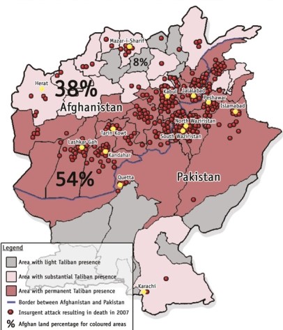
A)The relationship between Hindus and Muslims.
B)The relationship between Taliban people and insurgent attacks.
C)The dependence of Afghans on poppy production for heroin.
D)The intensity of Pakistan's friendliness with the Afghans.
A)The relationship between Hindus and Muslims.
B)The relationship between Taliban people and insurgent attacks.
C)The dependence of Afghans on poppy production for heroin.
D)The intensity of Pakistan's friendliness with the Afghans.
Question
Question
Covariation, as seen in the two maps, is described as 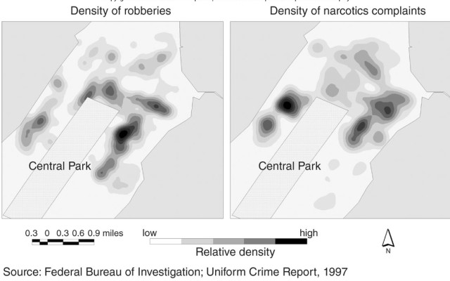
A)how a spatial pattern varies through space on a map.
B)how two similar mapped patterns can be compared to help explain a phenomenon.
C)how a choropleth map divides its data into classes for easier understanding.
D)how isoline maps portray continuous data.
A)how a spatial pattern varies through space on a map.
B)how two similar mapped patterns can be compared to help explain a phenomenon.
C)how a choropleth map divides its data into classes for easier understanding.
D)how isoline maps portray continuous data.
Question
Question
Question
In this figure, the principle of place similarity is shown where 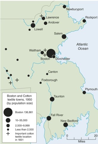
A)all textile manufacturers are located in the city of Boston.
B)all textile manufacturers are located near the shoreline of the Atlantic.
C)all textile manufacturers are located at a stream or water source.
D)all textile manufacturers are located near automobile factories.
A)all textile manufacturers are located in the city of Boston.
B)all textile manufacturers are located near the shoreline of the Atlantic.
C)all textile manufacturers are located at a stream or water source.
D)all textile manufacturers are located near automobile factories.
Question
Question
Question
Question
Question
A map of the type shown where numerically classed shaded areas display patterns is called 
A)a contour map.
B)an isoline map.
C)a choropleth map.
D)a cartogram.
A)a contour map.
B)an isoline map.
C)a choropleth map.
D)a cartogram.
Question
Question
For this map we might say the pattern observed is 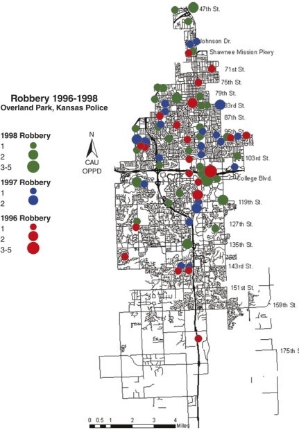
A)rather linear in form.
B)rather dispersed in form.
C)rather clustered in form.
D)rather square in form.
A)rather linear in form.
B)rather dispersed in form.
C)rather clustered in form.
D)rather square in form.
Question
Question
Question
The shades representing patterns on the political maps are 
A)almost exactly the same.
B)very similar with significant differences.
C)reversed.
D)not colored at all alike.
A)almost exactly the same.
B)very similar with significant differences.
C)reversed.
D)not colored at all alike.
Question
Question
If the figure shown is a good example then the best tool for analyzing landscapes might be 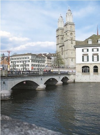
A)a map.
B)a pie chart.
C)a photograph.
D)an equation.
A)a map.
B)a pie chart.
C)a photograph.
D)an equation.
Question
Question
Question
The line maps of travel times across the U.S.during two time periods show that 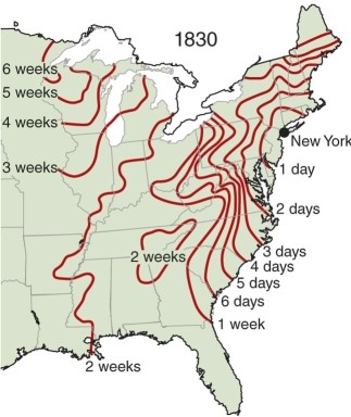
A)It took about the same amount of time to travel to California in both time periods from New York City.
B)New York to Ohio took 1 week in 1830 whereas in 1857 it only took 1 day.
C)It only took two weeks to travel to Alaska in 1830 while it took 1 week in 1857.
D)such maps are not useful for showing travel times.
Question
Question
Question
In the figure, what common criteria for a formal (uniform) region links all the areas colored in orange? 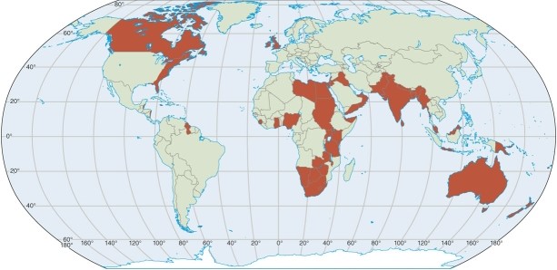
A)all are developed and industrialized areas.
B)all are agricultural areas with little industry.
C)all have common tastes in diet-mainly being influenced by the Mediterranean.
D)all are former British colonies or having significant British influence.
A)all are developed and industrialized areas.
B)all are agricultural areas with little industry.
C)all have common tastes in diet-mainly being influenced by the Mediterranean.
D)all are former British colonies or having significant British influence.
Question
Question
Though the map of country music stations shows patterns using dots for individual stations, one can surmise from this map that a country music region might be located mainly in 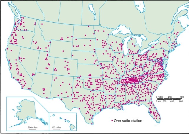
A)Nevada.
B)Tennessee.
C)Georgia.
D)South Carolina.
A)Nevada.
B)Tennessee.
C)Georgia.
D)South Carolina.
Question
In the 2008 election map, coastal areas tend to 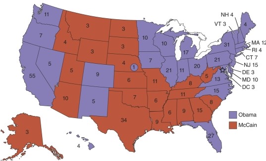
A)exhibit more democratic traits.
B)favor McCain.
C)be mixed in party preferences.
D)show no discernible pattern, politically.
A)exhibit more democratic traits.
B)favor McCain.
C)be mixed in party preferences.
D)show no discernible pattern, politically.
Question
Question
Question
Question
Question
Question
In considering movement of commuters in central city and metropolitan suburbs within the figure, which has the highest percentage of type? 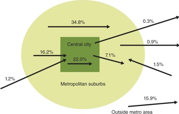
A)movement through metropolitan suburbs
B)movement from central city to suburbs
C)movement from suburbs to central city
D)movement through the central city.
A)movement through metropolitan suburbs
B)movement from central city to suburbs
C)movement from suburbs to central city
D)movement through the central city.
Question
Question
Question

Unlock Deck
Sign up to unlock the cards in this deck!
Unlock Deck
Unlock Deck
1/40
Play
Full screen (f)
Deck 1: Major Geographic Concepts
1
Every line of longitude is called:
A)a meridian.
B)a parallel.
C)a prime meridian.
D)an equator.
A)a meridian.
B)a parallel.
C)a prime meridian.
D)an equator.
A.
2
Which of the following is the best example of absolute distance?
A)It costs me $5.00 to get to work daily.
B)It takes me 15 minutes to drive to the mall.
C)It is 5 miles to my aunt's house.
D)My ancestors came from somewhere an ocean away.
A)It costs me $5.00 to get to work daily.
B)It takes me 15 minutes to drive to the mall.
C)It is 5 miles to my aunt's house.
D)My ancestors came from somewhere an ocean away.
C.
3
'Sense of place' is understanding that, for their observers, the places
A)have many meanings.
B)are very abstract.
C)are best experienced blindfolded.
D)bring many push-pull factors to a spatial relationship.
A)have many meanings.
B)are very abstract.
C)are best experienced blindfolded.
D)bring many push-pull factors to a spatial relationship.
A.
4
Which of the following is true regarding how geographers interpret space?
A)An analysis of how believers use the inside of a Church or sacred structure.
B)A measure of the distance between Church A and Church B.
C)Understanding a formal (uniform) region of French language usage.
D)The interaction of a farmer with the land, weather, and climate on the farm.
A)An analysis of how believers use the inside of a Church or sacred structure.
B)A measure of the distance between Church A and Church B.
C)Understanding a formal (uniform) region of French language usage.
D)The interaction of a farmer with the land, weather, and climate on the farm.
Unlock Deck
Unlock for access to all 40 flashcards in this deck.
Unlock Deck
k this deck
5
The map of Afghanistan and Pakistan best correlates which two themes?
A)The relationship between Hindus and Muslims.
B)The relationship between Taliban people and insurgent attacks.
C)The dependence of Afghans on poppy production for heroin.
D)The intensity of Pakistan's friendliness with the Afghans.
A)The relationship between Hindus and Muslims.
B)The relationship between Taliban people and insurgent attacks.
C)The dependence of Afghans on poppy production for heroin.
D)The intensity of Pakistan's friendliness with the Afghans.
Unlock Deck
Unlock for access to all 40 flashcards in this deck.
Unlock Deck
k this deck
6
To what maximum extent is latitude measured?
A)To 180 degrees east or west (half way around the earth's surface).
B)To 90 degrees north or south (as a right angle to a pole).
C)To 360 degrees in any direction (which completes a circle).
D)To 45 degree north or south (half way to a pole).
A)To 180 degrees east or west (half way around the earth's surface).
B)To 90 degrees north or south (as a right angle to a pole).
C)To 360 degrees in any direction (which completes a circle).
D)To 45 degree north or south (half way to a pole).
Unlock Deck
Unlock for access to all 40 flashcards in this deck.
Unlock Deck
k this deck
7
Covariation, as seen in the two maps, is described as
A)how a spatial pattern varies through space on a map.
B)how two similar mapped patterns can be compared to help explain a phenomenon.
C)how a choropleth map divides its data into classes for easier understanding.
D)how isoline maps portray continuous data.
A)how a spatial pattern varies through space on a map.
B)how two similar mapped patterns can be compared to help explain a phenomenon.
C)how a choropleth map divides its data into classes for easier understanding.
D)how isoline maps portray continuous data.
Unlock Deck
Unlock for access to all 40 flashcards in this deck.
Unlock Deck
k this deck
8
Place is different from space in that
A)Place is abstract and space is more tangible.
B)Space is more abstract and place is more tangible.
C)Both mean about the same thing to geographers.
D)Neither is applicable to geographical studies.
A)Place is abstract and space is more tangible.
B)Space is more abstract and place is more tangible.
C)Both mean about the same thing to geographers.
D)Neither is applicable to geographical studies.
Unlock Deck
Unlock for access to all 40 flashcards in this deck.
Unlock Deck
k this deck
9
Geographers call how phenomena are arranged in space
A)Spatial theory.
B)Place interaction.
C)Distance learning.
D)Distribution.
A)Spatial theory.
B)Place interaction.
C)Distance learning.
D)Distribution.
Unlock Deck
Unlock for access to all 40 flashcards in this deck.
Unlock Deck
k this deck
10
In this figure, the principle of place similarity is shown where
A)all textile manufacturers are located in the city of Boston.
B)all textile manufacturers are located near the shoreline of the Atlantic.
C)all textile manufacturers are located at a stream or water source.
D)all textile manufacturers are located near automobile factories.
A)all textile manufacturers are located in the city of Boston.
B)all textile manufacturers are located near the shoreline of the Atlantic.
C)all textile manufacturers are located at a stream or water source.
D)all textile manufacturers are located near automobile factories.
Unlock Deck
Unlock for access to all 40 flashcards in this deck.
Unlock Deck
k this deck
11
An example of a cognate discipline to geography might be
A)sociology, since sociologists are sometimes interested in mapping behavior.
B)geology, since both geologist and physical geographers might be interested in landforms.
C)political science, since political scientists often map and understand electoral and other political patterns spatially.
D)all of the above would be cognate disciplines. Scrambling: Locked
Unlock Deck
Unlock for access to all 40 flashcards in this deck.
Unlock Deck
k this deck
12
To say a pattern is random is to say
A)that there is usually a circular pattern of points.
B)that points or items are likely to be lined up in rows.
C)that there is no identifiable design or form to the distribution.
D)that the spatial proxies are contained within centrally located cumulative points.
A)that there is usually a circular pattern of points.
B)that points or items are likely to be lined up in rows.
C)that there is no identifiable design or form to the distribution.
D)that the spatial proxies are contained within centrally located cumulative points.
Unlock Deck
Unlock for access to all 40 flashcards in this deck.
Unlock Deck
k this deck
13
The difference between absolute and relative location might be:
A)and
A)the explanations for relative location are multivariate.
B)absolute location leads the map reader to one designated place.
C)both a.and b.are correct.
D)there is no significant difference between absolute and relative location.
A)and
A)the explanations for relative location are multivariate.
B)absolute location leads the map reader to one designated place.
C)both a.and b.are correct.
D)there is no significant difference between absolute and relative location.
Unlock Deck
Unlock for access to all 40 flashcards in this deck.
Unlock Deck
k this deck
14
A site is the immediate environment of a place while situation deals with
A)the general surroundings of a place.
B)the rock beneath the place.
C)cultural diffusion.
D)Euclidean space.
A)the general surroundings of a place.
B)the rock beneath the place.
C)cultural diffusion.
D)Euclidean space.
Unlock Deck
Unlock for access to all 40 flashcards in this deck.
Unlock Deck
k this deck
15
A map of the type shown where numerically classed shaded areas display patterns is called
A)a contour map.
B)an isoline map.
C)a choropleth map.
D)a cartogram.
A)a contour map.
B)an isoline map.
C)a choropleth map.
D)a cartogram.
Unlock Deck
Unlock for access to all 40 flashcards in this deck.
Unlock Deck
k this deck
16
Geographers often look at processes, meaning how patterns became the way they are.If processes have multivariate explanations, then:
A)and
A)there are many factors which help explain the phenomenon.
B)there is probably only one factor that mainly explains the phenomenon.
C)both a.and b.
D)none of the above.
A)and
A)there are many factors which help explain the phenomenon.
B)there is probably only one factor that mainly explains the phenomenon.
C)both a.and b.
D)none of the above.
Unlock Deck
Unlock for access to all 40 flashcards in this deck.
Unlock Deck
k this deck
17
For this map we might say the pattern observed is
A)rather linear in form.
B)rather dispersed in form.
C)rather clustered in form.
D)rather square in form.
A)rather linear in form.
B)rather dispersed in form.
C)rather clustered in form.
D)rather square in form.
Unlock Deck
Unlock for access to all 40 flashcards in this deck.
Unlock Deck
k this deck
18
Which of the following does not apply to the concept of process?
A)When something starts and when something ends.
B)If some phenomena has a logical progression.
C)When you can't access the appropriate webpage in your browser.
D)Explanations of why process has occurred.
A)When something starts and when something ends.
B)If some phenomena has a logical progression.
C)When you can't access the appropriate webpage in your browser.
D)Explanations of why process has occurred.
Unlock Deck
Unlock for access to all 40 flashcards in this deck.
Unlock Deck
k this deck
19
In considering spatial interactions between places, which of the following is a salient characteristic?
A)region
B)clustering
C)direction
D)distance
A)region
B)clustering
C)direction
D)distance
Unlock Deck
Unlock for access to all 40 flashcards in this deck.
Unlock Deck
k this deck
20
The shades representing patterns on the political maps are
A)almost exactly the same.
B)very similar with significant differences.
C)reversed.
D)not colored at all alike.
A)almost exactly the same.
B)very similar with significant differences.
C)reversed.
D)not colored at all alike.
Unlock Deck
Unlock for access to all 40 flashcards in this deck.
Unlock Deck
k this deck
21
A geographical coordinate system on the Earth sphere is called
A)The United States Public Land System.
B)Latitude and longitude.
C)The Universal Transverse Mercator system.
D)The plane coordinate system in feet.
A)The United States Public Land System.
B)Latitude and longitude.
C)The Universal Transverse Mercator system.
D)The plane coordinate system in feet.
Unlock Deck
Unlock for access to all 40 flashcards in this deck.
Unlock Deck
k this deck
22
If the figure shown is a good example then the best tool for analyzing landscapes might be
A)a map.
B)a pie chart.
C)a photograph.
D)an equation.
A)a map.
B)a pie chart.
C)a photograph.
D)an equation.
Unlock Deck
Unlock for access to all 40 flashcards in this deck.
Unlock Deck
k this deck
23
Overall, the most important criteria in understanding a vernacular region is
A)the person's activity throughout a region.
B)the uniform characteristics seen throughout the region.
C)the perception of an individual about the extent of the region.
D)the movement of an animal species through a region.
A)the person's activity throughout a region.
B)the uniform characteristics seen throughout the region.
C)the perception of an individual about the extent of the region.
D)the movement of an animal species through a region.
Unlock Deck
Unlock for access to all 40 flashcards in this deck.
Unlock Deck
k this deck
24
Formal (or uniform) regions are areas which have
A)one or more characteristics in common through the area.
B)characteristics based on the central function of the entire area.
C)movement and fluctuate in size and shape.
D)linear proportions usually along coastlines of some type.
A)one or more characteristics in common through the area.
B)characteristics based on the central function of the entire area.
C)movement and fluctuate in size and shape.
D)linear proportions usually along coastlines of some type.
Unlock Deck
Unlock for access to all 40 flashcards in this deck.
Unlock Deck
k this deck
25
The line maps of travel times across the U.S.during two time periods show that
A)It took about the same amount of time to travel to California in both time periods from New York City.
B)New York to Ohio took 1 week in 1830 whereas in 1857 it only took 1 day.
C)It only took two weeks to travel to Alaska in 1830 while it took 1 week in 1857.
D)such maps are not useful for showing travel times.
Unlock Deck
Unlock for access to all 40 flashcards in this deck.
Unlock Deck
k this deck
26
Which of the following is not true regarding processes as important to geographers?
A)they want to know how something began and how it ended.
B)they want to know the logical ordering or sequence of events.
C)they want to know why a pattern or order occurred when it did.
D)they want to memorize the capital cities of countries.
A)they want to know how something began and how it ended.
B)they want to know the logical ordering or sequence of events.
C)they want to know why a pattern or order occurred when it did.
D)they want to memorize the capital cities of countries.
Unlock Deck
Unlock for access to all 40 flashcards in this deck.
Unlock Deck
k this deck
27
In geography, processes are not deterministic because
A)they do not result in regions.
B)don't normally deal with diffusion.
C)they don't always result in the same pattern.
D)Florida is rarely studied by geographers.
A)they do not result in regions.
B)don't normally deal with diffusion.
C)they don't always result in the same pattern.
D)Florida is rarely studied by geographers.
Unlock Deck
Unlock for access to all 40 flashcards in this deck.
Unlock Deck
k this deck
28
In the figure, what common criteria for a formal (uniform) region links all the areas colored in orange?
A)all are developed and industrialized areas.
B)all are agricultural areas with little industry.
C)all have common tastes in diet-mainly being influenced by the Mediterranean.
D)all are former British colonies or having significant British influence.
A)all are developed and industrialized areas.
B)all are agricultural areas with little industry.
C)all have common tastes in diet-mainly being influenced by the Mediterranean.
D)all are former British colonies or having significant British influence.
Unlock Deck
Unlock for access to all 40 flashcards in this deck.
Unlock Deck
k this deck
29
The locale of Youngstown, Ohio with old steel factories, neighborhoods of workers housing, downtown buildings dedicated to social services and residential areas now cleared of houses all best describe
A)Space.
B)Place.
C)Absolute location.
D)Euclidean distance.
A)Space.
B)Place.
C)Absolute location.
D)Euclidean distance.
Unlock Deck
Unlock for access to all 40 flashcards in this deck.
Unlock Deck
k this deck
30
Though the map of country music stations shows patterns using dots for individual stations, one can surmise from this map that a country music region might be located mainly in
A)Nevada.
B)Tennessee.
C)Georgia.
D)South Carolina.
A)Nevada.
B)Tennessee.
C)Georgia.
D)South Carolina.
Unlock Deck
Unlock for access to all 40 flashcards in this deck.
Unlock Deck
k this deck
31
In the 2008 election map, coastal areas tend to
A)exhibit more democratic traits.
B)favor McCain.
C)be mixed in party preferences.
D)show no discernible pattern, politically.
A)exhibit more democratic traits.
B)favor McCain.
C)be mixed in party preferences.
D)show no discernible pattern, politically.
Unlock Deck
Unlock for access to all 40 flashcards in this deck.
Unlock Deck
k this deck
32
An individual's activity space around their home can logically be seen as
A)a formal (or uniform) region.
B)a functional region.
C)a perceptual or vernacular region.
D)a nebular region.
A)a formal (or uniform) region.
B)a functional region.
C)a perceptual or vernacular region.
D)a nebular region.
Unlock Deck
Unlock for access to all 40 flashcards in this deck.
Unlock Deck
k this deck
33
Process is of interest to geographers because
A)the actions that bring about patterns are studied.
B)the regions that are the most important are studied.
C)the equations that are equilateral are examined.
D)the business of taking photographs is taught.
A)the actions that bring about patterns are studied.
B)the regions that are the most important are studied.
C)the equations that are equilateral are examined.
D)the business of taking photographs is taught.
Unlock Deck
Unlock for access to all 40 flashcards in this deck.
Unlock Deck
k this deck
34
Regarding Chicago which statement is best regarding its relative location
A)It has a specific latitude and longitude.
B)It is found north of the Equator and west of the Prime Meridian.
C)It is located in the northern hemisphere, northwest of the origin of latitude and longitude.
D)Its location is affected by rail road lines through the central U.S.and transport on the Great Lakes.
Unlock Deck
Unlock for access to all 40 flashcards in this deck.
Unlock Deck
k this deck
35
The concept of distance decay is best described in which scenario?
A)People throughout a region generally speaking German.
B)The diffusion of a disease along a highway corridor.
C)When many people move to another area using an ocean vessel.
D)When fewer people read the Indianapolis Star newspaper the farther you are away from Indianapolis.
A)People throughout a region generally speaking German.
B)The diffusion of a disease along a highway corridor.
C)When many people move to another area using an ocean vessel.
D)When fewer people read the Indianapolis Star newspaper the farther you are away from Indianapolis.
Unlock Deck
Unlock for access to all 40 flashcards in this deck.
Unlock Deck
k this deck
36
Though we often talk about the 'South', speak of 'southern hospitality' and mention that people have southern accents
A)the south really is not different from the north.
B)the south, as a region, is very difficult to define.
C)the south does not generally include Georgia or Florida.
D)today Michigan and Wisconsin are usually included in the region.
A)the south really is not different from the north.
B)the south, as a region, is very difficult to define.
C)the south does not generally include Georgia or Florida.
D)today Michigan and Wisconsin are usually included in the region.
Unlock Deck
Unlock for access to all 40 flashcards in this deck.
Unlock Deck
k this deck
37
In considering movement of commuters in central city and metropolitan suburbs within the figure, which has the highest percentage of type?
A)movement through metropolitan suburbs
B)movement from central city to suburbs
C)movement from suburbs to central city
D)movement through the central city.
A)movement through metropolitan suburbs
B)movement from central city to suburbs
C)movement from suburbs to central city
D)movement through the central city.
Unlock Deck
Unlock for access to all 40 flashcards in this deck.
Unlock Deck
k this deck
38
Since all longitude lines are essentially the same, going from pole to pole, we might say the selection of one to be Prime Meridian is
A)arbitrary because any longitude line could have been chosen.
B)necessary because everyone knew it should go through Moscow.
C)irrelevant because Washington, D.C.is the most powerful city in the world anyway.
D)deterministic because the Prime Meridian is the only line of latitude dividing the globe into two hemispheres.
Unlock Deck
Unlock for access to all 40 flashcards in this deck.
Unlock Deck
k this deck
39
Which of the following might be the best example of an iconic landscape?
A)a commercial shopping area on the edge of town.
B)a downtown street with local shops below skyscrapers.
C)a residential street with California bungalow houses.
D)a public area with large monuments dedicated to soldiers lost in war.
A)a commercial shopping area on the edge of town.
B)a downtown street with local shops below skyscrapers.
C)a residential street with California bungalow houses.
D)a public area with large monuments dedicated to soldiers lost in war.
Unlock Deck
Unlock for access to all 40 flashcards in this deck.
Unlock Deck
k this deck
40
Which of the following is not the best example of a study with process in mind?
A)Understanding how the capital of Abuja, Nigeria, was placed were it was.
B)Understanding how Abuja, Nigeria and Canberra, Australia formed as capitals.
C)Listing all the capitals of Africa in alphabetical order.
D)Ordering capital cities by how much money is expended on architectural projects.
A)Understanding how the capital of Abuja, Nigeria, was placed were it was.
B)Understanding how Abuja, Nigeria and Canberra, Australia formed as capitals.
C)Listing all the capitals of Africa in alphabetical order.
D)Ordering capital cities by how much money is expended on architectural projects.
Unlock Deck
Unlock for access to all 40 flashcards in this deck.
Unlock Deck
k this deck
Unlock Deck
Unlock for access to all 40 flashcards in this deck.


