Exam 2: ArcGIS Desktop Entry 10.5
Exam 1: ArcGIS Desktop Associate 10.545 Questions
Exam 2: ArcGIS Desktop Entry 10.547 Questions
Select questions type
A researcher receives a shapefile that contains field data that appears to be missing its .prj file. When the data is added as a layer to an existing map, the data aligns and displays correctly. How should the researcher generate the missing .prj file?
(Multiple Choice)
4.7/5  (42)
(42)
A supervisor wants a user to create a new feature class in an editing session based on an existing feature class. The supervisor also wants the user to use the Append geoprocessing tool to add the features from the original feature class to the new feature class. How should the user create a new feature class that has the same schema as the original feature class?
(Multiple Choice)
4.9/5 (35)
Refer to the exhibits. 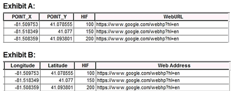 An ArcGIS user is previewing attribute tables for feature classes in ArcCatalog. The user needs to change the display of the fields from Exhibit A to Exhibit B. What should the user select after clicking the Table Options button?
(Multiple Choice)
4.7/5 (36)
Which spatial selection method allows a user to select polygons that share at least half of their area within another, single, large polygon?
(Multiple Choice)
4.9/5 (45)
A wildlife biologist is studying endangered mammals. The biologist has separate polygon feature classes that represent each mammal in a given geographic region. Which tool should the ArcGIS analyst use to create a new feature class containing all areas where the mammal weighs more than 45 kilograms?
(Multiple Choice)
4.7/5 (41)
A biologist must go into the field and record locations of every site that currently has standing water with mosquito larvae. Which application should the biologist use?
(Multiple Choice)
4.7/5 (41)
A GIS user typically works with the same geodatabase, the same set of locators, and the same layers added to the map. What is the most efficient way to simplify new project creation?
(Multiple Choice)
4.9/5 (42)
A researcher is mapping a small national park that has an east-west orientation near the equator. Which map projection should be used for this study area?
(Multiple Choice)
4.9/5 (32)
An analyst has project data in the form of shapefiles What should the analyst do to import the data to a file geodatabase?
(Multiple Choice)
4.9/5 (34)
A user signs into an ArcGIS Online organizational account to find a web layer that can be added to a web map. Which option takes the user directly to a page that shows the organization's featured content as a series of thumbnails?
(Multiple Choice)
4.9/5 (40)
Refer to the exhibit.  The exhibit below provides a conceptual view of a coordinate grid onto which all coordinate values snap to the grid mesh. The grid covers the extent of each dataset. An ArcGIS user is creating a new feature class, and needs to increase the numeric precision used to store the coordinate values. When modified, which of the following will increase the numeric precision used to store the coordinate values?
(Multiple Choice)
4.8/5 (33)
A GIS user has an address and must display the location of the address as a point on the map. The user has a general idea of where the address is located but needs a precise result How should the user efficiently perform this task in ArcMap?
(Multiple Choice)
4.9/5 (38)
A GIS technician needs to export multiple maps of individual county parcels. Which action should the technician take to achieve this in ArcGIS Pro?
(Multiple Choice)
4.9/5 (38)
An ArcGIS Online user is working with a feature layer representing regional village locations in a study area Each village should be symbolized by using a specific color which identifies the region. How should the user change the style of the village layer to accomplish this task?
(Multiple Choice)
4.7/5 (32)
Which file type can be dragged and dropped from the desktop directly into the ArcGIS Online map viewer?
(Multiple Choice)
4.9/5 (45)
An ArcGIS user is creating a map of a village. The user needs the map to clearly display features such as streets, trees, and businesses in the village. Which scale should the user choose for this map?
(Multiple Choice)
4.9/5 (41)
A GIS researcher needs to create a web map in ArcGIS Online and share it to the public. The researcher must make sure that certain features in the map do NOT show, based on the values in a certain field in the attribute table. The end user should still be able to access this features if needed. How should the researcher perform this task?
(Multiple Choice)
4.9/5 (39)
A technician has a map of cell phone towers. An additional tower needs to be added in the middle of a national park and the technician has only x,y coordinates recorded for the tower's location. How should the technician locate this tower on the map?
(Multiple Choice)
4.9/5 (37)
Which two methods can be used to create a feature class in ArcMap? (Choose two.)
(Multiple Choice)
4.9/5 (44)
An ArcGIS Pro user is working with several layers in a map that were added from feature classes in a geodatabase and then modified with custom symbology. The user copies the layers from the original map and pastes them into the Contents Pane in the second map. The user expected default symbology, but all the symbology modifications carried over. What should the user have done differently?
(Multiple Choice)
4.8/5 (37)
Filters
- Essay(0)
- Multiple Choice(0)
- Short Answer(0)
- True False(0)
- Matching(0)