Deck 18: GIS Models and Modeling
Full screen (f)
Question
Question
Question
Question
Question
Question
Question
Question
Question
Question
Question
Question
Question
Question
Question
You are asked to develop a vector-based index model. The model computes the index value using elevation and slope:
Index value = 2 * elevation + slope
The scoring (data standardization) systems for elevation and slope are as follows:
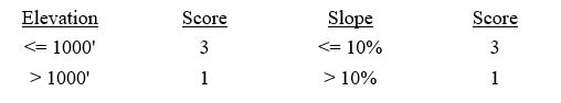 You already have the elevation and slope layers. Describe the procedure you will follow to complete the task.
Index value = 2 * elevation + slope
The scoring (data standardization) systems for elevation and slope are as follows:
You already have the elevation and slope layers. Describe the procedure you will follow to complete the task. Question
Question
Question
Question
Question
Question
Question
Question
Question
Question
Question

Unlock Deck
Sign up to unlock the cards in this deck!
Unlock Deck
Unlock Deck
1/26
Play
Full screen (f)
Deck 18: GIS Models and Modeling
1
An environmental model such as a soil erosion model must be capable of dealing with the interaction of many variables including physical and cultural variables.
True
2
A number of alternatives to the weighted linear combination method have been proposed in the literature. Describe one such alternative.
No Answer
3
A model that offers prediction of what the conditions of geospatial data could be or should be is called a
A) dynamic model
B) prescriptive model
C) deterministic model
D) static model
A) dynamic model
B) prescriptive model
C) deterministic model
D) static model
prescriptive model
4
Which of the following statements is not true about logistic regression?
A) None of these is correct
B) The independent variables are categorical, numeric, or both.
C) The dependent variable is categorical.
D) Logistic regression uses the same assumptions as linear regression.
A) None of these is correct
B) The independent variables are categorical, numeric, or both.
C) The dependent variable is categorical.
D) Logistic regression uses the same assumptions as linear regression.
Unlock Deck
Unlock for access to all 26 flashcards in this deck.
Unlock Deck
k this deck
5
In many instances, one can build a GIS model that is either vector-based or raster-based. What general guidelines should one use in deciding which type of model to build?
Unlock Deck
Unlock for access to all 26 flashcards in this deck.
Unlock Deck
k this deck
6
How does an index model differ from a binary model?
Unlock Deck
Unlock for access to all 26 flashcards in this deck.
Unlock Deck
k this deck
7
It is recommended that data sets used for validating a model are different from those for developing the model.
Unlock Deck
Unlock for access to all 26 flashcards in this deck.
Unlock Deck
k this deck
8
Explain the usefulness of regression models for spatial data.
Unlock Deck
Unlock for access to all 26 flashcards in this deck.
Unlock Deck
k this deck
9
Briefly describe the process of model calibration.
Unlock Deck
Unlock for access to all 26 flashcards in this deck.
Unlock Deck
k this deck
10
Explain the difference between "crisp threshold values" and "fuzzy sets" in multicriteria evaluation.
Unlock Deck
Unlock for access to all 26 flashcards in this deck.
Unlock Deck
k this deck
11
Many index models use the weighted linear combination method to calculate the index value. Explain the steps one follows in using the weighted linear combination method.
Unlock Deck
Unlock for access to all 26 flashcards in this deck.
Unlock Deck
k this deck
12
The Land Evaluation and Site Assessment (LESA) system produces a(n)
A) binary model
B) process model
C) index model
D) regression model
A) binary model
B) process model
C) index model
D) regression model
Unlock Deck
Unlock for access to all 26 flashcards in this deck.
Unlock Deck
k this deck
13
Suppose a county government asks you to do a GIS project for industrial site selection. The county uses the following criteria for site selection:
1) commercial zones
2) vacant or for sale
3) not subject to flooding
4) not more than one mile from a heavy duty road
5) less than 10% slope
6) at least five acres in size
The county has a GIS database with the following digital maps (in italic) that you can use for the project:
1) zoning includes commercial zones
2) parcel includes vacant parcels or parcels for sale
3) flood shows areas subject to flooding
4) roads includes heavy duty roads and other types of roads
5) slope groups slopes into 0-10%, 10-20%, 20-30%, and over 30%
Use a flow chart to explain how you can find potential industrial sites.
Unlock Deck
Unlock for access to all 26 flashcards in this deck.
Unlock Deck
k this deck
14
To build an index model, one must assign a(n) ____ to each variable or factor under consideration:
A) numeric score
B) ID
C) weight
A) numeric score
B) ID
C) weight
Unlock Deck
Unlock for access to all 26 flashcards in this deck.
Unlock Deck
k this deck
15
You are asked to develop a vector-based index model. The model computes the index value using elevation and slope:
Index value = 2 * elevation + slope
The scoring (data standardization) systems for elevation and slope are as follows:
You already have the elevation and slope layers. Describe the procedure you will follow to complete the task.
Index value = 2 * elevation + slope
The scoring (data standardization) systems for elevation and slope are as follows:
You already have the elevation and slope layers. Describe the procedure you will follow to complete the task. Unlock Deck
Unlock for access to all 26 flashcards in this deck.
Unlock Deck
k this deck
16
What does a spatially explicit model mean?
Unlock Deck
Unlock for access to all 26 flashcards in this deck.
Unlock Deck
k this deck
17
The output of a site analysis is typically a binary map.
Unlock Deck
Unlock for access to all 26 flashcards in this deck.
Unlock Deck
k this deck
18
Geographically weighted regression builds a regression model for each observation in the data set.
Unlock Deck
Unlock for access to all 26 flashcards in this deck.
Unlock Deck
k this deck
19
The output of an index model is a:
A) true or false map
B) ranked map
A) true or false map
B) ranked map
Unlock Deck
Unlock for access to all 26 flashcards in this deck.
Unlock Deck
k this deck
20
How does a static model differ from a dynamic model?
Unlock Deck
Unlock for access to all 26 flashcards in this deck.
Unlock Deck
k this deck
21
Which method is used by RUSLE to compute the average soil loss from six factors?
A) addition of the six factors
B) multiplication of the six factors
C) weighted linear combination of the six factors
A) addition of the six factors
B) multiplication of the six factors
C) weighted linear combination of the six factors
Unlock Deck
Unlock for access to all 26 flashcards in this deck.
Unlock Deck
k this deck
22
How does a deterministic model differ from a stochastic model?
Unlock Deck
Unlock for access to all 26 flashcards in this deck.
Unlock Deck
k this deck
23
A ___-based model is preferred if the model involves intense and complex computations:
A) raster
B) vector
A) raster
B) vector
Unlock Deck
Unlock for access to all 26 flashcards in this deck.
Unlock Deck
k this deck
24
A common approach to building a vector-based binary model is to
A) perform attribute data manipulation and analysis and overlay simultaneously
B) perform overlay first, followed by attribute data manipulation and analysis
C) perform attribute data manipulation and analysis first, followed by overlay
A) perform attribute data manipulation and analysis and overlay simultaneously
B) perform overlay first, followed by attribute data manipulation and analysis
C) perform attribute data manipulation and analysis first, followed by overlay
Unlock Deck
Unlock for access to all 26 flashcards in this deck.
Unlock Deck
k this deck
25
What are the options of linking a GIS to another software package (e.g., a statistical package)?
Unlock Deck
Unlock for access to all 26 flashcards in this deck.
Unlock Deck
k this deck
26
Which of the following analyses commonly uses index models?
A) a and c
B) site analysis
C) vulnerability analysis
D) b and c
E) suitability analysis
A) a and c
B) site analysis
C) vulnerability analysis
D) b and c
E) suitability analysis
Unlock Deck
Unlock for access to all 26 flashcards in this deck.
Unlock Deck
k this deck
Unlock Deck
Unlock for access to all 26 flashcards in this deck.


