Deck 1: Climates Around the World, Energy, Matter in the Atmosphere, Soil, Unstable Slopes, Streams, Lakes, Groundwater, Glaciers, Shorelines, and Changing Seal Levels
Full screen (f)
Question
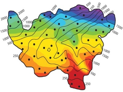
2)In classifying the climate of this imaginary country, the wettest and coolest areas are in the ______. The colors represent temperatures (warmest is red, coolest is purple), and the contour lines represent average precipitation in millimeters.
A)southwest.
B)northeast.
C)southeast.
D)northwest.
A)southwest.
B)northeast.
C)southeast.
D)northwest.
Question
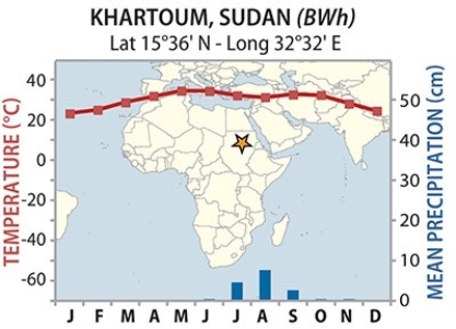
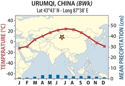
18)Though Khartoum and Urumqi both have dry BW climates, temperatures are much more variable for Urumqi. Why?
A)Urumqi's rain shadow
B)Urumqi's latitude
C)Khartoum's rain shadow
D)Khartoum's latitude
A)Urumqi's rain shadow
B)Urumqi's latitude
C)Khartoum's rain shadow
D)Khartoum's latitude
Question
Question
Question
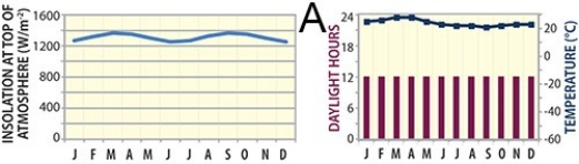
73)Which of these graphs represents a site near the equator, such as near Ecuador?
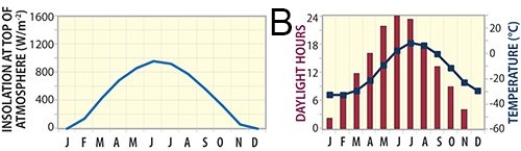
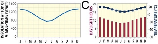
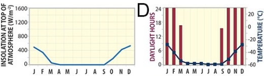
A)A
B)B
C)C
D)D
A)A
B)B
C)C
D)D
Question
Question
Question
17)The feature in this photograph is a(n):
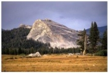
A)drumlin.
B)roche moutonnée.
C)kame.
D)esker.
A)drumlin.
B)roche moutonnée.
C)kame.
D)esker.
Question
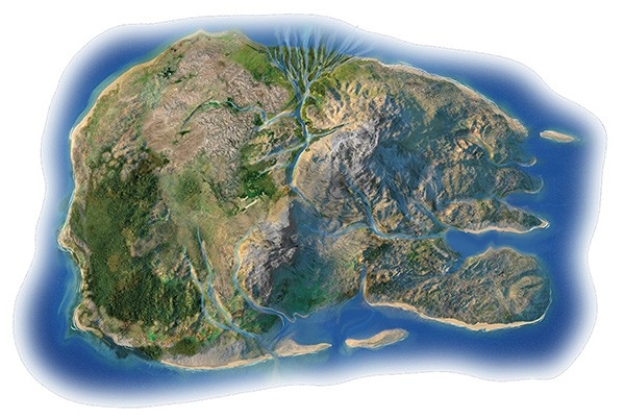
106)In the shorelines investigation, what shoreline feature is present along the eastern part of the north shore?
A)marine terrace
B)sandy beach
C)spit and sand bar
D)delta
E)submerged coastline
F)sea cliffs
A)marine terrace
B)sandy beach
C)spit and sand bar
D)delta
E)submerged coastline
F)sea cliffs
Question
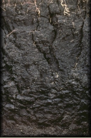
80)The clay-rich soil pictured below is a
A)Oxisol.
B)Spodosol.
C)Vertisol.
D)Gelisol.
A)Oxisol.
B)Spodosol.
C)Vertisol.
D)Gelisol.

Unlock Deck
Sign up to unlock the cards in this deck!
Unlock Deck
Unlock Deck
1/10
Play
Full screen (f)
Deck 1: Climates Around the World, Energy, Matter in the Atmosphere, Soil, Unstable Slopes, Streams, Lakes, Groundwater, Glaciers, Shorelines, and Changing Seal Levels
1
2)In classifying the climate of this imaginary country, the wettest and coolest areas are in the ______. The colors represent temperatures (warmest is red, coolest is purple), and the contour lines represent average precipitation in millimeters.
A)southwest.
B)northeast.
C)southeast.
D)northwest.
A)southwest.
B)northeast.
C)southeast.
D)northwest.
northeast.
2
18)Though Khartoum and Urumqi both have dry BW climates, temperatures are much more variable for Urumqi. Why?
A)Urumqi's rain shadow
B)Urumqi's latitude
C)Khartoum's rain shadow
D)Khartoum's latitude
A)Urumqi's rain shadow
B)Urumqi's latitude
C)Khartoum's rain shadow
D)Khartoum's latitude
Urumqi's latitude
3
71)Which of the following sites in South America would be best for generating electricity from solar energy, if clouds were NOT a factor?
A)Ushuaia, near the southern tip of the continent
B)a site at high latitudes (very far south in this case)
C)a site at mid latitudes
D)a site near the equator, such as the Galápagos
A)Ushuaia, near the southern tip of the continent
B)a site at high latitudes (very far south in this case)
C)a site at mid latitudes
D)a site near the equator, such as the Galápagos
a site near the equator, such as the Galápagos
4
72)Which of the following sites in South America would be likely be most impacted by clouds, decreasing the amount of electricity generated from solar energy?
A)Mar Chiquita, a site in the subtropics
B)Ushuaia, near the southern tip of the continent
C)Macapá, a site along the equator in the Amazon rain forest
D)all of these would be approximately the same, since they all have clouds
A)Mar Chiquita, a site in the subtropics
B)Ushuaia, near the southern tip of the continent
C)Macapá, a site along the equator in the Amazon rain forest
D)all of these would be approximately the same, since they all have clouds
Unlock Deck
Unlock for access to all 10 flashcards in this deck.
Unlock Deck
k this deck
5
73)Which of these graphs represents a site near the equator, such as near Ecuador?
A)A
B)B
C)C
D)D
A)A
B)B
C)C
D)D
Unlock Deck
Unlock for access to all 10 flashcards in this deck.
Unlock Deck
k this deck
6
136)The Ogallala Aquifer is located:
A)along the Ogallala River in Nebraska
B)west of the San Andreas Fault in California
C)beneath an area extending from South Dakota to the panhandle of Texas
A)along the Ogallala River in Nebraska
B)west of the San Andreas Fault in California
C)beneath an area extending from South Dakota to the panhandle of Texas
Unlock Deck
Unlock for access to all 10 flashcards in this deck.
Unlock Deck
k this deck
7
247)Entrenched meanders represent:
A)stream segments that have been straightened by humans
B)a stream that earlier had a low gradient but that has since eroded down into bedrock, retaining the shape of its bends
C)areas where sea level has risen and waves beveled across the coast
D)cutoff meanders of a meandering stream
A)stream segments that have been straightened by humans
B)a stream that earlier had a low gradient but that has since eroded down into bedrock, retaining the shape of its bends
C)areas where sea level has risen and waves beveled across the coast
D)cutoff meanders of a meandering stream
Unlock Deck
Unlock for access to all 10 flashcards in this deck.
Unlock Deck
k this deck
8
17)The feature in this photograph is a(n):
A)drumlin.
B)roche moutonnée.
C)kame.
D)esker.
A)drumlin.
B)roche moutonnée.
C)kame.
D)esker.
Unlock Deck
Unlock for access to all 10 flashcards in this deck.
Unlock Deck
k this deck
9
106)In the shorelines investigation, what shoreline feature is present along the eastern part of the north shore?
A)marine terrace
B)sandy beach
C)spit and sand bar
D)delta
E)submerged coastline
F)sea cliffs
A)marine terrace
B)sandy beach
C)spit and sand bar
D)delta
E)submerged coastline
F)sea cliffs
Unlock Deck
Unlock for access to all 10 flashcards in this deck.
Unlock Deck
k this deck
10
80)The clay-rich soil pictured below is a
A)Oxisol.
B)Spodosol.
C)Vertisol.
D)Gelisol.
A)Oxisol.
B)Spodosol.
C)Vertisol.
D)Gelisol.
Unlock Deck
Unlock for access to all 10 flashcards in this deck.
Unlock Deck
k this deck
Unlock Deck
Unlock for access to all 10 flashcards in this deck.


