Deck 15: Restless Realm: Oceans and Coasts
Full screen (f)
Question
Question
Question
Question
Question
Question
Question
Question
Question
Question
Question
Question
Question
Question
Question
Question
Question
Question
Question
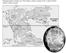
The Atlantic has been present since the Precambrian.
Question
Question
Question
Question
Question
Question
Question
Mt.Saint-Michel is separated from mainland Europe by approximately 1000 ft of relatively shallow water at high tide (as shown at left),but at low tide it is part of the wide,exposed intertidal zone (as shown at right).What might you infer about the size the sediment clasts found on the exposed surface at low tide? 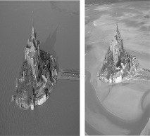
A) The clasts are large because waves would remove small clasts.
B) The clasts are small because the wide, gently-sloped bottom would diminish wave strength, thus decreasing the waves' erosive power.
C) The clasts are large because the rough seas of the area routinely move large cobbles across the shallow bottom.
D) The clasts are salt particles that precipitate and grow when the tide is out and quickly dissolve when the tide comes in.
Question
Question
Question
Question
Question
Question
Question
Why do you think most of the hurricane storm tracks on the figure below curve to the right? 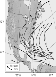
A) The advance portions of the huge hurricane air mass begins to encounter either the Rocky Mountains (and is deflected north) or the Appalachians (and is deflected northeastward).
B) Hurricanes are routed to the ocean currents/flow of the underlying North Atlantic Gyre.
C) The Coriolis effect deflects them to the right because this is in the northern hemisphere.
D) They don't really curve right; it looks that way only because of map distortion.
Question
Question
Based on the thermal image of the Gulf Stream (the inset box below),what would you conclude about the effects of ocean currents on the heat and temperature variations between equatorial regions and the poles? 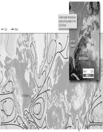
A) Ocean currents move colder water parallel to the equator.
B) Ocean currents move colder water toward equatorial seas.
C) Ocean currents move warmer water toward polar regions.
D) Both b and c are correct.
A) Ocean currents move colder water parallel to the equator.
B) Ocean currents move colder water toward equatorial seas.
C) Ocean currents move warmer water toward polar regions.
D) Both b and c are correct.
Question
Question
Question
Question
Question
Question
Question
Question
Question
Question
Question
Based on the figure below,what is likely to happen to coastal river deltas when sea level rises? 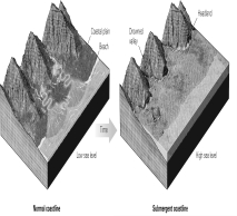
A) They would be submerged.
B) They would extend outward from increased sediment influx.
C) They would be "armored" with large clasts deposited by storm waves, as sea level slowly rose over them.
D) Both a and c are correct.
A) They would be submerged.
B) They would extend outward from increased sediment influx.
C) They would be "armored" with large clasts deposited by storm waves, as sea level slowly rose over them.
D) Both a and c are correct.
Question
Question
Question
Question
Question
Question
Question
Question
Question
Question
Question
What do you think the origin of the broad,flat surface is above the coastal cliffs shown below? 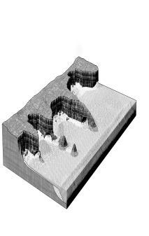
A) a wave-cut bench at an emergent coastline
B) a river terrace at a submergent coastline
C) a wave-cut bench at a submergent coastline
D) a river terrace at an emergent coastline
A) a wave-cut bench at an emergent coastline
B) a river terrace at a submergent coastline
C) a wave-cut bench at a submergent coastline
D) a river terrace at an emergent coastline

Unlock Deck
Sign up to unlock the cards in this deck!
Unlock Deck
Unlock Deck
1/57
Play
Full screen (f)
Deck 15: Restless Realm: Oceans and Coasts
1
Which type of coastline usually has a broader continental shelf?
A) a passive continental margin
B) an active continental margin
A) a passive continental margin
B) an active continental margin
A
2
Most of the igneous rocks within oceanic abyssal plains are ____________.
A) exposed at the surface of the sea floor
B) covered by sand and gravel introduced by rivers at deltas
C) covered by clay and the skeletal remains of microplankton
D) covered by limestones made up of the fragments of large invertebrate shells
A) exposed at the surface of the sea floor
B) covered by sand and gravel introduced by rivers at deltas
C) covered by clay and the skeletal remains of microplankton
D) covered by limestones made up of the fragments of large invertebrate shells
C
3
The water temperature at the abyssal plain is ____________.
A) warm (25-33°C)
B) near room temperature (25°C)
C) cold to your skin (10°C-15°C)
D) near freezing (1°C-2°C)
A) warm (25-33°C)
B) near room temperature (25°C)
C) cold to your skin (10°C-15°C)
D) near freezing (1°C-2°C)
D
4
The form and topography (depth profile)of the ocean floor is termed ____________.
A) orogeny
B) bathymetry
C) allocthony
D) aquitopography
A) orogeny
B) bathymetry
C) allocthony
D) aquitopography
Unlock Deck
Unlock for access to all 57 flashcards in this deck.
Unlock Deck
k this deck
5
The average depth of the abyssal plains below sea level is about ____________.
A) 1 km
B) 2.5 km
C) 4.5 km
D) 8 km
A) 1 km
B) 2.5 km
C) 4.5 km
D) 8 km
Unlock Deck
Unlock for access to all 57 flashcards in this deck.
Unlock Deck
k this deck
6
Which trench includes the world's deepest sea floor (more than 11 km below sea level)?
A) Peru-Chile Trench
B) Puerto Rican Trench
C) Marianas Trench
D) Kamchatka Trench
A) Peru-Chile Trench
B) Puerto Rican Trench
C) Marianas Trench
D) Kamchatka Trench
Unlock Deck
Unlock for access to all 57 flashcards in this deck.
Unlock Deck
k this deck
7
Approximately what percentage of Earth's surface is covered with water?
A) 30%
B) 50%
C) 70%
D) 85%
A) 30%
B) 50%
C) 70%
D) 85%
Unlock Deck
Unlock for access to all 57 flashcards in this deck.
Unlock Deck
k this deck
8
The shallowest portions of ocean found along the margins of continents are the ____________.
A) abyssal plains
B) continental rises
C) continental shelves
D) continental slopes
A) abyssal plains
B) continental rises
C) continental shelves
D) continental slopes
Unlock Deck
Unlock for access to all 57 flashcards in this deck.
Unlock Deck
k this deck
9
Compared to continental crust,oceanic crust is ____________.
A) denser
B) less dense
C) about the same density
A) denser
B) less dense
C) about the same density
Unlock Deck
Unlock for access to all 57 flashcards in this deck.
Unlock Deck
k this deck
10
A bathymetric map depicts ____________.
A) surface salinity
B) surface temperature
C) temperature at the sea floor
D) depth of the sea floor below sea level
A) surface salinity
B) surface temperature
C) temperature at the sea floor
D) depth of the sea floor below sea level
Unlock Deck
Unlock for access to all 57 flashcards in this deck.
Unlock Deck
k this deck
11
The majority of humans live away from coastlines.
Unlock Deck
Unlock for access to all 57 flashcards in this deck.
Unlock Deck
k this deck
12
If all the oceans evaporated,the average thickness of the resulting salt layer would be about ____________.
A) 6 m
B) 16 m
C) 60 m
D) 160 m
A) 6 m
B) 16 m
C) 60 m
D) 160 m
Unlock Deck
Unlock for access to all 57 flashcards in this deck.
Unlock Deck
k this deck
13
The most abundant igneous rock within oceanic crust is ____________.
A) gabbro
B) basalt
C) rhyolite
D) diorite
A) gabbro
B) basalt
C) rhyolite
D) diorite
Unlock Deck
Unlock for access to all 57 flashcards in this deck.
Unlock Deck
k this deck
14
What percentage of seawater,on average,consists of dissolved ions ("salts")?
A) 1.5%
B) 3.5%
C) 5.5%
D) 6.5%
A) 1.5%
B) 3.5%
C) 5.5%
D) 6.5%
Unlock Deck
Unlock for access to all 57 flashcards in this deck.
Unlock Deck
k this deck
15
Which portion of the sea floor is most steeply sloped?
A) abyssal plains
B) continental shelves
C) continental slopes
D) continental rises
A) abyssal plains
B) continental shelves
C) continental slopes
D) continental rises
Unlock Deck
Unlock for access to all 57 flashcards in this deck.
Unlock Deck
k this deck
16
Oceans' surface waters vary from ____________.
A) approximately 15 to 34°C
B) approximately 1 to 34°C
C) approximately 5 to 15°C
D) approximately 5 to 34°C
A) approximately 15 to 34°C
B) approximately 1 to 34°C
C) approximately 5 to 15°C
D) approximately 5 to 34°C
Unlock Deck
Unlock for access to all 57 flashcards in this deck.
Unlock Deck
k this deck
17
Compared to continental lithosphere,oceanic lithosphere is ____________.
A) thicker
B) thinner
C) approximately the same thickness
A) thicker
B) thinner
C) approximately the same thickness
Unlock Deck
Unlock for access to all 57 flashcards in this deck.
Unlock Deck
k this deck
18
The deepest segments of the ocean floor are found ____________.
A) along mid-ocean ridges
B) in the geographic centers of abyssal plains
C) in trenches associated with passive margins
D) in trenches associated with subduction zones
A) along mid-ocean ridges
B) in the geographic centers of abyssal plains
C) in trenches associated with passive margins
D) in trenches associated with subduction zones
Unlock Deck
Unlock for access to all 57 flashcards in this deck.
Unlock Deck
k this deck
19
The Atlantic has been present since the Precambrian.
Unlock Deck
Unlock for access to all 57 flashcards in this deck.
Unlock Deck
k this deck
20
____________ make up a majority of the ocean floor worldwide.
A) Abyssal plains
B) Continental rises
C) Continental shelves
D) Continental slopes
A) Abyssal plains
B) Continental rises
C) Continental shelves
D) Continental slopes
Unlock Deck
Unlock for access to all 57 flashcards in this deck.
Unlock Deck
k this deck
21
Rip currents flow ____________.
A) directly toward the shoreline
B) directly away from the shoreline
C) parallel to the shoreline
A) directly toward the shoreline
B) directly away from the shoreline
C) parallel to the shoreline
Unlock Deck
Unlock for access to all 57 flashcards in this deck.
Unlock Deck
k this deck
22
As waves approach shore in shallow water,their speed ____________.
A) increases
B) decreases
A) increases
B) decreases
Unlock Deck
Unlock for access to all 57 flashcards in this deck.
Unlock Deck
k this deck
23
Gyres ____________.
A) rotate clockwise in the northern hemisphere and counterclockwise in the southern hemisphere
B) rotate counterclockwise in the northern hemisphere and clockwise in the southern hemisphere
C) are caused by the Coriolis effect
D) Both a and c are correct.
A) rotate clockwise in the northern hemisphere and counterclockwise in the southern hemisphere
B) rotate counterclockwise in the northern hemisphere and clockwise in the southern hemisphere
C) are caused by the Coriolis effect
D) Both a and c are correct.
Unlock Deck
Unlock for access to all 57 flashcards in this deck.
Unlock Deck
k this deck
24
Rogue waves arise from constructive interference of multiple convergent waves and can be more than 100 ft high.
Unlock Deck
Unlock for access to all 57 flashcards in this deck.
Unlock Deck
k this deck
25
Upwelling currents exist along the east coasts of lands at the equator because of ______________.
A) sea-level variation between the world's oceans
B) the upwelling of denser, more saline cold bottomwaters
C) the divergence of surface currents that are part of oppositely spinning gyres in the two hemispheres
D) variation in tidal behavior between the two hemispheres
A) sea-level variation between the world's oceans
B) the upwelling of denser, more saline cold bottomwaters
C) the divergence of surface currents that are part of oppositely spinning gyres in the two hemispheres
D) variation in tidal behavior between the two hemispheres
Unlock Deck
Unlock for access to all 57 flashcards in this deck.
Unlock Deck
k this deck
26
Mt.Saint-Michel is separated from mainland Europe by approximately 1000 ft of relatively shallow water at high tide (as shown at left),but at low tide it is part of the wide,exposed intertidal zone (as shown at right).What might you infer about the size the sediment clasts found on the exposed surface at low tide?
A) The clasts are large because waves would remove small clasts.
B) The clasts are small because the wide, gently-sloped bottom would diminish wave strength, thus decreasing the waves' erosive power.
C) The clasts are large because the rough seas of the area routinely move large cobbles across the shallow bottom.
D) The clasts are salt particles that precipitate and grow when the tide is out and quickly dissolve when the tide comes in.
Unlock Deck
Unlock for access to all 57 flashcards in this deck.
Unlock Deck
k this deck
27
The most prominent force inducing tides on Earth is the ____________.
A) Sun's gravitational pull
B) Moon's gravitational pull
C) electromagnetic attraction between the Earth and the Sun
D) gravitational attraction between ocean waters and the continents on Earth
A) Sun's gravitational pull
B) Moon's gravitational pull
C) electromagnetic attraction between the Earth and the Sun
D) gravitational attraction between ocean waters and the continents on Earth
Unlock Deck
Unlock for access to all 57 flashcards in this deck.
Unlock Deck
k this deck
28
Longshore currents flow ____________.
A) directly toward the shoreline
B) directly away from the shoreline
C) parallel to the shoreline
A) directly toward the shoreline
B) directly away from the shoreline
C) parallel to the shoreline
Unlock Deck
Unlock for access to all 57 flashcards in this deck.
Unlock Deck
k this deck
29
You are diving for treasure lost when a ship wrecked several hundred years ago.You want to find the most treasure you can.Where do you dive?
A) in the direction the longshore currents come from
B) just below the depth of the wave base on calm days
C) below the depth of the wave base on rougher-weather days
D) into a submarine canyon
A) in the direction the longshore currents come from
B) just below the depth of the wave base on calm days
C) below the depth of the wave base on rougher-weather days
D) into a submarine canyon
Unlock Deck
Unlock for access to all 57 flashcards in this deck.
Unlock Deck
k this deck
30
You are the captain of a submarine and wish to travel through smooth water beneath a storm.If the ocean swells are rolling 1000 ft between crests,what must your cruising depth be below the water surface?
A) 100 ft
B) 200 ft
C) 400 ft
D) 500 ft
A) 100 ft
B) 200 ft
C) 400 ft
D) 500 ft
Unlock Deck
Unlock for access to all 57 flashcards in this deck.
Unlock Deck
k this deck
31
The worldwide average tidal range (difference in elevation between high and low tide)is approximately ____________.
A) 0.5 m
B) 0.5 to 1 m
C) 1 to 3 m
D) >3 m
A) 0.5 m
B) 0.5 to 1 m
C) 1 to 3 m
D) >3 m
Unlock Deck
Unlock for access to all 57 flashcards in this deck.
Unlock Deck
k this deck
32
The magnitude of tidal effect (lateral extent of the intertidal zone between low and high tides)is affected by the ____________.
A) steepness of the intertidal beach
B) position of the Sun
C) bathymetry of the region
D) Both a and c are correct.
A) steepness of the intertidal beach
B) position of the Sun
C) bathymetry of the region
D) Both a and c are correct.
Unlock Deck
Unlock for access to all 57 flashcards in this deck.
Unlock Deck
k this deck
33
Why do you think most of the hurricane storm tracks on the figure below curve to the right?
A) The advance portions of the huge hurricane air mass begins to encounter either the Rocky Mountains (and is deflected north) or the Appalachians (and is deflected northeastward).
B) Hurricanes are routed to the ocean currents/flow of the underlying North Atlantic Gyre.
C) The Coriolis effect deflects them to the right because this is in the northern hemisphere.
D) They don't really curve right; it looks that way only because of map distortion.
Unlock Deck
Unlock for access to all 57 flashcards in this deck.
Unlock Deck
k this deck
34
The Coriolis effect causes fluids or objects moving in the air or water to appear to be deflected because of the ____________.
A) ceaseless bombardment of Earth by solar radiation
B) slow migration of Earth's magnetic field, due to convection in the outer core
C) effects of plate tectonics on oceans and airmasses
D) rotation of the Earth
A) ceaseless bombardment of Earth by solar radiation
B) slow migration of Earth's magnetic field, due to convection in the outer core
C) effects of plate tectonics on oceans and airmasses
D) rotation of the Earth
Unlock Deck
Unlock for access to all 57 flashcards in this deck.
Unlock Deck
k this deck
35
Based on the thermal image of the Gulf Stream (the inset box below),what would you conclude about the effects of ocean currents on the heat and temperature variations between equatorial regions and the poles?
A) Ocean currents move colder water parallel to the equator.
B) Ocean currents move colder water toward equatorial seas.
C) Ocean currents move warmer water toward polar regions.
D) Both b and c are correct.
A) Ocean currents move colder water parallel to the equator.
B) Ocean currents move colder water toward equatorial seas.
C) Ocean currents move warmer water toward polar regions.
D) Both b and c are correct.
Unlock Deck
Unlock for access to all 57 flashcards in this deck.
Unlock Deck
k this deck
36
High tides can be as much as 17 m (more than 50 ft)above low tides,depending on location on Earth.
Unlock Deck
Unlock for access to all 57 flashcards in this deck.
Unlock Deck
k this deck
37
If an ocean current flows toward shore,then near shore there should be____________.
A) downwelling
B) upwelling
C) clockwise deflection
D) counterclockwise deflection
A) downwelling
B) upwelling
C) clockwise deflection
D) counterclockwise deflection
Unlock Deck
Unlock for access to all 57 flashcards in this deck.
Unlock Deck
k this deck
38
The density of seawater increases with ____________ and ____________.
A) increasing temperature; increasing salinity
B) decreasing temperature; increasing salinity
C) increasing temperature; decreasing salinity
D) decreasing temperature; decreasing salinity
A) increasing temperature; increasing salinity
B) decreasing temperature; increasing salinity
C) increasing temperature; decreasing salinity
D) decreasing temperature; decreasing salinity
Unlock Deck
Unlock for access to all 57 flashcards in this deck.
Unlock Deck
k this deck
39
A wave will disturb the water to a depth equal to ____________.
A) its wavelength
B) its surface amplitude
C) the bottom of the sea floor
D) one-half of its wavelength
A) its wavelength
B) its surface amplitude
C) the bottom of the sea floor
D) one-half of its wavelength
Unlock Deck
Unlock for access to all 57 flashcards in this deck.
Unlock Deck
k this deck
40
Major surface ocean currents travel ____________.
A) parallel to the prevailing wind direction in the region
B) in direct opposition to prevailing winds as a result of the Coriolis effect
C) at an angle to prevailing winds as a result of the Coriolis effect
D) at an angle to prevailing winds as a result of the Doppler effect
A) parallel to the prevailing wind direction in the region
B) in direct opposition to prevailing winds as a result of the Coriolis effect
C) at an angle to prevailing winds as a result of the Coriolis effect
D) at an angle to prevailing winds as a result of the Doppler effect
Unlock Deck
Unlock for access to all 57 flashcards in this deck.
Unlock Deck
k this deck
41
Along beaches,groins have ____________.
A) solved the problem of beach drift
B) increased erosion rates immediately upcurrent from the groin
C) increased erosion rates immediately downcurrent from the groin
D) increased depositional rates immediately downcurrent from the groin
A) solved the problem of beach drift
B) increased erosion rates immediately upcurrent from the groin
C) increased erosion rates immediately downcurrent from the groin
D) increased depositional rates immediately downcurrent from the groin
Unlock Deck
Unlock for access to all 57 flashcards in this deck.
Unlock Deck
k this deck
42
Lagoons are richer in sand than barrier islands.
Unlock Deck
Unlock for access to all 57 flashcards in this deck.
Unlock Deck
k this deck
43
Water-filled coastal valleys that were excavated by glaciers are termed ____________.
A) deltas
B) tombolos
C) fjords
D) fords
A) deltas
B) tombolos
C) fjords
D) fords
Unlock Deck
Unlock for access to all 57 flashcards in this deck.
Unlock Deck
k this deck
44
Estuaries most commonly have salinity that is ____________.
A) identical to normal marine salinity
B) identical to freshwater
C) hypersaline (greater than normal marine salinity)
D) brackish (between freshwater and marine salinity)
A) identical to normal marine salinity
B) identical to freshwater
C) hypersaline (greater than normal marine salinity)
D) brackish (between freshwater and marine salinity)
Unlock Deck
Unlock for access to all 57 flashcards in this deck.
Unlock Deck
k this deck
45
What would the long-term effect of a massive global cooling be on the occurrence of hurricanes?
A) They would occur closer to the polar regions because of increases in sea ice.
B) There would be fewer hurricanes because ocean surface waters would be cooler.
C) There would be more hurricanes because of greater average wind speeds, as may have occurred during the last ice age.
D) None.
A) They would occur closer to the polar regions because of increases in sea ice.
B) There would be fewer hurricanes because ocean surface waters would be cooler.
C) There would be more hurricanes because of greater average wind speeds, as may have occurred during the last ice age.
D) None.
Unlock Deck
Unlock for access to all 57 flashcards in this deck.
Unlock Deck
k this deck
46
Based on the figure below,what is likely to happen to coastal river deltas when sea level rises?
A) They would be submerged.
B) They would extend outward from increased sediment influx.
C) They would be "armored" with large clasts deposited by storm waves, as sea level slowly rose over them.
D) Both a and c are correct.
A) They would be submerged.
B) They would extend outward from increased sediment influx.
C) They would be "armored" with large clasts deposited by storm waves, as sea level slowly rose over them.
D) Both a and c are correct.
Unlock Deck
Unlock for access to all 57 flashcards in this deck.
Unlock Deck
k this deck
47
Which type of coastline would most likely contain estuaries or fjords?
A) subductive coastline
B) emergent coastline
C) submergent coastline
D) divergent coastline
A) subductive coastline
B) emergent coastline
C) submergent coastline
D) divergent coastline
Unlock Deck
Unlock for access to all 57 flashcards in this deck.
Unlock Deck
k this deck
48
Which statement is NOT true about living coral reefs?
A) Coral reefs are generally restricted to water temperatures of 18°C or less.
B) Coral reefs are generally restricted to depths of 60 m below sea level.
C) The calcite reef skeleton is built by algae.
D) Algae provide oxygen that a key reef organism uses in order to secrete calcite.
A) Coral reefs are generally restricted to water temperatures of 18°C or less.
B) Coral reefs are generally restricted to depths of 60 m below sea level.
C) The calcite reef skeleton is built by algae.
D) Algae provide oxygen that a key reef organism uses in order to secrete calcite.
Unlock Deck
Unlock for access to all 57 flashcards in this deck.
Unlock Deck
k this deck
49
What effect do most ocean waves have on silt and mud particles that are near-shore or on the beach?
A) suspend them and carry them away
B) loft them into the air when the waves break, where enough of them are carried inland by winds to form sand dunes
C) concentrate them to make gentle, muddy or soft beaches
D) cause lithification into weak shales and mudstones because of interaction with salts (ions) in seawater
Unlock Deck
Unlock for access to all 57 flashcards in this deck.
Unlock Deck
k this deck
50
It is believed that global warming will result in higher sea levels and warmer ocean surface waters.How will this affect the Gulf Coast and southeast coast of the United States?
A) Flooding from combinations of storms and high tides will be more common.
B) Hurricanes will become more common.
C) Coral reefs within Lake Okeechobee and other lakes of the region suffer from increased acidity of waters around the globe.
D) Both a and b are correct.
A) Flooding from combinations of storms and high tides will be more common.
B) Hurricanes will become more common.
C) Coral reefs within Lake Okeechobee and other lakes of the region suffer from increased acidity of waters around the globe.
D) Both a and b are correct.
Unlock Deck
Unlock for access to all 57 flashcards in this deck.
Unlock Deck
k this deck
51
Waves ___________.
A) refract (bend) so as to impact the shore in a nearly parallel manner
B) refract so as to impact the shore nearly perpendicular to the shoreline
C) reflect directly backward from the angle at which they approached the shoreline
D) are reflected off the shoreline, but never refract
A) refract (bend) so as to impact the shore in a nearly parallel manner
B) refract so as to impact the shore nearly perpendicular to the shoreline
C) reflect directly backward from the angle at which they approached the shoreline
D) are reflected off the shoreline, but never refract
Unlock Deck
Unlock for access to all 57 flashcards in this deck.
Unlock Deck
k this deck
52
Wave refraction should erode an irregular coastline ____________.
A) evenly along the length of the coast
B) mostly along headlands
C) mostly in bays
A) evenly along the length of the coast
B) mostly along headlands
C) mostly in bays
Unlock Deck
Unlock for access to all 57 flashcards in this deck.
Unlock Deck
k this deck
53
Black sand beaches are composed of ____________.
A) magnetite grains
B) dolomite fragments
C) iron ore fragments
D) basalt fragments
A) magnetite grains
B) dolomite fragments
C) iron ore fragments
D) basalt fragments
Unlock Deck
Unlock for access to all 57 flashcards in this deck.
Unlock Deck
k this deck
54
If you position a drill ship over a guyot,what would you expect to drill into?
A) limestone and then pillow basalts
B) limestone and then rhyolite
C) limestone or other sedimentary rock, then gabbror
D) limestone or other sedimentary rock, then basalt
A) limestone and then pillow basalts
B) limestone and then rhyolite
C) limestone or other sedimentary rock, then gabbror
D) limestone or other sedimentary rock, then basalt
Unlock Deck
Unlock for access to all 57 flashcards in this deck.
Unlock Deck
k this deck
55
When the sea level rises,the ocean may invade a river valley,producing a nearshore body of water of mixed and variable salinity termed a(n)____________.
A) atoll
B) lagoon
C) estuary
D) jetty
A) atoll
B) lagoon
C) estuary
D) jetty
Unlock Deck
Unlock for access to all 57 flashcards in this deck.
Unlock Deck
k this deck
56
Beach swash occurs because of which two factors?
A) upwelling, and longshore currents
B) breaking waves and longshore currents
C) tides, and downwelling currents
D) breaking waves tides
A) upwelling, and longshore currents
B) breaking waves and longshore currents
C) tides, and downwelling currents
D) breaking waves tides
Unlock Deck
Unlock for access to all 57 flashcards in this deck.
Unlock Deck
k this deck
57
What do you think the origin of the broad,flat surface is above the coastal cliffs shown below?
A) a wave-cut bench at an emergent coastline
B) a river terrace at a submergent coastline
C) a wave-cut bench at a submergent coastline
D) a river terrace at an emergent coastline
A) a wave-cut bench at an emergent coastline
B) a river terrace at a submergent coastline
C) a wave-cut bench at a submergent coastline
D) a river terrace at an emergent coastline
Unlock Deck
Unlock for access to all 57 flashcards in this deck.
Unlock Deck
k this deck
Unlock Deck
Unlock for access to all 57 flashcards in this deck.


