Deck 1: The Nature of Physical Geography
Full screen (f)
Question
Question
Question
Question
Question
Question
Question
Question
Question
Question
Question
Question
Question
Question
Question
Question
Question
Question
Question
Question
Question
In the topographic map below,the place with the greatest relief among the four choices is at 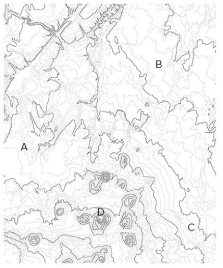
A)A.
B)B.
C)C.
D)D.
A)A.
B)B.
C)C.
D)D.
Question
Question
Question
Question
Question
Question
Question
Question
Question
Question
Question
Question
Question
In the diagram below,the left arrow represents 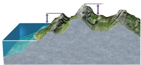
A)elevation and the right arrow represents relief.
B)relief and the right arrow represents slope.
C)elevation and the right arrow represents depth.
D)relief and the right arrow represents elevation.
A)elevation and the right arrow represents relief.
B)relief and the right arrow represents slope.
C)elevation and the right arrow represents depth.
D)relief and the right arrow represents elevation.
Question
Question
Question
Question
Question
The most logical place to build a soccer or football field on the following map would be at 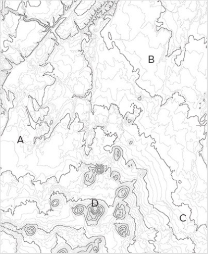
A)A.
B)B.
C)C.
D)D.
A)A.
B)B.
C)C.
D)D.
Question
Question
Question
The map below uses what type of map projection? 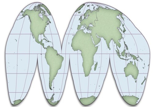
A)Cylindrical
B)Sinusoidal
C)Conical
D)Planar
A)Cylindrical
B)Sinusoidal
C)Conical
D)Planar
Question
Question
Question
Question
Question
The map below shows zone numbers associated with which coordinate system? 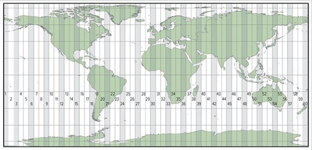
A)Universal Transverse Mercator
B)State Plane Coordinate System
C)Public Land Survey System
A)Universal Transverse Mercator
B)State Plane Coordinate System
C)Public Land Survey System
Question
Question
Question
Question
Question
Question
Question
Question
Question
Question
Question
Question
Question
Question
Question
Question
Question
Question
Question
Question
Question
Question
Question
Question
Question
Question
Question
Question
Question
On the map below,all of the following would be considered "interpretations" except 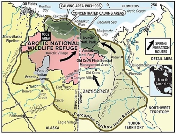
A)spring migration routes.
B)Ivvavic National Park.
C)concentrated calving areas.
D)porcupine caribou herd range.
A)spring migration routes.
B)Ivvavic National Park.
C)concentrated calving areas.
D)porcupine caribou herd range.
Question
Question
Question
Question

Unlock Deck
Sign up to unlock the cards in this deck!
Unlock Deck
Unlock Deck
1/84
Play
Full screen (f)
Deck 1: The Nature of Physical Geography
1
Which of the following topics of study would best incorporate the holistic perspective?
A)The impact of political policies on soil erosion
B)The examination of soil grains under a microscope to identify the amount of air space between grains
C)The degree to which soil particles expand when they are wet and contract when they dry out
D)Identifying the soil type from a sample collected in the field
A
2
A dynamic system refers to a system in which
A)motion causes the matter within the system to contain less energy than it would have contained when sitting still.
B)water molecules are constantly increasing in speed over time.
C)the first law of thermodynamics does not apply.
D)matter,energy,or both are constantly changing their position,amounts,or form.
D
3
Which of the following clues would the steepness of a slope,by itself,be most directly able to provide to a geographer in understanding a place?
A)It suggests the ethnicity of human settlement that may have lived on the slope.
B)It suggests the type of rock that might be present to form soils.
C)It suggests how far the location is from the equator.
D)It suggests the strength of the wind at the location.
A)It suggests the ethnicity of human settlement that may have lived on the slope.
B)It suggests the type of rock that might be present to form soils.
C)It suggests how far the location is from the equator.
D)It suggests the strength of the wind at the location.
B
4
The conceptual basis of geographic questions involves the notion that
A)the location of an object affects other features in the natural environment but not the human environment.
B)the location of an object is affected by other features in the natural environment but not the human environment.
C)the location of an object affects,and is affected by,other features in both the natural and human environment.
D)the location of an object is unique and largely unaffected by other features in both the natural and human environment.
Unlock Deck
Unlock for access to all 84 flashcards in this deck.
Unlock Deck
k this deck
5
A hypothesis is a
A)conclusion based on results of an investigation.
B)proposed explanation developed before formal investigation.
C)question developed that leads to an observation.
D)strategy for solving a scientific problem.
A)conclusion based on results of an investigation.
B)proposed explanation developed before formal investigation.
C)question developed that leads to an observation.
D)strategy for solving a scientific problem.
Unlock Deck
Unlock for access to all 84 flashcards in this deck.
Unlock Deck
k this deck
6
Which of the following is not a feature of what physical geographers study?
A)Impacts of spatial distributions of the natural environment on people
B)Processes that created and changed the spatial distributions of natural features
C)Interconnections between different aspects of the natural environment
D)All of these are features of what physical geographers study.
A)Impacts of spatial distributions of the natural environment on people
B)Processes that created and changed the spatial distributions of natural features
C)Interconnections between different aspects of the natural environment
D)All of these are features of what physical geographers study.
Unlock Deck
Unlock for access to all 84 flashcards in this deck.
Unlock Deck
k this deck
7
Which of the following statements is true about the transfer of energy,matter,or momentum in the atmosphere?
A)Momentum is usually transferred from the surface upward.
B)Energy transfer occurs when water changes state between solid,liquid,or gas.
C)Matter is transferred so effectively that the spatial distribution of matter in the atmosphere is uniform.
D)No transfer of energy,matter,or momentum can occur in the polar part of the atmosphere.
Unlock Deck
Unlock for access to all 84 flashcards in this deck.
Unlock Deck
k this deck
8
The geographic perspective that distinguishes geography from other fields of study means that
A)geographers use computers only after they examine maps.
B)geographers examine how the spatial features affect and are affected by nonspatial issues.
C)geographers use field work to report results.
D)geographers do not need to follow the scientific method when they solve research problems.
A)geographers use computers only after they examine maps.
B)geographers examine how the spatial features affect and are affected by nonspatial issues.
C)geographers use field work to report results.
D)geographers do not need to follow the scientific method when they solve research problems.
Unlock Deck
Unlock for access to all 84 flashcards in this deck.
Unlock Deck
k this deck
9
The most likely and direct consequence of a reduced rate of "burial" of sediment in the rock cycle would be
A)the delayed rate of formation of rock.
B)slower rates of uplift of rocks back to the surface.
C)more rapid deposition of more sediment.
D)increased rates of rock deformation.
A)the delayed rate of formation of rock.
B)slower rates of uplift of rocks back to the surface.
C)more rapid deposition of more sediment.
D)increased rates of rock deformation.
Unlock Deck
Unlock for access to all 84 flashcards in this deck.
Unlock Deck
k this deck
10
Once a hypothesis is rejected,
A)an observation cannot be made.
B)the experiment fails.
C)it can be revisited in future studies.
D)the scientific method has been violated.
A)an observation cannot be made.
B)the experiment fails.
C)it can be revisited in future studies.
D)the scientific method has been violated.
Unlock Deck
Unlock for access to all 84 flashcards in this deck.
Unlock Deck
k this deck
11
The relationship between mountains and precipitation can be generalized by saying that
A)mountaintops tend to have more precipitation in summer but less precipitation in winter than the surrounding lowlands.
B)mountaintops tend to have more precipitation in winter but less precipitation in summer than the surrounding lowlands.
C)mountaintops generally experience more precipitation than the surrounding lowlands.
D)mountaintops generally experience less precipitation that the surrounding lowlands.
Unlock Deck
Unlock for access to all 84 flashcards in this deck.
Unlock Deck
k this deck
12
Geography is considered to be
A)a natural science.
B)a social science.
C)both a natural and social science.
D)neither a natural nor a social science.
A)a natural science.
B)a social science.
C)both a natural and social science.
D)neither a natural nor a social science.
Unlock Deck
Unlock for access to all 84 flashcards in this deck.
Unlock Deck
k this deck
13
The hydrologic cycle includes all of the following processes except
A)evaporation.
B)precipitation.
C)runoff.
D)uplift.
A)evaporation.
B)precipitation.
C)runoff.
D)uplift.
Unlock Deck
Unlock for access to all 84 flashcards in this deck.
Unlock Deck
k this deck
14
Which of the following would be an example of qualitative data?
A)A physical geographer measuring the time required for a plume of air pollution to reach a town
B)A physical geographer taking a census of the number of pine trees infested with a certain disease
C)A physical geographer monitoring the water temperature in a stream
D)A physical geographer noting the color of a soil
Unlock Deck
Unlock for access to all 84 flashcards in this deck.
Unlock Deck
k this deck
15
The "sphere" that intersects with all of the other spheres is the
A)atmosphere.
B)biosphere.
C)hydrosphere.
D)lithosphere.
A)atmosphere.
B)biosphere.
C)hydrosphere.
D)lithosphere.
Unlock Deck
Unlock for access to all 84 flashcards in this deck.
Unlock Deck
k this deck
16
A snowball that rolls down a hill,gradually gaining more and more mass and rolling faster and faster as it continues,would be an example of a(n)
A)positive feedback system.
B)negative feedback system.
C)open system.
D)closed system.
A)positive feedback system.
B)negative feedback system.
C)open system.
D)closed system.
Unlock Deck
Unlock for access to all 84 flashcards in this deck.
Unlock Deck
k this deck
17
When you shake fish food into an aquarium,you are contributing to a(n)
A)open system.
B)negative feedback system.
C)positive feedback system.
D)closed system.
A)open system.
B)negative feedback system.
C)positive feedback system.
D)closed system.
Unlock Deck
Unlock for access to all 84 flashcards in this deck.
Unlock Deck
k this deck
18
The difference between open and closed systems is that
A)open systems are not predictable but closed systems are.
B)open systems can acquire matter and energy,but closed systems cannot.
C)open systems are much simpler in terms of the number of interactions between objects in the system.
D)open systems occur on land and closed systems occur in the ocean.
Unlock Deck
Unlock for access to all 84 flashcards in this deck.
Unlock Deck
k this deck
19
Which of the following is an example of quantitative data?
A)A physical geographer sketching the general appearance of a landscape
B)A physical geographer describing the shape of rock fragments
C)A physical geographer measuring the total rainfall from a storm
D)A physical geographer observing that the clouds are flat and blanket-like
A)A physical geographer sketching the general appearance of a landscape
B)A physical geographer describing the shape of rock fragments
C)A physical geographer measuring the total rainfall from a storm
D)A physical geographer observing that the clouds are flat and blanket-like
Unlock Deck
Unlock for access to all 84 flashcards in this deck.
Unlock Deck
k this deck
20
The lithosphere refers to the
A)plasticky interior of the Earth that moves in response to heating from the interior.
B)molten lava that is ejected from volcanoes.
C)land part of the Earth only.
D)solid upper part of the Earth,including the crust and uppermost mantle.
A)plasticky interior of the Earth that moves in response to heating from the interior.
B)molten lava that is ejected from volcanoes.
C)land part of the Earth only.
D)solid upper part of the Earth,including the crust and uppermost mantle.
Unlock Deck
Unlock for access to all 84 flashcards in this deck.
Unlock Deck
k this deck
21
In the topographic map below,the place with the greatest relief among the four choices is at
A)A.
B)B.
C)C.
D)D.
A)A.
B)B.
C)C.
D)D.
Unlock Deck
Unlock for access to all 84 flashcards in this deck.
Unlock Deck
k this deck
22
The most direct example of an atmosphere-lithosphere exchange is
A)a forest being planted.
B)an active coral reef colony.
C)a volcanic eruption.
D)a wave breaking on a shoreline.
A)a forest being planted.
B)an active coral reef colony.
C)a volcanic eruption.
D)a wave breaking on a shoreline.
Unlock Deck
Unlock for access to all 84 flashcards in this deck.
Unlock Deck
k this deck
23
Points on a map to the same side of a certain contour on a topographic map will all have
A)the same mineral composition,unless there is no index contour on the map.
B)elevations that are all above,or all below,the elevation that the contour represents.
C)rivers and streams that run parallel to the contour line,while points on the other side of that contour have rivers and streams that do not run parallel to the contour line.
D)more similar climate than points to the other side of that contour line.
Unlock Deck
Unlock for access to all 84 flashcards in this deck.
Unlock Deck
k this deck
24
Which of the following is an example of a small circle?
A)Prime Meridian
B)Tropic of Cancer
C)Equator
D)International Date Line
A)Prime Meridian
B)Tropic of Cancer
C)Equator
D)International Date Line
Unlock Deck
Unlock for access to all 84 flashcards in this deck.
Unlock Deck
k this deck
25
The significance of any great circle is that it always
A)connects two points on the surface of a sphere with the shortest distance.
B)follows the same line of latitude.
C)passes through the point where the equator intersects with the Prime Meridian.
D)passes through the North or South Pole.
A)connects two points on the surface of a sphere with the shortest distance.
B)follows the same line of latitude.
C)passes through the point where the equator intersects with the Prime Meridian.
D)passes through the North or South Pole.
Unlock Deck
Unlock for access to all 84 flashcards in this deck.
Unlock Deck
k this deck
26
Shaded relief maps are most directly helpful in
A)determining the average annual climatic features across the Earth's surface.
B)identifying the shape of features of the Earth.
C)representing the types of features on the surface of the Earth.
D)"seeing through" the surface of the Earth to the subsurface.
A)determining the average annual climatic features across the Earth's surface.
B)identifying the shape of features of the Earth.
C)representing the types of features on the surface of the Earth.
D)"seeing through" the surface of the Earth to the subsurface.
Unlock Deck
Unlock for access to all 84 flashcards in this deck.
Unlock Deck
k this deck
27
All of the following are typical effects of dam construction except
A)interruption of the normal seasonal variation in flows of water.
B)increased amount of sediment carried downstream of the dam.
C)disruption of natural ecosystems.
D)protecting towns from flooding.
A)interruption of the normal seasonal variation in flows of water.
B)increased amount of sediment carried downstream of the dam.
C)disruption of natural ecosystems.
D)protecting towns from flooding.
Unlock Deck
Unlock for access to all 84 flashcards in this deck.
Unlock Deck
k this deck
28
The meanings of elevation and relief imply that
A)elevation and relief are the same when the location is far inland.
B)elevation cannot be smaller than relief except when comparing areas below sea level.
C)relief must always exceed elevation in coastal areas but elevation must always exceed relief in mountainous areas.
D)the units of measurement of elevation must be different from the units of measurement of relief.
Unlock Deck
Unlock for access to all 84 flashcards in this deck.
Unlock Deck
k this deck
29
All of the following are likely effects of deforestation except
A)increased runoff into rivers and streams.
B)increased rate of soil erosion.
C)increased rate at which carbon dioxide is extracted out of the atmosphere.
D)increased rate of destruction of plant and animal habitats.
A)increased runoff into rivers and streams.
B)increased rate of soil erosion.
C)increased rate at which carbon dioxide is extracted out of the atmosphere.
D)increased rate of destruction of plant and animal habitats.
Unlock Deck
Unlock for access to all 84 flashcards in this deck.
Unlock Deck
k this deck
30
If two places have the same latitude but different longitudes,
A)the two places are directly east or west of each other.
B)the two places are directly north or south of each other.
C)the places will be directly east or west of each other on some map projections but not others.
D)the places will be directly north or south of each other on some map projections but not others.
Unlock Deck
Unlock for access to all 84 flashcards in this deck.
Unlock Deck
k this deck
31
One of the main roles of plants in biogeochemical cycles is to
A)reduce the rate of weathering.
B)decrease the amount of time that water remains in contact with rocks and soils.
C)extract carbon dioxide from the atmosphere.
D)harden the soils.
A)reduce the rate of weathering.
B)decrease the amount of time that water remains in contact with rocks and soils.
C)extract carbon dioxide from the atmosphere.
D)harden the soils.
Unlock Deck
Unlock for access to all 84 flashcards in this deck.
Unlock Deck
k this deck
32
Geographic factors are important when considering environmental issues or when evaluating potential sites for new agricultural area or business because
A)location and spatial distributions often affect environmental,social,or economic behavior.
B)the most important environmental issues and the advantages of sites for new agricultural areas or businesses are often the same across space.
C)environmental policies and zoning regulations seldom consider geographic factors.
D)it is seldom important to investigate environmental issues or evaluate potential sites from a holistic approach.
Unlock Deck
Unlock for access to all 84 flashcards in this deck.
Unlock Deck
k this deck
33
In the rock cycle,sediment is stripped away and transported by the process of ________ after the process of ________ has taken place.
A)erosion; weathering.
B)weathering; erosion.
C)uplift; solidification.
D)solidification; uplift.
A)erosion; weathering.
B)weathering; erosion.
C)uplift; solidification.
D)solidification; uplift.
Unlock Deck
Unlock for access to all 84 flashcards in this deck.
Unlock Deck
k this deck
34
In the diagram below,the left arrow represents
A)elevation and the right arrow represents relief.
B)relief and the right arrow represents slope.
C)elevation and the right arrow represents depth.
D)relief and the right arrow represents elevation.
A)elevation and the right arrow represents relief.
B)relief and the right arrow represents slope.
C)elevation and the right arrow represents depth.
D)relief and the right arrow represents elevation.
Unlock Deck
Unlock for access to all 84 flashcards in this deck.
Unlock Deck
k this deck
35
The cycling of chemical substances throughout the biosphere is accomplished through
A)vertical transfer of momentum.
B)the first law of thermodynamics.
C)the rock cycle.
D)the work of living things and physical and chemical processes.
A)vertical transfer of momentum.
B)the first law of thermodynamics.
C)the rock cycle.
D)the work of living things and physical and chemical processes.
Unlock Deck
Unlock for access to all 84 flashcards in this deck.
Unlock Deck
k this deck
36
Which of the following is true of meridians?
A)Meridians run from east to west.
B)The highest degree label for meridians is 90°.
C)Meridians are always parallel to each other.
D)Meridians always follow great circles.
A)Meridians run from east to west.
B)The highest degree label for meridians is 90°.
C)Meridians are always parallel to each other.
D)Meridians always follow great circles.
Unlock Deck
Unlock for access to all 84 flashcards in this deck.
Unlock Deck
k this deck
37
When the lithosphere and biosphere interact,
A)plants remove nutrients from the soil but return few if any nutrients to the soil.
B)plants return nutrients to the soil but remove few if any nutrients from the soil.
C)plants remove nutrients from the soil and return nutrients to the soil.
D)plants acquire their nutrients directly from the air so that they do not disturb the nutrient structure in the soil.
Unlock Deck
Unlock for access to all 84 flashcards in this deck.
Unlock Deck
k this deck
38
A steep slope implies a
A)weak gradient and closely spaced contours.
B)steep gradient and closely spaced contours.
C)weak gradient and widely spaced contours.
D)steep gradient and widely spaced contours.
A)weak gradient and closely spaced contours.
B)steep gradient and closely spaced contours.
C)weak gradient and widely spaced contours.
D)steep gradient and widely spaced contours.
Unlock Deck
Unlock for access to all 84 flashcards in this deck.
Unlock Deck
k this deck
39
The most logical place to build a soccer or football field on the following map would be at
A)A.
B)B.
C)C.
D)D.
A)A.
B)B.
C)C.
D)D.
Unlock Deck
Unlock for access to all 84 flashcards in this deck.
Unlock Deck
k this deck
40
A gradient of 0.037 implies that
A)the slope will drop by 37 meters or feet or inches for every 1000 meters or feet or inches of horizontal distance.
B)there are 0.037 times as many index contours as there are other contours on the map.
C)the slope is steeper than another location with a gradient of 0.040.
D)topographic map or shaded-relief map cannot be constructed for the area because the gradient is too small.
Unlock Deck
Unlock for access to all 84 flashcards in this deck.
Unlock Deck
k this deck
41
0° of latitude is found at the ________,and 90° of latitude is found at the ________.
A)South Pole; North Pole
B)South Pole; Equator
C)Equator; North Pole
D)North Pole; Prime Meridian
A)South Pole; North Pole
B)South Pole; Equator
C)Equator; North Pole
D)North Pole; Prime Meridian
Unlock Deck
Unlock for access to all 84 flashcards in this deck.
Unlock Deck
k this deck
42
The map below uses what type of map projection?
A)Cylindrical
B)Sinusoidal
C)Conical
D)Planar
A)Cylindrical
B)Sinusoidal
C)Conical
D)Planar
Unlock Deck
Unlock for access to all 84 flashcards in this deck.
Unlock Deck
k this deck
43
All map projections introduce at least some distortion because
A)it is impossible to represent a three-dimensional surface on a two-dimensional plane perfectly.
B)the best mathematical algorithms used in map projections have not been discovered yet.
C)the Earth is not a perfect sphere.
D)the Earth's orbit around the Sun is not perfectly circular.
A)it is impossible to represent a three-dimensional surface on a two-dimensional plane perfectly.
B)the best mathematical algorithms used in map projections have not been discovered yet.
C)the Earth is not a perfect sphere.
D)the Earth's orbit around the Sun is not perfectly circular.
Unlock Deck
Unlock for access to all 84 flashcards in this deck.
Unlock Deck
k this deck
44
The Prime Meridian separates
A)great circles from small circles.
B)the Northern Hemisphere from the Southern Hemisphere.
C)the Eastern Hemisphere from the Western Hemisphere.
D)places experiencing one day on the calendar from places experiencing another day on the calendar.
A)great circles from small circles.
B)the Northern Hemisphere from the Southern Hemisphere.
C)the Eastern Hemisphere from the Western Hemisphere.
D)places experiencing one day on the calendar from places experiencing another day on the calendar.
Unlock Deck
Unlock for access to all 84 flashcards in this deck.
Unlock Deck
k this deck
45
The detailed roads of a very small area,such as your neighborhood,would need to be shown on a map at what scale?
A)Large
B)Small
A)Large
B)Small
Unlock Deck
Unlock for access to all 84 flashcards in this deck.
Unlock Deck
k this deck
46
The use of stereopairs is important in creating maps because they
A)allow the scale to become smaller.
B)remove the distortions introduced by the map projection.
C)reveal the three-dimensional features of a landscape.
D)penetrate through the clouds that may have been present on the day when the aerial photograph was taken.
A)allow the scale to become smaller.
B)remove the distortions introduced by the map projection.
C)reveal the three-dimensional features of a landscape.
D)penetrate through the clouds that may have been present on the day when the aerial photograph was taken.
Unlock Deck
Unlock for access to all 84 flashcards in this deck.
Unlock Deck
k this deck
47
The map below shows zone numbers associated with which coordinate system?
A)Universal Transverse Mercator
B)State Plane Coordinate System
C)Public Land Survey System
A)Universal Transverse Mercator
B)State Plane Coordinate System
C)Public Land Survey System
Unlock Deck
Unlock for access to all 84 flashcards in this deck.
Unlock Deck
k this deck
48
Which of the following coordinate systems is used outside of the United States?
A)Universal Transverse Mercator
B)State Plane Coordinate System
C)Public Land Survey System
D)All of these are used outside of the United States.
A)Universal Transverse Mercator
B)State Plane Coordinate System
C)Public Land Survey System
D)All of these are used outside of the United States.
Unlock Deck
Unlock for access to all 84 flashcards in this deck.
Unlock Deck
k this deck
49
In the Public Land Survey System (PLSS),a township labeled T3N,R1W would indicate that it is
A)a one-mile by one-mile tract of land that is three townships north of the nearest base line and one range west of the nearest principal meridian.
B)a one-mile by one-mile tract of land that is three townships north of the nearest principal meridian and one range west of the nearest base line.
C)a six-mile by six-mile tract of land that is three townships north of the nearest base line and one range west of the nearest principal meridian.
D)a six-mile by six-mile tract of land that is three townships north of the nearest principal meridian and one range west of the nearest base line.
Unlock Deck
Unlock for access to all 84 flashcards in this deck.
Unlock Deck
k this deck
50
Which of these types of map projections has only a single point at which no distortion is introduced?
A)cylindrical
B)sinusoidal
C)conical
D)planar
A)cylindrical
B)sinusoidal
C)conical
D)planar
Unlock Deck
Unlock for access to all 84 flashcards in this deck.
Unlock Deck
k this deck
51
In the State Plane Coordinate System,the rationale for dividing states into long,narrow zones is to
A)keep major highways in the same zone.
B)put as many as possible of the state's cities in the same zone while keeping rural areas in different zones.
C)ensure that each zone falls into one and only one time zone.
D)minimize the distortion in drawing maps of the area.
A)keep major highways in the same zone.
B)put as many as possible of the state's cities in the same zone while keeping rural areas in different zones.
C)ensure that each zone falls into one and only one time zone.
D)minimize the distortion in drawing maps of the area.
Unlock Deck
Unlock for access to all 84 flashcards in this deck.
Unlock Deck
k this deck
52
Maps are secondary data sources when
A)they are used to provide an interpretation for addressing some other question.
B)they have undergone two or more revisions in order to enhance their accuracy.
C)they express coordinates not only in latitude-longitude but also in at least one other survey system.
D)they are available in both paper and online formats.
Unlock Deck
Unlock for access to all 84 flashcards in this deck.
Unlock Deck
k this deck
53
An important strategy in choosing the correct map projection should always be to
A)decide whether it is more important to show area of features or shape of features accurately.
B)minimize distortion in the part of the map that is most important for the application at hand.
C)determine whether distortion needs to be minimized at a single point on the map or along a linear area of the map.
D)All of these are important strategies in choosing the correct map projection.
Unlock Deck
Unlock for access to all 84 flashcards in this deck.
Unlock Deck
k this deck
54
In the Public Land Survey System (PLSS),beginning at the Principal Meridian,the land is subdivided into six-mile-wide,north-south strips of land called ________; beginning at the Base Line,the land is subdivided into six-mile-wide,east-west strips of land called ________.
A)northings; eastings
B)eastings; northings
C)townships; ranges
D)ranges; townships
A)northings; eastings
B)eastings; northings
C)townships; ranges
D)ranges; townships
Unlock Deck
Unlock for access to all 84 flashcards in this deck.
Unlock Deck
k this deck
55
Base maps are useful because they
A)contain no distortions introduced by the map projection.
B)do not require stereopairs for their construction.
C)avoid using Goode's projection.
D)allow for the reporting of primary data on them.
A)contain no distortions introduced by the map projection.
B)do not require stereopairs for their construction.
C)avoid using Goode's projection.
D)allow for the reporting of primary data on them.
Unlock Deck
Unlock for access to all 84 flashcards in this deck.
Unlock Deck
k this deck
56
The number of degrees of longitude that a place has is derived from the angle formed by the place's location on the Earth surface,
A)the center of the Earth at the same latitude,and the North Pole (if in the Northern Hemisphere)or South Pole (if in the Southern Hemisphere).
B)the center of the Earth,and the equator.
C)the center of the Earth at the same latitude,and the Prime Meridian at the same latitude.
D)the center of the Earth at the same latitude,and the International Date Line at the same latitude.
Unlock Deck
Unlock for access to all 84 flashcards in this deck.
Unlock Deck
k this deck
57
The Public Land Survey System (PLSS)is not employed in states where
A)large rivers or lakes interrupt the rectangular pattern of townships.
B)settlement by the French resulted in different survey systems that predated the PLSS.
C)mountains and other rugged terrain made it too difficult to survey the land.
D)there is little publicly owned land.
A)large rivers or lakes interrupt the rectangular pattern of townships.
B)settlement by the French resulted in different survey systems that predated the PLSS.
C)mountains and other rugged terrain made it too difficult to survey the land.
D)there is little publicly owned land.
Unlock Deck
Unlock for access to all 84 flashcards in this deck.
Unlock Deck
k this deck
58
Sinusoidal projections operate based on the premise that
A)distortion should be minimized in polar areas and maximized in equatorial areas.
B)the map can be interrupted in areas that are not important to show on a particular map and distortion can be minimized in areas that are more important to show accurately.
C)parallels of latitude and meridians of longitude should intersect at right angles.
D)the globe is projected onto a cone,with minimized distortion along the arc or arcs where the cone intersects with the globe.
Unlock Deck
Unlock for access to all 84 flashcards in this deck.
Unlock Deck
k this deck
59
If you need to show the entire Earth on a map,which of the following projections would not be a possibility?
A)Mercator
B)Sinusoidal
C)Polar stereographic
D)Robinson
A)Mercator
B)Sinusoidal
C)Polar stereographic
D)Robinson
Unlock Deck
Unlock for access to all 84 flashcards in this deck.
Unlock Deck
k this deck
60
A conformal map projection is one that
A)is based on the idea of projecting the image on all or part of the globe onto a cone.
B)preserves (i.e.,does not distort)the shapes of features,like countries or continents.
C)preserves (i.e.,does not distort)the area of features,like countries or continents.
D)allows only a hemisphere or less of the Earth's surface to be shown on a map.
Unlock Deck
Unlock for access to all 84 flashcards in this deck.
Unlock Deck
k this deck
61
Differential global positioning system (GPS)would be more useful than a handheld GPS when
A)portability and mobility is important.
B)the system is used in an isolated location far from a cellular telephone signal.
C)extremely precise measurements are needed.
D)two or more measurements are being taken simultaneously.
A)portability and mobility is important.
B)the system is used in an isolated location far from a cellular telephone signal.
C)extremely precise measurements are needed.
D)two or more measurements are being taken simultaneously.
Unlock Deck
Unlock for access to all 84 flashcards in this deck.
Unlock Deck
k this deck
62
Global positioning systems (GPS)can "know" their location by
A)measuring the time required for radio signals from four or more satellites to reach the receiver.
B)relating changes in detected radiation to changes in the position of the Sun.
C)continually measuring changes in angle to a stationary reference point,such as a streetlight,in the area of the receiver.
D)relating slight changes in magnetism and gravity to changes in the distance and direction of movement from the point at which the location of the receiver was last calibrated.
Unlock Deck
Unlock for access to all 84 flashcards in this deck.
Unlock Deck
k this deck
63
Greenwich mean time (GMT)is a system of
A)coordinating rules for what time should appear on a clock,around the world.
B)determining what years should be considered leap years and which should not.
C)identifying the phase of the lunar cycle.
D)determining when daylight savings time should go into effect.
A)coordinating rules for what time should appear on a clock,around the world.
B)determining what years should be considered leap years and which should not.
C)identifying the phase of the lunar cycle.
D)determining when daylight savings time should go into effect.
Unlock Deck
Unlock for access to all 84 flashcards in this deck.
Unlock Deck
k this deck
64
How does spilled oil,such as that in the 2010 Deepwater Horizon spill,affect oceanic organisms?
A)The type of bacteria that consumes oil thrives
B)Animals that ingest oil become ill or die
C)Shallow ocean plants are harmed when the oil blocks incoming sunlight
D)All of these choices are correct
A)The type of bacteria that consumes oil thrives
B)Animals that ingest oil become ill or die
C)Shallow ocean plants are harmed when the oil blocks incoming sunlight
D)All of these choices are correct
Unlock Deck
Unlock for access to all 84 flashcards in this deck.
Unlock Deck
k this deck
65
If a researcher wanted to identify and map healthy vegetation using remote sensing,she would most likely use.Data that detects what type of energy?
A)Microwave
B)Near-infrared
C)Sonar
D)Thermal infrared
A)Microwave
B)Near-infrared
C)Sonar
D)Thermal infrared
Unlock Deck
Unlock for access to all 84 flashcards in this deck.
Unlock Deck
k this deck
66
The concept of overlay in geographic information systems (GIS)refers to the
A)incorporation of multiple types of digital spatial data (maps)in answering research questions.
B)constant,automatic updating of digital spatial data (maps)of the same type with newer data.
C)use of digital spatial data (maps)to identify what lies deep beneath the Earth's surface.
D)inclusion of a grid (such as latitude-longitude or universal Transverse Mercator)on a digital spatial dataset (map).
Unlock Deck
Unlock for access to all 84 flashcards in this deck.
Unlock Deck
k this deck
67
Which of the following was mentioned in the opening two-page spread of Chapter 1 (The Nature of Physical Geography)?
A)Volcanoes
B)Earthquakes
C)Climate
D)Water
E)All of these choices are correct
A)Volcanoes
B)Earthquakes
C)Climate
D)Water
E)All of these choices are correct
Unlock Deck
Unlock for access to all 84 flashcards in this deck.
Unlock Deck
k this deck
68
What was the most important factor in predicting how the 2010 Deepwater Horizon oil spill would travel?
A)Density of the oil
B)Patterns of oceanic and atmospheric circulation
C)Thickness of the spill
D)Ocean floor bathymetry
A)Density of the oil
B)Patterns of oceanic and atmospheric circulation
C)Thickness of the spill
D)Ocean floor bathymetry
Unlock Deck
Unlock for access to all 84 flashcards in this deck.
Unlock Deck
k this deck
69
Rates in the Earth system
A)span the range from very rapid to very slow.
B)are nearly always very slow.
C)are nearly always very fast.
D)can never be calculated accurately.
A)span the range from very rapid to very slow.
B)are nearly always very slow.
C)are nearly always very fast.
D)can never be calculated accurately.
Unlock Deck
Unlock for access to all 84 flashcards in this deck.
Unlock Deck
k this deck
70
The purpose of Daylight Savings Time is to
A)allow an extra hour per day for crops to grow during the growing season,at the expense of an hour per day when crops are not in the ground.
B)provide an extra hour of daylight in the evening hours,to conserve energy,at the expense of an hour of daylight in the morning hours.
C)adjust for variations in the speed of Earth's orbit around the Sun at different times of the year.
D)allow the Greenwich Mean Time system to represent the actual position of the Sun in the sky more accurately.
Unlock Deck
Unlock for access to all 84 flashcards in this deck.
Unlock Deck
k this deck
71
The difference between active and passive remote sensing systems is that
A)active systems involve the latest generation of satellites while passive systems use signals from older satellites.
B)active systems include aerial photography while passive systems rely on satellite imagery.
C)active systems can operate throughout cloud or fog cover while passive systems require clear sky conditions.
D)active systems emit their own energy while passive systems simply detect existing energy signals.
Unlock Deck
Unlock for access to all 84 flashcards in this deck.
Unlock Deck
k this deck
72
If a geographer wanted to use a geographic information system (GIS)to study soil contamination and determined that only the areas within 1.5 kilometers of a toxic waste dump needed to be considered and mapped,he/she would most likely choose.Which type of GIS function?
A)Buffering
B)Kriging
C)Area calculation
D)Point-pattern analysis
A)Buffering
B)Kriging
C)Area calculation
D)Point-pattern analysis
Unlock Deck
Unlock for access to all 84 flashcards in this deck.
Unlock Deck
k this deck
73
If it is 9:00 a.m.in your time zone,two time zones west of you the clock will say
A)7:00 a.m.
B)11:00 a.m.
A)7:00 a.m.
B)11:00 a.m.
Unlock Deck
Unlock for access to all 84 flashcards in this deck.
Unlock Deck
k this deck
74
What type of geographers concentrate on studying landforms and processes on Earth's surface,in the oceans,and in the atmosphere,and how they affect life?
A)Human geographers
B)Physical geographers
C)Religious geographers
D)Historical geographers
A)Human geographers
B)Physical geographers
C)Religious geographers
D)Historical geographers
Unlock Deck
Unlock for access to all 84 flashcards in this deck.
Unlock Deck
k this deck
75
The spatial interpolation features of a geographic information system (GIS)would be most useful when a researcher needs to
A)detect energy at a wavelength that is not detected directly by an existing satellite.
B)estimate data at a particular point where it has not been measured.
C)use a large-scale map but only a small-scale map of the area of interest is available.
D)identify the optimal route through an area.
A)detect energy at a wavelength that is not detected directly by an existing satellite.
B)estimate data at a particular point where it has not been measured.
C)use a large-scale map but only a small-scale map of the area of interest is available.
D)identify the optimal route through an area.
Unlock Deck
Unlock for access to all 84 flashcards in this deck.
Unlock Deck
k this deck
76
On the map below,all of the following would be considered "interpretations" except
A)spring migration routes.
B)Ivvavic National Park.
C)concentrated calving areas.
D)porcupine caribou herd range.
A)spring migration routes.
B)Ivvavic National Park.
C)concentrated calving areas.
D)porcupine caribou herd range.
Unlock Deck
Unlock for access to all 84 flashcards in this deck.
Unlock Deck
k this deck
77
What type of data did geographers use to determine and study the location and movement of the Deepwater Horizon oil spill in 2010?
A)Satellite images
B)Topographic maps
C)Shaded relief maps
D)Microwave images
A)Satellite images
B)Topographic maps
C)Shaded relief maps
D)Microwave images
Unlock Deck
Unlock for access to all 84 flashcards in this deck.
Unlock Deck
k this deck
78
One of the main topics discussed in the opening two-page spread of Chapter 1 (The Nature of Physical Geography)was
A)the relevance of geography in our modern world.
B)that volcanoes have dramatically changed the atmosphere over time.
C)a huge meteorite impact caused the dinosaurs to become extinct.
D)All of these choices are correct
A)the relevance of geography in our modern world.
B)that volcanoes have dramatically changed the atmosphere over time.
C)a huge meteorite impact caused the dinosaurs to become extinct.
D)All of these choices are correct
Unlock Deck
Unlock for access to all 84 flashcards in this deck.
Unlock Deck
k this deck
79
Which of the following is not a type of spatial distribution that can be assessed using geographic information systems (GIS)?
A)Clustered
B)Random
C)Regular
D)Irregular
A)Clustered
B)Random
C)Regular
D)Irregular
Unlock Deck
Unlock for access to all 84 flashcards in this deck.
Unlock Deck
k this deck
80
Multispectral remote sensing refers to
A)returning to the same site many times to analyze changes in the environment over time.
B)the use of many different types of satellites to detect environmental features at a place.
C)detecting energy at many wavelength bands of energy simultaneously.
D)the detection of features across a large part of Earth's surface at the same time.
Unlock Deck
Unlock for access to all 84 flashcards in this deck.
Unlock Deck
k this deck
Unlock Deck
Unlock for access to all 84 flashcards in this deck.


