Deck 13: Streams and Flooding
Full screen (f)
Question
What is the mostly likely setting for this drainage pattern? 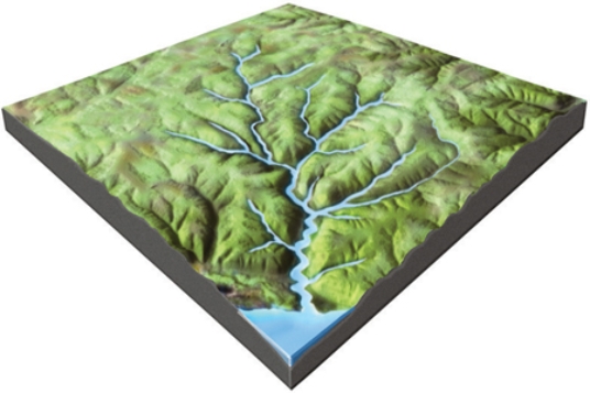
A)The rocks have a relatively equal resistance to erosion.
B)Drainages have followed a series of fractures that branch off of one another.
C)The area has folded or faulted rocks with different resistances to erosion.
D)A volcano once existed here but has been partly eroded away.
A)The rocks have a relatively equal resistance to erosion.
B)Drainages have followed a series of fractures that branch off of one another.
C)The area has folded or faulted rocks with different resistances to erosion.
D)A volcano once existed here but has been partly eroded away.
Question
Question
Question
Question
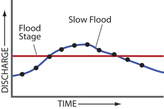
What is the pattern of discharge shown by this hydrograph? 
A)Discharge gradually increases and quickly decreases.
B)Discharge quickly increases and gradually decreases.
C)Discharge gradually decreases and quickly increases.
D)Discharges quickly decreases and gradually increases.
A)Discharge gradually increases and quickly decreases.
B)Discharge quickly increases and gradually decreases.
C)Discharge gradually decreases and quickly increases.
D)Discharges quickly decreases and gradually increases.
Question
Question
Based on the accompanying hydrograph, what was the stream discharge when the data period shown in the graph ended? 
A)1.8 meters per second
B)4 meters per second
C)4 cubic meters per second
D)9 cubic meters per second
E)10 cubic meters per second
A)1.8 meters per second
B)4 meters per second
C)4 cubic meters per second
D)9 cubic meters per second
E)10 cubic meters per second
Question
Question
Which event is best represented by the hydrograph shown here? 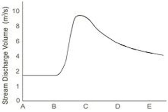
A)a summer thunderstorm
B)a very long period of steady light rain
C)a long drought with no rain for months
D)a winter snowstorm followed by very cold weather
A)a summer thunderstorm
B)a very long period of steady light rain
C)a long drought with no rain for months
D)a winter snowstorm followed by very cold weather
Question
Question
Compared with curve 2 on this hydrograph, what is a possible explanation for curve 1? 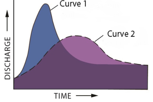
A)the basin for curve 1 has steeper slopes than the basin for curve 2
B)the storm recorded by curve 1 was shorter and more intense than the storm represented by curve 2
C)curve 1 shows the same area as curve 2 but after urbanization
D)All of these are possible.
A)the basin for curve 1 has steeper slopes than the basin for curve 2
B)the storm recorded by curve 1 was shorter and more intense than the storm represented by curve 2
C)curve 1 shows the same area as curve 2 but after urbanization
D)All of these are possible.
Question
Question
Question
Question
Question
What is a reasonable interpretation for the flow event recorded by this hydrograph? 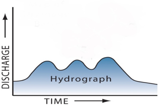
A)there were two pulses of runoff because there were two storms
B)the drainage basin has several distinct parts
C)one pulse could be due to snowmelt and the other to rain
D)All of these.
A)there were two pulses of runoff because there were two storms
B)the drainage basin has several distinct parts
C)one pulse could be due to snowmelt and the other to rain
D)All of these.
Question
What units of measure would most likely be represented by letters A-E on the bottom of the accompanying hydrograph? 
A)meters
B)hours
C)kilograms
D)miles
A)meters
B)hours
C)kilograms
D)miles
Question
What typically happens when tributaries join the main river? 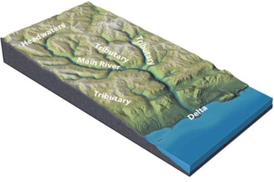
A)channel size increases
B)water velocity increases
C)the amount of discharge increases
D)total sediment load increases
E)All of these.
A)channel size increases
B)water velocity increases
C)the amount of discharge increases
D)total sediment load increases
E)All of these.
Question
What is the mostly likely setting for this drainage pattern? 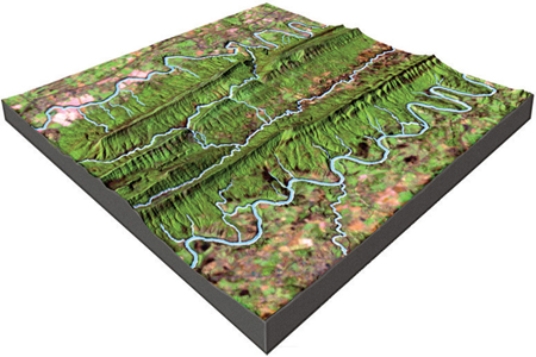
A)The rocks have a relatively equal resistance to erosion.
B)Drainages have followed a series of fractures that branch off of one another.
C)The area has folded or faulted rocks with different resistances to erosion.
D)A volcano once existed here but has been partly eroded away.
A)The rocks have a relatively equal resistance to erosion.
B)Drainages have followed a series of fractures that branch off of one another.
C)The area has folded or faulted rocks with different resistances to erosion.
D)A volcano once existed here but has been partly eroded away.
Question
In this diagram, water velocity downstream generally 
A)decreases.
B)remains the same.
C)increases.
D)There is no way to tell because discharge cannot be determined.
A)decreases.
B)remains the same.
C)increases.
D)There is no way to tell because discharge cannot be determined.
Question
At which sites would this stream profile most likely be located? 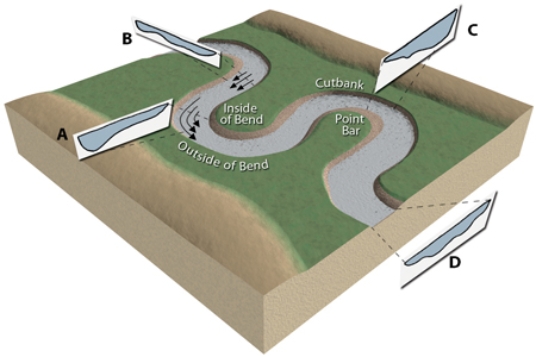
A)A and C
B)B and D
C)C and D
D)D and A
A)A and C
B)B and D
C)C and D
D)D and A
Question
Question
Question
Which site along this stream would have the highest velocity for that segment of the stream? 
A)A
B)B
C)C
D)D
A)A
B)B
C)C
D)D
Question
What happens to a river as it flows through a delta and encounters the sea? 
A)The discharge and water velocity increase.
B)The maximum sediment grain size carried by the river increases.
C)The total sediment load carried by the river decreases.
D)All of these.
A)The discharge and water velocity increase.
B)The maximum sediment grain size carried by the river increases.
C)The total sediment load carried by the river decreases.
D)All of these.
Question
Question
What could cause a canyon to be deeper upstream than downstream? 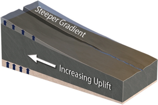
A)The area upstream could be uplifted more than areas downstream.
B)The area upstream is higher above base level and so results in deep erosion.
C)A steeper gradient allows more erosion upstream.
D)All of these.
A)The area upstream could be uplifted more than areas downstream.
B)The area upstream is higher above base level and so results in deep erosion.
C)A steeper gradient allows more erosion upstream.
D)All of these.
Question
On this graph of discharge versus season for a river in the Rocky Mountains, why is the highest runoff likely to be in the spring? 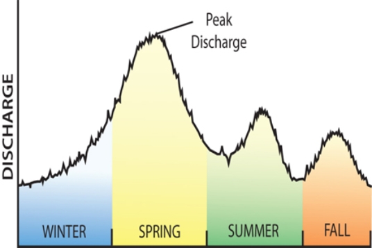
A)Winter snow melts in the spring.
B)The Rocky Mountains have many tornadoes during the spring.
C)The Rocky Mountains experience hurricanes in the spring.
D)All of these.
A)Winter snow melts in the spring.
B)The Rocky Mountains have many tornadoes during the spring.
C)The Rocky Mountains experience hurricanes in the spring.
D)All of these.
Question
Question
At which site along this stream would a cut bank form? 
A)A
B)B
C)C
D)D
A)A
B)B
C)C
D)D
Question
Question
What could cause this stream to begin carving into the landscape? 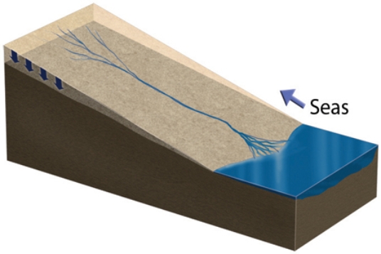
A)if base level is lowered, such as a drop in sea level
B)if the land is uplifted relative to the sea
C)if a change in climate weathers and weakens the rocks
D)All of these.
A)if base level is lowered, such as a drop in sea level
B)if the land is uplifted relative to the sea
C)if a change in climate weathers and weakens the rocks
D)All of these.
Question
Question
Question
Which of the following profiles does NOT match its position on the stream? 
A)A
B)B
C)C
D)D
A)A
B)B
C)C
D)D
Question
Question
Which of the lettered sites would most likely be undercut by migration of a meander? 
A)A
B)B
C)C
D)D
A)A
B)B
C)C
D)D
Question
At which site along this stream would a point bar form? 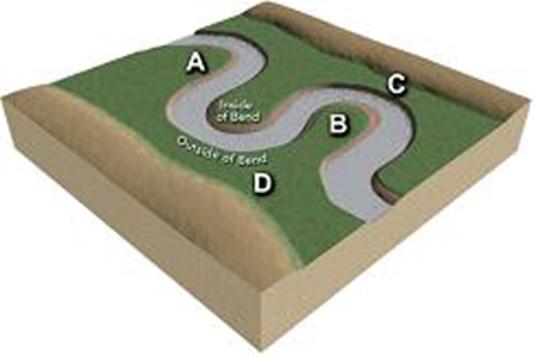
A)A
B)B
C)C
D)D
A)A
B)B
C)C
D)D
Question
Question
What does the associated graph indicate about a stream? 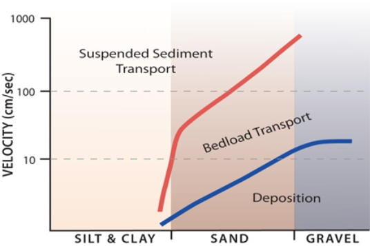
A)Silt and clay are carried in suspension under most stream velocities.
B)Sand and gravel are deposited at low velocities but transported at higher velocities.
C)Sand is carried in suspension only at high velocities.
D)As fast-moving water slows down, fine sand can switch from transport by suspension to the bed load.
E)All of these.
Question
Which of the features on this aerial photograph is a point bar? 
A)A
B)B
C)C
D)D
A)A
B)B
C)C
D)D
Question
Question
What type of stream is shown in this figure? 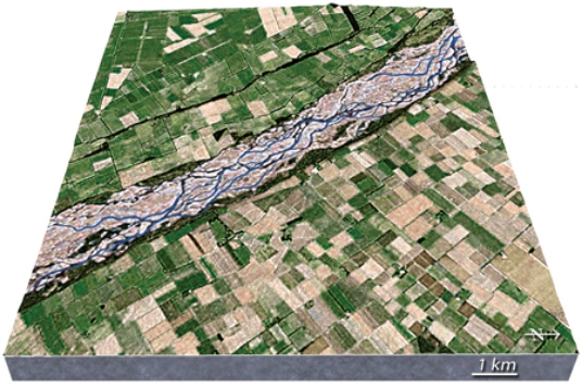
A)meandering stream
B)braided stream
C)a stream whose main channel has high sinuosity
D)an esker
A)meandering stream
B)braided stream
C)a stream whose main channel has high sinuosity
D)an esker
Question
Question
What type of stream is shown in this figure? 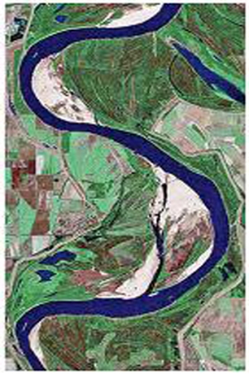
A)braided stream
B)a stream whose channel has a low sinuosity
C)meandering stream
D)a stream that lacks point bars
E)All of these.
A)braided stream
B)a stream whose channel has a low sinuosity
C)meandering stream
D)a stream that lacks point bars
E)All of these.
Question
Which of the features on this aerial photograph is a cutbank? 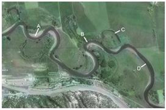
A)A
B)B
C)C
D)D
A)A
B)B
C)C
D)D
Question
Feature A, formed where the Nile River encounters the Mediterranean Sea, is 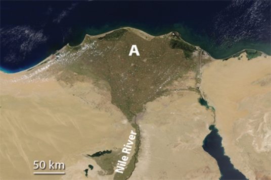
A)a landslide.
B)a series of waterfalls.
C)a delta.
D)All of these.
A)a landslide.
B)a series of waterfalls.
C)a delta.
D)All of these.
Question
Question
Question
Which of the features on this aerial photograph is an oxbow lake? 
A)A
B)B
C)C
D)D
A)A
B)B
C)C
D)D
Question
Construction of a dam results in 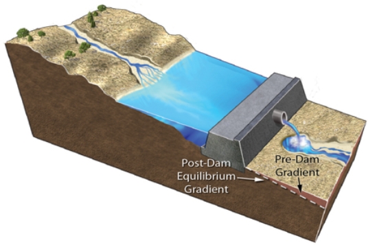
A)an increase in the total amount of water flowing downstream of the dam.
B)increased erosion by clear water released from the dam.
C)the dam releasing water that contains more sediment than carried by the river before the dam was constructed.
D)increased erosion where the stream channel meets the reservoir.
Question
Question
Question
What type of stream is shown in this photograph? 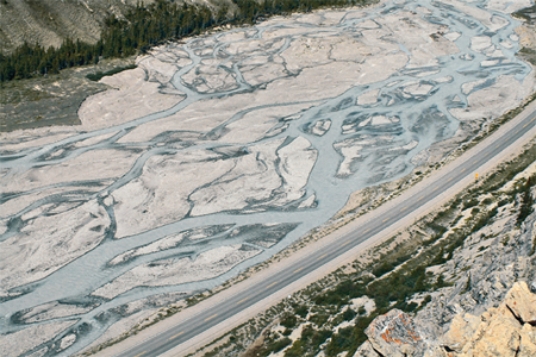
A)meandering stream
B)braided stream
C)a stream whose main channel has high sinuosity
D)an esker
A)meandering stream
B)braided stream
C)a stream whose main channel has high sinuosity
D)an esker
Question
Question
Question
Question
Question
Question
Question
Question
Question
What would happen if the amount of ice in this area increases? 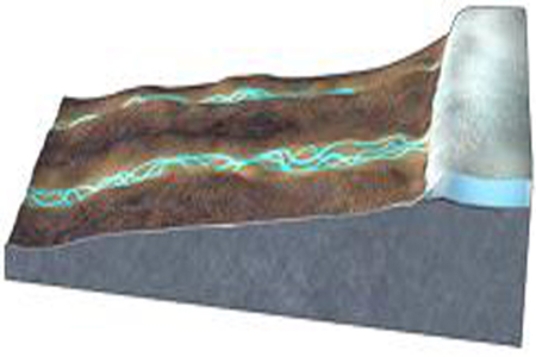
A)The land near the ice would rise.
B)The area near the ice would experience isostatic rebound.
C)The weight of the ice depresses the land, possibly causing river to change direction.
D)None of these.
A)The land near the ice would rise.
B)The area near the ice would experience isostatic rebound.
C)The weight of the ice depresses the land, possibly causing river to change direction.
D)None of these.
Question
This figure shows four numbered river terraces, with 1 being the highest and 4 being the lowest.Which is the oldest terrace? 
A)1
B)2
C)3
D)4
A)1
B)2
C)3
D)4
Question
Question
The type of feature shown in this figure is 
A)a braided stream.
B)river terraces.
C)alluvial fans.
D)entrenched meanders.
E)None of these.
A)a braided stream.
B)river terraces.
C)alluvial fans.
D)entrenched meanders.
E)None of these.
Question
Question
Question
Question
This figure shows four numbered river terraces, with 1 being the highest and 4 being the lowest.Which is the youngest terrace? 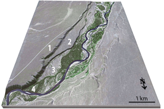
A)1
B)2
C)3
D)4
A)1
B)2
C)3
D)4
Question
What would happen if the ice in this area melted away? 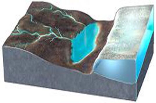
A)The land near the ice would drop due to isostatic rebound.
B)Rivers could change direction and flow away from the area once covered by ice.
C)The land subsides because the ice is removed.
D)All of these.
A)The land near the ice would drop due to isostatic rebound.
B)Rivers could change direction and flow away from the area once covered by ice.
C)The land subsides because the ice is removed.
D)All of these.
Question
What can you conclude by comparing the left and right hydrographs, each of which depict the same amount of time? 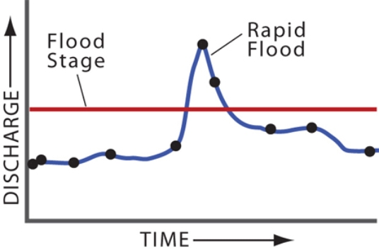
A)The left diagram has a higher peak discharge.
B)The right diagram represents a quicker event, like a flash flood.
C)Neither graph shows a true flood.
D)None of these.
A)The left diagram has a higher peak discharge.
B)The right diagram represents a quicker event, like a flash flood.
C)Neither graph shows a true flood.
D)None of these.
Question
Question
How did the entrenched meanders shown in this figure form? 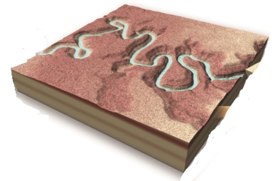
A)Rising seas flooded a meandering river valley.
B)The land subsided and the river deposited sediment.
C)A meandering river carved into the land due to uplift or falling base level.
D)None of these.
A)Rising seas flooded a meandering river valley.
B)The land subsided and the river deposited sediment.
C)A meandering river carved into the land due to uplift or falling base level.
D)None of these.
Question
Question
Question
Question
Question
Question

Unlock Deck
Sign up to unlock the cards in this deck!
Unlock Deck
Unlock Deck
1/95
Play
Full screen (f)
Deck 13: Streams and Flooding
1
What is the mostly likely setting for this drainage pattern?
A)The rocks have a relatively equal resistance to erosion.
B)Drainages have followed a series of fractures that branch off of one another.
C)The area has folded or faulted rocks with different resistances to erosion.
D)A volcano once existed here but has been partly eroded away.
A)The rocks have a relatively equal resistance to erosion.
B)Drainages have followed a series of fractures that branch off of one another.
C)The area has folded or faulted rocks with different resistances to erosion.
D)A volcano once existed here but has been partly eroded away.
A
2
Which of the following is a condition favoring deposition of sediment?
A)an increase in water velocity
B)a decrease in gradient of the stream
C)an increase in turbulence of the water
D)an increase in the salt content of the water
E)a decrease in grain size as a clast breaks into two pieces
A)an increase in water velocity
B)a decrease in gradient of the stream
C)an increase in turbulence of the water
D)an increase in the salt content of the water
E)a decrease in grain size as a clast breaks into two pieces
B
3
Which of the following is true about how a stream erodes material?
A)Abrasion is concentrated on the upstream side of obstructions.
B)Turbulence of the water is less important than the temperature, which affects viscosity.
C)Erosion occurs equally on two sides of a bend.
D)Water cannot erode unless it is carrying sediment.
E)All of these.
A)Abrasion is concentrated on the upstream side of obstructions.
B)Turbulence of the water is less important than the temperature, which affects viscosity.
C)Erosion occurs equally on two sides of a bend.
D)Water cannot erode unless it is carrying sediment.
E)All of these.
A
4
If erosion and deposition occur at the same rate, how can we best describe the particles of sediment on a streambed?
A)Only very small particles will be present along the stream bottom.
B)Particles neither move in, nor move out of this part of the stream.
C)As the sediment moves downstream, it is replaced by a similar volume of sediment.
D)Pebbles and cobbles carried away are replaced by the same number of smaller particles.
Unlock Deck
Unlock for access to all 95 flashcards in this deck.
Unlock Deck
k this deck
5
What is the pattern of discharge shown by this hydrograph?
A)Discharge gradually increases and quickly decreases.
B)Discharge quickly increases and gradually decreases.
C)Discharge gradually decreases and quickly increases.
D)Discharges quickly decreases and gradually increases.
A)Discharge gradually increases and quickly decreases.
B)Discharge quickly increases and gradually decreases.
C)Discharge gradually decreases and quickly increases.
D)Discharges quickly decreases and gradually increases.
Unlock Deck
Unlock for access to all 95 flashcards in this deck.
Unlock Deck
k this deck
6
Which of the following is true about transport of sediment in a stream?
A)Pebbles and cobbles are mostly transported by suspension.
B)Sediment that is deposited within a stream bed is unlikely to be transported again.
C)Sand can be transported in a series of bounces along the stream bed.
D)Slower current can carry larger clasts because the water is in contact with each clast for a longer time.
E)Sand grains are converted into salt by the process of saltation.
Unlock Deck
Unlock for access to all 95 flashcards in this deck.
Unlock Deck
k this deck
7
Based on the accompanying hydrograph, what was the stream discharge when the data period shown in the graph ended?
A)1.8 meters per second
B)4 meters per second
C)4 cubic meters per second
D)9 cubic meters per second
E)10 cubic meters per second
A)1.8 meters per second
B)4 meters per second
C)4 cubic meters per second
D)9 cubic meters per second
E)10 cubic meters per second
Unlock Deck
Unlock for access to all 95 flashcards in this deck.
Unlock Deck
k this deck
8
A delta forms when
A)ocean waves, especially during storms, pile up sediment along the coast.
B)a steep mountain front collapses sending sediment out into the sea.
C)a river slows and deposits sediment as it enters a lake or sea.
D)windblown dust slides down steep hillsides and into a lake.
A)ocean waves, especially during storms, pile up sediment along the coast.
B)a steep mountain front collapses sending sediment out into the sea.
C)a river slows and deposits sediment as it enters a lake or sea.
D)windblown dust slides down steep hillsides and into a lake.
Unlock Deck
Unlock for access to all 95 flashcards in this deck.
Unlock Deck
k this deck
9
Which event is best represented by the hydrograph shown here?
A)a summer thunderstorm
B)a very long period of steady light rain
C)a long drought with no rain for months
D)a winter snowstorm followed by very cold weather
A)a summer thunderstorm
B)a very long period of steady light rain
C)a long drought with no rain for months
D)a winter snowstorm followed by very cold weather
Unlock Deck
Unlock for access to all 95 flashcards in this deck.
Unlock Deck
k this deck
10
Bedrock and sediment in a stream is most susceptible to erosion if it is
A)in slow-moving water in an eddy.
B)in a site that is sheltered from oncoming clasts.
C)located in a turbulent part of the river.
D)composed entirely of large clasts that affect stream flow.
E)All of these.
A)in slow-moving water in an eddy.
B)in a site that is sheltered from oncoming clasts.
C)located in a turbulent part of the river.
D)composed entirely of large clasts that affect stream flow.
E)All of these.
Unlock Deck
Unlock for access to all 95 flashcards in this deck.
Unlock Deck
k this deck
11
Compared with curve 2 on this hydrograph, what is a possible explanation for curve 1?
A)the basin for curve 1 has steeper slopes than the basin for curve 2
B)the storm recorded by curve 1 was shorter and more intense than the storm represented by curve 2
C)curve 1 shows the same area as curve 2 but after urbanization
D)All of these are possible.
A)the basin for curve 1 has steeper slopes than the basin for curve 2
B)the storm recorded by curve 1 was shorter and more intense than the storm represented by curve 2
C)curve 1 shows the same area as curve 2 but after urbanization
D)All of these are possible.
Unlock Deck
Unlock for access to all 95 flashcards in this deck.
Unlock Deck
k this deck
12
The size of clasts that a stream can carry is primarily controlled by
A)the water temperature.
B)the amount of dissolved and suspended load of a stream.
C)how close the stream is to the ocean.
D)the velocity and turbulence of the current.
E)whether it is a permanent or ephemeral stream.
A)the water temperature.
B)the amount of dissolved and suspended load of a stream.
C)how close the stream is to the ocean.
D)the velocity and turbulence of the current.
E)whether it is a permanent or ephemeral stream.
Unlock Deck
Unlock for access to all 95 flashcards in this deck.
Unlock Deck
k this deck
13
Which of the following does NOT influence whether sediment is picked up by a stream?
A)size and density of the sediment
B)turbulence of the moving water
C)location of the sediment in the stream
D)whether the stream flows north-south or east-west
A)size and density of the sediment
B)turbulence of the moving water
C)location of the sediment in the stream
D)whether the stream flows north-south or east-west
Unlock Deck
Unlock for access to all 95 flashcards in this deck.
Unlock Deck
k this deck
14
Which of the following sediment sizes is likely to be transported mostly on the bottom of the stream bed?
A)fine sand
B)sticky clay particles
C)pebbles and cobbles
D)dissolved materials
A)fine sand
B)sticky clay particles
C)pebbles and cobbles
D)dissolved materials
Unlock Deck
Unlock for access to all 95 flashcards in this deck.
Unlock Deck
k this deck
15
Which particles of sediment are most likely to be transported as suspended load?
A)small, low density particles
B)pebbles of average density
C)sand and gravel of relatively high density
D)dissolved ions in solution
E)All of these.
A)small, low density particles
B)pebbles of average density
C)sand and gravel of relatively high density
D)dissolved ions in solution
E)All of these.
Unlock Deck
Unlock for access to all 95 flashcards in this deck.
Unlock Deck
k this deck
16
What is a reasonable interpretation for the flow event recorded by this hydrograph?
A)there were two pulses of runoff because there were two storms
B)the drainage basin has several distinct parts
C)one pulse could be due to snowmelt and the other to rain
D)All of these.
A)there were two pulses of runoff because there were two storms
B)the drainage basin has several distinct parts
C)one pulse could be due to snowmelt and the other to rain
D)All of these.
Unlock Deck
Unlock for access to all 95 flashcards in this deck.
Unlock Deck
k this deck
17
What units of measure would most likely be represented by letters A-E on the bottom of the accompanying hydrograph?
A)meters
B)hours
C)kilograms
D)miles
A)meters
B)hours
C)kilograms
D)miles
Unlock Deck
Unlock for access to all 95 flashcards in this deck.
Unlock Deck
k this deck
18
What typically happens when tributaries join the main river?
A)channel size increases
B)water velocity increases
C)the amount of discharge increases
D)total sediment load increases
E)All of these.
A)channel size increases
B)water velocity increases
C)the amount of discharge increases
D)total sediment load increases
E)All of these.
Unlock Deck
Unlock for access to all 95 flashcards in this deck.
Unlock Deck
k this deck
19
What is the mostly likely setting for this drainage pattern?
A)The rocks have a relatively equal resistance to erosion.
B)Drainages have followed a series of fractures that branch off of one another.
C)The area has folded or faulted rocks with different resistances to erosion.
D)A volcano once existed here but has been partly eroded away.
A)The rocks have a relatively equal resistance to erosion.
B)Drainages have followed a series of fractures that branch off of one another.
C)The area has folded or faulted rocks with different resistances to erosion.
D)A volcano once existed here but has been partly eroded away.
Unlock Deck
Unlock for access to all 95 flashcards in this deck.
Unlock Deck
k this deck
20
In this diagram, water velocity downstream generally
A)decreases.
B)remains the same.
C)increases.
D)There is no way to tell because discharge cannot be determined.
A)decreases.
B)remains the same.
C)increases.
D)There is no way to tell because discharge cannot be determined.
Unlock Deck
Unlock for access to all 95 flashcards in this deck.
Unlock Deck
k this deck
21
At which sites would this stream profile most likely be located?
A)A and C
B)B and D
C)C and D
D)D and A
A)A and C
B)B and D
C)C and D
D)D and A
Unlock Deck
Unlock for access to all 95 flashcards in this deck.
Unlock Deck
k this deck
22
If a river originates 200 meters above sea level and travels 100 kilometers to the ocean, what is the average gradient in meters per kilometer?
A)0.2 meters per kilometer
B)0.5 meters per kilometer
C)2 meters per kilometer
D)5 meters per kilometer
E)None of these.
A)0.2 meters per kilometer
B)0.5 meters per kilometer
C)2 meters per kilometer
D)5 meters per kilometer
E)None of these.
Unlock Deck
Unlock for access to all 95 flashcards in this deck.
Unlock Deck
k this deck
23
Which of the following can influence a stream's profile?
A)a rise in sea level
B)a fall in sea level
C)tectonics
D)All of these.
A)a rise in sea level
B)a fall in sea level
C)tectonics
D)All of these.
Unlock Deck
Unlock for access to all 95 flashcards in this deck.
Unlock Deck
k this deck
24
Which site along this stream would have the highest velocity for that segment of the stream?
A)A
B)B
C)C
D)D
A)A
B)B
C)C
D)D
Unlock Deck
Unlock for access to all 95 flashcards in this deck.
Unlock Deck
k this deck
25
What happens to a river as it flows through a delta and encounters the sea?
A)The discharge and water velocity increase.
B)The maximum sediment grain size carried by the river increases.
C)The total sediment load carried by the river decreases.
D)All of these.
A)The discharge and water velocity increase.
B)The maximum sediment grain size carried by the river increases.
C)The total sediment load carried by the river decreases.
D)All of these.
Unlock Deck
Unlock for access to all 95 flashcards in this deck.
Unlock Deck
k this deck
26
Which of the following is true about the formation and migration of meanders?
A)most floodplains do not preserve evidence of the former position of meanders
B)flow velocity is highest when water takes a shortcut around the inside of a bend
C)meanders migrate inward as sediment is deposited on the inside bend
D)migration of meanders back and forth can help form a floodplain
E)None of these.
Unlock Deck
Unlock for access to all 95 flashcards in this deck.
Unlock Deck
k this deck
27
What could cause a canyon to be deeper upstream than downstream?
A)The area upstream could be uplifted more than areas downstream.
B)The area upstream is higher above base level and so results in deep erosion.
C)A steeper gradient allows more erosion upstream.
D)All of these.
A)The area upstream could be uplifted more than areas downstream.
B)The area upstream is higher above base level and so results in deep erosion.
C)A steeper gradient allows more erosion upstream.
D)All of these.
Unlock Deck
Unlock for access to all 95 flashcards in this deck.
Unlock Deck
k this deck
28
On this graph of discharge versus season for a river in the Rocky Mountains, why is the highest runoff likely to be in the spring?
A)Winter snow melts in the spring.
B)The Rocky Mountains have many tornadoes during the spring.
C)The Rocky Mountains experience hurricanes in the spring.
D)All of these.
A)Winter snow melts in the spring.
B)The Rocky Mountains have many tornadoes during the spring.
C)The Rocky Mountains experience hurricanes in the spring.
D)All of these.
Unlock Deck
Unlock for access to all 95 flashcards in this deck.
Unlock Deck
k this deck
29
Which of the following is NOT a common site for deposition of sediment?
A)point bar
B)distributary system
C)levee
D)cutbank
E)floodplain
A)point bar
B)distributary system
C)levee
D)cutbank
E)floodplain
Unlock Deck
Unlock for access to all 95 flashcards in this deck.
Unlock Deck
k this deck
30
At which site along this stream would a cut bank form?
A)A
B)B
C)C
D)D
A)A
B)B
C)C
D)D
Unlock Deck
Unlock for access to all 95 flashcards in this deck.
Unlock Deck
k this deck
31
What does a profile of a river from its headwaters to its mouth typically show?
A)an increase in gradient downstream
B)a straight-line profile reflecting a constant decrease in gradient
C)an abrupt increase followed by a gradual decrease
D)a curved shape that flattens out downstream
E)None of these.
A)an increase in gradient downstream
B)a straight-line profile reflecting a constant decrease in gradient
C)an abrupt increase followed by a gradual decrease
D)a curved shape that flattens out downstream
E)None of these.
Unlock Deck
Unlock for access to all 95 flashcards in this deck.
Unlock Deck
k this deck
32
What could cause this stream to begin carving into the landscape?
A)if base level is lowered, such as a drop in sea level
B)if the land is uplifted relative to the sea
C)if a change in climate weathers and weakens the rocks
D)All of these.
A)if base level is lowered, such as a drop in sea level
B)if the land is uplifted relative to the sea
C)if a change in climate weathers and weakens the rocks
D)All of these.
Unlock Deck
Unlock for access to all 95 flashcards in this deck.
Unlock Deck
k this deck
33
Which of the following is unlikely to cause deposition of sediment along a stream?
A)a decrease in gradient
B)a decrease in water velocity
C)a drop in sea level
D)None of these.
A)a decrease in gradient
B)a decrease in water velocity
C)a drop in sea level
D)None of these.
Unlock Deck
Unlock for access to all 95 flashcards in this deck.
Unlock Deck
k this deck
34
Which of the following is true about the base level of a stream?
A)Base level indicates the normal (or base)flow level before flooding.
B)The flat top of a mountain is the ultimate base level for most streams.
C)A mountain is close to its base level if bedrock is close to the surface.
D)Most streams have lower gradient close to their base level.
E)Base level generally is near the steepest part of a stream's profile.
Unlock Deck
Unlock for access to all 95 flashcards in this deck.
Unlock Deck
k this deck
35
Which of the following profiles does NOT match its position on the stream?
A)A
B)B
C)C
D)D
A)A
B)B
C)C
D)D
Unlock Deck
Unlock for access to all 95 flashcards in this deck.
Unlock Deck
k this deck
36
If a stream drops 15 meters in 15 kilometers, what is its gradient?
A)100%
B)1 meter per kilometer
C)15 meters per kilometer
D)15 kilometers per meter
E)None of these.
A)100%
B)1 meter per kilometer
C)15 meters per kilometer
D)15 kilometers per meter
E)None of these.
Unlock Deck
Unlock for access to all 95 flashcards in this deck.
Unlock Deck
k this deck
37
Which of the lettered sites would most likely be undercut by migration of a meander?
A)A
B)B
C)C
D)D
A)A
B)B
C)C
D)D
Unlock Deck
Unlock for access to all 95 flashcards in this deck.
Unlock Deck
k this deck
38
At which site along this stream would a point bar form?
A)A
B)B
C)C
D)D
A)A
B)B
C)C
D)D
Unlock Deck
Unlock for access to all 95 flashcards in this deck.
Unlock Deck
k this deck
39
Which of the following typically decreases downstream in a river?
A)flow velocity
B)discharge
C)channel size
D)maximum sediment grain size
E)None of these.
A)flow velocity
B)discharge
C)channel size
D)maximum sediment grain size
E)None of these.
Unlock Deck
Unlock for access to all 95 flashcards in this deck.
Unlock Deck
k this deck
40
What does the associated graph indicate about a stream?
A)Silt and clay are carried in suspension under most stream velocities.
B)Sand and gravel are deposited at low velocities but transported at higher velocities.
C)Sand is carried in suspension only at high velocities.
D)As fast-moving water slows down, fine sand can switch from transport by suspension to the bed load.
E)All of these.
Unlock Deck
Unlock for access to all 95 flashcards in this deck.
Unlock Deck
k this deck
41
Which of the features on this aerial photograph is a point bar?
A)A
B)B
C)C
D)D
A)A
B)B
C)C
D)D
Unlock Deck
Unlock for access to all 95 flashcards in this deck.
Unlock Deck
k this deck
42
If a stream-cut canyon is deep and narrow, which of the following is most likely to be true?
A)Rocks in the canyon walls are relatively hard and easy to erode.
B)The stream is probably close to its base level.
C)Downcutting is occurring faster than widening.
D)The stream contains mostly small clasts, such as silt.
A)Rocks in the canyon walls are relatively hard and easy to erode.
B)The stream is probably close to its base level.
C)Downcutting is occurring faster than widening.
D)The stream contains mostly small clasts, such as silt.
Unlock Deck
Unlock for access to all 95 flashcards in this deck.
Unlock Deck
k this deck
43
What type of stream is shown in this figure?
A)meandering stream
B)braided stream
C)a stream whose main channel has high sinuosity
D)an esker
A)meandering stream
B)braided stream
C)a stream whose main channel has high sinuosity
D)an esker
Unlock Deck
Unlock for access to all 95 flashcards in this deck.
Unlock Deck
k this deck
44
Where do mountain streams get most of their load of sediment?
A)landslides, slope failures, and erosion of the mountain sides
B)downward incision into bedrock
C)abrasion of bedrock along the bottom of the channel
D)alluvial fans
A)landslides, slope failures, and erosion of the mountain sides
B)downward incision into bedrock
C)abrasion of bedrock along the bottom of the channel
D)alluvial fans
Unlock Deck
Unlock for access to all 95 flashcards in this deck.
Unlock Deck
k this deck
45
What type of stream is shown in this figure?
A)braided stream
B)a stream whose channel has a low sinuosity
C)meandering stream
D)a stream that lacks point bars
E)All of these.
A)braided stream
B)a stream whose channel has a low sinuosity
C)meandering stream
D)a stream that lacks point bars
E)All of these.
Unlock Deck
Unlock for access to all 95 flashcards in this deck.
Unlock Deck
k this deck
46
Which of the features on this aerial photograph is a cutbank?
A)A
B)B
C)C
D)D
A)A
B)B
C)C
D)D
Unlock Deck
Unlock for access to all 95 flashcards in this deck.
Unlock Deck
k this deck
47
Feature A, formed where the Nile River encounters the Mediterranean Sea, is
A)a landslide.
B)a series of waterfalls.
C)a delta.
D)All of these.
A)a landslide.
B)a series of waterfalls.
C)a delta.
D)All of these.
Unlock Deck
Unlock for access to all 95 flashcards in this deck.
Unlock Deck
k this deck
48
Which of the following is NOT true about braided streams?
A)These streams form where the sediment is plentiful and dominated by clay and silt.
B)The amount of sediment is close to or exceeds the stream's capacity to carry it.
C)More than one channel can carry water and sediment.
D)They can have a fairly straight overall path or gentle curves.
A)These streams form where the sediment is plentiful and dominated by clay and silt.
B)The amount of sediment is close to or exceeds the stream's capacity to carry it.
C)More than one channel can carry water and sediment.
D)They can have a fairly straight overall path or gentle curves.
Unlock Deck
Unlock for access to all 95 flashcards in this deck.
Unlock Deck
k this deck
49
Which of the following features is NOT formed by stream deposition?
A)broad plains next to a braided stream
B)a floodplain
C)a delta
D)a waterfall
A)broad plains next to a braided stream
B)a floodplain
C)a delta
D)a waterfall
Unlock Deck
Unlock for access to all 95 flashcards in this deck.
Unlock Deck
k this deck
50
Which of the features on this aerial photograph is an oxbow lake?
A)A
B)B
C)C
D)D
A)A
B)B
C)C
D)D
Unlock Deck
Unlock for access to all 95 flashcards in this deck.
Unlock Deck
k this deck
51
Construction of a dam results in
A)an increase in the total amount of water flowing downstream of the dam.
B)increased erosion by clear water released from the dam.
C)the dam releasing water that contains more sediment than carried by the river before the dam was constructed.
D)increased erosion where the stream channel meets the reservoir.
Unlock Deck
Unlock for access to all 95 flashcards in this deck.
Unlock Deck
k this deck
52
Which of the following features can be formed by deposition along a low-gradient stream?
A)point bar
B)oxbow lake
C)cutbank
D)None of these.
A)point bar
B)oxbow lake
C)cutbank
D)None of these.
Unlock Deck
Unlock for access to all 95 flashcards in this deck.
Unlock Deck
k this deck
53
Which of the following is commonly associated with tributaries?
A)rapids when the tributary joins the main river
B)delivery of sediment to the main river
C)an increase in the discharge in the main river
D)All of these.
A)rapids when the tributary joins the main river
B)delivery of sediment to the main river
C)an increase in the discharge in the main river
D)All of these.
Unlock Deck
Unlock for access to all 95 flashcards in this deck.
Unlock Deck
k this deck
54
What type of stream is shown in this photograph?
A)meandering stream
B)braided stream
C)a stream whose main channel has high sinuosity
D)an esker
A)meandering stream
B)braided stream
C)a stream whose main channel has high sinuosity
D)an esker
Unlock Deck
Unlock for access to all 95 flashcards in this deck.
Unlock Deck
k this deck
55
Which of the following statements about streams is NOT true?
A)Base level is the lowest elevation to which a stream can erode.
B)A steep stream high above base level generally will be eroding its channel.
C)Some streams can simply transport material instead of eroding or depositing material.
D)Streams typically do not respond to a change in climate.
A)Base level is the lowest elevation to which a stream can erode.
B)A steep stream high above base level generally will be eroding its channel.
C)Some streams can simply transport material instead of eroding or depositing material.
D)Streams typically do not respond to a change in climate.
Unlock Deck
Unlock for access to all 95 flashcards in this deck.
Unlock Deck
k this deck
56
Which of the following is NOT associated with braided streams?
A)an abundant supply of sediment
B)a broad sediment-covered plain
C)a range of sediment sizes, including sand and gravel
D)cutoff meanders
A)an abundant supply of sediment
B)a broad sediment-covered plain
C)a range of sediment sizes, including sand and gravel
D)cutoff meanders
Unlock Deck
Unlock for access to all 95 flashcards in this deck.
Unlock Deck
k this deck
57
Which of the following features is most related to erosion along a low-gradient stream?
A)point bar
B)floodplain
C)levee
D)None of these.
A)point bar
B)floodplain
C)levee
D)None of these.
Unlock Deck
Unlock for access to all 95 flashcards in this deck.
Unlock Deck
k this deck
58
When water in a stream or desert wash decreases in velocity, sediment that the stream carries can be deposited in
A)a delta.
B)an alluvial fan.
C)a floodplain.
D)All of these.
A)a delta.
B)an alluvial fan.
C)a floodplain.
D)All of these.
Unlock Deck
Unlock for access to all 95 flashcards in this deck.
Unlock Deck
k this deck
59
How is an alluvial fan formed?
A)A stream erodes down through older terraces and entrenched meanders.
B)Sediment is deposited by debris flows and streams that decrease in velocity along the mountain front.
C)A landslide blocks the stream, causing sediment to accumulate upstream.
D)A dam increases the speed of currents below the dam.
Unlock Deck
Unlock for access to all 95 flashcards in this deck.
Unlock Deck
k this deck
60
Which of the following features are generally NOT associated with mountain streams and rivers?
A)waterfalls
B)rapids
C)canyons incised into bedrock
D)meanders
A)waterfalls
B)rapids
C)canyons incised into bedrock
D)meanders
Unlock Deck
Unlock for access to all 95 flashcards in this deck.
Unlock Deck
k this deck
61
Which of the following is true about a delta?
A)A delta forms as channels merge and pile up sand.
B)A river keeps forming a delta in the exact same position along a coastline.
C)Deltas form some layers that are horizontal and form some that are inclined toward the ocean.
D)The total amount of sediment carried by the river increases from the start to the end of the delta system.
Unlock Deck
Unlock for access to all 95 flashcards in this deck.
Unlock Deck
k this deck
62
Formation of entrenched meanders can result from a
A)low-gradient river followed by downcutting.
B)braided river that later exceeds its capacity to carry sediment.
C)braided river followed by regional uplift.
D)steep-gradient mountain stream following by an increase in precipitation.
A)low-gradient river followed by downcutting.
B)braided river that later exceeds its capacity to carry sediment.
C)braided river followed by regional uplift.
D)steep-gradient mountain stream following by an increase in precipitation.
Unlock Deck
Unlock for access to all 95 flashcards in this deck.
Unlock Deck
k this deck
63
What would happen if the amount of ice in this area increases?
A)The land near the ice would rise.
B)The area near the ice would experience isostatic rebound.
C)The weight of the ice depresses the land, possibly causing river to change direction.
D)None of these.
A)The land near the ice would rise.
B)The area near the ice would experience isostatic rebound.
C)The weight of the ice depresses the land, possibly causing river to change direction.
D)None of these.
Unlock Deck
Unlock for access to all 95 flashcards in this deck.
Unlock Deck
k this deck
64
This figure shows four numbered river terraces, with 1 being the highest and 4 being the lowest.Which is the oldest terrace?
A)1
B)2
C)3
D)4
A)1
B)2
C)3
D)4
Unlock Deck
Unlock for access to all 95 flashcards in this deck.
Unlock Deck
k this deck
65
Which of the following is the most common cause of river and stream flooding?
A)the onset of cold weather
B)failure of levees
C)intense precipitation
D)overgrazing
E)global warming
A)the onset of cold weather
B)failure of levees
C)intense precipitation
D)overgrazing
E)global warming
Unlock Deck
Unlock for access to all 95 flashcards in this deck.
Unlock Deck
k this deck
66
The type of feature shown in this figure is
A)a braided stream.
B)river terraces.
C)alluvial fans.
D)entrenched meanders.
E)None of these.
A)a braided stream.
B)river terraces.
C)alluvial fans.
D)entrenched meanders.
E)None of these.
Unlock Deck
Unlock for access to all 95 flashcards in this deck.
Unlock Deck
k this deck
67
Which of the following can have a significant effect on a river?
A)rises and drops in sea level
B)tectonics
C)types of bedrock in the river
D)changes in climate
E)All of these.
A)rises and drops in sea level
B)tectonics
C)types of bedrock in the river
D)changes in climate
E)All of these.
Unlock Deck
Unlock for access to all 95 flashcards in this deck.
Unlock Deck
k this deck
68
Which of the following is NOT true about rivers?
A)Major rivers, like the upper Mississippi near the Great Lakes, must be relatively old rivers.
B)The boundary between hard rocks and soft rocks can be marked by waterfalls.
C)Loading and unloading of the crust by ice sheets can change the direction that rivers flow.
D)Different parts of a river can be different ages.
Unlock Deck
Unlock for access to all 95 flashcards in this deck.
Unlock Deck
k this deck
69
What is NOT true about terraces?
A)Most terraces were once part of a floodplain.
B)According to superposition, the lowest terrace is the oldest.
C)Terraces develop along a river that is incising (eroding)downward.
D)A river can have more than one level of terraces.
A)Most terraces were once part of a floodplain.
B)According to superposition, the lowest terrace is the oldest.
C)Terraces develop along a river that is incising (eroding)downward.
D)A river can have more than one level of terraces.
Unlock Deck
Unlock for access to all 95 flashcards in this deck.
Unlock Deck
k this deck
70
This figure shows four numbered river terraces, with 1 being the highest and 4 being the lowest.Which is the youngest terrace?
A)1
B)2
C)3
D)4
A)1
B)2
C)3
D)4
Unlock Deck
Unlock for access to all 95 flashcards in this deck.
Unlock Deck
k this deck
71
What would happen if the ice in this area melted away?
A)The land near the ice would drop due to isostatic rebound.
B)Rivers could change direction and flow away from the area once covered by ice.
C)The land subsides because the ice is removed.
D)All of these.
A)The land near the ice would drop due to isostatic rebound.
B)Rivers could change direction and flow away from the area once covered by ice.
C)The land subsides because the ice is removed.
D)All of these.
Unlock Deck
Unlock for access to all 95 flashcards in this deck.
Unlock Deck
k this deck
72
What can you conclude by comparing the left and right hydrographs, each of which depict the same amount of time?
A)The left diagram has a higher peak discharge.
B)The right diagram represents a quicker event, like a flash flood.
C)Neither graph shows a true flood.
D)None of these.
A)The left diagram has a higher peak discharge.
B)The right diagram represents a quicker event, like a flash flood.
C)Neither graph shows a true flood.
D)None of these.
Unlock Deck
Unlock for access to all 95 flashcards in this deck.
Unlock Deck
k this deck
73
What are some effects of building a dam?
A)A stream has more sediment below the dam and so can erode more efficiently.
B)The reservoir (lake)traps sediment that over time fills up part of the reservoir.
C)A dam, whether constructed by nature or by humans, represents a permanent change in base level.
D)The stream erodes into the land instead of depositing sediment, where it enters the reservoir.
Unlock Deck
Unlock for access to all 95 flashcards in this deck.
Unlock Deck
k this deck
74
How did the entrenched meanders shown in this figure form?
A)Rising seas flooded a meandering river valley.
B)The land subsided and the river deposited sediment.
C)A meandering river carved into the land due to uplift or falling base level.
D)None of these.
A)Rising seas flooded a meandering river valley.
B)The land subsided and the river deposited sediment.
C)A meandering river carved into the land due to uplift or falling base level.
D)None of these.
Unlock Deck
Unlock for access to all 95 flashcards in this deck.
Unlock Deck
k this deck
75
Which of the following influences whether a flood occurs?
A)the height of levees
B)the amount of discharge
C)urbanization (replacing farms or natural land with buildings)
D)the width of the channel
E)All of these are influences.
A)the height of levees
B)the amount of discharge
C)urbanization (replacing farms or natural land with buildings)
D)the width of the channel
E)All of these are influences.
Unlock Deck
Unlock for access to all 95 flashcards in this deck.
Unlock Deck
k this deck
76
Which of the following is properly called a flood?
A)when a meander is cut off and forms a lake
B)when the entire bottom of the channel is covered with water
C)if water spreads out over the floodplain
D)when water is 1 meter below the top of the channel
A)when a meander is cut off and forms a lake
B)when the entire bottom of the channel is covered with water
C)if water spreads out over the floodplain
D)when water is 1 meter below the top of the channel
Unlock Deck
Unlock for access to all 95 flashcards in this deck.
Unlock Deck
k this deck
77
Which of the following accompanies urbanization (replacing farms and open areas with cities)?
A)The discharge pattern of streams in the area does not change.
B)Runoff occurs more quickly and produces a higher peak flow.
C)Runoff becomes more spread out in time, increasing the amount of flooding.
D)Runoff becomes more spread out in time, reducing the amount of flooding.
E)None of these.
A)The discharge pattern of streams in the area does not change.
B)Runoff occurs more quickly and produces a higher peak flow.
C)Runoff becomes more spread out in time, increasing the amount of flooding.
D)Runoff becomes more spread out in time, reducing the amount of flooding.
E)None of these.
Unlock Deck
Unlock for access to all 95 flashcards in this deck.
Unlock Deck
k this deck
78
Which of the following sites is most likely to be flooded if all other factors are held constant?
A)a site that is higher but closer to the river than a site that is lower but farther from the river
B)a site next to the river where the main channel is wider and deeper than other segments of the river
C)a site on the floodplain instead of a site on an older terrace
D)All of these.
A)a site that is higher but closer to the river than a site that is lower but farther from the river
B)a site next to the river where the main channel is wider and deeper than other segments of the river
C)a site on the floodplain instead of a site on an older terrace
D)All of these.
Unlock Deck
Unlock for access to all 95 flashcards in this deck.
Unlock Deck
k this deck
79
Which of the following is the main reason that a delta forms when a stream flows into a lake or sea?
A)The stream flows backward during high tide.
B)Ocean waves push the sediment up onto the beach.
C)The velocity of the stream decreases.
D)The stream began downcutting during the ice ages.
E)None of these.
A)The stream flows backward during high tide.
B)Ocean waves push the sediment up onto the beach.
C)The velocity of the stream decreases.
D)The stream began downcutting during the ice ages.
E)None of these.
Unlock Deck
Unlock for access to all 95 flashcards in this deck.
Unlock Deck
k this deck
80
Stream terraces represent
A)older floodplains of a river that has incised downward.
B)cutoff meanders of a meandering stream.
C)areas where sea level has risen and waves beveled across the coast.
D)None of these.
A)older floodplains of a river that has incised downward.
B)cutoff meanders of a meandering stream.
C)areas where sea level has risen and waves beveled across the coast.
D)None of these.
Unlock Deck
Unlock for access to all 95 flashcards in this deck.
Unlock Deck
k this deck
Unlock Deck
Unlock for access to all 95 flashcards in this deck.


