Multiple Choice
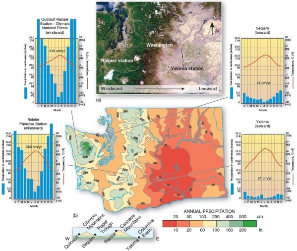 Orographic patterns in Washington State.Four stations in Washington provide examples of orographic effects: windward precipitation and leeward rain shadows.Isohyets (isolines of equal precipitation amounts) on the map indicate rainfall (in inches) .Note each station on the landscape profile at bottom.
In the state of Washington,the western portion of the state receives far more rainfall than the eastern portion of the state.What accounts for this stark contrast?
A) The western portion of the state sees a great deal of frontal lifting,while the eastern portion is under a high pressure cell.
B) The western portion of the state experiences orographic precipitation,while the eastern portion is in the rain shadow.
C) The western portion of the state has much more moderate temperatures due to the maritime effect and,therefore,experiences convectional uplift,while the eastern portion is governed by continentality.
D) The western portion of the state is under the ITCZ during the summer and experiences convergent uplift,while the eastern portion is under the Azores High and experiences subsiding air.
E) The western portion of the state experiences year-round convective rainstorms,whereas the eastern portion does not.
Correct Answer:

Verified
Correct Answer:
Verified
Q64: Examine the typical conditions that spawn hurricanes
Q65: Discuss the formation,physical characteristics,and typical precipitation patterns
Q66: Severe thunderstorms can produce strong downdrafts that
Q67: <img src="https://d2lvgg3v3hfg70.cloudfront.net/TB5538/.jpg" alt=" Tropical cyclone formation areas
Q68: Climate is<br>A)the weather of a region at
Q70: During the occluded stage of a midlatitude
Q71: Air masses which develop over Canada are
Q72: When a cold cP air mass passes
Q73: Which of the following is predicted to
Q74: Migrating centers of low pressure in the