Essay
Map Exercise 1-2
On the outline map of the world that follows and using the text as a reference, mark the following:
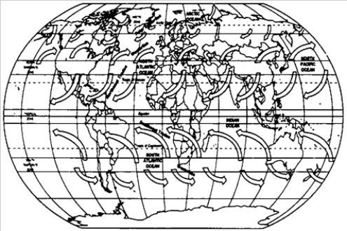
-Refer to Map Exercise 1-2. You will need five colors to complete this map exercise. Highlight pens will work fine.)
Trade winds Northeast and Southeast) blow from the Horse Latitudes toward the Equator. The rotation of Earth causes these winds to blow diagonally rather than directly North or South.
Westerlies blow from the Horse Latitudes toward the polar regions. The diagonal deflection of these winds is also caused by Earth's rotation.
Stagnant air exists in the Horse Latitudes and in the area called the Doldrums. The Horse Latitudes are so named because the Spanish, who frequently ferried horses across the Atlantic, often found their sailing vessels stalled in this region. As a result, they ran out of water for the horses. As the horses died from thirst, they had to be thrown overboard.)
Polar Easterlies blow from the Arctic regions toward the more temperate regions to the South.
Use one color to highlight the area in which the Doldrums are located. Label this area "The Doldrums." The Doldrums are located to the immediate north and south of the Equator, where the Northeast Trades and the Southeast Trades meet.)
Use a second color to highlight the Trade winds, both Northeast and Southeast.
Use a third color to highlight the areas in which the Horse Latitudes are located. Label this area "The Horse Latitudes." The Horse Latitudes are located about at about 30 degrees North latitude in the area between the Westerlies and the Northeast Trades and at about 35 degrees South latitude in the area between the Southeast Trades and the Westerlies).)
Use a fourth color to highlight the Westerlies. Use a fifth color to highlight the Polar Easterlies.
Correct Answer:

Answered by ExamLex AI
To complete Map Exercise 1-2, you will n...View Answer
Unlock this answer now
Get Access to more Verified Answers free of charge
Correct Answer:
Answered by ExamLex AI
View Answer
Unlock this answer now
Get Access to more Verified Answers free of charge
Q17: The first economy based primarily on the
Q50: Which of the following were the first
Q72: Instructions:<br><sub>∙</sub><sub> </sub>Identify each item. Give an explanation
Q73: Discuss the prevailing winds of the North
Q74: North American Indian agricultural societies were alike
Q76: Discuss the similarities and differences among the
Q78: Instructions:<br><sub>∙</sub><sub> </sub>Identify each item. Give an explanation
Q79: Instructions:<br><sub>∙</sub><sub> </sub>Identify each item. Give an explanation
Q80: Map Exercise 1-2<br>On the outline map of
Q82: Instructions:<br><sub>∙</sub><sub> </sub>Identify each item. Give an explanation