Multiple Choice
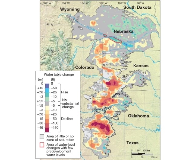
-According to the map, most of the lowering of the water table level in the Ogallala Aquifer has occurred in the __________ portion(s) of the aquifer.
A) northwestern
B) northeastern
C) northeastern and central
D) central and southern
Correct Answer:

Verified
Correct Answer:
Verified
Q132: Soil is the layer of sediment that
Q133: <img src="https://d2lvgg3v3hfg70.cloudfront.net/TB8400/.jpg" alt=" -This photo shows
Q134: Why are some farm fields circular?<br>A)because circles
Q135: Water enters an aquifer through groundwater discharge.
Q136: <img src="https://d2lvgg3v3hfg70.cloudfront.net/TB8400/.jpg" alt=" -Using Table 11.1,
Q138: The average topsoil depth worldwide ranges from
Q139: <img src="https://d2lvgg3v3hfg70.cloudfront.net/TB8400/.jpg" alt=" -Transported clays and
Q140: Healthy topsoil does not have bacteria living
Q141: <img src="https://d2lvgg3v3hfg70.cloudfront.net/TB8400/.jpg" alt=" -According to the
Q142: <img src="https://d2lvgg3v3hfg70.cloudfront.net/TB8400/.jpg" alt=" -Referring to Figure