Multiple Choice
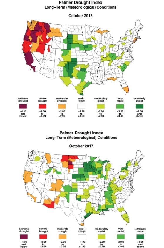
-On the October 2017 map, which region shows the greatest moisture deficits?
A) the northern Great Plains, including Montana and the Dakotas
B) the western states of California, Oregon, and Washington
C) the southern states of Florida, Georgia, and the Carolinas
D) the northeastern states, including Maine, New Hampshire, and Vermont
Correct Answer:

Verified
Correct Answer:
Verified
Q13: Water in the Ogallala Aquifer originated mostly
Q14: Through the process of _ rainwater carries
Q15: Clay has greater permeability than sand.
Q16: Fossil groundwater is water in an aquifer
Q17: <img src="https://d2lvgg3v3hfg70.cloudfront.net/TB8400/.jpg" alt=" -Reading this chart,
Q19: <img src="https://d2lvgg3v3hfg70.cloudfront.net/TB8400/.jpg" alt=" -According to the
Q20: Soil erosion can change soil texture.
Q21: <img src="https://d2lvgg3v3hfg70.cloudfront.net/TB8400/.jpg" alt=" -Which marked letter
Q22: <img src="https://d2lvgg3v3hfg70.cloudfront.net/TB8400/.jpg" alt=" -In the figure,
Q23: <img src="https://d2lvgg3v3hfg70.cloudfront.net/TB8400/.jpg" alt=" -The _ is