Multiple Choice
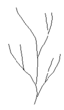
-What type of drainage pattern is depicted in the map?
A) dendritic
B) radial
C) rectangular
D) trellis
Correct Answer:

Verified
Correct Answer:
Verified
Related Questions
Q5: The rocky cliffs that characterize the Oregon
Q6: The steeper, downwind side of a sand
Q7: Use the schematic topographic profile of the
Q8: In which of the following flow patterns
Q9: Most recorded shipwrecks occur within sight of
Q11: Which of the following terms describes the
Q12: The slope of the upwind side of
Q13: Geologic processes powered by wind are called
Q14: <img src="https://d2lvgg3v3hfg70.cloudfront.net/TBMC1067/.jpg" alt=" -The area labeled
Q15: The muddy or sandy areas that are