Multiple Choice
Which of the three labeled locations on the topographic map above has the highest risk of mass wasting?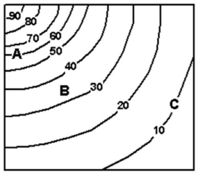 (Numbers represent elevation in meters above sea level.)
A) A
B) B
C) C
D) All three locations are equal.
Correct Answer:

Verified
Correct Answer:
Verified
Q4: Mudflows and debris flows occur when water
Q5: <img src="https://d2lvgg3v3hfg70.cloudfront.net/TB10899/.jpg" alt=" -Complete the concept
Q6: Read the following USGS statement and answer
Q7: The term "landslide"<br>applies to several forms of
Q8: <img src="https://d2lvgg3v3hfg70.cloudfront.net/TB10899/.jpg" alt=" -What common rockfall
Q10: Slumps occur when soils slowly move down
Q11: Creep is the rapid movement of material
Q12: How and why does saturation change the
Q13: Rockfalls happen when boulders on rocky cliffs
Q14: Read the following USGS statement and answer