Exam 18: Deserts and Winds
Exam 1: An Introduction to Geology and Plate Tectonics198 Questions
Exam 2: Minerals: The Building Blocks of Rocks185 Questions
Exam 3: Igneous Rocks190 Questions
Exam 4: Volcanoes and Volcanic Processes155 Questions
Exam 5: Weathering and Soil157 Questions
Exam 6: Sedimentary Rocks234 Questions
Exam 7: Metamorphism and Metamorphic Rocks143 Questions
Exam 8: Geologic Time143 Questions
Exam 9: Crustal Deformation145 Questions
Exam 10: Earthquakes and Earth's Interior185 Questions
Exam 11: The Ocean Floor172 Questions
Exam 12: Plate Tectonics: The Framework for Modern Geology162 Questions
Exam 13: Mountain Building and Continental Frameworks161 Questions
Exam 14: Mass Wasting: The Work of Gravity131 Questions
Exam 15: Running Water139 Questions
Exam 16: Groundwater159 Questions
Exam 17: Glaciers and Glaciation183 Questions
Exam 18: Deserts and Winds132 Questions
Exam 19: Shorelines153 Questions
Exam 20: Mineral and Energy Resources159 Questions
Select questions type
Refer to the world drylands map (fig.18.2)and the atmospheric circulation diagram (fig.18.3A)to answer the question(s)below.
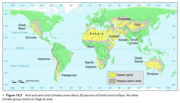
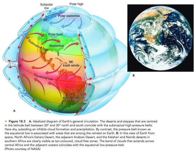 -Which desert is a low-latitude, subtropical desert characterized by high atmospheric pressures and descending air masses (not rain shadow deserts).
(Short Answer)
4.8/5  (39)
(39)
What is the normal range of annual precipitation in Canada's Arctic polar deserts?
(Short Answer)
4.8/5 (33)
Stream channels in dry lands that only carry water in response to infrequent rainfall or snowmelt events are called ________.
(Multiple Choice)
4.8/5 (31)
________ is the skipping and bouncing transport of sand in blowing wind and running water.
(Short Answer)
4.8/5 (44)
During a typical sandstorm, saltating sand grains reach a maximum height of about ________ above the land surface.
(Multiple Choice)
4.9/5 (36)
Which one of the following is the best measure of the wetness or dryness of a region?
(Multiple Choice)
4.9/5 (36)
________ dunes are linear sand ridges at right angles to the prevailing wind direction in coastal areas, with a steady supply of sand.
(Multiple Choice)
4.7/5 (40)
In North America, loess deposits are found mainly in the dry to semiarid lands of southwestern United States and northern Mexico.
(True/False)
4.9/5 (40)
What is the term for a streamlined, wind-sculpted rock ridge oriented parallel to prevailing wind direction?
(Short Answer)
4.9/5 (27)
Desert and steppe lands cover about what percentage of Earth's land area?
(Multiple Choice)
4.8/5 (40)
________ dunes have their tips facing upwind because they are commonly anchored by vegetation.
(Short Answer)
4.9/5 (44)
Intermittent streams in dry areas of the western United States are called ephemeral.
(True/False)
4.9/5 (37)
What is the term for a small depression formed by deflation of a desert floor?
(Short Answer)
4.7/5 (33)
The tips of ________ dunes point upwind and commonly result from persistent, onshore winds in certain coastal areas.
(Multiple Choice)
4.7/5 (38)
What is the angle of repose for coarse dry sand, as on the slip face of a dune, and is this steep enough that you could use a snowboard there for a swift descent?
(Essay)
4.8/5 (28)
Filters
- Essay(0)
- Multiple Choice(0)
- Short Answer(0)
- True False(0)
- Matching(0)