Exam 10: Crustal Deformation and Mountain Building
Exam 1: Introduction to Earth Science106 Questions
Exam 2: Matter and Minerals114 Questions
Exam 3: Rocks: Materials of the Solid Earth120 Questions
Exam 4: Weathering, soil, and Mass Wasting125 Questions
Exam 5: Running Water and Groundwater133 Questions
Exam 6: Glaciers, deserts, and Wind90 Questions
Exam 7: Plate Tectonics: a Scientific Revolution Unfolds88 Questions
Exam 8: Earthquakes and Earths Interior85 Questions
Exam 9: Volcanoes and Other Igneous Activity100 Questions
Exam 10: Crustal Deformation and Mountain Building97 Questions
Exam 11: Geologic Time105 Questions
Exam 12: Earths Evolution Through Geologic Time134 Questions
Exam 13: The Ocean Floor92 Questions
Exam 14: Ocean Water and Ocean Life75 Questions
Exam 15: The Dynamic Ocean119 Questions
Exam 16: The Atmosphere: Composition,structure,and Temperature82 Questions
Exam 17: Moisture, clouds, and Precipitation113 Questions
Exam 18: Air Pressure and Wind98 Questions
Exam 19: Weather Patterns and Severe Weather95 Questions
Exam 20: World Climates and Global Climate Change107 Questions
Exam 21: Origin of Modern Astronomy111 Questions
Exam 22: Touring Our Solar System93 Questions
Exam 23: Light,astronomical Observations,and the Sun96 Questions
Exam 24: Beyond Our Solar System85 Questions
Select questions type
You are walking on the beach along the south-coast of Alaska.You see rocks cut by numerous faults that consist of basalt with evidence of eruption in the ocean,deep-water chert,mudstone,and sandstones with abundant volcanic material.What tectonic setting would you assign to these rocks?
Free
(Multiple Choice)
4.9/5  (29)
(29)
Correct Answer: Verified
D
Granitic batholiths typically form over time intervals of ________.
Free
(Multiple Choice)
4.9/5 (31)
Correct Answer:Verified
D
In a(n)________ fault,the hanging wall block moves up with respect to the footwall block.
Free
(Multiple Choice)
4.8/5 (32)
Correct Answer:Verified
C
Mountain building uplifts rocks against the force of gravity raising their potential energy,which requires work by the earth system.Based on the relative motion of fault blocks,what type of fault would you expect to require more energy than the others?
(Multiple Choice)
4.9/5 (29)
Subduction only occurs when oceanic rocks are forced beneath a continent.
(True/False)
4.8/5 (43)
Monoclines,anticlines,synclines and domes are all examples of ________.
(Multiple Choice)
4.9/5 (30)
Ocean spreading centers are highlands on the ocean floor,sometimes referred to as submarine mountains.Oceanic crust worldwide is about the same thickness so isostasy would suggest the ocean floor should be as flat as Kansas.Which of the following statements best describes the origin of these submarine mountains?
(Multiple Choice)
4.7/5 (41)
Studies of the chemistry of rocks from arc volcanos indicate the main source of the magma is ________.
(Multiple Choice)
4.9/5 (33)
Use this figure for the following questions:  The figure above is an oblique Google earth image from southwestern North America looking approximately north.The view is approximately 50km across.The area is a classic area of normal faulting.
-The area labeled C shows an active fault bounding the range.Which best describes the motion on the fault?
The figure above is an oblique Google earth image from southwestern North America looking approximately north.The view is approximately 50km across.The area is a classic area of normal faulting.
-The area labeled C shows an active fault bounding the range.Which best describes the motion on the fault?
(Multiple Choice)
4.7/5 (32)
Evaluate the following statement,addressing what parts,if any,are right and which are wrong:
Jointing in rocks does not affect the flow of groundwater at depths greater than 10-20m because all fractures close below that depth.Jointing is important,however,to engineers interested in stability of slopes and locating structures because joints can slide or open under gravitational forces on slopes.
(Essay)
4.7/5 (39)
In the interior of continents the earth's crust is typically about 40km thick and the elevation is near sea level.In an area where the crust is 20km thick,isostasy would suggest the elevation in this area would be ________ unless the density changes from one area to the other.
(Multiple Choice)
4.8/5 (32)
Southwestern North America contains a large area called the Basin and Range province.What is the origin of this name?
(Multiple Choice)
4.8/5 (36)
Use this figure for the following questions: 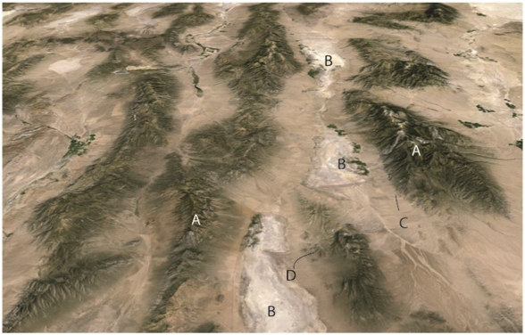 The figure above is an oblique Google earth image from southwestern North America looking approximately north.The view is approximately 50km across.The area is a classic area of normal faulting.
-Topographic basins like the areas labeled B in this figure are called ________.
The figure above is an oblique Google earth image from southwestern North America looking approximately north.The view is approximately 50km across.The area is a classic area of normal faulting.
-Topographic basins like the areas labeled B in this figure are called ________.
(Short Answer)
4.9/5 (34)
In the figure,which of the deformations appears most similar to what might be expected along a divergent plate boundary?
(Multiple Choice)
4.8/5 (28)
Burial of rocks increases the confining pressure so that deeply buried rocks are more likely to ________ than shallow rocks.
(Multiple Choice)
4.9/5 (34)
Oceanic plateaus and seamounts are both bathymetric highs on the seafloor.When they encounter a subduction zone oceanic plateaus are generally accreted to become a(n)________ whereas seamounts typically are ________.
(Short Answer)
4.8/5 (33)
Mountain building in the western margin of North America records a history of both ________.
(Multiple Choice)
4.8/5 (29)
Changes in the shape of a rock body in response to a differential stress is called ________.
(Short Answer)
4.9/5 (28)
Filters
- Essay(0)
- Multiple Choice(0)
- Short Answer(0)
- True False(0)
- Matching(0)