Exam 10: Crustal Deformation and Mountain Building
Exam 1: Introduction to Earth Science106 Questions
Exam 2: Matter and Minerals114 Questions
Exam 3: Rocks: Materials of the Solid Earth120 Questions
Exam 4: Weathering, soil, and Mass Wasting125 Questions
Exam 5: Running Water and Groundwater133 Questions
Exam 6: Glaciers, deserts, and Wind90 Questions
Exam 7: Plate Tectonics: a Scientific Revolution Unfolds88 Questions
Exam 8: Earthquakes and Earths Interior85 Questions
Exam 9: Volcanoes and Other Igneous Activity100 Questions
Exam 10: Crustal Deformation and Mountain Building97 Questions
Exam 11: Geologic Time105 Questions
Exam 12: Earths Evolution Through Geologic Time134 Questions
Exam 13: The Ocean Floor92 Questions
Exam 14: Ocean Water and Ocean Life75 Questions
Exam 15: The Dynamic Ocean119 Questions
Exam 16: The Atmosphere: Composition,structure,and Temperature82 Questions
Exam 17: Moisture, clouds, and Precipitation113 Questions
Exam 18: Air Pressure and Wind98 Questions
Exam 19: Weather Patterns and Severe Weather95 Questions
Exam 20: World Climates and Global Climate Change107 Questions
Exam 21: Origin of Modern Astronomy111 Questions
Exam 22: Touring Our Solar System93 Questions
Exam 23: Light,astronomical Observations,and the Sun96 Questions
Exam 24: Beyond Our Solar System85 Questions
Select questions type
Refer to the figure below,captured from Google Earth,for the following questions. 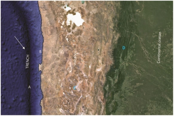 -Location A would be an area where you would expect ________ faulting
(Short Answer)
4.7/5  (35)
(35)
Use this figure for the following questions: 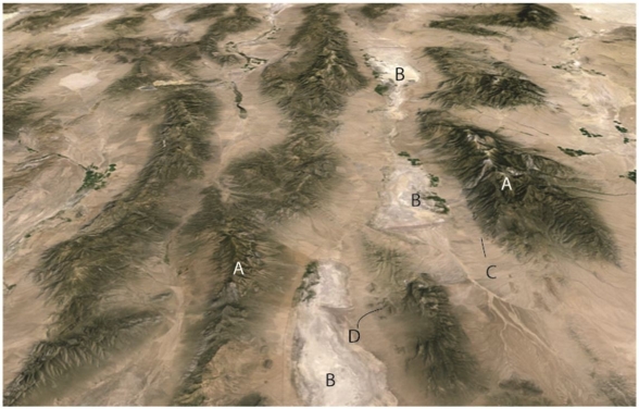 The figure above is an oblique Google earth image from southwestern North America looking approximately north.The view is approximately 50km across.The area is a classic area of normal faulting.
-This area represents what type of mountain system
The figure above is an oblique Google earth image from southwestern North America looking approximately north.The view is approximately 50km across.The area is a classic area of normal faulting.
-This area represents what type of mountain system
(Multiple Choice)
4.7/5 (38)
In what part of a subduction margin might you find rocks deposited on the abyssal plain,far from land?
(Multiple Choice)
4.9/5 (36)
Use this figure for the following questions: 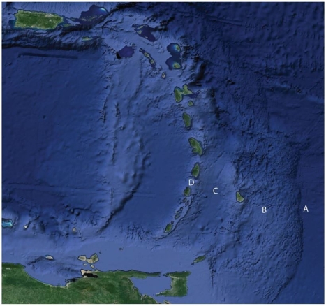 The figure above shows a popular area for North American tourists in winter,the Caribbean region.Match the term to the letter on the Figure.
-Trench
The figure above shows a popular area for North American tourists in winter,the Caribbean region.Match the term to the letter on the Figure.
-Trench
(Short Answer)
4.8/5 (44)
Recall that the Hawaiian Islands are a large volcanic chain on the Pacific produced by the Pacific plate moving over a hot spot.When the Hawaiian islands reach a trench and they are accreted to a continental margin they would produce a(n)________ comprised primarily of the rock type called ________.
(Short Answer)
4.8/5 (42)
The material in the figure was ________ when the folding occurred.
(Multiple Choice)
4.7/5 (39)
The concepts of "stress" and "strain" are related because ________.
(Multiple Choice)
4.9/5 (36)
A thrust fault increases the thickness of the crust as it moves toward a continental interior in a mountain belt; yet the crust beyond the mountain front stays the same thickness.Isostasy would suggest that the area at the mountain front,where the thrust emerges,should ________ over time.
(Multiple Choice)
4.7/5 (33)
The hinge of a fold must lie within the axial plane of the fold.
(True/False)
4.7/5 (39)
Use this figure for the following questions: The figure above shows a popular area for North American tourists in winter,the Caribbean region.Match the term to the letter on the Figure.
-Accretionary Wedge
(Short Answer)
4.8/5 (36)
Briefly describe how time,temperature,mineralogy,and confining pressure affect the way a rock will deform when the differential stresses on the rock exceed the strength of the rock.
(Essay)
4.9/5 (32)
You are walking north across dipping beds in sedimentary rocks.You walk across 200m of rocks with a relatively constant dip of 20 degrees to the south.Suddenly you come to beds with lower dip that become flat lying,and then dip north across a horizontal distance of only about 30m.As you walk on the beds become more steeply dipping until they dip almost 80 degrees to the north.You walk across these steeply dipping beds for 40m,and then beds return to a south dip of about 20 degrees.What kind of structure(s)did you just walk across? (A sketch may help you solve this problem.)
(Multiple Choice)
4.7/5 (31)
The San Andreas Fault in California and the Alpine Fault in New Zealand are examples of ________.
(Multiple Choice)
4.9/5 (31)
A widely cited theory associates active faults and earthquakes in China and southeast Asia to the India-Eurasia collision.This theory suggests ________.
(Multiple Choice)
4.8/5 (35)
In the interior of continents the earth's crust is typically about 40 km thick and the elevation is near sea level.In the Himalayas the crust is more than 60km thick.Isostasy says crust thicker than this average should produce elevated terrain (mountains),so why isn't the elevation of the Himalayas 20km?
(Essay)
4.8/5 (42)
Any accreted crustal fragment that has a geologic history distinct from that of the adjoining fragments is termed a(n)________.
(Short Answer)
4.8/5 (35)
On the blanks provided below,fill in the name of the specific type of geologic features that have been labeled. 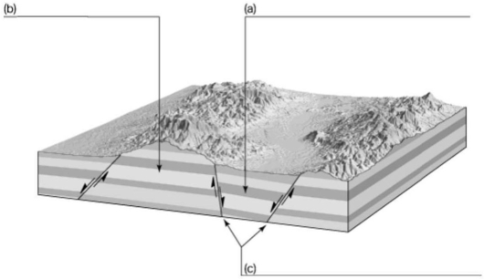
(Short Answer)
4.9/5 (44)
Filters
- Essay(0)
- Multiple Choice(0)
- Short Answer(0)
- True False(0)
- Matching(0)