Multiple Choice
In the following model, what is the missing GIS operation? 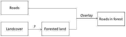
A) reclassify
B) buffer
C) polygon-on-polygon overlay
D) none of the above
Correct Answer:

Verified
Correct Answer:
Verified
Related Questions
Q7: Spatial interpolation is a method for creating
Q8: Below are cross sections of a terrain
Q9: Low-order trend surfaces are not good for
Q10: Cost distance can be weighted by<br>A) cost
Q11: Kriging uses the following equation to
Q13: In order to minimise edge effects in
Q14: <span class="ql-formula" data-value="\begin{array}{l}\begin{array}{|l|l|l|}\hline 1 & 1 &
Q15: With which of the following weight values
Q16: Map algebra is used to build mathematical
Q17: We have two rasters:<br><img src="https://d2lvgg3v3hfg70.cloudfront.net/TBR1264/.jpg" alt="We have