Multiple Choice
Below are cross sections of a terrain surface. The dots represent sampled points, the dotted line represents the cross section of the real terrain surface, and the solid lines represent cross sections of the interpolated surfaces. Which solid line more likely represents the cross section of the surface interpolated using IDW?
A) 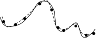
B) 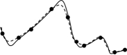
C) 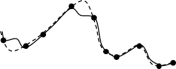
Correct Answer:

Verified
Correct Answer:
Verified
Q3: In kriging, semivariance is a function of<br>A)
Q4: Addition of two rasters: <span
Q5: <img src="https://d2lvgg3v3hfg70.cloudfront.net/TBR1264/.jpg" alt=" The above operation
Q6: Kriging assumes that the variation in a
Q7: Spatial interpolation is a method for creating
Q9: Low-order trend surfaces are not good for
Q10: Cost distance can be weighted by<br>A) cost
Q11: Kriging uses the following equation to
Q12: In the following model, what is the
Q13: In order to minimise edge effects in