Multiple Choice
2) In classifying the climate of this imaginary country, the wettest and coolest areas are in the ______. The colors represent temperatures (warmest is red, coolest is purple) , and the contour lines represent average precipitation in millimeters.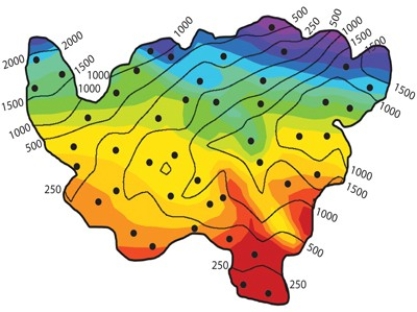
A) southwest.
B) northeast.
C) southeast.
D) northwest.
Correct Answer:

Verified
Correct Answer:
Verified
Q1: 18)Though Khartoum and Urumqi both have dry
Q2: 136)The Ogallala Aquifer is located:<br>A)along the Ogallala
Q3: 80)The clay-rich soil pictured below is a<br><img
Q4: 106)In the shorelines investigation, what shoreline feature
Q5: 73)Which of these graphs represents a site
Q6: 17)The feature in this photograph is a(n):<br><img
Q7: 72)Which of the following sites in South
Q8: 71)Which of the following sites in South
Q9: 247)Entrenched meanders represent:<br>A)stream segments that have been