Multiple Choice
Read the following exert from a USGS report concerning a recent earthquake and answer this question.
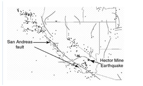
Special Report: The Hector Mine Earthquake, 10/16/1999
A M7.1 earthquake occurred at 2:46 a.m. local time on 10/16/1999.
The event was located in a remote, sparsely-populated part of the Mojave Desert of California,
approximately 47 miles east-southeast of Barstow and 32 miles north of Joshua Tree (see map next page) .
The initial magnitude estimate of 7.0 was upgraded to 7.1 on October 18, 1999, based on in-depth analysis
of "teleseismic" data recorded worldwide.
The earthquake occurred on the Lavic Lake fault, one of a series of north-northwest trending faults
through the eastern Mojave shear zone. Geologists from the U.S. Geological Survey and Southern
California Earthquake Center were able to fly over the rupture (which is within the Twenty Nine Palms
Marine Base) on the afternoon of October 16 and documented a 40-km long surface rupture. The aerial
photos show an apparent maximum offset of 3.8-4.7 meters. These preliminary estimates for both fault
length and slip are consistent with expectations for a magnitude 7.0 earthquake, although the slip is
perhaps somewhat larger than average. The fault is one of a series of closely spaced, northwest-trending,
right-lateral strike slip faults that traverse this portion of the Mojave Desert. Together, these faults within
what is termed the Mojave Shear Zone serve to relieve a small portion of the stresses that build up along
the boundary between the Pacific and North American tectonic plates.
An interesting aspect of the Hector Mine earthquake is that it occurred only 7 years after the 1992 Landers
and Joshua Tree earthquakes, which occurred on similar faults within the Mojave Shear Zone. This
apparent clustering of earthquakes may be purely coincidental, but scientists are conducting research to
see if this kind of earthquake behavior is typical of this region. That is, perhaps many of the Mojave Shear
Zone faults produce earthquakes within a short time interval (perhaps spanning several hundred or more
years) , followed by several thousands of years of quiescence.
-What evidence was used to identify the exact location of the fault responsible for the earthquake?
A) Teleseismic data
B) Reported by local population
C) Surface rupture
D) Previous history of earthquakes
Correct Answer:

Verified
Correct Answer:
Verified
Q5: Complete the concept map by selecting the
Q6: Use the following map related to the
Q7: Complete the concept map by selecting the
Q8: You learned in class and in the
Q9: Analyze the table below that shows USGS
Q11: Complete the concept map by selecting the
Q12: <img src="https://d2lvgg3v3hfg70.cloudfront.net/TB10899/.jpg" alt=" -Consider the 26
Q13: Use the following map related to the
Q14: <img src="https://d2lvgg3v3hfg70.cloudfront.net/TB10899/.jpg" alt=" -Suppose you read
Q15: Read the following exert from a USGS