Multiple Choice
Use the following map related to the December 24th, 2004 Sumatra earthquake to answer this question.
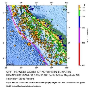
-How would you characterize the depth of the Sumatra earthquake?
A) Shallow depth
B) Moderate depth
C) Deep
Correct Answer:

Verified
Correct Answer:
Verified
Q8: You learned in class and in the
Q9: Analyze the table below that shows USGS
Q10: Read the following exert from a USGS
Q11: Complete the concept map by selecting the
Q12: <img src="https://d2lvgg3v3hfg70.cloudfront.net/TB10899/.jpg" alt=" -Consider the 26
Q14: <img src="https://d2lvgg3v3hfg70.cloudfront.net/TB10899/.jpg" alt=" -Suppose you read
Q15: Read the following exert from a USGS
Q16: <img src="https://d2lvgg3v3hfg70.cloudfront.net/TB10899/.jpg" alt=" -This earthquake-generated hazard
Q17: The earthquake magnitude system has a maximum
Q18: Complete the concept map by selecting the