Exam 11: Soil and Water Resources
Exam 1: This Introduction Covers the Traditional and Modern Tools and Foundational Concepts in Wide Use in Geography134 Questions
Exam 2: Portrait of the Atmosphere133 Questions
Exam 3: Solar Energy and Seasons135 Questions
Exam 4: Water in the Atmosphere146 Questions
Exam 5: Atmospheric Circulation and Wind Systems145 Questions
Exam 6: The Restless Sky: Severe Weather and Storm Systems137 Questions
Exam 7: The Changing Climate147 Questions
Exam 8: Patterns of Life: Biogeography150 Questions
Exam 9: Climate and Life: Biomes135 Questions
Exam 10: Ocean Ecosystems135 Questions
Exam 11: Soil and Water Resources142 Questions
Exam 12: Earth History, Earth Interior124 Questions
Exam 13: Drifting Continents: Plate Tectonics142 Questions
Exam 14: Building the Crust With Rocks139 Questions
Exam 15: Geohazards: Volcanoes and Earthquakes148 Questions
Exam 16: Weathering and Mass Movement140 Questions
Exam 17: Flowing Water: Fluvial Systems136 Questions
Exam 18: The Work of Ice: the Cryosphere and Glacial Landforms143 Questions
Exam 19: Water, Wind, and Time: Desert Landforms135 Questions
Exam 20: The Work of Waves: Coastal Landforms138 Questions
Select questions type
 -The ease with which water can flow through the ground depends mostly on the __________ of the ground.
(Multiple Choice)
4.8/5  (43)
(43)
__________ is a lowering of the water table level around a well that results from withdrawing water from an aquifer faster than it is recharged.
(Multiple Choice)
4.8/5 (38)
__________ is the practice of creating furrows in the soil that run parallel to a line of equal elevation.
(Multiple Choice)
4.9/5 (32)
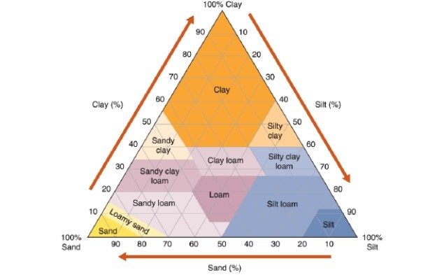 -Reading this chart, what percentage of "silty clay" is composed of silt?
(Multiple Choice)
4.8/5 (34)
Groundwater mining occurs where water is taken from an aquifer that has rapid natural recharge.
(True/False)
4.8/5 (38)
Soil erosion by wind removes particles of silt and clay before it removes sand.
(True/False)
4.8/5 (39)
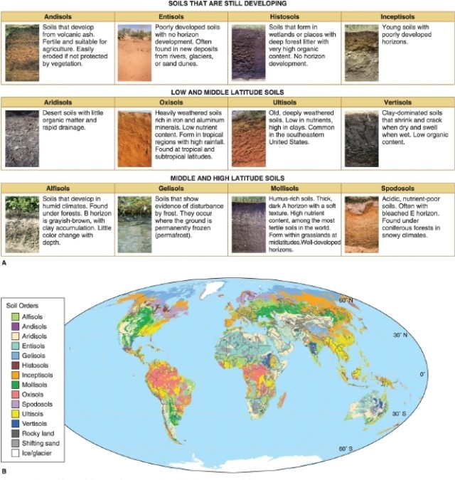
 -According to the figure, soils found in new deposits from rivers, glaciers, and sand dunes are called __________.
(Multiple Choice)
4.9/5 (38)
__________ is the practice of creating shelves of standing water on very steep slopes to grow crops, notably rice.
(Multiple Choice)
4.9/5 (36)
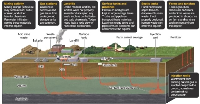 -Referring to the figure, which does not contaminate groundwater?
(Multiple Choice)
4.8/5 (36)
Soil is the layer of sediment that has been modified by organisms and water, and is the region where plant roots extend.
(True/False)
4.9/5 (41)
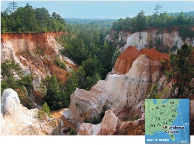 -This photo shows Georgia's Providence Canyon.What human activity resulted in this canyon?
(Multiple Choice)
4.7/5 (36)
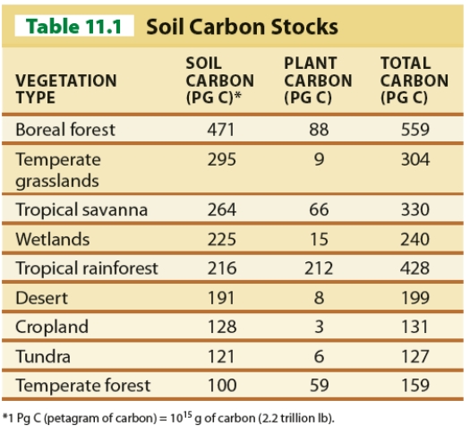 -Using Table 11.1, which vegetation type has the highest soil-carbon content?
(Multiple Choice)
4.8/5 (33)
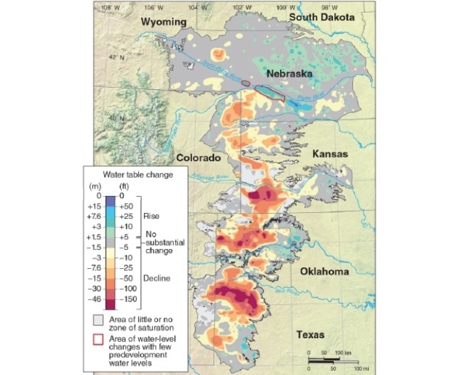 -According to the map, most of the lowering of the water table level in the Ogallala Aquifer has occurred in the __________ portion(s) of the aquifer.
(Multiple Choice)
5.0/5 (39)
The average topsoil depth worldwide ranges from __________ centimeters.
(Multiple Choice)
4.8/5 (40)
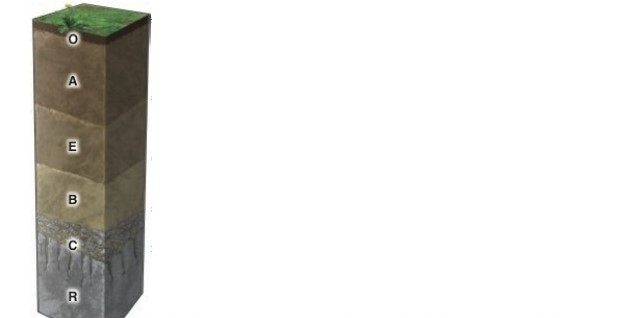 -Transported clays and dissolved chemicals are deposited through the process of illuviation in the __________ horizon.
(Multiple Choice)
4.9/5 (35)
Filters
- Essay(0)
- Multiple Choice(0)
- Short Answer(0)
- True False(0)
- Matching(0)