Exam 7: Terrain Analysis
Exam 1: GIS Overview10 Questions
Exam 2: Spatial Data and Data Management28 Questions
Exam 3: Spatial Data Input and Manipulation22 Questions
Exam 4: Spatial Analysis28 Questions
Exam 5: Spatial Data Exploration With Statistics16 Questions
Exam 6: Remote Sensing Data Analysis34 Questions
Exam 7: Terrain Analysis16 Questions
Exam 8: Spatial Visualisation16 Questions
Exam 9: Spatial Modeling and Decision Analysis11 Questions
Exam 10: Environmental Applications of GIS16 Questions
Select questions type
As the spatial resolution of a DEM decreases, the number of sinks
Free
(Multiple Choice)
4.9/5  (29)
(29)
Correct Answer: Verified
A
To answer the question 'how can an aesthetically unpleasant building be optimally hidden in the terrain in order to preserve the beauty of a landscape?', it is better to use
Free
(Multiple Choice)
4.8/5 (50)
Correct Answer:Verified
A
Flow accumulation is calculated based on
Free
(Multiple Choice)
4.8/5 (30)
Correct Answer:Verified
C
Slope is measured either in degrees or percentage. 45 degree is equivalent to
(Multiple Choice)
4.9/5 (41)
Below is a DEM. Which landform is at Locations labelled as 1? g 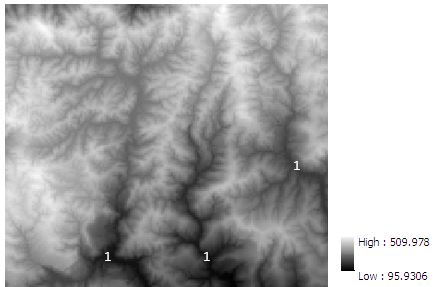
(Multiple Choice)
4.9/5 (39)
The flow length tool in GIS with UPSTREAM option calculates
(Multiple Choice)
4.8/5 (34)
In the following flow accumulation map derived from the above DEM, ridge lines can be formed by linking locations with a flow accumulation value of 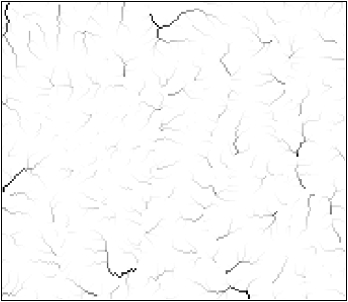

(Multiple Choice)
4.8/5 (42)
In order to answer the question 'can a tower in the terrain be seen from a given viewpoint?', which of the following GIS operations is the best?
(Multiple Choice)
4.7/5 (35)
If a plateau is eroded by gullies, the remaining plateau would be a flat (planar) area bounded by an irregular, many-sided polygon. In the TIN model
(Multiple Choice)
4.9/5 (34)
On a flow accumulation raster layer, locations having an accumulation value of 0 correspond to
(Multiple Choice)
4.8/5 (36)
Filters
- Essay(0)
- Multiple Choice(0)
- Short Answer(0)
- True False(0)
- Matching(0)