Exam 4: Spatial Analysis
Exam 1: GIS Overview10 Questions
Exam 2: Spatial Data and Data Management28 Questions
Exam 3: Spatial Data Input and Manipulation22 Questions
Exam 4: Spatial Analysis28 Questions
Exam 5: Spatial Data Exploration With Statistics16 Questions
Exam 6: Remote Sensing Data Analysis34 Questions
Exam 7: Terrain Analysis16 Questions
Exam 8: Spatial Visualisation16 Questions
Exam 9: Spatial Modeling and Decision Analysis11 Questions
Exam 10: Environmental Applications of GIS16 Questions
Select questions type
A smaller power value in IDW results in a smoother surface
Free
(True/False)
4.9/5  (38)
(38)
Correct Answer: Verified
True
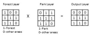 In the output layer, 1 represents
Free
(Multiple Choice)
4.7/5 (48)
Correct Answer:Verified
C
In kriging, semivariance is a function of
Free
(Multiple Choice)
4.9/5 (35)
Correct Answer:Verified
B
Addition of two rasters: 2 4 3 4 1 2 5 6 4 + 2 4 3 2 1 6 7 5 8 =
(Multiple Choice)
4.9/5 (40)
Kriging assumes that the variation in a surface consists of three components, which are
(Multiple Choice)
4.8/5 (38)
Spatial interpolation is a method for creating surfaces to approximate spatial distributions of environmental phenomena based on point observations
(True/False)
4.8/5 (44)
Below are cross sections of a terrain surface. The dots represent sampled points, the dotted line represents the cross section of the real terrain surface, and the solid lines represent cross sections of the interpolated surfaces. Which solid line more likely represents the cross section of the surface interpolated using IDW?
(Multiple Choice)
4.8/5 (28)
Kriging uses the following equation to calculate interpolated values.
The weight wi depends on
(Multiple Choice)
4.9/5 (40)
In order to minimise edge effects in spatial interpolation, you should
(Multiple Choice)
4.8/5 (31)
With which of the following weight values (τ), does a regularised spline produce a smoother surface?
(Multiple Choice)
4.8/5 (31)
We have two rasters:
 Which mathematical operator can be used to overlay them in order to produce meaningful results?
(Multiple Choice)
4.8/5 (34)
A distance surface map (e.g., the proximity to a nuclear waste disposal facility) can be used to produce a buffer map (e.g., a 1km buffer around the disposal facility) by applying
(Multiple Choice)
4.9/5 (36)
Raster overlay is more commonly used than vector overlay for environmental modelling, because
(Multiple Choice)
4.9/5 (31)
IDW, second-order trend surface, regularised spline and spline with tension were used to interpolate surfaces based on the same set of sample points. The RMSE errors generated by IDW, second-order trend surface, regularised spline and spline with tension are respectively 0.87, 1.72, 1.01 and 0.99. Which interpolation method produced the best results?
(Multiple Choice)
4.9/5 (42)
Filters
- Essay(0)
- Multiple Choice(0)
- Short Answer(0)
- True False(0)
- Matching(0)