Exam 5: Weather Systems and Severe Weather
Exam 1: The Nature of Physical Geography84 Questions
Exam 2: Energy and Matter in the Atmosphere81 Questions
Exam 3: Atmospheric Motion81 Questions
Exam 4: Atmospheric Moisture85 Questions
Exam 5: Weather Systems and Severe Weather83 Questions
Exam 6: Atmosphere-Ocean-Cryosphere Interactions93 Questions
Exam 7: Climates Around the World82 Questions
Exam 8: Water Resources83 Questions
Exam 9: Understanding Landscapes150 Questions
Exam 10: Plate Tectonics and Regional Features137 Questions
Exam 11: Volcanoes,deformation,and Earthquakes218 Questions
Exam 12: Weathering and Mass Wasting81 Questions
Exam 13: Streams and Flooding98 Questions
Exam 14: Glaciers and Glacial Landforms75 Questions
Exam 15: Coasts and Changing Sea Levels80 Questions
Exam 16: Soils90 Questions
Exam 17: Ecosystems and Biogeochemical Cycles90 Questions
Exam 18: Biomes85 Questions
Select questions type
Midlatitude anticyclones are likely to form at which part of a Rossby Wave? Where
(Multiple Choice)
4.9/5  (33)
(33)
This satellite image shows conditions on Day 1 of the weather investigation.What is likely to be the general path of the storm system in the center of the U.S.from this day to the next (Day 2)? 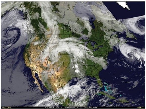
(Multiple Choice)
4.8/5 (37)
Which of the following locations would spawn a storm track known as a "Noreaster" that is difficult to forecast and can bring heavy snow? 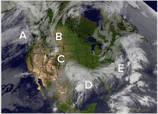
(Multiple Choice)
4.8/5 (42)
Which of the following was discussed in the opening two-page spread of the Weather Systems and Severe Weather chapter?
(Multiple Choice)
4.7/5 (36)
Which of the following locations would contribute to midlatitude cyclogenesis?
(Multiple Choice)
4.9/5 (46)
Find the largest cold front located on the map.The likely air mass to the west of the cold front is a ________ mass that is likely to be ________ than the air mass to the east. 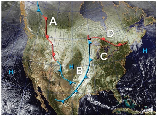
(Multiple Choice)
4.9/5 (37)
Which of the following represents the correct charge sequence to create lightning? 
(Multiple Choice)
4.7/5 (39)
All of the following is true regarding Doppler radar except
(Multiple Choice)
4.8/5 (40)
In the anticyclone pictured here,the winds at area A are from the ________ bringing ________ temperatures. 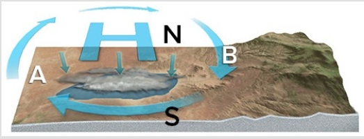
(Multiple Choice)
4.9/5 (34)
During the summer,which of the following regions would experience the greatest number of tornadoes?
(Multiple Choice)
4.8/5 (37)
Which stage in thunderstorm formation is characterized by updrafts accompanied by downdrafts induced by falling precipitation?
(Multiple Choice)
4.8/5 (46)
Which state,as a whole,experiences the highest frequency of thunderstorms in the United States?
(Multiple Choice)
4.7/5 (42)
In the anticyclone pictured here,the winds at area B are from the ________ bringing ________ temperatures. 
(Multiple Choice)
4.8/5 (34)
This satellite image shows conditions on Day 1 of the weather investigation.What type of feature is located over the center of North America? 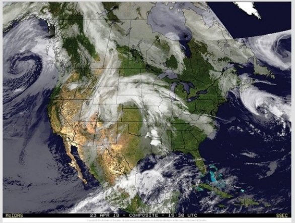
(Multiple Choice)
4.9/5 (34)
The most likely area for the development of tornadoes from this hurricane once it makes landfall is 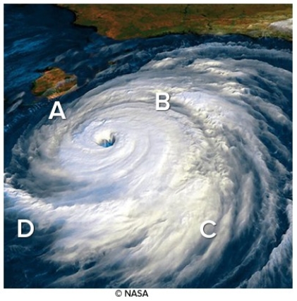
(Multiple Choice)
4.9/5 (42)
Which of the following regions received the most damage from Hurricane Sandy?
(Multiple Choice)
4.9/5 (36)
Which of the following best explains for the midlatitude cyclone tracking to the northeast and strengthening? 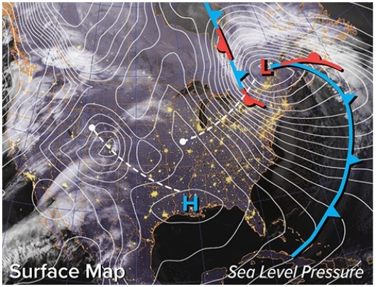
(Multiple Choice)
4.8/5 (43)
Filters
- Essay(0)
- Multiple Choice(0)
- Short Answer(0)
- True False(0)
- Matching(0)