Exam 5: Earthquakes
Exam 1: Introduction to Earth Science35 Questions
Exam 2: Earth in Science34 Questions
Exam 3: Near-Earth Objects29 Questions
Exam 4: Plate Tectonics64 Questions
Exam 5: Earthquakes47 Questions
Exam 6: Volcanoes and Mountains36 Questions
Exam 7: Rocks and Minerals47 Questions
Exam 8: Geologic Time58 Questions
Exam 9: Weathering and Soils36 Questions
Exam 10: Landslides and Slope Failure30 Questions
Exam 11: Streams and Floods48 Questions
Exam 12: Groundwater and Wetlands36 Questions
Exam 13: Oceans and Coastlines51 Questions
Exam 14: The Atomosphere46 Questions
Exam 15: Weather Systems40 Questions
Exam 16: Earths Climate System50 Questions
Exam 17: Global Change39 Questions
Select questions type
 -Suppose you were standing on a solid surface when S waves from a nearby earthquake arrived and you could feel them. What ground motion sensation would you feel?
Free
(Multiple Choice)
4.7/5  (25)
(25)
Correct Answer: Verified
B
P and S waves are both body waves.
Free
(True/False)
4.8/5 (31)
Correct Answer:Verified
True
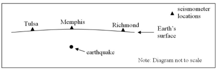
-Analyze the above schematic map for an earthquake. Which seismometers are needed to find the epicenter?
Free
(Multiple Choice)
4.8/5 (33)
Correct Answer:Verified
C
Magnitude is a measure of the size of an earthquake while intensity deals with the earthquake's effect on humans.
(True/False)
4.7/5 (36)
Complete the concept map by selecting the correct responses from the lists provided.
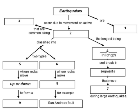 -Complete the concept map by selecting the correct responses from number 8.
(Multiple Choice)
4.8/5 (32)
Use the following map related to the December 24th, 2004 Sumatra earthquake to answer this question.
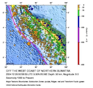 -What is the tectonic reason this earthquake occurred?
(Multiple Choice)
4.9/5 (28)
Complete the concept map by selecting the correct responses from the lists provided.
-What type of plate boundary is most likely to generate a tsunami?
(Multiple Choice)
4.8/5 (34)
You learned in class and in the reading that smaller magnitude earthquakes occur more frequently than larger magnitude earthquakes. So why do these actual data show fewer magnitude 2 and 3 earthquakes than magnitude 4 earthquakes?
(Multiple Choice)
4.8/5 (25)
Analyze the table below that shows USGS data for earthquake zones in Alaska and use it to answer this question.
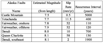 -What is the trend when comparing slip rate to estimated magnitude?
(Multiple Choice)
4.9/5 (35)
Read the following exert from a USGS report concerning a recent earthquake and answer this question.
Special Report: The Hector Mine Earthquake, 10/16/1999
A M7.1 earthquake occurred at 2:46 a.m. local time on 10/16/1999.
The event was located in a remote, sparsely-populated part of the Mojave Desert of California,
approximately 47 miles east-southeast of Barstow and 32 miles north of Joshua Tree (see map next page).
The initial magnitude estimate of 7.0 was upgraded to 7.1 on October 18, 1999, based on in-depth analysis
of "teleseismic" data recorded worldwide.
The earthquake occurred on the Lavic Lake fault, one of a series of north-northwest trending faults
through the eastern Mojave shear zone. Geologists from the U.S. Geological Survey and Southern
California Earthquake Center were able to fly over the rupture (which is within the Twenty Nine Palms
Marine Base) on the afternoon of October 16 and documented a 40-km long surface rupture. The aerial
photos show an apparent maximum offset of 3.8-4.7 meters. These preliminary estimates for both fault
length and slip are consistent with expectations for a magnitude 7.0 earthquake, although the slip is
perhaps somewhat larger than average. The fault is one of a series of closely spaced, northwest-trending,
right-lateral strike slip faults that traverse this portion of the Mojave Desert. Together, these faults within
what is termed the Mojave Shear Zone serve to relieve a small portion of the stresses that build up along
the boundary between the Pacific and North American tectonic plates.
An interesting aspect of the Hector Mine earthquake is that it occurred only 7 years after the 1992 Landers
and Joshua Tree earthquakes, which occurred on similar faults within the Mojave Shear Zone. This
apparent clustering of earthquakes may be purely coincidental, but scientists are conducting research to
see if this kind of earthquake behavior is typical of this region. That is, perhaps many of the Mojave Shear
Zone faults produce earthquakes within a short time interval (perhaps spanning several hundred or more
years), followed by several thousands of years of quiescence.
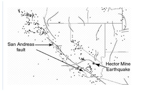 -What evidence was used to identify the exact location of the fault responsible for the earthquake?
(Multiple Choice)
4.9/5 (38)
Complete the concept map by selecting the correct responses from the lists provided.
-Complete the concept map by selecting the correct responses from number 1.
(Multiple Choice)
4.9/5 (45)
-Consider the 26 December, 2004 Indonesia earthquake where over 200,000 people died. If there had been an adequate tsunami warning system, how much time would there have been to get people to higher ground?
(Multiple Choice)
4.8/5 (42)
Use the following map related to the December 24th, 2004 Sumatra earthquake to answer this question.
-How would you characterize the depth of the Sumatra earthquake?
(Multiple Choice)
4.7/5 (40)
-Suppose you read this description of an earthquake from the 1880's. "The ground shook so hard that books fell off the desk." Which scale would be most appropriate for this type of information?
(Multiple Choice)
4.8/5 (32)
Read the following exert from a USGS report concerning a recent earthquake and answer this question.
Special Report: The Hector Mine Earthquake, 10/16/1999
A M7.1 earthquake occurred at 2:46 a.m. local time on 10/16/1999.
The event was located in a remote, sparsely-populated part of the Mojave Desert of California,
approximately 47 miles east-southeast of Barstow and 32 miles north of Joshua Tree (see map next page).
The initial magnitude estimate of 7.0 was upgraded to 7.1 on October 18, 1999, based on in-depth analysis
of "teleseismic" data recorded worldwide.
The earthquake occurred on the Lavic Lake fault, one of a series of north-northwest trending faults
through the eastern Mojave shear zone. Geologists from the U.S. Geological Survey and Southern
California Earthquake Center were able to fly over the rupture (which is within the Twenty Nine Palms
Marine Base) on the afternoon of October 16 and documented a 40-km long surface rupture. The aerial
photos show an apparent maximum offset of 3.8-4.7 meters. These preliminary estimates for both fault
length and slip are consistent with expectations for a magnitude 7.0 earthquake, although the slip is
perhaps somewhat larger than average. The fault is one of a series of closely spaced, northwest-trending,
right-lateral strike slip faults that traverse this portion of the Mojave Desert. Together, these faults within
what is termed the Mojave Shear Zone serve to relieve a small portion of the stresses that build up along
the boundary between the Pacific and North American tectonic plates.
An interesting aspect of the Hector Mine earthquake is that it occurred only 7 years after the 1992 Landers
and Joshua Tree earthquakes, which occurred on similar faults within the Mojave Shear Zone. This
apparent clustering of earthquakes may be purely coincidental, but scientists are conducting research to
see if this kind of earthquake behavior is typical of this region. That is, perhaps many of the Mojave Shear
Zone faults produce earthquakes within a short time interval (perhaps spanning several hundred or more
years), followed by several thousands of years of quiescence.
-There was considerable offset caused by this earthquake but little damage caused by this earthquake. Why?
(Multiple Choice)
4.8/5 (30)
-This earthquake-generated hazard can occur when seismic waves shake saturated soils.
(Multiple Choice)
4.8/5 (35)
Complete the concept map by selecting the correct responses from the lists provided.
-Complete the concept map by selecting the correct responses from number 6.
(Multiple Choice)
4.8/5 (37)
Complete the concept map by selecting the correct responses from the lists provided.
-Complete the concept map by selecting the correct responses from number 2.
(Multiple Choice)
4.7/5 (35)
Filters
- Essay(0)
- Multiple Choice(0)
- Short Answer(0)
- True False(0)
- Matching(0)