Exam 7: Climates Around the World
Exam 1: The Nature of Physical Geography84 Questions
Exam 2: Energy and Matter in the Atmosphere81 Questions
Exam 3: Atmospheric Motion81 Questions
Exam 4: Atmospheric Moisture85 Questions
Exam 5: Weather Systems and Severe Weather83 Questions
Exam 6: Atmosphere-Ocean-Cryosphere Interactions93 Questions
Exam 7: Climates Around the World82 Questions
Exam 8: Water Resources83 Questions
Exam 9: Understanding Landscapes150 Questions
Exam 10: Plate Tectonics and Regional Features137 Questions
Exam 11: Volcanoes,deformation,and Earthquakes218 Questions
Exam 12: Weathering and Mass Wasting81 Questions
Exam 13: Streams and Flooding98 Questions
Exam 14: Glaciers and Glacial Landforms75 Questions
Exam 15: Coasts and Changing Sea Levels80 Questions
Exam 16: Soils90 Questions
Exam 17: Ecosystems and Biogeochemical Cycles90 Questions
Exam 18: Biomes85 Questions
Select questions type
Migrating subtropical pressure zones generally produce dry summer conditions on the west side of continents because of
(Multiple Choice)
4.8/5  (43)
(43)
Cooler water and stable atmospheric conditions bring dry B climate conditions to the
(Multiple Choice)
4.9/5 (32)
Colors on this map of an imaginary country represent mean annual temperatures (reds above 28 degrees Celsius,blue and purple below 0 degrees Celsius). In classifying the climate of this imaginary country,the wettest and coolest areas are in the 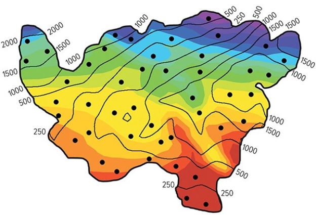
(Multiple Choice)
4.8/5 (36)
The Csa climate of Athens Greece owes its summer precipitation pattern to 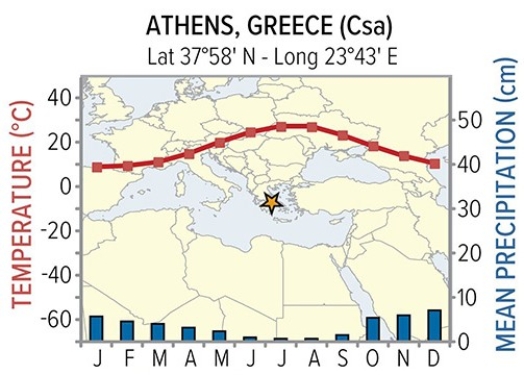
(Multiple Choice)
4.9/5 (45)
Which of the following sites on this figure contains a desert? 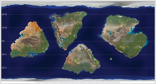
(Multiple Choice)
4.8/5 (45)
General Circulation Models (GCM)differ from Weather Forecasting Models (WFM)in all of the following ways except GCM
(Multiple Choice)
4.8/5 (34)
Temperatures become more variable and precipitation decreases as one travels from west to east from Europe into Asia.This is best explained by
(Multiple Choice)
4.9/5 (42)
Which of the following is not likely to be a consequence of climate change?
(Multiple Choice)
4.8/5 (35)
The accompanying graph shows the number of Atlantic hurricanes since the 1880s.Based on when most global warming has occurred,one would conclude 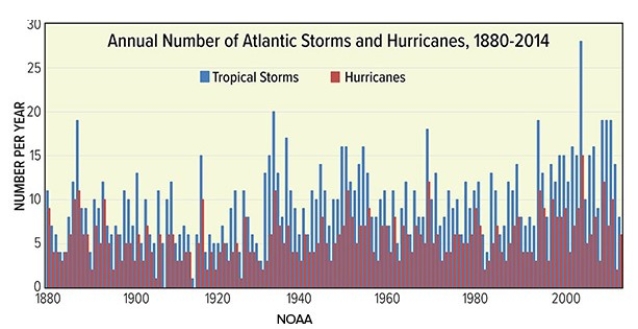
(Multiple Choice)
4.8/5 (36)
Which of the following best describes the location of B climates?
(Multiple Choice)
4.8/5 (35)
All of the following could be considered proxy data for measuring global warming except
(Multiple Choice)
4.9/5 (41)
Which climate designation would you assign to a location that is wet year-round,with a long hot summer and a short intermittent cold season?
(Multiple Choice)
4.9/5 (31)
What line or region best corresponds with the location of E climates?
(Multiple Choice)
4.8/5 (40)
Though Khartoum and Urumqi both have dry BW climates,temperatures are much more variable for Urumqi.Why? 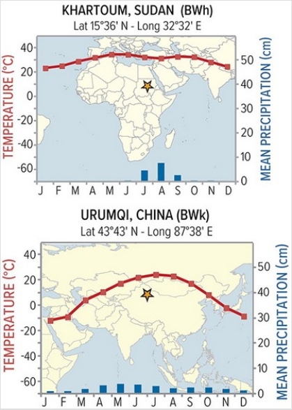
(Multiple Choice)
4.8/5 (32)
Thermometers directly measuring temperature data on a global scale show the most recent cooling period ended around 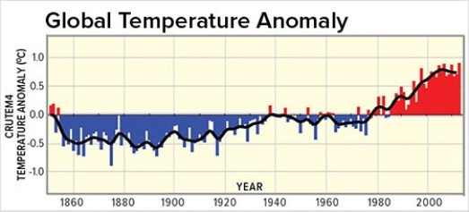
(Multiple Choice)
4.8/5 (43)
The accompanying graph shows the number of violent tornados in the last 60 years.Based on when most global warming has occurred,one would conclude 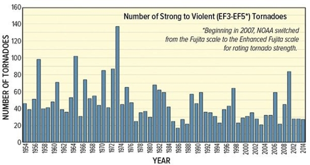
(Multiple Choice)
4.9/5 (39)
Using the Köppen classification system,a climate classified as a BW (Bw)would have
(Multiple Choice)
4.7/5 (35)
Which climate designation would you assign to a location that is wet in the winter but dry in the summer with a long hot summer and short intermittent cold season?
(Multiple Choice)
4.9/5 (38)
Filters
- Essay(0)
- Multiple Choice(0)
- Short Answer(0)
- True False(0)
- Matching(0)