Exam 12: Raster Data Analysis
We must manually convert all input rasters to the same cell size before using them in ArcGIS for a raster data operation.
False
Illustrate with a diagram a 3-by-3 neighborhood mean operation.
A 3-by-3 neighborhood mean operation involves taking the average of the pixel values within a 3x3 grid around each pixel in an image. This is commonly used in image processing to smooth out noise and reduce the impact of outliers.
To illustrate this operation with a diagram, we can represent a 3x3 grid around a central pixel as follows:
1 1 1
1 1 1
1 1 1
Each number in the grid represents a pixel value. To perform the neighborhood mean operation, we would calculate the average of all the pixel values in this 3x3 grid, including the central pixel. The result would then replace the value of the central pixel in the output image.
This process is repeated for every pixel in the image, resulting in a smoothed version of the original image. The neighborhood mean operation is a simple yet effective way to reduce noise and improve the overall quality of an image.
Which of the following can be used to extract data from an existing raster in ArcGIS?
E
How does a local operation differ from a neighborhood operation?
A zonal operation can be run with one input raster or two input rasters. How do these two types of zonal operations differ in terms of their applications?
You have downloaded from the Internet an elevation raster, which has values ranging from 94.7 to 2409.1 meters. But, for your project, you need a new integer raster with elevation values grouped into five classes: 1 (0-500), 2(500-1000), 3(1000-1500), 4(1500-2000), and 5(2000-2500). Describe how you can complete the task.
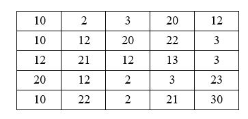
The following diagram shows a raster with its origin (0, 0) at the upper left corner. Suppose that the raster is used for a couple of 3-by-3 neighborhood operations. (1) What is the range statistic for (col. 3, row3)? (2) What is the majority statistic for (col. 3, row3)? (3) What is the variety statistic for (col. 3, row3)?
Suppose you are asked to produce a raster that shows the average precipitation in each major watershed in your state. Describe the procedure you will follow to complete the task.
Which of the following mathematical functions can be used for local operations?
An analysis mask limits analysis to cells that do not carry the cell value of 'no data.'
You have a slope raster and an aspect raster. The slope raster has 3 values: 1 for 0-20%, 2 for 20-40%, and 3 for >40%. The aspect raster has 5 values: 1 for flat area, 2 for north, 3 for east, 4 for south, and 5 for west. Describe the procedure you will follow to locate those areas with 20-40% slope and the south aspect.
A neighborhood operation on a raster requires the focus cell to move from one cell to another until all cells are visited.
Which local operation can assign a unique output value to each unique combination of cell values from multiple rasters?
The cell value of 'no data' is treated as zero in raster data operations.
A zonal operation on a single input raster produces measures of the zonal geometry.
Map algebra is limited to the use of a single layer as the input.
Explain how physical distance measures are calculated in a raster data operation.
Filters
- Essay(0)
- Multiple Choice(0)
- Short Answer(0)
- True False(0)
- Matching(0)