Exam 11: Vector Data Analysis
You are asked to prepare a preliminary map that shows land parcels in a county that meet the following two criteria: (1) within 300 meters of streams, and (2) located in a conservation priority area. You are given two digital maps for the study area: one showing streams and the other showing the priority areas. Describe the procedure that you will use to complete the task.
To prepare the preliminary map showing land parcels that meet the specified criteria, I will first overlay the two digital maps provided - one showing streams and the other showing conservation priority areas. This will allow me to identify the areas that meet both criteria.
Next, I will use a GIS software to perform a spatial analysis to identify land parcels that are within 300 meters of the streams and also located within the conservation priority areas. This will involve using spatial query tools to select and highlight the parcels that meet both criteria.
Once the parcels meeting both criteria are identified, I will create a new map layer that includes only these selected parcels. This will form the basis of the preliminary map showing the land parcels that meet the specified criteria.
Finally, I will add any necessary map elements such as a legend, scale bar, and title to the map to make it clear and informative. The resulting map will provide a visual representation of the land parcels that meet the specified criteria and can be used for further analysis and decision-making related to conservation and land use planning in the county.
You must use a polygon layer to define the area for clipping in a Clip operation.
True
What is the minimum mapping unit?
The minimum mapping unit (MMU) refers to the smallest size of a land area or feature that can be represented on a map at a given scale. It is essentially the smallest unit that can be reliably and consistently distinguished and mapped in the context of the data's resolution and the map's scale.
The MMU is determined by several factors, including the resolution of the data source (such as satellite imagery or aerial photography), the scale of the map, the precision of the mapping tools and techniques used, and the intended use of the map. For example, a map intended for detailed local planning might have a much smaller MMU than a map designed for regional overviews.
In the context of geographic information systems (GIS), the MMU is important because it influences the level of detail and accuracy of spatial data representations. A smaller MMU allows for finer detail and more precise mapping, but it also requires more data and can be more time-consuming and expensive to produce. Conversely, a larger MMU simplifies the data but may omit smaller features that could be important for certain analyses or decisions.
The concept of MMU is particularly relevant in land use and land cover mapping, where it helps to define the granularity of the categories that can be distinguished. For example, in a land cover map, the MMU will determine the smallest patch of forest or area of water that can be identified as such on the map.
In summary, the minimum mapping unit is a critical concept in cartography and GIS that defines the smallest feature that can be represented on a map, balancing the need for detail with practical considerations of data management and map usability.
Describe a scenario, in which Intersect is preferred over Union for an overlay operation.
You have downloaded a shapefile from a website that shows toxic waste sites in your state. Which operation will you use to get a map showing toxic waste sites within a 10-mile buffer zone map that you have made around your home?
Provide an application example in which a buffer zone is used as an exclusion zone.
Which overlay method combines the area extents from both input layers?
The following figure shows an overlay (Intersect) operation. "A" represents the input (polygon) layer with ID values from 1 to 4; "B" represents the intersect (polygon) layer with the ID values of 10 and 11; and "C" is a graphic representation of the overlay operation.
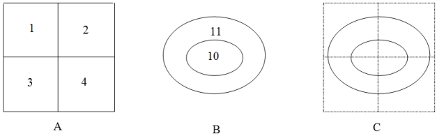 1) How many polygons will the output have?
2) How many records in the output will have the ID value of 3 from the input layer?
3) How many records in the output will have the ID value of 11 from the intersect layer?
1) How many polygons will the output have?
2) How many records in the output will have the ID value of 3 from the input layer?
3) How many records in the output will have the ID value of 11 from the intersect layer?
Which of the following analyses is also called multi-distance spatial clustering analysis?
Describe an example in which areal interpolation can be used as a problem-solving tool.
ArcGIS does not automatically update the area and perimeter values of an overlay output if shapefiles are used as the input layers.
Provide an application example in which a buffer zone is used as an inclusion zone.
Suppose an input layer shows a county and an overlay layer shows a national forest. Part of the county overlaps the national forest. We can express the output of an Intersect operation as [county] AND [national forest]. How can we express the outputs of a Union operation and an Identity operation (with the county as the input layer) using the Boolean Connector?
You have a land use map that shows land use classes of urban, agricultural, commercial, and so on. Which operation will you use to get a new map that only shows agricultural land use?
Which of the following statements is true about vector data analysis?
Intersect is an overlay method as well as a spatial join option. Will you get the same result from both operations?
Filters
- Essay(0)
- Multiple Choice(0)
- Short Answer(0)
- True False(0)
- Matching(0)